Tuesday, November 29, 2016
Alabama About to be Slammed
There are reports that there is potential for significant severe weather in Alabama. Rain and storms are happening currently, but into the night, there appears to be more potential danger. Tornadoes, hails, heavy rain, and strong winds are all possible to hit Alabama. Numerous severe storms are all possible throughout the state. Scattered severe storms, numerous severe storms, and isolated strong storms are all reported in numerous areas in Alabama. Supercell storms could form across western Mississippi and flow into Alabama. The warnings and watches have been reported to last until 6 a.m. on Wednesday.
Unfrozen Bridge Prevents Travelling
Dawson City thrives on the traveling of a frozen river. But this year, the river has frozen upstream. More than 100 people live off the gird and rely on the frozen river to travel. In the summer, ferries help with the traveling, but during the winter, they rely on the ice bridge. Since the river has frozen upstream, over 100 people are now stocking up and running low on storage. The weather has been relatively warmer so the freezing is not in sight. Some people are walking a few kilometres to travel across the frozen sections. It has added more than two hours to traveling on a toboggan. Some people have considered moving due to the inconvenience.
Why Do So Many Big Earthquakes Strike Japan?

A magnitude-6.9 earthquake struck yesterday off the coast of Fukushima, Japan, likely along the same fault that ruptured in 2011, unleashing a massive 9.0-magnitude temblor that triggered deadly tsunamis and caused widespread destruction. Over the course of its history, Japan has seen its share of shaking, but what makes this part of the world so susceptible to big earthquakes?
The answer has to do with Japan's location. The island nation lies along the so-called Pacific Ring of Fire, an imaginary horseshoe-shaped zone that follows the rim of the Pacific Ocean, where many of the world's earthquakes and volcanic eruptions occur. In fact, 81 percent of the world's largest earthquakes happen in this active belt, according to the U.S. Geological Survey (USGS). [Image Gallery: This Millennium's Destructive Earthquakes]
"The Earth's surface is broken up into about a dozen or so major chunks that are all moving around. Where they all interact at their edges, interesting things happen," Douglas Given, a geophysicist with the USGS in Pasadena, California, previously told Live Science.
Within the Pacific Ring of Fire, several tectonic plates mash and collide. In what are known as subduction zones, one plate bends and slides underneath the other, causing the oceanic crust to sink into the Earth's mantle.
"From Alaska down to Japan and the Philippines, all the way down around the western Pacific — and then the boundary of the west coast of South America and central America — are all big subduction zones," said Robert Smith, an emeritus professor of geophysics at the University of Utah.
Japan itself sits atop a complex mosaic of tectonic plates that grind together and trigger deadly earthquakes and volcanic eruptions, Smith told Live Science.
Yesterday's earthquake off the coast of Fukushima was centered about 80 miles (130 kilometers) southwest of the epicenter of the 9.0-magnitude Tohoku quake that struck in March 2011. This means the magnitude-6.9 temblor could be an aftershock of the more-powerful 2011 quake, according to seismologists.
"There's been a whole sequence [of aftershocks] since the 2011 earthquake," Smith said. "These enormously big earthquakes have aftershocks that can continue for tens to hundreds of years. It's very common."
The 2011 earthquake released hundreds of years of pent-up stress within the subduction zone and triggered an enormous tsunami that inundated the coastal Fukushima Daiichi Nuclear Power Plant, eventually causing a level 7 nuclear meltdown. While yesterday's quake was not as powerfulas the Tohoku temblor, the entire region is still at risk of big earthquakes.
The Tohoku quake "was one of the biggest earthquakes we've recorded historically, but the fact is, the seismic hazard of the whole subduction zone is extremely high, so large earthquakes are more common there than other places," Smith said.
Earlier this year, in April, a magnitude-7.0 earthquake struck the Kumamoto region in southern Japan, two days after a 6.2-magnitude temblor shook the same area.
http://www.livescience.com/56973-why-so-many-big-earthquakes-strike-japan.html
India's Himalayas are on fire due to high temperatures and low rains

Deadly forest fires across India’s Himalayan state of Uttarakhand have burned more than 2,300 hectares of forests and killed six people. The fires started three months ago, but had increased in intensity in the last few days.
While forest fires are an annual summer occurrence in the region, officials say that the increased intensity this year is because of the forests being drier due to unexpectedly high temperatures and low rainfall in the last two years. Others have argued that the fires were started illegally by timber traders.

According to India’s environment minister Prakash Javadekar, 70% of the blazes had been doused by May 2 and their numbers reduced from 1,200 to 60. The National Disaster Relief Force (NDRF), the Indian army, air force and 6,000 fire-fighters are involved in the efforts to save the forests.
http://mashable.com/2016/05/02/india-uttarakhand-forest-fire/#IkLONfQ6skqP
Severe monsoon rains cause floods and landslides across India

Severe monsoon rainstorms wreaked havoc across several Indian states causing floods and landslides on July 17 and 18, 2016. 35 people died in Madhya Pradesh alone while several others went missing. Water, power supplies, and traffic were disrupted across the affected areas.
Heavy rains triggered landslides in the mountainous regions of Uttarakhand and blocked the road connecting Haridwar and Delhi. 12 people were reported dead across the state, four of which were buried by a landslide near Narendra Nagar. Severe infrastructural damage was reported, including damaged bridges, while 440 roads were blocked for traffic.
More than 300 villages and 100 000 people are affected by severe weather conditions in Assam, the districts of Lakhimpur, Golaghat, and Morigaon being among the worst hit. According to the Assam State Disaster Management Authority (ASDMA), the Brahmaputra river was flowing above the danger level.
https://watchers.news/2016/07/18/severe-monsoon-rains-cause-floods-and-landslides-across-india/
Louisiana flood: Worst US disaster since Hurricane Sandy, Red Cross says
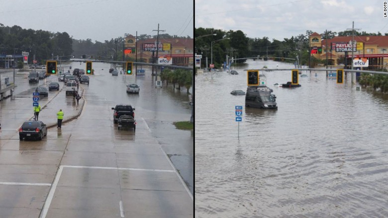
Livingston Parish, Louisiana (CNN)The catastrophic flood devastating Louisiana is now the worst natural disaster to strike the United States since Hurricane Sandy four years ago, the Red Cross said.
"Thousands of people in Louisiana have lost everything they own and need our help now," said Brad Kieserman, the Red Cross' vice president of disaster services operations and logistics.
"This disaster is the worst to hit the United States since Superstorm Sandy, and we anticipate it will cost at least $30 million -- a number which may grow as we learn more about the scope and magnitude of the devastation."
The calamity struck quickly and ferociously. In one part of Livingston Parish, more than 31 inches of rain fell in 15 hours.

Louisiana: One family, 13 homes destroyed 01:45
"I bought enough food to last for a week in case we were flooded in, but I wasn't prepared for this much devastation," said Jo Lee Misner, who lives in the Livingston Parish community of Colyell. "Local stores are running low on everything from food to fuel."
At least 36 of her relatives have lost their homes -- all 13 of them.
"It's unbelievable what we've been through," she said. "We never imaged this would happen."
And it's not over. At least 13 people have died across five parishes. And with more rain forecast, the destruction could mount.
http://www.cnn.com/2016/08/18/us/louisiana-flooding/
Matthew one of the most powerful Atlantic hurricanes in recent history
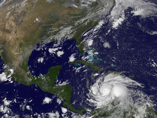
Hurricane Matthew smashed its way through the Caribbean and roared toward Haiti , Jamaica and Cuba on Sunday, a Category 4 storm powered by 145-mph winds that could pose a threat to the United States by week's end.
Matthew briefly reached maximum Category 5 status Friday, making it the strongest Atlantic hurricane in almost a decade. Late Sunday, the storm was located about 265 miles south-southeast of Kingston, Jamaica , and was crawling west at 3 mph.
The latest National Hurricane Center projection had Matthew reaching the southwestern tip of Haiti late Monday, but tropical storm conditions could reach Jamaica and Haiti as soon as late Sunday and eastern Cuba early Monday. The storm was expected to remain a powerful and dangerous hurricane into Tuesday, forecasters said.
"Preparations to protect life and property should be rushed to completion," the hurricane center warned on its Facebook page.
Matthew could dump up to 25 inches of rain over much of southern Haiti, with "isolated maximum amounts of 40 inches," the hurricane center warned. Eastern Jamaica, the Dominican Republic and eastern Cuba could see 10 to 20 inches of rain with 25 inches in isolated areas. In addition, storm surges in the region could cause catastrophic flooding.
Although the official forecast on Sunday showed a track east of Florida, the hurricane center said it was still too soon to rule out possible possible hurricane impacts there — or how Matthew might affect the remainder of the U.S. east coast.
In Haiti, families were being urged to stock up on food and water, and evacuations were underway in high-risk areas. The Haitian Civil Protection Agency said it had 576 temporary shelters available that can accommodate up to 88,252 people for at least 3 days.
"This could be catastrophic for some places, particularly Haiti," National Hurricane Center meteorologist Dennis Feltgen told USA TODAY. "This is an area where trees just don't exist (due to deforestation). The terrain is stripped, and the threat of major flash floods and mudslides is very real."
http://www.usatoday.com/story/weather/2016/10/02/matthewcategory-4-hurricane/91431066/
Study sees climate change in action in the air, watching carbon dioxide trap heat

By SETH BORENSTEIN, AP Science Writer
WASHINGTON (AP) — Scientists have witnessed carbon dioxide trapping heat in the atmosphere above the United States, chronicling human-made climate change in action, live in the wild.
A new study in the journal Nature demonstrates in real-time field measurements what scientists already knew from basic physics, lab tests, numerous simulations, temperature records and dozens of other climatic indicators. They say it confirms the science of climate change and the amount of heat-trapping previously blamed on carbon dioxide.
Researchers saw "the fingerprint of carbon dioxide" trapping heat, said study author Daniel Feldman of the Lawrence Berkeley National Laboratory in California. He said no one before had quite looked in the atmosphere for this type of specific proof of climate change.
Feldman and colleagues used a decade of measurements from instruments in Alaska and Oklahoma that looked straight up into the sky and matched what they saw with the precise chemical composition and heat fingerprints of carbon dioxide trapping heat. Scientists say carbon dioxide from the burning of coal, oil and gas is the chief cause of global warming.
http://stem-works.com/external/article/1187
From Space, Typhoon Maysak's Eye Looks Like a Black Hole

The astronauts living and working on the International Space Station are eye to eye with a deadly super typhoon as it heads toward the Philippines.
And from more than 200 miles (320 kilometers) above Earth, the mass of clouds swirling around the dark eye of the monster storm Maysak almost resembles the disk of glowing matter being pulled into a black hole.
"Looking down into the eye - by far the widest one I've seen. It seemed like a black hole from a Sci-Fi movie," NASA astronaut Terry Virts wrote on Twitter. The eye of the storm stretches 17 miles (27 km) across, according to NASA.
Virts and his fellow astronauts have been posting pictures of the typhoon, which is expected to hit the Philippines this weekend if it doesn't change course.
"Commands respect even from space," wrote Samantha Cristoforetti, an Italian astronaut with the European Space Agency who launched into space with Virts in November. (The shot of Maysak that Cristoforetti posted on Twitter might look like it's upside down, but astronauts often feel like they're looking up at Earth from inside the Cupola, a seven-windowed room aboard the space station with the best views.)
http://stem-works.com/external/article/1242
How High Will the Seas Rise, Really?

This article was originally published at The Conversation. The publication contributed the article to Live Science's Expert Voices: Op-Ed & Insights.
A recent high-profile study led by US climatologist James Hansen has warned that sea levels could rise by several meters by the end of this century. How realistic is this scenario?
We can certainly say that sea levels are rising at an accelerating rate, after several millennia of relative stability. The question is how far and how fast they will go, compared with Earth's previous history of major sea-level changes.
Seas have already risen by more than 20 cm since 1880, affecting coastal environments around the world. Since 1993, sea level has been rising faster still (see chapter 3 here), at about 3 mm per year (30 cm per century).
One key to understanding future sea levels is to look to the past. The prehistoric record clearly shows that sea level was higher in past warmer climates. The best evidence comes from the most recent interglacial period (129,000 to 116,000 years ago), when sea level was 5-10 m higher than today, and high-latitude temperatures were at least 2℃ warmer than at present.
The two largest contributions to the observed rise since 1900 are thermal expansion of the oceans, and the loss of ice from glaciers. Water stored on land (in lakes, reservoirs and aquifers) has also made a small contribution. Satellite observations and models suggest that the amount of sea-level rise due to the Greenland and Antarctic ice sheets has increased since the early 1990s.
Before then, their contributions are not well known but they are unlikely to have contributed more than 20 percent of the observed rise.
Together, these contributions provide a reasonable explanation of the observed 20th-century sea-level rise.
Future rise
The Intergovernmental Panel on Climate Change (IPCC) projections (see chapter 13 here) forecast a sea-level rise of 52-98 cm by 2100 if greenhouse emissions continue to grow, or of 28-61 cm if emissions are strongly curbed.
The majority of this rise is likely to come from three sources: increased ocean expansion; glacier melt; and surface melting from the Greenland ice sheet. These factors will probably be offset to an extent by a small increase in snowfall over Antarctica.
With continued emissions growth, it is entirely possible that the overall rate of sea-level rise could reach 1 m per century by 2100 — a rate not seen since the last global ice-sheet melting event, roughly 10,000 years ago.
Beyond 2100, seas will continue to rise for many centuries, perhaps even millennia. With continued growth in emissions, the IPCC has projected a rise of as much as 7 m by 2500, but also warned that the available ice-sheet models may underestimate Antarctica's future contribution.
The joker in the pack is what could happen to the flow of ice from the Antarctic ice sheet directly into the ocean. The IPCC estimated that this could contribute about 20 cm of sea-level rise this century. But it also recognised the possibility of an additional rise of several tens of centimeters this century if the ice sheet became rapidly destabilised.
What Causes Eerie Volcanic Lightning?


Volcanic eruptions, like this one at Sakurajima volcano in Japan, generate amazing displays of lightning.
Credit: Corrado Cimarelli.
At nighttime, ominous lightning flashes above erupting volcanoes light up the sky like a living nightmare. Now, scientists are closer to understanding volcanic lightning, which stems from both ash and ice, two new studies reveal.
Unraveling the origin of volcanic lightning has been difficult. In thunderstorms, the culprits are colliding ice crystals, which generate enough of an electric charge to trigger lightning. But ash clouds are less predictable and harder to study than supercells (thunderstorms), so scientists are still trying to figure out what sets off volcanic lightning. For instance, it seems absurd to blame ice for lightning in a volcanic inferno.
Two new studies reveal different reasons for lightning above erupting volcanoes. One cause is static electricity, from particles rubbing together in dense ash clouds near the ground. The other source of lightning happens near the stratosphere, high above the Earth's surface, where jockeying ice crystals unleash powerful jolts. [Images: Grimsvotn Volcano Puts on Lightning Show]
At Sakurajima volcano in Japan, ash particles are responsible for lightning that strikes near the ground, researchers led by Corrado Cimarelli, a volcanologist at Ludwig Maximilian University in Munich, Germany, reported Feb. 23 in the journal Geophysical Research Letters. For that study, the scientists recorded video of volcanic lightning at Sakurajima, one of the world's most active volcanoes. By comparing the video to infrasound and electromagnetic data, the researchers discovered thick clouds of ash give rise to static electricity. The particles rub together and the resulting charge buildup generates lightning strikes. (This is called triboelectricity.)
Ice also plays a role in volcanic lightning, a separate study found. Researchers tracked the location of lightning strikes during an April 2015 eruption of Calbuco volcano in Chile. In this case, the bolts were breaking some 60 miles (about 100 kilometers) from the eruption, and at near-stratospheric heights of about 12 miles (20 km) above Earth's surface. The scientists think ice formed in the top of the thinning ash cloud — which was also carrying water vapor — producing lightning like a thundercloud does. The study was published April 12 in Geophysical Research Letters.


A look at the April 2015 eruption of Calbuco volcano in Chile, which produced volcanic lightning.
Credit: Carolina Barría Kemp -- https://www.flickr. com/photos/25890105@N02/17250346125/
These discoveries could have important implications for volcano monitoring. Because larger eruptions trigger more lightning, "simply seeing that lightning is associated with an eruption tells you that there are potential aviation issues," said Alexa Van Eaton, lead author of the Calbuco study and a volcanologist at the U.S. Geological Survey Cascades Volcano Observatory in Vancouver, Washington.
During the March eruption of Alaska's Pavlof volcano, Van Eaton and her colleagues used the World Wide Lightning Location network to monitor the volcano's ash cloud, she said. The ash from Pavlof and other southwest Alaska volcanoes can drift into international and local flight paths.
Van Eaton ultimately hopes to use lightning flashes to gauge the power of volcanic eruptions remotely. "Lightning is telling us things that other geophysical monitoring techniques can't see," van Eaton told Live Science. Bigger eruptions trigger more lightning, van Eaton said. "Simply seeing that lightning is associated with an eruption tells you that there are potential aviation issues, and it informs the way you respond to a volcano," she said.
Both studies also bring scientists closer solving the mystery of volcanic lighting. "It's surprising that there are really different processes inside a volcanic eruption plume system that generate electrification," van Eaton said. "It opens a world of questions that we didn't even know existed."
http://stem-works.com/external/article/1528
Japanese Volcano Sakurajima Due for Major Eruption

Sakurajima is one of the most active volcanoes in Japan, with eruptions occurring daily. New research suggests the volcano is due for a major eruption in the next 25 years.
Credit: Sakurajima Volcano Research Centre
A Japanese volcano that last erupted in 1914 could be set to blow in the next few decades, new research suggests.
The pool of liquid magma swelling beneath Sakurajima volcano is growing every year — a sign of a growing threat.
"This big reservoir is growing, and it's growing at quite a fast rate," said study co-author James Hickey, a geophysical volcanologist at the University of Exeter's Camborne School of Mines in England.
At the current rate, Sakurajima could erupt catastrophically in about 25 years, according to the study.
The new analysis could also help scientists better forecast when other big volcanoes could erupt, the researchers said. [Raw Video: Volcano in Southern Japan Erupts]
Major eruptions
Sakurajima volcano, located on the southwestern edge of Japan's Kyushu island, last erupted in 1914, killing 58 people and causing a massive flood in the nearby seaside city of Kagoshima. Sakurajima is fed by a pool of magma lying beneath the subterranean Aira caldera, and the filling of this magma reservoir causes the volcano to have minor eruptions roughly every day.
In the 1950s, scientists tried to quantify the risk of future eruptions at Sakurajima by using a simple model, assuming the Earth's surface above the volcano was flat and that the pool of magma was spherical. The model had a big advantage: "You can basically solve it with pen and paper," Hickey told Live Science.
However, over the years, scientists realized that this ultrasimplified model did not match volcanic activity at Sakurajima.
http://www.livescience.com/56067-scientists-forecast-sakurajima-major-eruption.html
Subscribe to:
Posts (Atom)