Thursday, October 31, 2019

East Africa Reels From Deadly Floods

https://phys.org/news/2019-10-east-africa-reels-deadly-extreme.html


Some parts of northern Kenya received a year's worth of rain in a matter of weeks. A Turkana woman is shown here outside her hom

A powerful climate phenomenon in the Indian Ocean stronger than any seen in years is unleashing destructive rains and flooding 
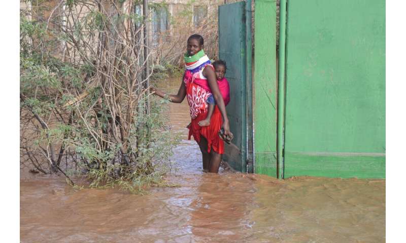
across East Africa—and scientists say worse could be coming. Violent downpours in October have displaced tens of thousands in Somalia, submerged whole towns in South Sudan and killed dozens in flash floods and landslides in Kenya, Ethiopia and Tanzania. Rising waters have wiped out livestock and destroyed harvests in swathes of the region still reeling from severe drought. Close to a million people in South Sudan alone are affected, with growing fears of disease outbreaks and starvation. The extreme weather is blamed on the Indian Ocean Dipole—a climate system defined by the difference in sea surface temperature between western and eastern areas of the ocean. At the moment, the ocean around East Africa is far warmer than usual, resulting in higher evaporation and moist air flowing inwards over the continent as rain: the hallmarks of a "positive" dipole. But scientists say the strength of this dipole is of a magnitude not seen in years, perhaps even decades. These waters around East Africa are about two degrees warmer than those of the eastern Indian Ocean near Australia—an imbalance well beyond the norm.

Rare Hurricane-like Storm in Mediterranean Threatens Egypt, Israel


Rare hurricane-like storm in Mediterranean threatens Egypt, Israel


Egypt and Israel are preparing for the onset of heavy rains and strong winds as a rare "medicane" barrels toward them. Medicanes are named for a combination of "Mediterranean" and "hurricane" due to their blend of tropical and extratropical cyclone characteristics. Up to 200 mm (nearly 8 inches) of rain is possible locally from Friday to late Saturday as the storm moves through the region, raising concerns for flash flooding. Northeastern Egypt, southern Israel, the Palestinian territories and the Sinai Peninsula are arid regions that receive an average of 10-20 mm (nearly half an inch to almost an inch) of rain in October. This storm may bring 10 times as much rain as normally falls in the entire month of October and it could fall in only a few hours. Egypt's capital, Cairo, has experienced severe flooding from heavy rains already this past week from an unrelated storm system, killing at least 11 people. Cairo may fortunately miss the worst of the rainfall as the system moves past the city to the east. Satellite imagery suggests current wind speeds upward of 20 mph at sea, and some models suggest that sustained wind speeds of 40 mph may be felt on shore early Saturday morning.

Hurricane Center Watching New Tropical System With Chances of Development


A tropical disturbance was detected Thursday morning. The system has a 10 percent chance of developing into a tropical depression over the next two to five days, according to the National Hurricane Center's 8 a.m. Thursday update.

As Subtropical Storm Rebekah moves east toward Europe, a new system with chances of tropical development appeared Thursday morning and is moving west, the National Hurricane Center said in its 8 a.m. update. The broad area of disturbed weather appeared Thursday morning about 1,000 miles south-southwest of the Cabo Verde Islands, the NHC said. It has a 10 percent chance of tropical development in the next two to five days, although it is expected to encounter unfavorable conditions this weekend with the presence of upper-level winds. If the system can find circular wind motion, it will become Tropical Depression 19. If it is able to organize and sustain maximum winds of 39 mph or higher, it will become Tropical Storm Sebastien.