Tuesday, October 30, 2018

Strong Indian monsoons steer Atlantic hurricanes towards land, study finds


Strong monsoons in the Indian Ocean can induce easterly winds that push Atlantic Ocean hurricanes westward, increasing the likelihood they'll make landfall in the Americas, according to new research.
A new study finds that in years where summer rainstorms in India are stronger, Atlantic hurricanes move further westward towards land. In years where the rains aren't as strong, hurricanes tend to curve northward earlier and fizzle out in the north Atlantic Ocean.
This newly-discovered relationship could help scientists better predict the path of oncoming hurricanes, especially in late summer months like September, when Atlantic hurricane activity peaks, according to the study's authors.
"What amazes me is how rainfall near India can drive important changes to Atlantic hurricanes half a world away," said Patrick Kelly, an atmospheric researcher at the Department of Energy's Pacific Northwest National Laboratory in Richland, Washington and lead author of the new study in Geophysical Research Letters, a journal of the American Geophysical Union. "This research is the first to draw the connection between Atlantic hurricanes and the Indian monsoon."

https://www.sciencedaily.com/releases/2018/10/181023150032.htm

Meteorologist expects severe drought and heavy rain events to worsen globally


https://www.sciencedaily.com/releases/2018/10/181025141009.htm
A University of Oklahoma meteorologist, Elinor R. Martin, expects severe drought and long-lasting rainfall events to worsen in the future. In Martin's new study just published, she determines how frequent, intense and long lasting these types of events will be in the future. Martin looks at both severe drought and rain events, but it is the first time extended heavy rain events have been studied.
"In some places, there will be more frequent droughts, and other places can expect more frequent rainfall," said Martin, professor in the School of Meteorology, OU College of Atmospheric and Geographic Sciences. "The Caribbean and Central America will have more extreme droughts and the north and northeast of North America can expect more extreme heavy rain events. Around the world, some places will see droughts and heavy rain events become more intense, longer lasting and more frequent. For the agriculture and related industries, this is particularly important."
Globally, there are areas that will overall become wetter and areas that will become drier. When it gets warmer, the water builds up and it rains for long periods, but there will be longer periods between rain events and in places, it will become drier. Even regions that are projected to become drier overall, like the Southwest and South Central United States, are expected to see more severe, longer and frequent periods of heavy rain. Martin refers to the May 2015 rain event in Oklahoma and Texas as one example of what could be expected in the future.
"When it gets warmer, water vapor can build up in the atmosphere, so when it does rain it rains a lot and for long periods, but there will be longer periods between rain events so droughts will become worse." said Martin. She points to a changing climate as the reason these events will worsen, and defines droughts and rain events by using a standardized rainfall index to compare events between regions and seasons. For this study, Martin used the same climate models as the Intergovernmental Panel on Climate Change.

Ashley amezcua


                  Volcanos Near Vancouver are very High 
a close up of a tree: Mount St. Helens eruption in 1980.
On May 18, 1980, Mount St. Helens blew its top, killing 57 people.
maybe a repeat will happen in these volcanos
It's an event many people in B.C. remember: ash easily made its way to Metro Vancouver, and some of it even travelled as far as Edmonton.
According to the United States Geological Survey (USGS), the threat of a repeat remains very real.
https://www.msn.com/en-ca/weather/topstories/4-volcanoes-near-vancouver-‘very-high-threat’-but-experts-say-no-need-to-duck-and-cover/ar-BBOUACN

Are Extreme Weather Events Linked to Climate Change?

It seems the news has no shortage of extreme weather events: wildfires raged across Greece and the northwestern United States, flooding washed out the northeastern US, and intense heatwaves blanketed Japan and the United Kingdom. The island of Puerto Rico is facing down another hurricane season while many areas only recently regained power after Hurricane Maria devastated the island in 2017.
If it feels like we are hearing about extreme weather events more and more frequently now, it’s because we are. Large fires are now five times more common and fire season lasts three months longer than 40 years ago. The most intense rainstorms have increased by as much as 70% in the last 50 years and the city of Houston, Texas has seen three five-hundred-year floods—that is, floods so intense they are only expected to happen once every 500 years—in the last 3 years.
What does science say about the link between climate change and this increase in extreme weather? Can we attribute a single event, like a particular heat wave or wildfire or flood, to climate change?

Severe Weather, High Wind Gusts Leave Thousands in Dark in N. Michigan

Thousands across Northern Michigan are left in the dark early Thursday morning.
There have already been reports of trees down in Emmet County.
A viewer in Sault Ste. Marie sent us a video of sparking wires down in trees.
Consumers Energy warns not to approach these wires if they are down in the road.
 
The severe weather will continue to leave a strong impact on much of Northern Michigan so preparation is important.
Among the counties most affected are:
Grand Traverse, Benzie, Manistee, Emmet, Leelanau and Cheboygan.
Power crews are out working to restore the power.
Be sure to stay with Northern Michigan’s News Leader as we work to bring you the latest details on when the power will be back on.

Tricky weather could ruin Halloween treats in Houston

https://www.click2houston.com/weather/tricky-weather-could-ruin-halloween-treats-in-houston

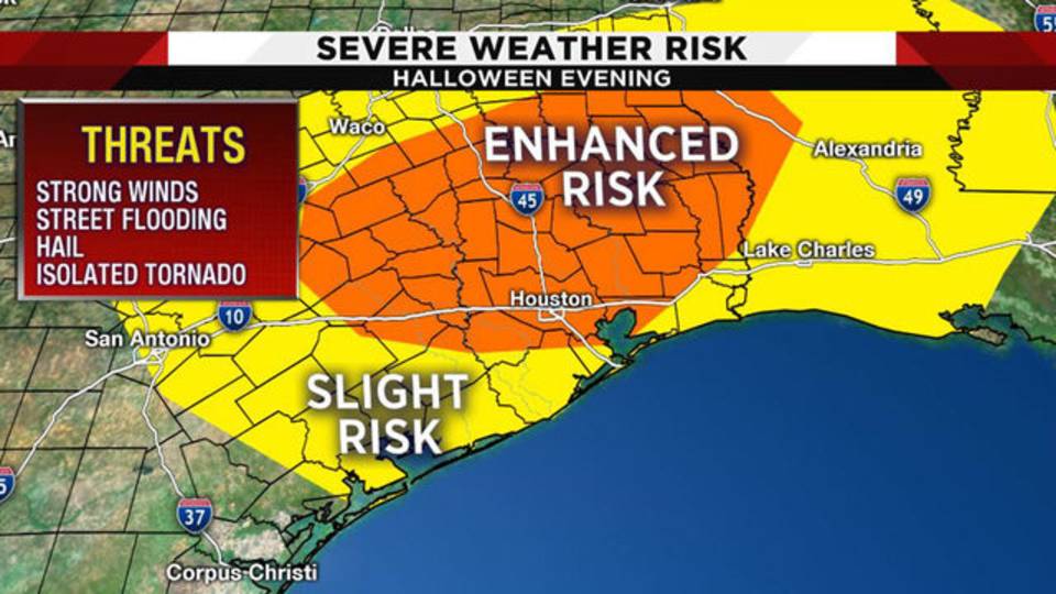
HOUSTON - Trick-or-treaters might have to contend with stormy weather on Halloween as a cold front moves through the Houston area.

Storm risk for Halloween 10-30-18Tuesday will feature sunny skies, warm temperatures and humid conditions ahead of a strong front that will usher much colder weather into Southeast Texas.

Meteorologist Britta Merwin said that while a few storms are possible ahead of the front, the bulk of the rain will arrive with the passage of the system. The front begins arriving in the northern counties about 10 p.m. with the metro area seeing storms about midnight. Coastal counties will see storms starting about 2 a.m. Thursday.
Merwin said that some storms are possible when most people go trick-or-treating, but it is almost impossible to pinpoint where storms will pop up ahead of the cold front.
Some storms will likely be severe. The Houston area is under an enhanced risk of severe weather, which means high winds, hail and isolated tornadoes are possible.

WEATHER-TRAFFIC UPDATE: Sunshine to warm Atlanta to the low 70s

https://www.ajc.com/weather/tuesday-weather-traffic-sunshine-warm-atlanta-the-low-70s/Z7uR3tzsJNf7bwgTBrxcpN/

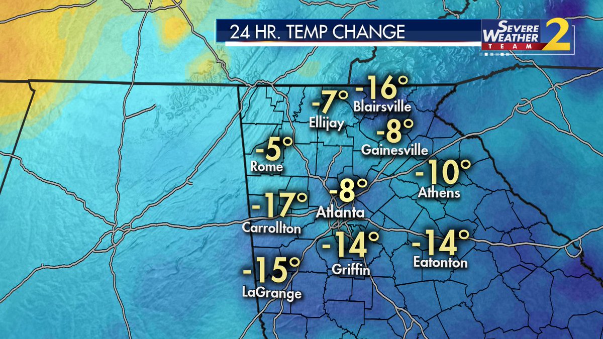
North Georgia woke up to cooler temperatures Tuesday than the day before, but the region should warm up considerably now that the sun is up, according to Channel 2 Action News.

Some spots in the mountains started in the 30s, while Atlanta started in the 40s and is warming into the 50s, the news station reported. Temperatures across North Georgia were 5 to 16 degrees cooler than Monday morning, Channel 2 meteorologist Karen Minton said.

“We're starting out a little chilly,” she said. “ ... Pull on that jacket before you head on out.”

With plenty of sunshine on tap for Tuesday, Minton said metro Atlanta can expect a nice increase in temperatures.

“High pressure is in place,” she said.  “It is going to keep us dry for today, and warm, too, with many areas rising into the lower 70s this afternoon.”

More dry, warm weather is expected Wednesday for Halloween with a high of 76 degrees. When most trick-or-treaters begin their candy grab about 7 p.m., Minton expects temperatures to be in the lower 70s. By 9 p.m., temperatures should still be in the upper 60s.

“It’s going to be nice for us during the day tomorrow for Halloween, although clouds will begin to increase as we go through Wednesday,” she said.

Minton said a “weather-maker” cold front is on its way to the state and is expected to bring showers and some storms Thursday. The models are still changing, she said, so the timing of the rain is still uncertain.