Showing posts with label Camarin Cruz. Show all posts

Monday, November 11, 2013

Cosmic Rays, Solar Activity Don't Cause Climate Change

By Laura Dattaro Published: Nov 11, 2013, 11:43 AM EST weather.com

Changes in solar activity contribute little to the increasing global temperatures observed in the 20th century, authors of a new study say.
In public discourse about climate change, some have proposed that natural fluctuations in the sun’s activity can account for the observed global warming, in opposition to increasing scientific evidence that carbon dioxide emissions and other human activities drive the changing climate. But new research by physicists Terry Sloan of the University of Lancaster and Arnold Wolfendale at the University of Durham refute this claim, demonstrating that solar activity contributed minimally to Earth’s changingtemperatures
The sun passes through regular 11-year activity cycles, which affect the rates at which streams of charged particles called cosmic rays hit the Earth. Past theories have proposed that cosmic rays hitting particles in the atmosphere can encourage cloud formation, helping the Earth to cool. In times of increased solar activity, then, fewer clouds would form as fewer cosmic rays made their ways to Earth.
But the new study finds little correlation between sun activity and an increasingly warmer planet. Using two data sets going back to 1955, the study’s authors found that a small correlation between cosmic rays and global temperatures occurred every 22 years, but the rate of change did not line up directly with change in temperature. They concluded that changes to cosmic rays could have contributed about 14 percent of measured changes in temperature since 1960.
“We cannot explain [the correlation] and it might be a lucky coincidence,” Sloan told Weather.com.
The research also reviewed previous studies, including the authors’ own work, and concluded that changing solar activity, either directly or through cosmic ray deflection, contributed 10 percent or less to the total increase in global temperature in the 20th century.
So how did the theory form that cosmic rays and cloud formation caused climate change? Sloan points to an early study that found a decrease in cloud cover at a time of maximum cosmic rays. “They did a back-of-the-envelope calculation to show that all global warming was due to changes in cloud cover,” Sloan said. “Other people as well as us have looked at this hypothesis and found that it does not fit lots of other data. Hence the correlation they saw must have been a coincidence.”
The study was published in the journal Environmental Research Letters.
Play Video
Overlay

Hubble Space Telescope Spots Strange Asteroid with 6 Tails of Dust

Marcia Dunn Published: Nov 8, 2013, 8:08 AM EST Associated Press

CAPE CANAVERAL, Fla. -- This is one strange asteroid.
The Hubble Space Telescope has discovered a six-tailed asteroid in the asteroid belt between the orbits of Mars and Jupiter. Scientists say they've never seen anything like it. Incredibly, the comet-like tails change shape as the asteroid sheds dust. The streams have occurred over several months.
Play Video
Overlay

MUCH Greater Asteroid Threat

Autoplay
ON
OFF
A research team led by the University of California,Los Angeles, believes the asteroid, designated P/2013 P5, is rotating so much that its surface is flying apart. It's believed to be a fragment of a larger asteroid damaged in a collision 200 million years ago.
Scientists using the Pan-STARRS telescope in Hawaii spotted the asteroid in August. Hubble picked out all the tails in September.
The discovery is described in this week's issue of Astrophysical Journal Letters.

MORE ON WEATHER.COM: Seeing Snow From Space

February 19, 2007

February 19, 2007
NASA

Typhoon Haiyan Update: Aid Trickles Into the Philippines as Massive Cleanup Effort Begins

weather.com and Associated Press Published: Nov 11, 2013, 11:03 AM EST

Haiyan is no longer a typhoon, but the destruction it left in the Philippines will take months or even years to overcome.
The typhoon-ravaged Philippine islands faced an unimaginably huge recovery effort that had barely begun Monday. As the official death toll rises to 942, many more bodies lay uncollected and uncounted in the streets and survivors pleaded for food, water and medicine.
Military spokesman Lt. Jim Alagao said 275 others were confirmed missing from the storm. The death toll is expected to rise considerably. Two provincial officials predicted Sunday that it could reach 10,000 or more.
Police guarded stores to prevent people from hauling off food, water and such non-essentials as TVs and treadmills, but there was often no one to carry away the dead - not even those seen along the main road from the airport to Tacloban, the worst-hit city along the country's remote eastern seaboard.
At a small naval base, eight bloated corpses - including that of a baby - were submerged in sea water brought in by the storm. Officers there had yet to move them, saying they had no body bags or electricity to preserve them.
Play Video
Overlay

Typhoon Haiyan: How You Can Help

Autoplay
ON
OFF
Two officials said Sunday that Friday's typhoon may have killed 10,000 or more people, but with the slow pace of recovery, the official death toll remained well below that. The Philippine military confirmed 942 dead, but shattered communications, transportation links and local governments indicate that the final toll will take days to be known. Presidential spokesman Edwin Lacierda said "we pray" that the death toll is less than 10,000.
"Haiyan is now just a remnant low over southern China, after coming ashore south of Hanoi, Vietnam Sunday afternoon (U.S. time)," said weather.com Senior Meteorologist Jon Erdman. "This ended an over one-week journey, from Micronesia to Palau to the Philippines and finally to northern Vietnam and China."
Tacloban resembled a garbage dump from the air, punctuated only by a few concrete buildings that remained standing.
"I don't believe there is a single structure that is not destroyed or severely damaged in some way - every single building, every single house," U.S. Marine Brig. Gen. Paul Kennedy said after taking a helicopter flight over the city. He spoke on the tarmac at the airport, where two Marine C-130 cargo planes were parked, engines running, unloading supplies.
Authorities said at least 2 million people in 41 provinces were affected by Haiyan, one of the most powerful recorded typhoons to ever hit land and likely the deadliest natural disaster to beset this poor Southeast Asian nation.
Philippine soldiers were distributing food and water in Tacloban, and assessment teams from the United Nations and other international agencies were seen for the first time. The U.S. military dispatched food, water, generators and a contingent of Marines to the city, the first outside help in what will swell into a major international relief mission.
Play Video
Overlay

Entire Towns Destroyed by Typhoon

Autoplay
ON
OFF
"Please tell my family I'm alive," said Erika Mae Karakot, a survivor on Tacloban's Leyte island, as she lined up for aid. "We need water and medicine because a lot of the people we are with are wounded. Some are suffering from diarrhea and dehydration due to shortage of food and water."
Authorities had evacuated some 800,000 people ahead of the typhoon, but many evacuation centers - brick-and-mortar schools, churches and government buildings - could not withstand the winds and water surges. Officials said people who had huddled in these buildings drowned or were swept away.
Emily Ortega, 21 and about to give birth, was among those who had thought she was safe. But the evacuation center she had fled to was devastated by the 6-meter (20-foot) storm surge, and she had to swim and cling to a post to survive. She reached safety at the airport, where she gave birth to a baby girl. Bea Joy Sagales appeared in good health, and her arrival drew applause from others in the airport and military medics who assisted in the delivery.
The winds, rains and coastal storm surges transformed neighborhoods into twisted piles of debris, blocking roads and trapping decomposing bodies underneath. Ships were tossed inland, cars and trucks swept out to sea and bridges and ports washed away.
"In some cases the devastation has been total," said Secretary to the Cabinet Rene Almendras.
typhoon haiyan
AP PHOTO/WALLY SANTANA
Young boys scavenge through the wreckage from Typhoon Haiyan in Tacloban, central Philippines, Monday, Nov. 11, 2013. (AP Photo/Wally Santana)
Residents have stripped malls, shops and homes of food, water and consumer goods. Officials said some of the looting smacked of desperation but in other cases items taken included TVs, refrigerators, Christmas trees and a treadmill. An Associated Press reporter in the town said he saw around 400 special forces and soldiers patrolling downtown to guard against further chaos.
Brig. Gen. Kennedy said Philippine forces were handling security well, and that his forces were "looking at how to open up roads and land planes and helicopters. We got shelter coming in. (The U.S. Agency for International Development) is bringing in water and supplies."
Those caught in the storm were worried that aid would not arrive soon enough.
"We're afraid that it's going to get dangerous in town because relief goods are trickling in very slow," said Bobbie Womack, an American missionary and longtime Tacloban resident from Athens, Tennessee. "I know it's a massive, massive undertaking to try to feed a town of over 150,000 people. They need to bring in shiploads of food."
Philippine President Benigno Aquino III said he was considering declaring a state of emergency or martial law in Tacloban. A state of emergency usually includes curfews, price and food supply controls, military or police checkpoints and increased security patrols.
Haiyan hit the eastern seaboard of the Philippines on Friday and quickly barreled across its central islands, packing winds of 235 kph (147 mph) that gusted to 275 kph (170 mph).
It inflicted serious damage to at least six islands in the middle of the eastern seaboard, with Leyte, Samar and the northern part of Cebu appearing to bear the brunt of the storm.
Video from Eastern Samar province's Guiuan township - the first area where the typhoon made landfall - showed a trail of devastation similar to Tacloban. Many houses were flattened and roads were strewn with debris and uprooted trees. The ABS-CBN video showed several bodies on the street, covered with blankets.
Play Video
Overlay

Eyewitness Account of Typhoon Haiyan

Autoplay
ON
OFF
"I have no house, I have no clothes. I don't know how I will restart my life. I am so confused," an unidentified woman said, crying. "I don't know what happened to us. We are appealing for help. Whoever has a good heart, I appeal to you - please help Guiuan."
The United Nations said it was sending supplies but access to the worst hit areas was a challenge.
"Reaching the worst affected areas is very difficult, with limited access due to the damage caused by the typhoon to infrastructure and communications," said UNICEF Philippines Representative Tomoo Hozumi.
The storm's sustained winds weakened to 120 kph (74 mph) as the typhoon made landfall in northern Vietnam early Monday after crossing the South China Sea, according to the Hong Kong meteorological observatory. Authorities there evacuated hundreds of thousands of people, but there were no reports of significant damage or injuries.
It was downgraded to a tropical storm as it entered southern China later Monday, and weather officials forecast torrential rain over the coming 24 hours across southern China. Guangxi officials advised fishermen to stay onshore.
The Philippines, an archipelago nation of more than 7,000 islands, is annually buffeted by tropical storms and typhoons, which are called hurricanes and cyclones elsewhere. The impoverished and densely populated nation of 96 million people is in the northwestern Pacific, right in the path of the world's No. 1 typhoon generator, according to meteorologists. The archipelago's exposed eastern seaboard often bears the brunt.
Even by the standards of the Philippines, however, Haiyan is an epic catastrophe. Its winds were among the strongest ever recorded, and it appears to have killed more people than the previous deadliest Philippine storm, Thelma, in which about 5,100 people died in the central Philippines in 1991.
The country's deadliest disaster on record was the 1976 magnitude-7.9 earthquake that triggered a tsunami in the Moro Gulf in the southern Philippines, killing 5,791 people.
Associated Press writers Oliver Teves and Teresa Cerojano in Manila, Minh Tran in Hanoi, Vietnam, and Kirsten Grieshaber in Berlin contributed to this report.

Cold Blast for Midwest, South, East; A Little Snow For Some

By Chris Dolce Published: Nov 11, 2013, 10:32 AM EST weather.com 

Typical of fall, temperatures do their fair share of rising and falling with each cold front that sweeps through.
Such is the case over the next several days as the jet stream takes a sharp plunge south from Canada across the Plains, Midwest, Deep South, then into the eastern states. This jet stream dip will be accompanied by a chilly, expansive area of high pressure at the surface that can be traced back to the Arctic.
This pattern change will lead to a widespread area of well-below-average temperatures. Let's take a closer look at the colder forecast details and see if any snow will also be squeezed out.

The Cold

Background

Highs Compared to Average Wednesday

Highs Compared to Average Wednesday

Temperatures over 20 degrees below average in some cases will progress south and east from the Midwest to the Gulf Coast and East Coast through Thursday.
Monday (MAP: Highs): Temperatures won't rise out of the 20s in the Dakotas, parts of eastern Montana, Minnesota, northern Wisconsin and Upper Michigan. Morning lows in the single digits and teens are likely in North Dakota, northern Minnesota and northeast Montana. Wind chills, particularly in the morning, may dip below zero in some of these areas.
Tuesday (MAPS: Highs | Lows): Highs may hold in the 20s around Lake Superior. Most cities across the Midwest and Northeast will not rise out of the 30s or 40s. Highs in Dallas-Fort Worth and Nashville will be 20-25 degrees colder than Monday. Some single-digit lows are likely in parts of North Dakota and northern Minnesota. Morning lows in the teens may plunge as far south as northern Kansas, northern Missouri and western Illinois.
Wednesday (MAPS: Highs | Lows): As illustrated by the map to the right, temperatures will be up to 20 degrees below average over an expansive area from the Midwest to the Deep South and East Coast. Highs may hold in the 50s in parts of north Florida and the northern Gulf Coast. Morning lows in the 20s may plunge as far south as the Texas Panhandle, Dallas-Ft. Worth suburbs, Deep South and Carolinas. A few daily record lows may be threatened in parts of the Northeast (low-mid 20s) and Southeast (upper 20s to low 30s).
Thursday (MAPS: Highs | Lows): Cold lingers in the South, East, and Ohio Valley. A morning freeze is likely in the Deep South, possibly including a few spots in the Florida Panhandle, and as far south as the suburbs of Houston. A hard freeze (low to mid 20s) could reach as far south as middle Georgia, central Alabama and central Mississippi. Daily record lows are possible from parts of the Carolinas to Alabama (20s to near 30).

Any Snow?

Background

Wednesday's Forecast

Wednesday's Forecast

While this time of year is notorious for major Great Lakes snowstorms, that's not what we're forecasting with this moisture-starved Arctic cold front. Sorry, kids ... no snow day.
(INTERACTIVE MAP: Where is the snow now?)
Monday and Monday night, rain will change to light snow over parts of the Great Lakes, Ohio Valley, parts of the Appalachians, Upstate New York and far northern New England. Another area of light snow may dust parts of the northern High Plains.
Tuesday, some lingering pockets of light snow are possible in parts of the Great Lakes snow belts and Appalachians.
(FORECASTS: Chicago | Columbus | Pittsburgh)
Any snow accumulations will generally be light with the cold front itself, on the order of an inch or so (see map above at right). With that said, this "dusting" could be the first measurable snowfall of the season in locations such as:
  • Chicago
  • Indianapolis
  • Columbus, Ohio
  • Charleston, W.V.
If you're seeing the first snowfall of the season where you live, we'd love to see your photos or video. Share them with us at weather.com/iWitness, post them to our Facebook page or tweet them to@weatherchannel.

Monday, October 14, 2013

Seven Mostly Awful Climate Change Winners

By Laura DattaroPublished: Oct 10, 2013, 11:34 AM EDTweather.com
 

Mosquitoes

Species around the world are finding their way of life threatened by a warming planet, whether it’s polar bears having less sea ice to hunt from or cheetahs going blind from encroaching woody plants. But the changes, at least in the short term, seem to be benefiting a few species. They’re enjoying longer breeding seasons and expanded habitat ranges.
In the world of plants, you can likely bet on the weeds, biologist Steven Franks told Weather.com. Franks, a professor at Fordham University, studies the evolutionary responses of plants to climate change. He predicts weeds and invasive species will come out ahead as the climate warms.
“They have short generation times, which allow them to evolve quickly, and they are good at dispersal so they can shift their ranges more easily,” Franks said. “A lot of studies have found that plants are able to adjust to climatic changes, but maybe not fast enough to adjust to the rapid rate” at which the climate is currently changing.
How the world of wildlife will respond in the coming years is an area of active research, he said, and the answers are not well known. Overall, scientists expect a decline in biodiversity, but some species are likely to fare better than others. And in a rapidly changing world, they have only two choices.
“Adapt or move,” Franks said. “Or both.”
Here we look at a few species that, at least for the moment, are enjoying the change in clime. First up, the dreaded mosquito.
Perhaps no creature on Earth is as widely disliked as the lowly mosquito. Even the spider, considered by many a creature to avoid, is given a pass for eating the obnoxious, disease-carrying bugs. Perhaps, then, those looking for ways to promote climate change mitigation need look no further than recent research that shows that in a warmer world, mosquitos will propagate the land, bringing not just annoyance but dangerous diseases with them. By the end of the century, mosquitoes are predicted to infest every city on the Atlantic Coast of the United States, doubling the percentage of people in the northeastern U.S. who cohabit with the bugs.


7 States Sue EPA Over Wood-Fired Boilers

Mary EschPublished: Oct 10, 2013, 8:50 AM EDTAssociated Press
 
ALBANY, N.Y. — New York, Connecticut, Maryland, Massachusetts, Oregon, Rhode Island and Vermont are asking the EPA to tighten rules for outdoor wood-fired boilers.
The states have sued the Environmental Protection Agency over health-damaging air pollution. The boilers have become popular for residential heating.
The lawsuit asks a federal court to order EPA to review and adopt updated emissions limits for the boilers, which have been banned in some states and are strictly regulated in others.
New York Attorney General Eric Schneiderman said the EPA's existing emissions limits haven't been updated in 25 years and cover wood stoves but not wood boilers. Schneiderman cited EPA data saying emissions from wood-burning devices account for 13 percent of all soot pollution in the nation.
(MORE: 5 Novel Ways to Clean Up Messes)
Soot is linked to public health problems, including asthma, heart attacks and premature death.
An EPA spokeswoman said Wednesday that the agency is reviewing the lawsuit.
New York state adopted regulations in April 2011 to require all new wood-fired boilers sold in the state to burn at least 90 percent cleaner than older models. A plan to extend the rules to existing boilers was shelved after a public outcry, particularly in rural areas of northern New York where numerous farms and homes that rely on the heaters would be forced to pay thousands of dollars to replace them.
An outdoor wood-fired boiler, which resembles an outhouse with a chimney, heats water that's piped to the home's radiator system. While the devices are exempt from EPA emissions regulations, some states and municipalities have banned them because of air pollution concerns. Others have used subsidies to get people to switch to newer, cleaner-burning boilers.
In court papers, the coalition of states said national standards are needed to level the playing field so less-polluting wood heaters become more widely available in all states.
The lawsuit seeks updated standards for indoor wood stoves as well as the inclusion of other categories of wood heaters, including both indoor and outdoor wood boilers.


Government Shutdown: How Weather Forecasting and Collecting Data Has Become More Difficult

Alan RaymondPublished: Oct 11, 2013, 10:31 AM EDTweather.com
 
The partial government shutdown has been dominating the headlines for more than a week now. Hundreds of thousands of Americans have been furloughed and frustration over the political impasse is palpable.
The National Weather Service has escaped the shutdown, but NWS forecasters are working without pay to protect life and property. There may not be caution tape wrapped around NWS offices like you'll see at our National Parks, but the lack of funding is beginning to impact how meteorologists forecast your weather, and how they get critical information to you.
(MORE: NWS Staff Walk to Work in a Blizzard, Despite Government Shutdown)

Running Low on Essential Supplies

NWS offices are like any other business. They need certain tools to function.
Dan Sobien, the president of the National Weather Service Employees Organization, told weather.com some offices are running out of items that are critical to collecting data.
“The worst I can find is Lihue, Hawaii," Sobien said. He explained the office has less than a week's supply of balloons, helium and instrument packs left.
"They put in an emergency order [and] have not heard anything back.”
Sobien adds that at least one sounding launch station near Boston isn’t sending up weather balloons because they can’t pay the contractor. Weather balloons are important because they're launched every 12 hours from each National Weather Service office throughout the country. The information the balloons collect gives meteorologists an idea of what the atmosphere looks like from the ground up.
(MORE: The Government Shutdown: How It Could Affect the National Weather Service, NASA and More)
Weather Ballon is Prepared for Launch

Weather Ballon is Prepared for Launch

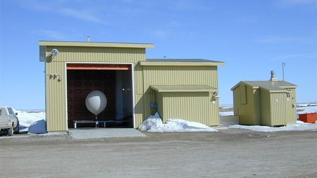
A weather balloon is prepared for launch in Nunavut, Canada. (CambridgeBayWeather/Wikimedia)

This balloon data is also used in forecast models. Before models are run, the sounding data provides an initial picture, or "initial conditions," of the current state of the nation's weather. Losing balloon data could mean gaps or erroneous information in the model output, which could affect forecasting. While not a major issue at the moment, new materials are difficult to come by.
“Apparently, getting supplies to do the sounding involves some bureaucratic finesse,” Sobien explained.
Sobien also revealed that preventative maintenance on all radars and automated weather stations sites, called ASOS stations, have been halted.
As of Thursday morning, Sobien said “flight critical ASOS freezing rain sensors are out-of-service at 36 eastern region airports.” Some of the larger airports include Baltimore-Washington International in Baltimore, Reagan National and Dulles International in Washington, D.C., Newark Liberty International in New Jersey, and LaGuardia and John F. Kennedy International in New York.

National Climatic Data Center

The National Climatic Data Center in Asheville, N.C. houses hundreds of millions of archived weather observations, from surface readings to upper air sounding data to offshore buoy data. The NCDC is a one-stop shop for weather information, recorded from decades ago until at least Sept. 30, the final day before the shutdown.
The government access to that data has now been severed, limiting meteorologists' ability to compare and contrast historical data with current conditions and future forecasts. Typically, at the beginning of the month, the NCDC will release an assessment of the previous month’s climatology. So far, that has not been the case in October.
Previous climatological events could help meteorologists be better informed about how an upcoming event, especially winter storms, might develop. Shutting down access to this critical data hampers meteorologists' ability to develop accurate forecasts.

Weather Model Developers Sent Home

Weather models are some of the most important tools for forecasting weather. Upper air and sounding data, in addition to surface observations and satellite data, are put into a computer model that then produces weather predictions.
GFS Model Data

GFS Model Data

The image above shows model output from the Global Forecast Systems (GFS) computational model.

But according to a recent blog post by Dr. Marshall Shepherd, professor of atmospheric science at the University of Georgia and current president of the American Meteorological Society, the furloughing of NOAA atmospheric science experts, who update and enhance these models, could cause delays in the rollout of the improvements.
“If the shutdown persists, it would be hard not to wonder if some improvement is being delayed that could save a life in 2015,” Shepherd said.

National Aeronautical and Space Administration

The nation’s space agency, NASA, not only launches rockets with satellites and payloads bound for the International Space Station, but it also provides invaluable satellite data that many meteorologists use.
However, as of Oct. 1, 97 percent of NASA's employees have been furloughed, leaving some to speculate that the shutdown could affect the timeliness and continuity of satellite data. Shepherd also hit on the issues NASA has had with data delays and gaps even before the shutdown.
“If the shutdown persists, I would imagine that this adds to the potential for delays or a gap,” he wrote.
While some of NASA's missions like the Asteroid Watch, Mars Rover and Cassini are still operating, their staff aren't active on social media, as they normally would be.

Lake Erie Algae a Threat to Drinking Water

John SeewerPublished: Oct 14, 2013, 8:58 AM EDTAssociated Press
 
 
TOLEDO, Ohio — Toxins from blobs of algae on western Lake Erie are infiltrating water treatment plants along the shoreline, forcing cities to spend a lot more money to make sure their drinking water is safe.
It got so bad last month that one township told its 2,000 residents not to drink or use the water coming from their taps.
The cost of testing and treating the water is adding up quickly — the city of Toledo will spend an extra $1 million this year to combat the toxins while a neighboring county is considering a fee increase next year to cover the added expenses.
Algae blooms during the summer and early fall have turned the water into a pea soup color in recent years. The unsightly surface has scared away tourists, and toxins produced by the algae have contributed to oxygen-deprived dead zones where fish can't survive.
The toxins also are a threat to the drinking water that the lake provides for 11 million people.
The annual algae blooms have been concentrated around the western end of Lake Erie — though a few have spread to the Cleveland area — and have affected water treatment plants in Toledo and other cities that dot the water's edge in northern Ohio.
The algae growth is fed by phosphorous from farm fertilizer runoff and other sources, leaving behind toxins that can kill animals and sicken humans.
Tests on drinking water in Carroll Township, which is just west of Toledo, showed the amount of toxins had increased so much in early September that officials decided to order residents to stop using the water for two days until they could hook up to another water supply.
It was believed to be the first time a city has banned residents from using the water because of toxins from algae in the lake.
"I wasn't sure how dangerous it was, but we wanted to be cautious," said Henry Biggert, the township's water plant superintendent.
The township's treatment plant is now back online, but the water is being filtered and treated over a longer period to remove the toxins, he said.
(MORE: 7 Mostly Awful Climate Change Winners)
What makes combating these toxins a challenge for operators of water treatment plants is that there are no standards on how to handle the problem or federal guidelines on what is a safe amount in drinking water. Plus, each water treatment facility is unique.
Plant operators along the lake in Ohio have been teaming up to figure out what works best.
We can throw a little more money and defeat it for a while.
David Leffler, Toledo commissioner of plant operations
"We're out there scrambling around," said Kelly Frey, Ottawa County's sanitary engineer. "It's just been do the best you can."
The county, he said, tests the water three times a week while adding a chemical called activated carbon to absorb the algae before filtering it. The expense of treating the water may require an increase in water rates next year of a couple of dollars a month for the average family, Frey said.
Toledo officials anticipated spending $3 million this year to treat its water, but the cost increased to $4 million because it has needed more chemicals to treat the toxins from the algae. That's about double what the city spent just a few years ago.
"We can throw a little more money and defeat it for a while," said David Leffler, the city's commissioner of plant operations.
But the larger issue, he said, is how to cut down on the amount of phosphorus from farm fertilizer and other sources that run off into the lake and feed the algae blooms.
His biggest fear is that the toxins could overwhelm Toledo's treatment plant and force officials to shut down its water supply to the state's fourth largest city and its suburbs. "It keeps me up at night," he said.
 

Wednesday, September 11, 2013

Hurricane Humberto ruins shot at a 2013 record

By Ed Payne, CNN
updated 7:42 AM EDT, Wed September 11, 2013
 
(CNN) -- Missed it by that much!
In a year that forecasters said there would be a few more hurricanes than normal, Humberto on Wednesday fell just a few hours short of setting a record for the latest first hurricane to form in the Atlantic Ocean. Usually, at least one hurricane would have formed in the area by this time in hurricane season.
All that it had to do was wait until after 8 a.m. ET, but alas, no. Three hours ahead of that mark, the National Hurricane Center in Miami dubbed it a legitimate storm with sustained winds of a 75 mph, the threshold for a hurricane.
But it's not likely to cause much of a fuss. Early Wednesday, it was about 310 miles west-northwest of the Cape Verde Islands, off Africa's coast. It's expected to fizzle into a tropical storm over the weekend.
Back in May, the National Oceanic and Atmospheric Administration Climate Prediction Center said higher-than-average water temperatures were expected to help yield a few more Atlantic hurricanes than usual.
Between 13 and 20 named storms and seven to 11 hurricanes were predicted. Humberto is the eighth named storm of the year and, again, just the first hurricane.
For the Atlantic Ocean, a normal season would produce 12 named storms, including six hurricanes and three major ones.
There's still time, if you're rooting for more hurricanes. Hurricane season, which began on June 1, runs until November 30.

Yosemite Fire Example of How Droughts Amplify Wildfires

The massive Rim Fire near Yosemite National Park in California is an example of how drought can amplify wildfires in a warming, drying West.
The fire, which now ranks as the 14th-largest wildfire in state history, has been racing through parched stands of oak and pine trees, and threatening some of the region’s iconic giant sequoia trees. The vegetation in the area, and indeed across much of central and southern California, is extremely dry, as the state has experienced its driest year-to-date.
The Rim fire burning in central California, near Yosemite National Park.
Credit: NASA.

California received a record-low 4.58 inches of precipitation during the January-to-June time period. That total was 1.69 inches below the previous mark, set in 1898, according to the National Oceanic and Atmospheric Administration, and nearly 10 inches below average.
A wetter-than-average July in California did little to alleviate drought conditions. Because the state typically receives very little rainfall during the summer, even light amounts of rainfall can push totals above average without putting a dent in the drought.
To make matters worse, a major heat wave in July helped further dry out soils, making forests primed for fire.
Parts of the West have been warming faster than the rest of the lower 48 states since the 1970s, a trend tied to climate change as well as natural climate variability.
Anthony Westerling, a climate scientist at the University of California at Merced who studies how climate change effects wildfires, said that increasing temperatures promotes evaporation, which leads to more frequent instances of “extreme fire conditions.”
“We have a lot of background variability from year to year and decade to decade in precipitation and rain and snow,” Westerling said. “But that (increasing) trend in temperature means that you have more evaporation” throughout the seasons, which is “really is exacerbating the natural drought periods.
“These really extreme fire conditions with very, very low fuel moistures become that much more likely over time, even without any change in the frequency of low precipitation years.”
A look at the Rim fire's growth since last Wednesday.
Click image to enlarge. Credit: ABC7News via Twitter

The current tinderbox that is the Central Sierra Nevada Mountain range can be traced back to the winter, when precipitation suddenly cut off.
“This last year we were seriously low on our snowpack in this part of the central Sierra Nevada,” Jerry Snyder, a Stanislaus National Forest spokesman, told Climate Central. The thickness and water content of spring snowpack and the timing of spring snowmelt, in particular, can influence wildfire risk during the summer. “We were only about 58 percent of normal, which meant that things dried out a lot sooner.”
Jeanine Jones, an interstate resource manager with California’s Department of Water Resources, said record precipitation during the first part of the 2012-13 winter helped bolster statewide water supplies enough to allow California to avoid serious water supply concerns this summer. The dry second half of the winter, though, contributed to the state’s wildfire woes, Jones said.
After January, “the faucet shut off,” Jones said. Such a bipolar winter, with little spring snow, may be a sign of winters to come in a changing climate, she said.
Jolyne Lea, a hydrologist with the National Water and Climate Center, said some weather stations at high elevations in the Sierra Nevada Mountains had near record low snowpacks during the 2012-13 winter.
As an example of how little snowpack remained this spring, according to Snyder, summer recreation in some parts of the Stanislaus National Forest began in June, a full month earlier than normal.
Percent of average precipitation so far this year in California.
Credit: NOAA.

“Early snowmelt dried things out significantly all across the forest,” Snyder said. A July heat wave, brought multiple 100°F-plus days to the Stanislaus forest. (That same heat wave caused Death Valley, Calif., to come close to tying its record for the hottest temperature recorded on Earth) “That helped further dry things out,” and pushed fire weather danger very high due to the abundance of very dry vegetation, Snyder said.
“There’s lots of stuff out there available to burn and conditions are right for it, so we’re having a really serious problem trying to corral this fire,” he said.
The conditions that have contributed to the explosive growth of the Rim Fire have become more common across much of the West in recent decades.
In the western states, including California, years with above-average temperatures, reduced spring snowpack, and early snowmelt tend to be years with bigger, longer-lasting fires. Research has also shown a general shift in forest fire ecology across the West, with a significant increase in the number of large, long-duration wildfires in many areas starting in the mid-1980s, a trend that has been attributed to a combination of climate change, land use change, and shifting fire suppression strategies, among other factors.
In the mountains of the Sierra Nevada in particular, decades of government policies to extinguish many natural wildfires rather than letting them burn themselves out have led to a buildup of vegetation, or "fuels," for today's fires to burn. "We do regularly suppress fires allowing only a few natural starts to burn along with prescribed burning for resources benefits," Snyder said. According to data Snyder provided, there were at least five large wildfires since 1973, including the Tuolumne Fire in 1987, which killed a firefighter and was the previous record holder for the largest wildfire in the Stanislaus National Forest.
History of large wildfires that burned in the same area as the Rim Fire.
Click image to enlarge. Credit: U.S. Forest Service.

There are more large fires (greater than 10,000 acres) burning now than at any time in the past 40 years, and the total area burned each year has also increased. The top eight worst wildfire years since 1960, in terms of acres burned, have all occurred since 2000, according to NIFC data.
According to Climate Central research, in some states, such as Idaho and Arizona, the number of large fires burning on U.S. Forest Service land each year has tripled or even quadrupled since the early 1970s. In other states, such as California and Wyoming, the number of large fires has doubled.
The Rim fire is one of 36 large fires burning across the U.S. as of Tuesday, and firefighting resources are stretched so thin that the nation’s wildfire readiness is at its highest level in five years.

However, the number of wildfires and acres burned to date are not unusual in the context of the past decade. So far this year, there have been about 33,000 wildfires in the U.S., according to NIFC data, with 3.5 million acres burned. That compares to a 10-year average of 54,000 fires by this point in the year, with about 5.8 million acres burned. The problem firefighters are facing is that so many large fires have erupted at the same time.
Many factors are involved in creating conditions that are primed for large wildfires. In addition to warming temperatures and changing snowpack trends, decades of fire suppression strategies have left large tracts of forest with excess fuel to burn. Increased human development near traditionally fire-prone ecosystems has contributed to an uptick in damaging fires, and natural climate and weather variability plays a large role as well.
Researchers predict that the area burned in the West may quadruple for every additional 1.8°F of average surface temperature rise. That is particularly ominous, since according to the most recent climate model projections contained in the draft U.S. National Climate Assessment, average temperatures could rise between 2°F and 4°F across most of the U.S. within the next few decades, and by as much as 8°F by 2100. The assessment, along with other studies, have projected an increase in drought frequency and severity in parts of the West, particularly the Southwest, which has benefited from an active summer monsoon season this year.