Showing posts with label Carl Brandon. Show all posts

Tuesday, April 16, 2013

Risk of Flooding from Missouri to Michigan

Last year, much of the Midwest was bracing for a rough ride with building heat and drought.
The year before, the story was record-challenging flooding.
This year, concerns have again flipped to flooding. Areas with an ongoing or developing flood potential extend from portions of northern Arkansas and Missouri to Michigan.
Late winter and early spring storms have made up for snow and rain deficits, pushing streams to bank full and have major rivers running well above their near-record lows from the start of the year.


Read more: http://www.foxnews.com/weather/2013/04/16/risk-flooding-from-missouri-to-michigan/#ixzz2QewXaZ8e

Strong Storms Louisville to Pittsburgh


A zone of thunderstorms, centered over the Ohio Valley, can be locally strong and gusty Tuesday evening.
The storms bring the risk of frequent lightning strikes, locally gusty winds, hail and brief downpours that can cause urban flooding.
Cities in the path of the locally heavy, gusty storms include Louisville, Indianapolis, Evansville, Cincinnati, Dayton, Columbia, Youngstown and Pittsburgh, as well as Wheeling and Morgantown, W.Va.


Read more: http://www.foxnews.com/weather/2013/04/16/strong-storms-louisville-to-pittsburgh-tuesday-evening/#ixzz2QewAdiOE

Tuesday, April 9, 2013

Tornado Risk Dallas to Kansas City and Others


As a storm moves out of the Rockies, the risk of violent thunderstorms, some capable of producing a tornado, will progress slowly eastward across the Plains Tuesday and Wednesday.
The storms will threaten lives and property and bring the risk of power outages and travel delays.
The first storms erupted Sunday in portions of Kansas and Missouri, but they were merely a small preview of what is expected to unfold this week over the middle of the nation.
The storms have the potential to cross through some or all of these major metropolitan areas over the Plains and Mississippi Valley, including Austin, Dallas, Houston, Kansas City, Little Rock, Memphis, Oklahoma City, Omaha, San Antonio, Shreveport, Springfield, Mo., Springfield, Ill., St. Louis, Topeka, Tulsa and Wichita.
The storms will bring the full spectrum of severe weather ranging from large hail and damaging wind gusts to flash flooding and frequent lightning strikes. There is also the potential for the storms to produce strong tornadoes into Tuesday evening.


Read more: http://www.foxnews.com/weather/2013/04/08/tornado-risk-dallas-to-kansas-city-and-others/#ixzz2Q02zb5EJ
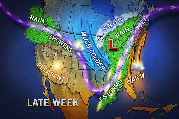
Spring storm heads toward Wyoming, Colorado


Snow is starting to fall in parts of central and western Wyoming, and forecasts for snow and high winds have parts of Colorado bracing for snowdrifts of 2 to 3 feet through Tuesday night.
The National Weather Service says the spring storm could bring 6 to 11 inches of snow through Tuesday in some areas, including Denver International Airport.
The temperature at the airport was 70 degrees at midday Monday before the storm arrived.
In Wyoming, a winter storm warning includes the cities of Cheyenne, Laramie, Rock Springs, Casper, Rawlins, Riverton and Lander.


Read more: http://www.foxnews.com/weather/2013/04/08/spring-storm-packing-several-inches-snow-strong-wind-gusts-heads-toward-wyoming/#ixzz2Q02RsiRv

Tuesday, April 2, 2013

South to Get Needed Rain, Unwanted Flooding Risk


A storm system developing over Texas will spread a zone of cool, drenching rain, thunderstorms and the risk of localized flooding across the South this week.
The rainfall can foil some outdoor plans, could slow travel on area highways and lead to sporadic flight delays at airports from Houston to Atlanta and Charlotte.
The early stages of the system will be realized as Texas and Oklahoma style thunderstorms into Monday night in portions of the states of the same name.


Read more: http://www.foxnews.com/weather/2013/04/01/south-to-get-needed-rain-unwanted-flooding-risk/#ixzz2PKk1hP8h

Severe Storms Threaten Texas, Oklahoma and Florida


Following a round of severe storms from Texas to Georgia on Easter Sunday, potentially damaging thunderstorms are expected to fire across portions of the U.S. on Monday afternoon and evening.
There will be two separate thunderstorm risk areas, including one in the southern High Plains and the other in southeastern Florida.
Plains Severe Risk
A storm will reach western Texas by the afternoon, igniting thunderstorms across the Texas Panhandle and southwestern Oklahoma. Enough moisture will arrive by the afternoon to support the growth of severe storms.


Read more: http://www.foxnews.com/weather/2013/04/01/severe-storms-threaten-texas-oklahoma-and-florida/#ixzz2PKjRd64H

Monday, March 25, 2013

storm brings heavy snow, baseball-sized hail


A major early spring storm brought heavy snow, severe thunderstorms and floods as it moved east across the United States on Saturday, closing highways, forcing flight cancellations and causing a pileup involving dozens of vehicles.
The weather system forced the cancellations of more than 100 flights in and out of Denver International Airport on Saturday and blowing and drifting snow closed several roads in Colorado, including Interstate 70 in both directions east of Denver to the Kansas state line.
"Travel on the eastern plains is strongly discouraged," said Mindy Crane, spokeswoman for theColorado Department of Transportation. "It is snowing half an inch an hour with sustained winds of 25 miles an hour with gusts up to 40 miles an hour."
A chain-reaction crash involving some 50 vehicles and at least four tractor-trailers shut down Interstate 25 about 30 miles north of Denver for several hours on Saturday, the Colorado State Patrolsaid in a statement. A tanker involved in the accident burst into flames.
http://news.yahoo.com/severe-u-storm-bring-heavy-snow-possible-tornadoes-164536444.html

Midwest Sees Spring Transform Into Winter Weather


Few signs of spring are being found in parts of the Midwest as a snowstorm tracks eastward mostly along Interstate 70, bringing heavy snow and high winds.
Two people killed in weather-related crashes were identified, dozens of Palm Sunday services were cancelled throughout Missouri, and about 100 flights were scrapped at Lambert Field in St. Louis. Winter storm warnings and advisories have been issued for Sunday and Monday as far east as Pennsylvania.
The storm dumped 7 to 9 inches of snow from eastern Kansas into central Missouri before tapering off Sunday morning, said Dan Hawblitzel, a meteorologist with the National Weather Service in suburban Kansas City.
http://abcnews.go.com/US/wireStory/midwest-sees-spring-transform-winter-weather-18803389#.UVChPI6hClI

Tuesday, March 12, 2013

Tropical Cyclone Sandra Roiling Australia Beaches


Tropical Cyclone Sandra weakened significantly on Tuesday, markedly lowering the threat of damaging weather to nearby New Caledonia.
At the same time, high swells radiating outward from the storm were bringing rough surf and rip currents, a phenomenon that was expected to persist through at least Thursday, to some beaches on faraway Australia's east coast.
Sandra was tracking southward over open seas west of New Caledonia, as it was aimed for the transition from the warm Coral Sea to the cooler Tasman Sea. Further weakening at sea was thus in the offing.


Read more: http://www.foxnews.com/weather/2013/03/12/tropical-cyclone-sandra-roiling-australia-beaches/#ixzz2NLzVsM00

Winter Precipitation Helped Some in Drought

Winter precipitation amounts caused national drought levels to drop from 57.7 percent to 54.2 from January to February. Winter wheat crops in the Southern Plains benefited from a few late-season snow storms that impacted the country in recent weeks. Wichita, Kan., saw its wettest February on record with 21.2 inches of snow. More than half of that amount, 14.2 inches, came from one storm that shut down airports on Feb. 21. Amarillo, Texas, also saw a surprising amount of snow, receiving 19 inches in one day.

Overall, the continental 48 had the 15th largest amount of seasonal snow cover for the 1966-present record with 127,000 more miles of coverage than the 1981-2010 average. Several states saw one of their top ten wettest winters, including Michigan, Wisconsin, Illinois, Mississippi, Alabama, Georgia, and Louisiana. Massachusetts brought in its eighth wettest winter, and Rhode Island had its third. Alaska had 32 percent above its normal precipitation amounts. These above-average rain and snow amounts were seen across the Upper Midwest down to the Gulf Coast, with some of the biggest impacts in New England and the Central Plains.


Read more: http://www.foxnews.com/weather/2013/03/12/winter-precipitation-helped-some-in-drought-may-hurt-others/#ixzz2NLzEdCK6

Wednesday, March 6, 2013

Weather Slows Navy Salvage Operation

Stormy weather in the Sulu Sea has once again slowed salvage operation on the wreck of the USS Guardian. The mine countermeasures ship ran aground on Tubbataha Reef on Jan. 17. The reef is a Philippine national park and World Heritage Site. The ship's crew was successfully evacuated and salvage ships rushed to the area. The sensitive nature of the reef and periodic bad weather has forced the piecemeal dismantlement of the ship and the use of a crane to lift the pieces away from the reef.


Chicago Winter Has Arrived Full Force


A snowstorm dropped a record-breaking 9.2 inches of snow in Chicago on Tuesday. The old daily record breaking snowfall for March 5 was 3.8 inches and was set in 1999.
So much snow fell that travel was impacted, causing 460 arriving flights and 422 departing flights to be canceled at the O'Hare International airport. Chicago Midway International airport had 131 arriving flights canceled and 128 departing flights canceled, according to FlightAware.com.
The 9.2 inches of snow contributes to the Windy City's current snow total of 26.3 inches through March 6, according to Climatology Supervisor Jim Piro. A complete snow season is measured from July 1 through June 30 of the following year.


Read more: http://www.foxnews.com/weather/2013/03/06/chicago-winter-has-arrived-full-force/#ixzz2MnpSMUYD


Wednesday, February 27, 2013

Tuesday's Record-Breaking Snow in Chicago


The 4.8 inches of snow for the day at O'Hare broke the previous record snowfall for Feb. 26 in Chicago, a record set in 1935. The National Weather Service Office in Chicago recorded 2.2 inches of snow, and Midway Airport picked up 3.6 inches.
With 14.1 inches so far at O'Hare and 8.7 inches of snow so far at Midway this month, the storm also made February a top-20 snowiest February in Chicago.
Tuesday's snow total at Rockford, Ill., was 4.1 inches, so only 0.2 of an inch more of snow needs to fall to make February 2013 a top-five snowiest February for the city.


Read more: http://www.foxnews.com/weather/2013/02/27/tuesday-record-breaking-snow-in-chicago/#ixzz2MA1uTwuW

Cyclone loses power after crossing Western Australia


A major storm has missed Australia's major iron ore port and crossed a sparsely populated stretch of the west coast.
The Bureau of Meteorology said in a statement Thursday that Cyclone Rusty was weakening as it tracked inland from the coast of Western Australia state but remained destructive with gusts up to 125 kph (78 mph).
Port Hedland was relatively unscathed by the storm that was gusting up to 230 kilometers (140 miles) per hour late Wednesday as it crossed the coast from the Indian Ocean to the south of the town.
Port Hedland residents were returning to their homes from storm shelters on Thursday after the bureau declared the danger there had passed. The iron ore export facilities were shut down on Wednesday for fear of damage.


Read more: http://www.foxnews.com/world/2013/02/27/cyclone-loses-power-after-crossing-western-australia-cost-missing-major-iron/#ixzz2MA1TAXeK


Tuesday, February 19, 2013

Blizzard to Slightly Ease Wheat Belt Drought


The storm forecast to bring windswept snow and blizzard conditions Wednesday and Thursday will bring needed moisture to drought-stricken winter wheat and corn areas, as well as other agriculture over a large part of the Plains.
The storm is projected to bring a general 6 inches to 1 foot of snow over a large area of the central Plains from northwestern and north-central Kansas to much of Nebraska, southeastern South Dakota and much of Iowa.
http://www.accuweather.com/en/weather-news/blizzard-to-aid-wheat-belt-dro/6460438

System could bring blizzard to Plains


A storm system in the western United States is expected to pose a triple threat to the country over the next three days, eventually bringing snow to the Southwest, a blizzard to the central Plains, and severe storms to Texas, Louisiana, and Arkansas, according to CNN's weather unit.
Portions of California, Nevada, Arizona, New Mexico and Colorado, especially those at higher elevations, face winter storm conditions over the next 24 hours.
Higher terrains in central and southern California could receive 4 to 6 inches of snow, with higher amounts possible in the Sierra Nevada range. Parts of eastern Nevada could get about 6 to 8 inches, and 8 to 10 inches are possible across central Arizona.


http://www.cnn.com/2013/02/19/us/weather-forecast/index.html?iref=allsearch

Tuesday, February 12, 2013

Workweek Snow for Southern Plains, Northeast

The next weather disturbance, currently over the southern High Plains, will spread east Tuesday and Tuesday night bringing accumulating snow from eastern New Mexico to the Ozarks.

By Tuesday, travel on Interstate 40 from east of Albuquerque into the Texas Panhandle and Oklahoma, as well as Interstate 35 andInterstate 44 in Oklahoma will likely be affected.

One factor working in motorists' favor will be temperatures and winds. With readings not far from the freezing mark, the snow will probably be a fairly wet snow, and roads may be more slushy than solid ice during the daytime hours. Northeast winds of generally 10 to 20 mph won't be enough to cause a lot of blowing and drifting with this type of wet snow.
http://www.weather.com/news/weather-winter/southern-plains-northeast-snow-20130211

Northeast digs out after deadly blizzard


The waves up to 30 feet high that climbed over houses thankfully are now a memory, as are related floodwaters that covered one quarter of one seaside Massachusetts town. Some streets that had been littered with trees and about 2 feet of snow are finally passable. And by late Monday morning, temperatures should rise well above freezing, perhaps accompanied by rain.
That's the good news. But it's still hard for scores of people still in shelters, and for many more huddling for heat overnight, to celebrate.
"It looked like a war zone," said Jim Cantwell, a state representative for the Bay State towns of Marshfield and Scituate, where about 90% of customers remained without power late Sunday. "The devastation we have seen here would lead one to believe that it'll be days before we get power back."
http://www.cnn.com/2013/02/10/us/weather/index.html?hpt=hp_inthenews

Tuesday, February 5, 2013

Chicago Sees Biggest Snow This Season


Early morning snow slowed traffic and delayed inbound flights to Chicago as plows tackled one of the area's first snowfalls of the season.
Though the light to moderate snow tapered to flurries by 6:30 a.m., another 1 to 2 inches was left behind Monday morning. That brought traffic to a stand-still in some spots on Chicago tollroads, and as of 7:30 a.m., at least 25 crashes were reported. At O'Hare International Airport, some flights were delayed an average of an hour and 32 minutes.


Source:http://www.nbcchicago.com/weather/stories/Chicago-Snow-Commute-189636841.html#ixzz2K3tVNe00

Snow, Ice Could Affect Evening Commute


A fast-moving band of snow could affect Tuesday evening's commute.

The National Weather Service at about 1 p.m. issued an alert indicating that snow could fall at a rate of 1-inch to 1.5 inches per hour for about two hours.  "Motorists should be alert for deteriorating visibilities and the possibility of slick conditions on 
roadways this afternoon," meteorologists said in a statement.


Source: http://www.nbcchicago.com/weather/stories/chicago-weather-snow-commute-189887561.html#ixzz2K3svxgrp