Showing posts with label David LeBreton. Show all posts

Tuesday, April 21, 2015

El Niño Is Hanging On: What that Means for Hurricanes

Over the next few months, the globe might see an uptick in tropical cyclone activity thanks to an El Niño that is showing signs of asserting itself more forcefully.That doesn’t mean more hurricanes everywhere, though: While El Niño tends to boost activity in the Pacific Ocean, it clamps down on storm formation in the tropical Atlantic. That link has at least one hurricane forecaster calling for a very quiet Atlantic hurricane season this year — possibly the quietest since the mid-20th century.
While El Niño is a cyclical climate phenomenon in the Pacific Ocean — marked by warmer ocean temperatures in the tropics and a weakening of the usual easterly trade winds — it can impact weather around the globe. During an El Niño, a domino of atmospheric effects causes a large area of stable, subsiding air to form over the tropical Atlantic. Exactly the opposite of what a fledgling tropical cyclone, which thrives on instability, needs to grow and strengthen. El Niño also tends to bring more wind shear to the region, meaning the speed and direction of the wind changes more between different altitudes, putting the kibosh on a burgeoning storm.
In the Pacific, it’s a different story: There, tropical cyclone activity ramps up during El Niño events. That doesn’t necessarily mean more storms, said Philip Klotzbach, a hurricane researcher at Colorado State University; instead, it might just mean storms form in areas that leave them with plenty of ocean to traverse before they peter out (and can shift the areas more likely to be hit by storms). Such longer-lasting storms are something frequently seen in the Pacific during an El Niño, Klotzbach said. Forecasters combine the strength of a storm and its duration into a measure called Accumulated Cyclone Energy, or ACE, which can be used to gauge the impact of a single storm or a season’s worth of them. Stronger, longer-lasting storms have higher ACE values.
In an El Niño year, fewer Atlantic storms mean a lower ACE for that basin, while in the eastern and northwest Pacific, longer-lasting storms raise the ACE value. But the changes aren’t equal: The increase in Pacific activity is larger than the decrease in the Atlantic, so “your global activity actually increases in El Niño years,” Klotzbach said.In particular, activity in the northwest Pacific is a big determinant of global ACE for a given year. There, the tropical cyclone (or typhoon, to use the regional term) season lasts virtually all year, and so there is more opportunity for storms to form. The tendency towards El Niño-like conditions last year still boosted Pacific activity and tamped down on the Atlantic. Several storms reached Hawaii, while Japan saw several landfalls — other signatures of El Niño-year activity. The global ACE value was also higher than in the previous two years, when neutral conditions were in place.
Klotzbach thinks that ACE “should actually be high this year,” though he expects only seven tropical storms to form in the Atlantic, compared to the average of about 12. Of those, his forecast calls for only three to become hurricanes, compared to an average of six.

http://www.weather.com/science/news/el-nino-strength-what-that-means-for-hurricanes

Australia Storm Hammers Sydney, New South Wales; Flooding Washes Away Homes


A slow-moving storm has hammered parts of eastern Australia's New South Wales province with damaging winds and destructive flooding.The BBC reported that three people were found dead in the town of Dungog. Homes were swept away as over 12 inches (312 millimeters) of rain in just 24 hours swamped the town of about 2,100 residents 135 miles north of Sydney, according to the Australian Bureau of Meteorology (BoM).New South Wales Fire and Rescue ushered four people trapped in a flooded home and local government urged residents of Dungog to evacuate to a local high school, if possible, due to the severe flooding.
Numerous locations near the coast in New South Wales picked up another 100 millimeters – just less than 4 inches – of rain since 9 a.m. local time Tuesday, on top of heavy rainfall from Monday. The BoM continued flood warnings for stretches of eight rivers in the province, including the Williams River near Dungog. The East Coast low also battered the Sydney metropolitan area with an incredible 33 straight hours of sustained winds over 30 miles per hour and frequent gusts over 50 mph from mid-afternoon Monday through midnight Tuesday night. A peak gust to 83 mph was clocked at Norah Head and Wattamolla, according to the BoM.
The high winds downed trees, some onto homes, and knocked out power to 215,000 customers, the largest outage in the region in eight years, according to WeatherWatch. New South Wales' transport minister urged no unnecessary travel in the city of Sydney during the storm.These persistently strong onshore winds lead to significant coastal flooding and beach erosion, with local media reporting a 36-foot wave off the coast east of Sydney. The high winds whipped beach sand into drifts, trapping some vehicles at Sydney's famous Bondi beach, forcing closure of the popular beach destination.An estimated 7-8 inches of sand was blown off Sydney area beaches during the storm, a Surf Live Saving New South Wales spokesman told the Daily Telegraph. 
The culprit for these impacts was an area of low pressure aloft that became trapped to the north of the active jet stream. That trapping lead to the slow-movement of the storm.This closed-off upper-level low then induced a low-pressure center just off the New South Wales coast. The pressure gradient between that surface low and high pressure centered near Tasmania and the Tasman Sea lead to the intense onshore winds

http://www.weather.com/news/news/australia-storm-sydney-new-south-wales-flooding

Monday, April 13, 2015

Flash Floods Hit North Texas, Alabama


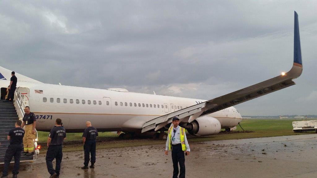
Heavy rain has descended on the South and the Gulf Coast, bringing localized flash flooding to both north and west Texas and stranding a handful of drivers on impassable roads. ABC 8 reports that Fort Worth roads started flooding Monday morning and rescue crews were dispatched to save drivers in submerged vehicles across the Dallas-Fort Worth Metroplex. In Saginaw, a suburb of Fort Worth, Texas, flash floods submerged local roads. Oncor reports that over 2,000 customers in the Dallas-Fort Worth Metroplex lost power by mid-morning. A United Airways flight made a hard landing in rainy weather at Bush Intercontinental Airport in Houston, Texas, before sliding into muddy grass off the runway. 
Mobile, Alabama, saw its fair share of flooding Monday morning, and, as AL.com reports, heavy rain led the sewer system to overflow across the city.
On top of the rain, lightning struck a major water main in Mobile last night, cutting off water service to local businesses and flooding roads in South Mobile County. In Macclenny, Florida, a woman and her daughter were taken to the hospital with non-life threatening injuries after lightning struck near the pair, First Coast News says. 
That same lightning strike caused a structure to catch fire, but no word is out on other impacts. 

View image on Twitter

http://www.weather.com/news/news/flash-flooding-heavy-rain-north-west-texas-alabama-gulf-coast

California Rain and Snow: Funnel Cloud Spotted Over Sacramento

Drought-plagued California has received multiple rounds of wet weather this week, but it's nowhere near enough to squash all of the thirsty state's drought issues.
The first storm rushed ashore on Sunday, bringing snow to some areas in the higher elevations and even reports of small hail in northwestern California. The pea-sized hail covered roadways and yards in several towns, according to the National Weather Service. A second wave came through Monday and Tuesday, bringing more much-needed rain and snow to the Golden State.
View image on Twitter
There was even some severe weather associated with the second wave, as a funnel cloud was spotted over Sacramento late Tuesday afternoon. Even though some areas in the higher elevations received more than a foot of snow, according to local storm reports, it's merely a drop in the proverbial bucket that's a years-long drought gripping the state.
Only one town recorded more than an inch of rain from this system; Grass Valley received 1.07 inches, but most areas saw far less, according to local storm reports. The storms also brought strong winds as high as 70 mph. While experts tell The Sacramento Bee the rain should be a small boost to some of the state's historically low reservoirs, it won't be enough to replenish the state's water deficit. The heaviest rain isn't expected to fall on southern California, where the reservoirs with the lowest water levels are located. The struggling ski resorts were eagerly hoping the forecast would pan out. Heavenly Mountain ski resort now believes it will have enough snow to stay open for at least two more weeks, according to a separate L.A. Times report. And at a time when the state's snowpack should be at its peak, 88 of the 123 spots where NASA measures for snow across the Golden State had no snow at all on April 1.
The coming dry season was one of many reasons for Gov. Jerry Brown's decision to order the first-ever mandatory water restrictions for the state last week.

http://www.weather.com/news/news/california-storm-rain-snow-impacts

Fairdale, Illinois, Tornado Receives Preliminary EF4 Rating, National Weather Service Says

The tornado that tore through northern Illinois Thursday night has received a preliminary rating of EF4 based on an initial ground survey of the most heavily damaged area, the National Weather Service reported Friday evening. The EF or Enhanced Fujita Tornado Intentisy Scale measures a tornado’s impact. The scale goes from 0 to 5, with 5 being a storm that causes incredible damage. An EF4 tornado brings with it windspeeds of 166 to 200 mph and causes “devastating” damage. Estimated peak windspeeds of Thursday’s tornado reached 180 to 200 mph. Earlier in the day Friday, local officials said they were confident everyone was out of the area. Kirkland Fire Department Chief Chad Connell said they brought in three K-9 teams as a “precautionary measure,” to “double check our work.

The area struck yesterday still has no power. Local officials said residents could come to assess the damage to their property on an “escorted basis,” but encouraged people not to stay around until conditions were proven safe. Gov. Bruce Rauner earlier in the day Friday declared Ogle and DeKalb counties disaster areas, making state resources available for the areas hardest hit by this storm, which took two lives. Geraldine M. Schultz, 67, and Jacqueline Klosa, 69, next-door neighbors, were both killed, and 11 more people were hospitalized after at least one tornado ripped through northern Illinois Thursday evening at about 7:15 p.m., officials said. Klosa’s body was found during a second search Friday morning, according to the Chicago TribuneEvery home in the community of 200 about 20 miles southeast of Rockford was affected by the storm, authorities said. After crews had a chance to survey the damage in the town, Connell estimated as many as 18 homes were completely swept off their foundations by the large twister.


http://www.weather.com/news/news/tornado-damage-seen-in-northern-illinois

Thousands Lose Power in Tennessee Friday Night; 1 Woman Killed By Falling Tree in Kentucky

Severe weather killed a woman and spawned multiple tornadoes across the Plains and Ohio Valley Thursday night and Friday.
Damage reports flooded in from Alabama and Tennessee, including reports of downed power poles and trees, a flipped truck and a possible fatality.A motorist was killed in Lauderdale County, Alabama, Friday night when their car left the road and struck a tree on Alabama 157, AL.com reported. Authorities are unsure if the storms are a factor and are investigating the incident. Over 3,000 Nashville Electric Service customers were without power Friday night because of the storms, according to the utility's website. Power was returned to most customers Saturday morning. 
Catherine Carlson, 45, was camping with her husband and three kids when a dead tree was blown onto their tent, killing her and injuring the man critically, the report added. Powell County coroner Hondo Hearne said the children didn't appear to be injured, The Associated Press reported. Several tornadoes were also reported in the Plains and Midwest Thursday, rattling the nerves of people across a four-state tornado watch area, including those in Joplin, Missouri, a city still recovering from an EF5 twister in 2011 that killed more than 150 people. According to Dr. Greg Forbes, weather expert, 12 tornadoes were reported across 4 different states Thursday, but some of those reports are unconfirmed until a survey crew determines damage in the area was actually caused by a twister. So far, the National Weather Service has confirmed four tornadoes in Missouri. To the north, Kansas reported more tornadoes than any other state Thursday night, with 5 of the 12 tornado reports coming in the Sunflower State

http://www.weather.com/news/news/tornadoes-reported-plains-oklahoma-missouri-kansas

Tuesday, April 7, 2015

Toxic Lake in Inner Mongolia Created By World's Addiction To High-Tech Gadgets

There's a place in China's autonomous region of Inner Mongolia where a lake of toxic sludge has been forming for years, and it's only there because of the technology boom.
It's happening in Baotou, the world's biggest supplier of rare earth minerals, according to Mining.com. There's a total of 17 elements, USGS says, that are mined and then used in the production of smartphones, tablets and even "green" technology, like wind turbines. A massive complex known as Baogang Steel and Rare Earth mines and manufactures the minerals, but that creates millions of tons of waste per year, and that sludge is dumped nearby in an area that used to be a river, according to the BBC. In all that sludge, a dirty little secret is hidden. To create our tiny gadgets, mining these rare earth minerals requires a process that isn't so environmentally friendly. Cerium, for example, is one of those elements, which is used in myriad products, BBC also reported. It's used to make catalytic converters and combined with oxygen to polish smartphone touchscreens, among many other purposes.
But the extraction process for cerium isn't exactly green. It requires that the minerals be crushed and then dissolved in sulphuric and nitric acid, BBC added, and when you consider the massive scale by which these minerals are mined and produced to satisfy our craving for technology, it's easy to see why there's so much sludge created. It's not only disgusting and harmful to the environment, it's been blamed for harming the health of nearby residents. The Want China Times reported in 2011 on the illnesses locals were suddenly experiencing, ranging from nausea and dizzy spells to arthritis and migraines when they drink the water. Livestock have died en masse, and some of the radioactive materials found in the mud have been tied to increased risk of several types of cancer, including leukemia, the report added.
And that's not the only fear plaguing residents. They also told The Want China Times that the dam built to plug up the river sits on a fault line, and if a major earthquake rattles it loose, there could be disastrous consequences downstream. Before the plant dammed up the river and began dumping sludge, the area was filled with rolling fields of crops that produced food for the area, according to a 2012 report by The Guardian. Now, those fields are gone, covered up by radioactive materials.


http://www.weather.com/science/environment/news/baotou-artificial-lake-toxic-sludge

The Future of Mountain Glaciers Is Bleak

Melting ice in Greenland and Antarctica get far more attention, but mountain glaciers around the world — in the Rockies, the Andes, the Himalayas and other ranges — are melting as well as the planet heats up. All told, say climate modelers, the water they release could contribute about a foot’s worth of the 3 to 6 feet of sea level rise projected by 2100.
But those models only describe the melting of glaciers in the broadest terms — as an aggregate. Just like projections for global temperature increases, those broad-brush descriptions of how glaciers will melt don’t offer much useful information to people who now depend on them for water supplies and hydropower. Now a team of scientists, writing in Nature Geoscience, is describing a new modeling technique that could provide that crucial information. By combining regional temperature projections with detailed maps of the underlying topography, then adding in the physics of ice flow, the authors project not only that the glaciers of Western Canada will lose at least 70 percent of their volume by 2100 — a number more or less in keeping with current projections — but show exactly how every individual glacier will shrink. “This allows you to answer questions like ‘what will it look like when you go to Banff, or Lake Louise, in 2100,” lead author Garry Clarke, of the University of British Columbia, said in an interview.
More important, it allows planners to see how water resources will likely change as the world continues to warm. Unlike the snowpack in the mountains of California, for example, which waxes and wanes significantly depending on annual precipitation, glaciers are semi-permanent fixtures that store enormous volumes of water, releasing some of it to streams and rivers during the summer. According to Clarke and his co-authors, the Columbia River alone, which is fed primarily by British Columbia glaciers, provides about 5 gigawatts of power to the Pacific Northwest, or enough to provide electricity to more than 3 million homes. The authors don’t address the consequences specifically, but it illustrates just one aspect of how warming could affect millions of people in that part of the world. The authors also made projections based on the optimistic and ambitious assumption that emissions peak in 2020, then decline. “In that case, many inland glaciers would shrink, but they wouldn’t disappear. That’s the good-news side of the equation,” Clarke said. But that’s considered highly unlikely, even with new pledges by the U.S. to cut emissions.


http://www.weather.com/science/environment/news/glaciers-bleak-future-2100-study

Tuesday, March 31, 2015

The West Coast Is in Hot Water

Move over polar bears. Are starving sea lion pups the new face of climate change?
This year’s slew of hungry pups washing ashore in California, which has generated a slew of media coverage replete with heart-tugging images, has roots in natural temperature fluctuations in the ocean. But in the coming decades, human-induced warming could make these types of conditions more common. And sea lion pups are just the tip of a larger shift in the Pacific and the rest of the world’s oceans if human emissions continue to warm the planet. In recent weeks, emaciated young sea lions have been washing up on California beaches. Roughly 1,800 stranded pups have been found on California beaches through the first two-and-a-half months of 2015. That’s well above the 100 or so that usually turn up through the end of March and “at least as high as anything in the historical record,” according to Nate Mantua, a scientist at the Southwest Fisheries Science Center in La Jolla, Calif.
In 2013 and 2014, large numbers of disheveled sea lion pups were also stranded on California’s beaches, though not at the same levels as this year. One of the main causes has been the unusual and in some cases, record setting — warm water off the West Coast of the U.S. and stretching all the way to the Gulf of Alaska. The warm water is less rich in nutrients and the types of microscopic organisms and fish upon which sea lions usually feed. That has forced sea lion moms and pups alike to forage further for food, a tiring proposition for young sea lions. While the sea lions have been the face of the recent intrusion of warm water, ecosystem disruptions are visible throughout the stretch of the eastern Pacific and Gulf of Alaska. Cold water copepods — small crustaceans at the base of the food chain — populations have dropped off sharply in the past year, while their warm water (less nutritious) brethren have shown up in huge quantities.
Further up the food chain, skipjack tuna have turned up in Alaska, thousands of miles beyond their usual range and Mantua said, “sportfish like marlin — things people travel to fish for in Baja — they’re catching them for day trips in southern California.”The warm water in the eastern Pacific over the past two years is a harbinger of things to come for the region. Ocean temperatures have been rising around the world and are expected to keep warming, and the eastern Pacific could see the odd conditions of the past two years become commonplace by mid-century. Just how far-reaching the impacts will be and which species will adapt and which will fail to is something scientists are still trying to untangle.


http://www.weather.com/science/environment/news/west-coast-hot-water-rising-temperatures-climate-change


Hawaii's Coastlines Will Erode Twice As Fast By 2050, Study Says

Hawaii's majestic coastline has always been molded by the sea, but a new study found a reason to be concerned about our 50th state's pristine beaches.
Scientists at the University of Hawaii's School of Ocean and Earth Sciences and Technology recently released a study that found some of the island state's beaches will be reduced by as much as 20 feet by 2050 and 40 feet by 2100 due to erosion. Their findings were published this week in the journal Natural Hazards.
The scientists came to their conclusions after studying 10 Hawaiian beaches on the islands of Oahu, Maui and Kauai. Of the three islands studied, Maui has the highest rate of erosion, with 85 percent of beaches affected. "Over a century of building along the Hawaiian shoreline, without this sort of detailed knowledge about shoreline change, has led to some development that is located too close to the ocean," said Dr. Charles Fletcher, UH Geology and Geophysics Professor and lead author of the study, in a USGS report." This is especially troubling, the university's Coastal Geology Group said, because building a seawall would actually accelerate the speed of erosion, so it isn't an option for the Hawaiian coastline.
There are multiple reasons why the state's coastline is eroding, and officials must now prepare a response to all of them. First and foremost, erosion can occur naturally; not all sand is replaced at the equal rate it's removed. But there's that other cause of erosion – rising sea levels – that scientists must now factor into their studies. It's one of the reasons why this study has such dire predictions for the future of Hawaiian beaches.


http://www.weather.com/science/environment/news/hawaii-erosion-new-study


Super Typhoon Maysak Devastates Micronesian Island, Threatens Philippines

Two days after causing widespread destruction in Micronesia, Maysak has intensified into a super typhoon and threatens the Philippines along with other island nations in the Western Pacific. 
Maysak struck Micronesia's Chuuk State on Sunday evening, demolishing up to 95 percent of tin houses on the island, according to Guampdn.com. The unofficial death toll varies, but some say at least five are dead. Communications systems on the island, which has a population around 50,000, were down this weekend, and the full extent of the damage caused by Maysak's battering winds and rain is still unknown. Yap, which is part of the Caroline Islands, and the Philippines are on track to feel Maysak, now the equivalent of a Category 5 hurricane, next. 
Guampdn.com reports that the Ayuda Foundation is already working to provide aid to Chuuk by filling up a 40-foot container with food and building materials for the island's residents. In a radio broadcast, Federated States of Micronesia public information officer Marz Akapito said that boats would arrive on Chuuk with water bottles and medical supplies. After Maysak passes Yap, other boats will conduct more thorough damage assessments. Chuuk locals use mango, banana and cocounut trees, many of which were pulverized by Maysak's winds, as a main source of food. Meanwhile, Yap is preparing for Maysak's impacts as the storm approaches with maximum sustained winds of 160 mph. 

http://www.weather.com/storms/typhoon/news/typhoon-maysak-impacts-chuuk-yap-philippines-guam-pacific

Tuesday, March 24, 2015

Reactivated Fault Lines Could Trigger Larger Oklahoma Earthquakes, Study Says

Residents of central Oklahoma have become familiar with the ground shaking in the last few years, but it could all lead to something bigger and more damaging, according to geologists. The findings of a new study, published recently in Geophysical Research Letters, reveals that thousands of small, shallow earthquakes along the state's strike-slip faults may have reactivated fault lines that are capable of major tremors. That's because the direction these fault lines are facing don't line up with the direction of regional tectonic stress in the planet's upper crust, increasing the probability of a large quake, the U.S. Geological Survey (USGS) says.

The study did not investigate whether hydraulic fracturing – better known as fracking – was causing the faults to be reactivated. 
Any larger earthquake could be worsened by the fact that building codes in Oklahoma aren't as strict as areas like California, Reuters reported. That's especially worrisome because there are as many as 12 fault zones capable of triggering a magnitude-5 or -6 earthquake. More than a dozen homes and multiple businesses sustained damage from a 5.6-magnitude temblor back in 2011. Last year there were 5,417 earthquakes in Oklahoma, and 585 of those quakes were magnitude-3 or larger, according the Oklahoma Geological Survey,

http://www.weather.com/news/news/oklahoma-earthquakes-fault-line

Ice Chunks as Big as Cars Leave Damage Near Toledo, Ohio

Ice chunks as big as cars have formed along the Maumee River in Toledo, Ohio, pushing the river well over its banks, cracking roads and even devastating an old cemetery that was the final resting place for Civil War soliders. Spring-like temperatures plunged into the Great Lakes region late last week, quickly weakening the icy layer that covered virtually everything. When the warmth hit, it seemed like the river thawed all at once, with huge chunks of ice breaking up. The hardest-hit stretch of the river is Side Cut Metropark and Riverside Cemetery, both in Maumee, Ohio. The cemetery was originally built in the 1800s, where some graves date back to the Civl War.


It's been decades since the Toledo area has seen a spring thaw this damaging. According to 13 Action News, the last time boulder-sized ice chunks pushed their way off the river onto nearby roads was 1982.
While the area is used to seeing a spring thaw, it's not always quite this impressive. Some photos show piles of ice stalked so high, it nearly reaches up a bridge wall to Interstate 475. The cleanup has started, but some riverside parks and roads remain closed. High temperatures across the region this week will range from the high 40s to the mid-50s with no precipitation in the forecast.


http://www.weather.com/news/news/huge-ice-chunks-toledo-ohio-maumee-river


Tuesday, March 17, 2015

Arctic Sea Ice Dwindling Toward Record Winter Low

While balmy hints of spring melt piles of snow in the eastern U.S., the impending end of winter marks peak season for Arctic sea ice. But this year, that winter maximum area is currently on track to hit a record low since satellite records began in 1979.
What that low-ice mark means for the spring and summer melting seasons is unclear, but the milestone would still be notable in the global warming-fueled cycle of Arctic sea ice decline.
“The fact that we're starting the melt season with low — maybe record low — winter extents cannot be good,” Jennifer Francis, a Rutgers University Arctic researcher, said in an email. Sea ice extent is crucial to the Arctic's ecology and economy, affecting wildlife habitats, weather patterns and shipping lanes. Sea ice is a key part of the habitats of animals like polar bears and walruses, as well as fish and other creatures that live below it. When it is missing, it can make it difficult for some of the animals to find food. For humans, ice-free areas of water are prime real estate for oil drilling and shipping, and an Arctic low on ice would open the region to more of both, a controversial proposition. There has also been research that indicates the disappearance of sea ice, along with the broader warming of the Arctic, is affecting weather patterns over North America, Europe and Asia, though there is still much work to be done to fully explain such a connection.
Global warming triggers a self-reinforcing downslide in the area the ice covers, as well as how thick the ice is. Warming Arctic temperatures triggered by the buildup of greenhouse gases in the atmosphere cause more ice melt, which exposes more of the open ocean. Whereas the bright white ice reflects the sun’s rays, the dark ocean absorbs them, causing even further warming and melt.
The average extent has declined by 4.52 percent per decade, according to the National Snow & Ice Data Center (NSIDC) in Boulder, Colorado. The summer minimum has declined even more steeply, by 13.7 percent per decade. This warming-driven cycle helped lead to 2012’s record low summer sea ice minimum, though what happens year to year is also driven by varying weather patterns. There’s a good chance sea ice area will stay at a record-low level as it begins its warm season retreat.

http://www.weather.com/science/environment/news/arctic-sea-ice-dwindling-record-low-levels

Cyclone Pam Flattens Vanuatu: Rescue Teams Report Devastation; Official Death Toll Lowered

Rescue teams and relief workers made their way to Vanuatu's outer islands Tuesday after days of struggling to reach the devastated archipelago's worst-hit areas. 
Aid from Australia and New Zealand is welcomed as Vanuatu's residents say they're running out of vital supplies.
"We are running short of food, water, shelter and electricity," resident Ropate Vuso told Reuters. With communications down and the islands in a scramble, officials were unable to gather accurate information. 
A death count from the U.N. was lowered to 11 from 24 Tuesday after officials realized they counted someone people twice, the Associated Press reports. At least 3,300 people in Vanuatu were left homeless Monday as aid began to arrive from nearby Australia and New Zealand, the U.N. confirmed. 
In Vanuatu's capital Port Vila, Oxfam Australia says that up to 90% of housing has been damaged, including vital supplies of food and water. Tom Skirrow, country director of Save the Children Australia, described the utter devastation in Port Vila to Reuters, "People are wandering the streets looking for help."
The full picture of Pam's impacts, including the final death toll, may not be known for what aid workers say may be days or even weeks. Now that Port Vila's airport has been reopened, military flights out of New Zealand and Australia are bringing in water and medical supplies to Vanuatu with contributions from France and the United States. 
Reuters reporters that Australia has also sent a medical assistance to Port Vila to assist the sparse teams already on the ground. 
According to the Associated Press, Port Vila's hospital was evacuated because officials feared the building could collapse. The Red Cross will be joined by The Pacific Humanitarian Team, UNICEF and UNHCR in its efforts to help those affected by Pam. Before slamming Vanuatu, Pam affected around 3,000 households in the nearby Solomon Islands and Kiribati, destroying homes and flooding crop areas, said the BBC. Pam also caused flash flooding in the island nation of Tuvalu.


http://www.weather.com/storms/hurricane/news/cyclone-vanuatu-impacts


Vanuatu President Baldwin Lonsdale Blames Global Warming for Devastation from Cyclone Pam

Vanuatu President Baldwin Lonsdale, whose country was devastated by Cyclone Pam this week, warns that climate change is contributing to more extreme weather conditions.
Speaking at a United Nations conference in Sendai, Japan, on Monday, Lonsdale said that 90 percent of buildings in the country's capital city, Port Vila, had been damaged or destroyed by the Category 5 storm, which delivered winds up to 150 mph. “It’s a setback for the government and for the people of Vanuatu,” he said. Lonsdale said the cyclone seasons the nation experiences are directly linked to climate change.
“We see the level of sea rise. ... The cyclone seasons, the warm, the rain, all this is affected,” he said. “This year we have more than in any year, ... Yes, climate change is contributing to this. The U.N. conference was where Lonsdale focused on disaster risk reduction. Lonsdale’s statements were echoed by Anote Tong, president of nearby Kiribati, also affected by the storm.“There will be a time when the waters will not recede," he said. Earlier this month, Port Vila was named the city most exposed to natural disasters by risk analysis company Verisk Maplecroft.
Leaders of Pacific island nations have repeatedly called for action on climate change in recent years, attributing the rising sea levels and intensified storms that threaten their countries to global warming.


http://www.weather.com/storms/hurricane/news/cyclone-pam-vanuatu-climate-change


Tuesday, February 17, 2015

Sandstorm Engulfs Middle East; Pollution Levels Highest in 5 Years

Saharan dust was picked up by a storm system and was carried hundreds of miles east, turning the air orange in several Middle Eastern countries over the past few days. The sandstorm was first seen in Egypt, blanketing Cairo for two consecutive days. On Wednesday, the sand moved over Israel and Lebanon, leading to some of the worst pollution in years and, when paired with gusty winds, forced some residents to walk backward to keep the grit off their faces. Strong winds from the system also brought large waves into Beirut's famous corniche along the Mediterranean Sea. A potent low-pressure system has been moving through the eastern Mediterranean Sea early this week," said weather.com meteorologist Chris Dolce. "Strong winds on the southern periphery of this storm helped to pull sand and dust from northern Africa across Egypt on Tuesday and points eastward from there."
Israel's Environmental Protection Ministry said air pollution levels were the country's worst in five years and the storm would last into Wednesday night. Israeli airports spokeswoman Liza Dvir said flights to and from the Red Sea resort city of Eilat temporarily were grounded due to the weather, though planes still flew through the country's main international hub, Ben Gurion Airport outside of Tel Aviv. On Tuesday, the strong sandstorm first reached Egypt, temporarily closing Cairo International Airport to incoming flights. The weather front also caused strong waves to crash into the coast and saw Egypt close two of its seaports. The sandstorm hit Egypt after unusually warm and sunny weather for a February day. Such sandstorms are common in Egypt this time of year.

http://www.weather.com/news/news/middle-east-sandstorm

Record-Breaking Western Warmth Brings Escape From Winter

If you are looking to escape from winter, head west. While parts of the East will see some of the coldest temperatures of the season and even in years in some cases, the West will experience record warm temperatures. A ridge of high pressure will keep temperatures warm from the Rockies to the West Coast through this weekend.Much of the West and even parts of the Plains have seen warm conditions so far this month with many record warm temperatures broken and more record-breaking warmth is on the way. High temperatures will be 10 to 20 degrees above average in many locations from the Rockies westward through Sunday. High temperatures will climb into the 50s and 60s as far north as Oregon and Washington state.It will feel like spring as well in Portland, Oregon, with highs reaching the upper 50s to low 60s through early this week. The average high temperatures in April are in the upper 50s and low 60s.
Friday, record high temperatures were set in Seattle (60 degrees), Casper, Wyoming(61 degrees), Butte, Montana (56 degrees), San Jose, California (77 degrees). On Saturday, Las Vegas tied their record high of 78 degrees, and Reno had its warmest Valentine's Day on record (as well as a record high) when the thermometer hit 72 degrees. Salt Lake City (60 degrees) and Pocatello, Idaho (56 degrees) broke their daily high temperature records. On Sunday, record highs may be broken in San Francisco (72 degrees), Albuquerque (70 degrees), Las Vegas (77 degrees) and Portland, Oregon (63 degrees). Phoenix has seen high temperatures in the 80s since Feb. 5, with the exception of this past Thursday which recorded a high of 78. This 80s stretch is expected to continue through at least early this week.
http://www.weather.com/forecast/national/news/west-warm-february-winter-escape

Winter Storm Octavia Shuts Down D.C. Area; Snow Could Slow NYC Commute

Winter Storm Octavia hit states along the Eastern seaboard starting through the night Monday and into Tuesday. A snow emergency went into effect in Washington, D.C. on Tuesday at 7 a.m. and federal offices are closed for all non-essential workers. The region remains under a winter storm warning until noon, and D.C. public schools have closed as well. Storm total accumulations are expected to exceed 6 inches across a swath of the Mid-Atlantic, particularly Virginia, Maryland and Delaware. New York City and Long Island commuters should expect hazardous travel conditions during the Tuesday morning rush hour. A winter weather advisory remains in effect for for the area until noon. Two to four inches of snow expected to fall by Tuesday afternoon, and wind gusts up to 20 mph are being forecasted. 
Before the worst of the snow, minor traffic accidents were reported across the Mid-Atlantic region, and thousands of flights were canceled. Amtrak announced a modified schedule for Tuesday between New York City, Boston, parts of Virginia and Washington D.C. because of Octavia impacts as well. In West Virginia, a train carrying crude oil derailed, leaking oil into a nearby river Monday afternoon and sending a fireball into the sky. The derailment prompted an emergency declaration for two counties and concerns over water quality. Although the accident has not been labeled weather-related, slick roads did affect local response. The Maryland Department of Transportation's State Highway Administration is still recommending that drivers try to avoid travel and stay off the roads, despite the winding down of snow on Tuesday morning. Cleanup operations will continue throughout the day to clear snow-covered roads across the state. A winter storm watch remains in effect for New Jersey since Monday evening through Tuesday morning. Schools have delayed the start of classes or closed for the day, and State government offices have also delayed their opening until 11 a.m. on Tuesday to give workers extra time to get in, reports The Associated Press. Public schools in Philadelphia and dozens of suburban districts have closed Tuesday as the winter storm hit, blanketing the region with 4 to 8 inches of snow. The city's Catholic Schools are opening two hours late.

http://www.weather.com/storms/winter/news/octavia-midatlantic-snow

Tuesday, February 10, 2015

Snowstorms and Floods Hammer Europe

Snowfall and heavy rain are hammering Europe and bringing deadly floods to the Balkans. Hundreds of families have been evacuated from their homes in Albania and one woman drowned after being swept away by floodwaters, the Associated Press reports. Snow continues to blanket parts of Italy and Spain, where hundreds of motorists were trapped on roadways. Two homeless people were killed after northern Spain was hit by a second wave of snow on Friday. The Associated Press reports that the persistent flooding in the Balkans has forced the evacuation of at least 600 families and killed thousands of livestock. In Croatia and Slovenia, heavy snowfall snarled traffic over the weekend and caused authorities to place travel bans on major roadways. Days ago, eastern Macedonia was placed under a state of emergency along with portions of Greece, Euronews reports. The BBC reports that travelers in Spain were caught off guard by a dump of snow that totaled over a foot. Spanish emergency services rescued over 200 drivers trapped on roads, but many others remained stuck in their cars. 

Triggering this persistent heavy snow and rain is an atmospheric clog. "The pattern responsible for this is called a rex block, a classic blocking pattern in the mid-upper levels of the atmosphere," says weather.com senior meteorologist Jonathan Erdman. "High pressure aloft centered over Scotland has trapped a massive, lumbering area of low pressure aloft centered over Spain and the Mediterranean Sea." As that first system withers, a powerful cold front has nosedived southward from Scandinavia into central and eastern Europe this past weekend.


http://www.weather.com/news/news/europe-snowstorm-floods-spain-italy-croatia-slovenia-albania