Showing posts with label Gail Concepcion. Show all posts

Sunday, April 28, 2013

Chicago logs wettest April on record, Midwest rivers swell


Heavy rains have drenched the Windy City this month, leading to its soggiest April on record. Through yesterday, 8.54 inches had fallen at O’Hare International passing the 8.33 inches recorded in 1933.
Chicago has received frequent deluges in the last  two weeks, but a good chunk of the month’s rain occurred on April 18, when 3.54 inches flooded the city – the most measured so early in the calendar year in a single day.
The heavy rains both in Chicago and surrounding regions of the Midwest have led to rising rivers and widespread flooding.
Rainfall totals over last 14 days (NOAA)
The National Weather Service has active flood warnings in Illinois, Missouri, Iowa, Indiana, North Dakota, Mississippi and Michigan.
Check out the transformation of the Mississippi and Illinois rivers between April 20 and April 5 in the imagery below (obtained from the MODIS instrument aboard NASA’s Aqua satellite):
April 20
midwest_amo_2013110_front
(NASA)
April 5
midwest_tmo_2013095


http://www.washingtonpost.com/blogs/capital-weather-gang/wp/2013/04/24/chicago-logs-wettest-april-on-record-midwest-rivers-swell/

Deadly hurricane-force blizzards rage across the Midwest


The nation’s midsection again dealt with blizzard conditions Monday, the storm bringing hurricane-force winds to the Texas Panhandle, closing highways and knocking out power to thousands in Texas and Oklahoma.
Kansas, already under a deep snowpack from last week’s snowstorm, was on high alert as the system headed north and east Monday evening and overnight.
The storm is blamed in the death of a 21-year-old man whose SUV hit an icy patch on Interstate 70 in northwestern Kansas and overturned Monday.
Blizzard warnings were in effect for the Texas and Oklahoma Panhandles, as well as southern Kansas through early Tuesday morning, while Arkansas and Louisiana saw watches and warnings for severe thunderstorm and tornadoes.
The storm is forecast to track north and east, prompting winter storm warnings for southern and eastern Kansas and the upper half of Missouri.

http://beforeitsnews.com/weather/2013/02/deadly-hurricane-force-blizzards-rage-across-the-midwest-and-the-plains-trapping-motorists-and-leaving-thousands-without-power-2439442.html


U.S. Snowstorm Seen From Space: Wild Weather Captured By NASA


This is what the snowstorm blanketing much of the country looks like right now.
The storm, which is covering a third of the U.S., is captured in the following images by NASA's Moderate Resolution Imaging Spectroradiometer (MODIS) aboard NASA's Terra satellite as well as the GOES-13 satellite.
From NASA:
Visible and infrared images and animations of the storm's clouds and movement are created every 15 minutes by the NASA GOES Project at NASA's Goddard Space Flight Center, Greenbelt, Md. using data from GOES-11 and GOES-13, the Geostationary Operational Environmental Satellites. The GOES-13 and GOES-11 satellites that cover the eastern and western U.S., respectively, are operated by NOAA.
The photos give a more complete picture of just how much of the country is covered by clouds (much of which includes snow), in stunning detail. The storm even seems to stretch coast-to-coast.
For full coverage of the snowstorm in Chicago, check out HuffPost Chicago's Liveblog. See more incredible images of the world's most severe snowstorms as seen from space here.
From GOES-13 via NOAA:
From GOES-13 via NASA:
From MODIS via NASA:

http://www.huffingtonpost.com/2011/02/01/midwest-snowstorm-weather-_n_817070.html

Winter Storm 'Q': Central Plains And Midwest

http://www.huffingtonpost.com/2013/02/20/winter-storm-q-central-plains-kansas-nebraska-missouri_n_2728090.html


A powerful winter storm system moving through the central United States could bring up to a foot of snow to areas of the Plains and reach as far east as the Ohio Valley, according to the National Weather Service.
The Weather Channel has named the system winter storm "Q," apparently after the New York City subway line, according to The New York Times. But as whimsical as the name might be, authorities aren't taking winter storm Q lightly.
Winter storm warning were issued from Colorado to Illinois Wednesday as the system dumped snow in the Rockies and moved eastward. According to the Associated Press, hundreds of snow plows and salt spreaders were prepped in St. Louis Wednesday, well in advance of the storm.

Midwest Snow Storm Linked To At Least 4 Deaths


The treacherous snow storm blanketing much of the midwest has been linked to at least four deaths as of Friday evening. Three of the deaths are reportedly from traffic accidents caused by as much as 18 inches of snow in certain areas. The storm has hit Kansas, Missouri, Arkansas, Nebraska, and Iowa, among others.
The weather has led to cancelled flights and closed schools. Local Kansas stationNews Channel 9 reports the fatalities include a 70-year-old Kansas woman who died when her car collided with a train. Witnesses told The Wichita Eagle that her car had begun to slide before the accident.
According to Newser, the other deaths were reported in Minnesota, Nebraska and Iowa. A St. Paul driver was killed when his car slid into oncoming traffic and hit another vehicle and a 12-year-old boy died in car accident on a highway northern Nebraska. A western Iowa woman was killed when she was run over by car, which had been stuck on her driveway.

http://www.huffingtonpost.com/2013/02/22/midwest-snow-storm-deaths_n_2746343.html

South Dakota Blizzard Could Dump Large Amount Of Snow, Cause Severe Storms Throughout Midwest


Spring Snowstorm
A sprawling spring storm is bringing multiple hazards to the West, Great Plains, and Midwest on Tuesday, before moving east and setting off more severe thunderstorms in the Mississippi River Valley later in the week. The storm is delivering a crushing load of heavy snow to parts of the drought-plagued Plains, with the greatest amounts falling in South Dakota, where the National Weather Service is forecasting upwards of 2 feet by the time the snow winds down on Wednesday.
Blizzard warnings were in effect for parts of Colorado on Tuesday due to the combination of heavy snow, frigid temperatures, and strong winds that were lowering visibilities down to a quarter mile or less at times. The storm came as quite a shock for Denver residents, as Monday’s high temperature was a balmy 72°F. On Tuesday morning, the thermometer dipped to near record cold territory, with an air temperature of just 15°F.
On Monday evening, tornado warnings were issued in eastern Colorado while winter storm warnings and advisories were also in effect, which is a rare occurrence that demonstrated the rapidly changing weather conditions at the time.
Moderate to heavy snow is expected to fall on Tuesday from the Central Rockies to the Central Plains, with snow also breaking out in the Upper Midwest. A heavy, messy wintry mix of snow, sleet, and freezing rain is likely from northeastern Nebraska into southern Wisconsin through Wednesday morning.
Spring snowstorms are not uncommon in Colorado, Wyoming, and Nebraska, but this storm is noteworthy for dumping such heavy amounts of snow and for the extremely cold temperatures that it is helping to bring southward out of Canada.

http://www.huffingtonpost.com/2013/04/09/south-dakota-blizzard-midwest_n_3045841.html

Midwest Snow Storm 2013 Means Winter Is Not Over Just Yet


CHICAGO — A late winter storm packing up to 10 inches of snow sent officials in weather-hardened Chicago into action Tuesday to prevent a repeat of scenes from two years ago, when hundreds of people in cars and buses were stranded on the city's marquee thoroughfare during a massive blizzard.
The storm was part of a system that started in Montana, hit the Dakotas and Minnesota on Monday and then barreled through Wisconsin and Illinois on its way to Washington, D.C., where it was expected late Tuesday night. As the storm pushed toward the Mid-Atlantic region, people there were gathering supplies and airlines were canceling flights.
Since the 2011 blizzard that dumped 20 inches of snow on Chicago, the nation's third-largest city has had it pretty easy snow-wise, with a relatively mild winter last year and a slow start this year. The storm that was moving through the Midwest on Tuesday had dumped more than 9 inches at Chicago's O'Hare International Airport by 9 p.m.
Preparations for Tuesday's storm, including warnings to commuters that it was coming, may have paid off. Illinois Department of Transportation spokesman Mike Claffey said in an email that traffic was lighter than normal on Chicago expressways Tuesday afternoon, an indication that many people took public transportation instead of cars. Claffey also said there were no reports of any major traffic accidents.
Still, some in Chicago were caught off guard by the last gasp from Old Man Winter. Many left their downtown jobs early, with some saying they had to go home to take care of children after school programs were canceled or baby sitters couldn't make it.
"I thought it was just media hype," said Stacia Kopplin, who was fleeing her financial services job shortly after noon to catch a train home to the suburbs.
Schools were closed in Minnesota, Wisconsin and Illinois, where officials urged caution on slick roads. In western Wisconsin, a semi-trailer slid off a snow-covered interstate near Menomonie and into the Red Cedar River, killing one person. The search for a second person, believed to be a passenger, was suspended overnight.
Airlines canceled more than 1,100 flights at Chicago airports, prompting delays and closures at others. Airlines along the storm's projected path were already cutting flights too, including about 450 on Wednesday, most of them at Dulles and Reagan National airports in the Washington area, according to FlightAware.com. Daniel Baker, CEO of the flight-tracking service, said he expected the numbers to rise.

http://www.huffingtonpost.com/2013/03/05/midwest-snow-storm-2013-chicago_n_2811159.html?utm_hp_ref=weather

Jersey Shore Winter Storm Expected As 'Snowquester' Narrowly Misses D.C., Heads Up East Coast


BOSTON — A late-winter storm that buried parts of the Midwest and Mid-Atlantic swept into New England on Thursday, bringing snow, rain, strong winds, big waves and fears of coastal flooding.
The region braced for the brunt of the storm overnight Thursday and into Friday. Powerful waves and high winds were expected to cause more trouble than snow from Rhode Island to Maine.
In the seacoast town of Scituate, Mass., about 30 miles south of Boston, about a dozen streets were closed after Thursday morning's high tide sent 2 to 2 1/2 feet of water washing into some areas.
Emergency management officials said the evening tide brought fewer problems, but they worried about getting through Friday morning's high tide before the storm was expected to wind down. No severe flooding was reported elsewhere.
"There are no mandatory evacuations, but it is strongly advised," said Scituate Police Chief Brian Stewart. "Why put yourself at risk? Folks have been through this before, and they know what happens in these areas. We're recommending that people in areas that have experienced coastal flooding to evacuate three hours before high tide."
In Salisbury, Mass., on the New Hampshire border, officials ordered evacuations for homes along several beachfront streets.
The National Weather Service predicted up to 7 inches of heavy, wet snow in southeastern Connecticut and wind gusts up to 50 mph. A coastal flood warning was in effect for east-facing shores in Massachusetts, with up to a 3-foot surge at high tide in some areas. Central Massachusetts was bracing for 8 to 12 inches of snow, with predictions for Boston and nearby areas of 6 to 10 inches.

http://www.huffingtonpost.com/2013/03/07/jersey-shore-winter-storm-snow-2013_n_2827496.html?utm_hp_ref=weather

Louis Uccellini, National Weather Service Head, Seeks To Improve U.S. Forecasting


MIAMI, March 14 (Reuters) - Computing power gives Europeans a commanding advantage when it comes to weather forecasting and storm tracking, but the new head of the National Weather Service hopes to see the United States regain its leadership in that crucial field.

"Our global forecast system has improved over the last two years. We have specific reasons why that's improved and we've got plans to continue that trend," Louis Uccellini, who took over last month as head of the agency, told Reuters in an interview on Wednesday.

The 63-year-old Uccellini, who previously headed the government's National Centers for Environmental Prediction, acknowledged facing many headwinds. But the past president of the American Meteorological Society spoke confidently about achieving his goals, even as he laid out a complex web of challenges.

"We're positioning ourselves to regain our leadership in the global modeling arena," he said. "There's bipartisan support to improve the weather enterprise in this country ... even in the face of challenging budget times," he said.

The weather service, part of the Commerce Department, provides national and local forecasts, including information on hurricanes and other storms.

The previous head of the weather service retired unexpectedly after an internal investigation found that the agency improperly shifted $36 million in funding to cover regional office expenses across the country, instead of financing forecasting and equipment upgrades.

Uccellini, who spoke by telephone from the National Weather Service headquarters in Silver Spring, Maryland, said the European Center for Medium-Range Weather Forecasts had long been known to produce the best computer modeling of weather systems anywhere around the globe.


SMALLER COMPUTER, BIGGER MISSION

The advantages of the supercomputer facility the European Center operates from its base in Reading, England, were clearly apparent during 'Superstorm' Sandy last year, when many U.S. forecasters hedged their bets about the storm's devastating turn toward New York and New Jersey.

The high-resolution European computer model consistently forecast Sandy's turn to the left and its impact along the densely populated Northeast U.S. coastline, days before other models.

"With the lower-resolution model that we run, the storm turned off to the right," Uccellini said. "We didn't capture that turn to the left until about three or four days prior to landfall ... the European model was the first one to consistently point to that solution," he added.

He said there were several reasons the European system was more accurate, but virtually all of them were linked to the National Weather Service's overburdened and outmoded computer system it is due to start upgrading in August.

"We have a smaller computer than the European Center with a more extensive mission," Uccellini said.

"The concern here is that we are overly relying on the European Center model for the extended-range forecast of extreme events," he said.

"Over the course of the next year and a half, we're going to be greatly increasing the capacity of our operational computer," he added.

Uccellini said forecasters and weather modelers everywhere seemed to have been "caught off guard" by last year's U.S. drought, given the speed at which it developed and its severity.

"It's a major topic of the research community," he said, referring to what some had taken to calling a "flash drought."

Like Superstorm Sandy and other disastrous weather events, the drought may have been part of what Uccellini called "the new norm" in a world where weather forecasting promises to become increasingly important and difficult, due to global climate change.

"To the extent that climate change affects those events, or the likelihood of those happening, we need to factor that into our forecast process," he said. (Editing by David Adams and Peter Cooney)


http://www.huffingtonpost.com/2013/03/14/louis-uccellini-nws_n_2872739.html?utm_hp_ref=weather

Weird Weather Sweeps U.S.


As many of you know, Janet and I live on a hill top. It is a mountain, but known as a hill, locally. We do get some wind up here. Well last Sunday night it started to rain and the wind picked up. But what was interesting was the amount of rain, the amount of wind, and the amount of temperature.
On Sunday the temperature was 44 degrees F and it kept increasing. Around midnight, the temperature reached 51 degrees F. Ok, you say, it was a little warm for the middle of December? But that was not all. The cold snap that enveloped the southeastern US brought freezing temperatures to the outskirts of Miami, which was 32 degrees. Cuba was 34 degrees! So when was the last time that in the middle of December, Maine was warmer than Miami, Florida by 19 degrees or Havana, Cuba, by 17 degrees?
I have lived in Maine for 25 and one half years, and two Aprils ago, we had my first Maine 9" rain, but on Sunday and Monday, we got our second on the Blue Hill peninsula. We had already had frost in the ground as deep as 12 inches in some places, but this 9 inch rain defrosted all of it. Of course, the temperature and the wind helped with that.
When we moved up here in the summer of 2000, that winter, in December or January, we had a blast of wind from the SE that I estimate at 165 mph which lifted up our house and pushed it back about 6 inches. We have no plumbing and the house is a slab sitting on sand. At about 1 in the morning, I heard a 'bang' and the south side of the house lifted up about a foot and the whole thing moved back, north, enough to leave a smooth strip of sand on the south side, and a 6 inch pile of sand on the north side. That interested me in getting an anemometer. After about 5 years, the cups broke off of it, but in that time I learned that we get 90+ mph four times a year, and 74+ probably two dozen times a year. Up until last March, we had not crossed over into the 100 mph or above area in a normal storm, but last March, I estimated that we got winds of 112 mph. Usually the wind is from the SE and we feel the gusts, having fields to the SE and the wind hits the trees on the NW of the house after it goes by us.
But this last Sunday night, Monday morning we heard sounds we have never heard, and it was consistent, lasted for hours and peaked around 3 am. I have heard descriptions of the roar of a tornado, and this was almost as bad. As the wind picks up we feel the house shuddering, and whistling. But as it goes above that, it changes to a moan, and above 100, a roar. I stepped outside and the wind was hitting the trees on the NW of the house and making a deafening roar. This was the most wind I have ever stood up in and walked around. The rain had temporarily paused, so I did walk around and it sounded like being tied underneath a train engine going at full speed. It was deafening and with all the rain, trees came down everywhere. At 4 am our power went out, and was restored at 6:30 am, so that was not bad, but when I told the utility that I thought the wind was 115 mph they said they believed it as so many towns on the coast all the way north to Bangor reported outages. Later that day, driving to Bangor, there were trees down and cut up or shoved to the side the entire drive 50 miles north.
Now the weather bureau said the cold front was pushed down to Florida, but warm air came up from the south outside the eastern coast of the US and streamed over Maine. Having such huge pressure differences, cold air going south to the west of us, and warm air coming up over us, brought the wind and the moisture. That was unusual because the normal flow is east to west. Moisture laden storms hit the west coast from San Francisco to Vancouver, then plunge southeast toward the Carolinas, redevelop offshore and hit Maine as a Noreaster. But then the weather continues east into the Atlantic. But this time it is going north to New Brunswick, back across Quebec heading west, over the Rocky Mountains, into the Yukon and out into the gulf of Alaska, down and over the west coast from San Franscisco to Vancouver and back to the Carolinas. A giant treadmill. In fact, on Wednesday, we saw some of the same moisture that had passed over us before, come back as 9 inches of snow. And, as it was headed NW, it will probably back next Monday or Tuesday.

http://www.ufodigest.com/article/weird-weather-sweeps-us

Midwest Floods: Forecasted Rain, Snow Could Lead To More Flooding

http://www.huffingtonpost.com/2013/04/22/midwest-floods-april-2013_n_3130348.html?utm_hp_ref=weather


CLARKSVILLE, Mo. — Her Missouri hamlet soon to celebrate its 200th birthday, Mayor Jo Anne Smiley embraces Clarksville's perilous place along the Mississippi River, never mind that that the waters again threaten to wipe it and its potpourri of specialty shops off the map.
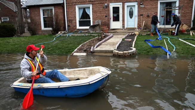
In places like Clarksville and the Illinois town of Grafton just across the river, it's always been the clear views of the Mississippi drawing the tourists, unobstructed by a permanent levee. But that's left both communities north of St. Louis vulnerable.
By Monday, the rain-swollen river strained a hastily erected makeshift floodwall in Clarksville, creating two trouble spots that volunteers were scrambling to patch – as well as build a second sandbag wall to catch any water weaseling through.
But though the Mighty Mississippi is starting to recede, another batch of rain threatens to push it back up. A swath from Oklahoma through Michigan is forecast to get an inch of rain – in some cases slightly more – through Tuesday. The National Weather Service said some river levels again could rise, blunting their slow retreat.
Mark Fuchs, a National Weather Service hydrologist, said the latest dousing could be especially troubling for communities along the Illinois River, which he said is headed for record crests.
"Along the Illinois, any increase is going to be cause for alarm, adding to their uncertainty and, in some cases, misery," he said late Monday afternoon.
Last week's downpours brought on sudden flooding throughout the Midwest, and high water is blamed for at least three deaths. Authorities in LaSalle, Ill., spent Monday searching for a woman whose van was spotted days earlier near a bridge over the flooded Illinois, and a 12-year-old boy was in critical condition after being pulled from the Big River near Leadwood, Mo., about 65 miles south of St. Louis, after floodwaters swept him away as he tried to walk across a bridge.
Flooding along the Mississippi doesn't have the impact today that it had during the Great Flood of 1993. Since then, thousands of homes have been bought out, so the flood plain in many places is largely green space. Other places have built better flood walls and levees.


Weather Service To Suffer Budget Cuts, Furloughs During Hurricane Season 2013


The nation's cash-strapped weather-forecasting system, though partly spared from federal budget cuts known as sequestration, is about to get pinched on the verge of a hurricane season expected to be busier than normal.
Federal officials say they have the resources to warn storm-prone areas about weather emergencies, but a federal union representative warns that a hiring freeze plus furloughs threaten public safety.
Aircraft known as Hurricane Hunters will keep flying into storms to measure wind speed and air pressure, though their flight crews will have to take turns being furloughed. Weather satellites will remain on track, though the offices that monitor them will get squeezed.
Officials say they can maintain adequate staffing at the National Hurricane Center near Miami, though its forecasters will be forced to take off four unpaid days by Sept. 30. Staff at the National Weather Service already is depleted because of a hiring freeze.
"This could have a detrimental effect on everybody's public safety," said Bob Ebaugh, the steward in Miami for the National Weather Service Employees Organization. "Once you start limiting staffing, you start raising the potential for disaster."
He said furloughs could hamper the NWS' ability to predict wildfire and tornado conditions during the spring and to pinpoint where storms might hit land during the summer. Citing 250 vacancies throughout the Weather Service, Ebaugh said the agency "saves money from not filling those positions, which just caused more stress on the rest of the employees."
This mix of warnings and assurances comes on the heels of an extraordinary year of storms, flooding, blizzards and droughts -- 11 separate billion-dollar disasters in 2012, capped by Superstorm Sandy. Weather-conscious Florida, where a tourism economy depends on the great outdoors, has the most at stake from any gaps in forecasting.

http://www.huffingtonpost.com/2013/04/23/hurricane-season-budget-cuts_n_3142713.html?utm_hp_ref=weather

Snow On July 4th Due To Odd Weather In Western States


A summer that looks a whole lot more like winter has travelers across the West scrambling to revise their Fourth of July itineraries – or at least their packing lists.
Ski poles are replacing fishing poles at popular hiking and camping spots where late-winter snowstorms blanketed Western mountains from the Rockies to the Sierra Nevada.
"A lot of people are calling it the trifecta day, where they're going to ski in the morning, mountain bike in the afternoon, maybe do something on the lake in the evening," said Julie Mauer, a spokeswoman at Sierra ski resort Squaw Valley, which saw record-breaking snowfall this season. The resort plans to open four ski lifts on the upper mountain and promises free commemorative July 4 t-shirts to the first 5,000 guests who show up on Monday.
At Crystal Mountain, south of Seattle, spokeswoman Justus Harris said she expected to see "a lot of bikini tops" out on the slopes. The National Weather Service is predicting mostly sunny skies on the mountain on July 4, with a high near 59 degrees. The mountain hasn't been open this late in the year since 1999.
An unseasonably strong low-pressure system has brought above-average rainfall to California's Central Valley and the Sierra earlier this week, and the National Weather Service on Thursday issued a flood warning for much of the region, cautioning that warming temperatures leading into the weekend will accelerate snowmelt and cause rising water levels in rivers and streams.
At lower elevations, the spring thaw has led to surging waterways, turning normally easy crossings perilous and raising flood concerns.

http://www.huffingtonpost.com/2011/06/30/snow-july-4th-independence-day_n_888217.html

Mary Yoder, Pregnant Amish Woman, Killed By Lightning On Due Date


Lightning Strikes Amish Woman
Mary H. Yoder, a pregnant Amish woman picking berries in the woods near her Garrett, bad news, Pennsylvania, home, was killed by lightning on her due date. The fetus also died.
©2013 MapQuest  -  Portions ©2013 Natural Earth | Terms
GARRETT, Pa. -- A pregnant Amish woman picking berries in the woods near her Pennsylvania home was killed by lightning on her due date. The fetus also died.
State police say 36-year-old Mary H. Yoder was with her husband and two children late Tuesday morning when a storm moved in. Yoder took shelter under a pine tree while her husband and the children ducked under a different tree.
Police say lightning struck a few minutes later, killing Yoder and her fetus. Trooper Steven Limani tells the Pittsburgh Tribune-Review that Tuesday was the due date.
Police are investigating.
Garrett is about 75 miles southeast of Pittsburgh.


http://www.huffingtonpost.com/2012/07/25/mary-yoder-pregnant-amish_n_1700500.html

Lightning Strikes Girl On Sunny Day

http://www.huffingtonpost.com/2011/07/27/lightning-strikes-sunny-day_n_910925.html


CANONSBURG, Pa. -- An 11-year-old western Pennsylvania girl is recovering after she was struck by a bolt from the blue.
Lisa Wehrle tells the Observer-Reporter newspaper of Washington, Pa., that the sun was shining when her daughter, Britney, was struck by lightning Friday, apparently from a storm several miles away.
Lisa Wehrle says, "There was no rain. It was a beautiful day. All she heard was some thunder."
The lightning hit Britney as she was walking down a hill in North Strabane Township with a friend about 2:30 p.m. that day. The bolt hit her on the left shoulder, leaving a burn-like mark and exited her wrist, where it left another mark.
She was treated at a Pittsburgh hospital. Doctors discovered her arm was broken, but otherwise she's OK.

Chicago's Wettest April


As if we really needed official confirmation, this is now the wettest April on record in Chicago, according to the National Weather Service.

The .70 inches of rain that fell at O’Hare International Airport on Tuesday brought the monthly total to 8.54 inches, a new monthly rainfall record, the weather service said.

The Top 5 wettest Aprils on record in Chicago are:

2013 -- 8.54 inches
1947 -- 8.33 inches
1975 -- 7.84 inches
1909 -- 7.73 inches
1983 -- 7.69 inches


As of Wednesday morning, flood warnings remained in effect for several rivers throughout Illinois and northwest Indiana.

Gov. Pat Quinn has issued disaster proclamations in 44 Illinois counties in the wake of last week's torrential rains and flooding.

http://www.nbcchicago.com/weather/stories/chicago-april-2013-wettest-ever-204607461.html


Source: http://www.nbcchicago.com/weather/stories/chicago-april-2013-wettest-ever-204607461.html#ixzz2RSBMVTgv

Ice Boulders Invading Lake Michigan


The shores of Good Harbor Bay on Lake Michigan are being invaded by a strange phenomenon: Giant ice boulders.
Hundreds of basketball-sized ice bouldersweighing up to 75 pounds have been piling up on the lake for the last week or so.
It's not uncommon, but it's definitely unusual, according to Tom Ulrich, Deputy Superintendent from the Sleeping Bear Dunes National Lakeshore.
"It's not that it never happens and this is a once in a decade thing," he told UpNorthLive.com. "It happens more often than that, but these are very large and got bigger than they normally get."
The giant frozen balls are created when ice chunks form along the shore, get churned back and forth by the waves and grow slowly in the just-below-freezing water, a process that also helps to smooth the boulders, according to Lisa Myers, Sleeping Bear National Lakeshore's chief of interpretation and visitor services.
"The Great Lakes create their own weather," Myers told the Los Angeles Times,adding that the boulders compete with ice caves and large icicles for the park's most interesting ice creations.
Ledia Olmstead is credited with making the frozen balls a hot item on the Internet. She saw them while walking with her dog and her heart melted.
"I have a small English bulldog and they were as tall as her. They were pretty massive," she said, according to UPI.com.

http://www.huffingtonpost.com/2013/03/01/ice-boulders_n_2791841.html

Cleanup begins for Albany Park residents after Chicago River overflows


The U.S. geological survey says the level of the Chicago River was nine inches higher than during the last big flood there in 2008.
The Chicago River crested at 8.57 feet on Thursday, and fell below flood stage on Friday. The river will continue to recede, and is expected to hit 6-feet on Saturday.


2013 Smart Guide: Arctic melt will spark weird weather


Melting, rather than warming, is likely to be the big climate issue of 2013.
Predictions that a major El NiƱo warming event - and the coming solar maximum - would help make next year the warmest on record now seem wide of the mark. All eyes will probably be on the Arctic instead. Some say therecord loss of sea ice in summer 2012 was a one-off, others that it was the start of a runaway collapse. If the latter, summer sea ice could virtually disappear as early as 2016. What is certain is that the ice reforming now will be the thinnest on record, priming it for destruction next summer.
A new record melt would allow scary satellite images of an even bluer Arctic to coincide with the Intergovernmental Panel on Climate Change's next assessment, due in September (though a draft has been leaked - see "What leaked IPCC report really says on climate change"). Such pictures will be a sombre backdrop as the IPCC raises its previously cautious estimates of future polar melting and the speed of sea-level rise.
With warming of at least 2 °C now unstoppable, politicians at the recent Doha climate talks spent much time discussing how to adapt. What they need is predictions for individual countries. But the IPCC will admit that it still cannot say whether many regions will get wetter or drier. And it will quietly bury its confident predictions, made in 2007, of more frequent droughts, which turned out to rest largely on flawed analyses.
There is growing uncertainty, too, about the outlook for the northern hemisphere. Research in 2012 implicated the fast-warming Arctic in a slowing of the jet stream. This is bringing extreme weather to mid-latitudes, including prolonged cold spells in Europe, Russia's 2010 heatwave, and record droughts in the US in 2011 and 2012. Watch out for more weird weather in 2013.


http://www.newscientist.com/article/mg21628965.300-2013-smart-guide-arctic-melt-will-spark-weird-weather.html