Showing posts with label George Pop. Show all posts

Thursday, June 29, 2017

Extreme weather events linked to climate change impact on the jet stream

UNIVERSITY PARK, Pa. — Unprecedented summer warmth and flooding, forest fires, drought and torrential rain — extreme weather events are occurring more and more often, but now an international team of climate scientists has found a connection between many extreme weather events and the impact climate change is having on the jet stream.
The unusual weather events that piqued the researchers' interest are things such as the 2003 European heat wave, the 2010 Pakistan flood and Russian heatwave, the 2011 Texas and Oklahoma heat wave and drought and the 2015 California wildfires.
This constrained configuration of the jet stream is like a rollercoaster with high peaks and valleys, but only forms when there are six, seven or eight pairs of peaks and valleys surrounding the globe. The jet stream can then behave as if there is a waveguide — uncrossable barriers in the north and south — and a wave with large peaks and valleys can occur.
http://news.psu.edu/story/458049/2017/03/27/research/extreme-weather-events-linked-climate-change-impact-jet-stream


NORTH POLE SEA ICE DISAPPEARING VERY RAPIDLY 4.7.2016

Arctic sea ice volume has been in decline for decades. While this may look like a steady decline, chances are that the sea ice will abruptly collapse over the next two months.
Sea ice decline reflects the extra energy added to the Arctic, as global warming and feedbacks are hitting the Arctic particularly strongly. Three of these feedbacks are depicted in the image on the right.
As the sea ice melts, sea surface temperatures will remain at around zero degree Celsius (32°F) for as long as there is ice in the water, since the extra energy will first go into melting the ice. Only after the ice has melted will the extra energy start raising the temperature of the water.
Once the sea ice has disappeared, a lot more energy will get absorbed by the Arctic Ocean, i.e. energy that was previously reflected back into space and energy that previously went into changing ice into water.

Furthermore, as the sea ice disappears, chances increase that storms will develop that come with rain and winds that can batter and push the remaining sea ice out of the Arctic Ocean, while storms can also increase the amount of water vapor in the atmosphere and the occurrence of cirrus clouds that can trap heat.
http://arctic-news.blogspot.com/2016/07/extreme-weather-events.html


Monday, June 26, 2017

Fishy Rain to Fire Whirlwinds: The World's Weirdest Weather

https://www.livescience.com/11344-world-weirdest-weather.html
When Mother Nature Throws a Curve Ball
As if tornadoes, hurricanes and blizzards weren't enough to keep us on our toes, Mother Nature occasionally surprises us with some truly odd weather phenomena: From whirlwinds of fire to bloody rains, it's a strange world of weather out there.
Raining Fish and Frogs From
California to England to India, people have periodically reported a fishy form of precipitation: small animals, such as fish, frogs, and snakes have occasionally fallen unexpectedly from the sky, sometimes miles away from water.

Great Balls of Fire
Balls of light, ranging from the size of a golfball to a football, occasionally float through the air during storms, undoubtedly surprising anyone they happen to encounter.
The Sky is Bleeding!
Showers of blood falling from the sky have been reported since ancient Roman times. Though they often horrified the people they fell upon, these rains were not actually blood. They were caused by dust or sand blown into the atmosphere and carried long distances by strong winds, eventually mixing with rain clouds and coloring the rain.

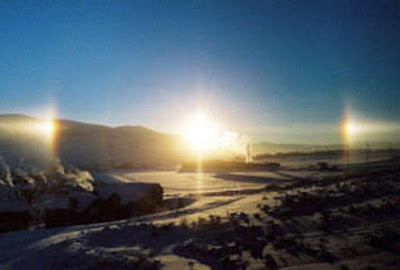
Seeing Triple                                                                                                                                         Even on a clear, sunny day, the sky can hold some surprises, at least for the eyes. If the Sun is close   to the horizon and feathery cirrus clouds sit high in the sky, 'ghost' images of the Sun will sometimes materialize on either side of it, giving the appearance of three Suns shining in the sky.


How Climate Change Will Transform the Way We Live

Earlier this week, nearly 50 flights out of Phoenix were cancelled. At 120 degrees, the temperature forecast exceeded the airline’s 118 degrees maximum operating temperature.
It’s difficult not to connect the delays to climate change—scientists estimate the planet’s overall temperature has increased by 1.8 degrees since preindustrial times. Last year was the hottest on record, followed by 2015, followed by 2014.
Here’s how he predicts global warming will impact day-to-day life in the U.S. within the next century:   For much of the U.S., summer will take place indoors.
                Power outages will result in deaths.
                Roads and train tracks will melt and buckle under the heat.
                                                                     High-rise buildings at sunrise. junyyeung Getty Images

Unusual weather in Antarctica leads to rain and a Texas-sized melt

An area larger than the state of Texas in West Antarctica melted to an unusual degree last year, with pools of the meltwater remaining on the surface for as long as 15 days. That’s trouble, since meltwater can accelerate the thawing already occurring from warming ocean temperatures. West Antarctica alone could contribute 10 feet of sea level rise.
https://www.theverge.com/2017/6/15/15811214/west-antarctica-ross-ice-shelf-melting-rain-el-nino


Climate change will expose half the world to killer heat waves, scientists say

Climate change will sharply boost the frequency of lethal heat waves even if humanity caps global warming at two degrees Celsius (3.6 degrees Fahrenheit), the core goal of the Paris Agreement, scientists said Monday.
Fulfilling that 196-nation pledge would, by 2100, still leave nearly half the world's population exposed at least once a year to bouts of heat and humidity that have proven deadly in the past, they reported in the journal Nature Climate Change
Under a "business-as-usual" scenario, in which greenhouse gases continue pouring into the atmosphere at current rates, three-quarters of humanity will annually face what the researchers call "lethal heat events."
A man uses a branch with leaves to try to put out flames from a forest fire near Gois, Portugal, June 19, 2017. A sweltering heat wave is blamed for deadly fires in the country.

Sunday, June 25, 2017

Strange Atlantic Tropics in 2017: Early Start and an Unusual Location for Formation

Tropical activity in the Atlantic Basin is off to a quick start with three named storms already this year. But that's just one of several strange events we've already seen during this Atlantic hurricane season.
Here are four weird things we've seen so far this year, one of which happened before the Atlantic hurricane season officially began:
1. Strange Tropical Season Begins in April
2. Bret Forms in an Unusual Location
3. Two Simultaneous Named Atlantic Storms in June
4. Multiple Storms Early in the Season

https://www.wunderground.com/news/strange-atlantic-tropics-2017-hurricane-season

                                 Arlene's path history in the central Atlantic during April 2017.


Each red dot shows the origin point of a storm in the Atlantic during June since 1950. Notice that Bret is far removed from the typical northwest Caribbean and Gulf of Mexico breeding ground.

Floating Fire Ant Balls: Cindy's Lesser-Known Danger

Flooding remains the primary concern after Tropical Storm Cindy made landfall, but officials in Alabama are warning of another, less obvious danger from the storm – massive balls of floating fire ants.
These biting, stinging insects live in colonies of up to 500,000 ants, and during floods the entire colony can, according to the Imported Fire Ant Research and Management Project (IFARMP) at Texas A&M University, “form a loose ball, float, and flow with the water until they reach a dry area or object they can crawl up on.”
Fire ants, which were accidentally imported from South America in the early 1900s, are now native across the Southeast. Tropical Storm Cindy soaked much of their habitat, dumping over a foot of rain in places in Mississippi and 6 to 8 inches in parts of Alabama, Florida, Georgia and Louisiana.
https://www.wunderground.com/news/floating-fire-ant-swarms-hidden-danger-of-tropical-storm-cindy

Deadly Heat Waves Could Threaten 3 in 4 People By 2100

Even with aggressive reductions in carbon emissions, extreme heat is going to get worse, a new study has found.
WASHINGTON — If humans fail to drastically cut carbon emissions, 3 in 4 people on the planet could be exposed to deadly heat waves by the end of the century, a new study has found. 

And even if countries take action to reverse climate change with aggressive emissions reductions, up to 48 percent of the global population will be plagued by at least 20 days of lethal heat per year by 2100. 
And the problem isn’t just for the future. The threat is already here, with roughly 30 percent of the human population exposed to deadly conditions each year.

Inmates Left to Rot in 120-Degree Heat

An ongoing heatwave in Phoenix, Arizona is so extreme that flights out of the region have been cancelled. But inmates at Tent City, a notorious outdoor jail, are expected to endure conditions too dangerous for jet planes.
The Tent City began as an overflow site for Maricopa County, Arizona’s already-packed jails. The fenced-in facility has housed up to 1,700 inmates outdoors in canvas tents, where temperatures ranged well above and below safe limits, earning the condemnation of human rights organizations.
But while heat wave temperatures soar to 120 degrees Fahrenheit and Phoenix officials warn locals to remain inside, hundreds of Tent City inmates remain confined outdoors.
In April, the sheriff’s office announced a six-month process of closing the facility.
http://www.thedailybeast.com/inmates-left-to-rot-in-120-degree-heat

With 3 Named Storms Already, What Should We Expect for the Remainder 2017 North Atlantic Hurricane Season?

A number of forecast centers have already made their predictions for the 2017 hurricane season with most sources predicting either a normal to somewhat above normal season. There is, however, quite a range in the total number of expected named storms, ranging from as low as 10 to as much as 17. The most likely number being 12-13 storms. For hurricanes, the range is from 6-10 with the most likely number being about 6 hurricanes. For major hurricanes, estimates range between 1 and 4, the most likely number being 2 or 3.
One factor most forecasters are looking at is that there will be either a weak El Nino or as neutral ENSO conditions will prevail during the peak of this year’s season as well as warmer than normal SST across the tropical Atlantic and Caribbean Sea. If we have a weak El Niño, then the likelihood is for a normal to somewhat below normal season. If, however, as predicted by NOAA, the current neutral ENSO conditions prevail, then a somewhat more active season is possible.

http://gcaptain.com/3-named-storms-already-expect-remainder-2017-north-atlantic-hurricane-season/

Paris rolls out anti-pollution measures amid European heat wave

Authorities in Paris this week rolled out a series of measures to limit pollution, which has reached worrying levels amid a heat wave gripping France and other European countries.
Paris officials on Thursday imposed driving restrictions in and around the capital, urging residents to leave their cars parked as a way of curbing the current air pollution peak.
An alternative-day driving ban started on Thursday, with the most-polluting vehicles barred entirely from driving in the city. Police also reduced speed limits in some areas and diverted heavy goods trucks.
Paris Mayor Anne Hidalgo announced that the city’s Velib’ bike-sharing programme, as well as residential parking, was free on Wednesday and Thursday.
http://www.france24.com/en/20170622-paris-pollution-peak-driving-ban-europe-heat-wave-longon-portugal

Weekend heat wave set to sweep south coast from Whistler to Hope

A heat wave is set to sweep the Lower Mainland this weekend before cooling down on Monday. Special weather statements have been issued for the region stretching from Whistler all the way to Hope.
“A strong upper ridge of high pressure building over the province will result in a brief heat wave over southwest B.C.,” read a weather statement from Environment Canada.
Temperatures will reach 32 degrees Celsius near the water, with temperatures expected to hit the high 30s over the southwestern B.C. Interior.
The weather forecaster also suggests some record highs could be broken; Abbotsford’s record high for Saturday is 31.4 degrees, while Sunday’s is 32 degrees.


http://vancouversun.com/news/local-news/weekend-heat-wave-set-to-sweep-south-coast-from-whistler-to-hope


Burns from hot pavement, cars are up due to heat wave

The heat wave scorching the Southwest U.S. can be to blame for an uptick in admissions at a major burn center in Phoenix, Arizona. Doctors are cautioning those living in Phoenix, and other areas where temperatures are high, how to avoid burns and other heat-related dangers.
The Arizona Burn Center has seen its emergency department visits double during the current heat wave, including cases where people have burned their bare feet on the scalding pavement.
The heat wave brought a high of 119 degrees (48 degrees Celsius) in Phoenix on Tuesday. Las Vegas topped out at 117, and California has been broiling in triple-digit temps.
http://www.cbsnews.com/news/burns-from-hot-pavement-cars-heat-wave-phoenix-arizona/


The Southwest U.S. heat wave broke dozens of temperature records

An unusually wide-reaching and long-lasting heat wave has gripped at least six states for an entire week, breaking or tying dozens of hot weather records. Temperatures were so high that certain aircraft couldn't fly out of airports including Phoenix and Palm Springs, offering a preview of what may happen to transportation networks as the climate continues to warm due to human-caused climate change.
 http://mashable.com/2017/06/23/heat-wave-southwest-5-most-impressive-records/#9rYH8Ft1qOqT


Monday, June 19, 2017

Atlantic faces the rare prospect of two active tropical storms in June

Although the Atlantic hurricane season begins June 1, the bulk of the tropical activity typically clusters during the middle months of August, September, and October when the seas reach their peak temperatures. This year has already been unusual, however, with the formation of a highly rare tropical storm in April—Arlene, which meandered around the open Atlantic Ocean for a few days.
From a climatic standpoint, the development of two more tropical storms in June this year would be intriguing. During a normal year, the Atlantic basin—which includes the Atlantic Ocean, Caribbean Sea and Gulf of Mexico—typically doesn't produce its third named storm until mid-August.
https://arstechnica.com/science/2017/06/atlantic-faces-the-rare-prospect-of-two-active-
tropical-storms-in-june/

Sunday, June 11, 2017

California ski season to last entire summer, mountains still packed with loads of snow


What is becoming one the West's wettest years on record has stretched winter season for most California and Nevada ski resorts well into spring and, with 2.4 m (8 feet) of snow still on most of the mountains, some resorts now say they will stay open during the entire summer and into the next winter season. For skiers and snowboarders, this is a dream come true as this summer, they'll be able to both ski and surf.
As reported in April, California has spectacularly emerged from one of its driest periods on record and ended its five-year drought by enduring one of its wettest periods on record. Its reservoirs, lakes, and mountainsides are now brimming with water and snow.
The mountains saw an incredible amount of snow, with a number of stations recording over 16.2 meters (638 inches). As of Thursday, April 13, 2017, the Northern Sierra 8-Station Index has surpassed the mark for the wettest water year (October 1 - September 30) on record with 2.28 m (89.7 inches), the office said. The previous water year record was 2.23 m (88.5 inches) set in 1992 - 1983.


'Mother of all storms' fuels Western Cape's largest and most destructive fire in recent memory

The worst winter storm to hit South Africa's drought-stricken province of Western Cape fueled a massive wildfire near the city of Knysna (population 77 000). The fire has so far destroyed at least 150 structures, caused deaths of 3 people and forced 10 000 Knysna residents to evacuate. Provincial fire officials are describing the fire as the largest and most destructive in a built-up area in recent memory. The region is suffering its worst drought in more than 100 years.
Strong winds produced by a massive winter storm, 'mother of all storms' as it's been named by South African media, turned wildfire that started near Knysna on June 6 into a massive blaze on June 7, 2017.


Gigantic jets over Pilbara, Australia on March 28, 2017

Photographer Jeff Miles from Australia has captured several amazing images of very elusive gigantic jets, otherwise known as ionospheric lightning.
Miles witnessed 6 jets on the night of March 28 near a small town in the Pilbara part of Western Australia and you can see some of them below. 
Gigantic jets, along with sprites, elves, blue jets and blue starters, are classified as transient luminous events (TLE). They are a type of upper-atmospheric lightning or ionospheric lightning.
Upper-atmospheric lightning is believed to be electrically induced form of luminous plasma. The preferred usage is transient luminous event, because the various types of electrical-discharge phenomena in the upper atmosphere lack several characteristics of the more familiar tropospheric lightning.


Sea level rise will double coastal flood risk worldwide

Small but inevitable rises in sea level will double the frequency of severe coastal flooding in most of the world with dire consequences for major cities that sit on coastlines, according to scientists.
The research takes in to account the large waves and storm surges that can tip gradually rising sea levels over the edge of coastal defences. Lower latitudes will be first affected, in a great swath through the tropics from Africa to South America and throughout south-east Asia, with Europe’s Atlantic coast and the west coast of the US not far behind.
The most vulnerable places, including large cities in Brazil and Ivory Coast, and small Pacific islands, are expected to experience the doubling within a decade.

High tides lash Mumbai on the western Indian coast. A sea level rise of 5-10cm could double the flood risk. Photograph: Pal Pillai/AFP/Getty