Showing posts with label Joanna Rozek. Show all posts

Wednesday, November 11, 2015

5 things you need to know about the big storm heading toward Michigan

http://www.mlive.com/weather/index.ssf/2015/11/top_five_things_to_know_about.html

A large storm is heading toward Michigan and the Great Lakes. There are five things you should know about this storm.
The storm will dominate Michigan's weather from Thursday, Nov. 12 through Friday night.
The graphics above walk you through the most important elements of this storm.
This is not a historic storm. It's powerful and will cause a few dead trees to fall and driving to be difficult, but it won't be a storm remembered for years. The exception to that is if widespread severe thunderstorms develop. That's possible but not likely.
The wind will be the main thrust of this storm, and it will be strongest in the southern half of Lower Michigan. The first two graphics show the wind gusts at 2 a.m. and 7 p.m. Thursday. The strong 50 mph plus wind gusts will hit the Lake Michigan shore by Thursday morning. Then the strong wind gusts will move across southern Lower and be in Ann Arbor, Detroit, Jackson, Flint and maybe Saginaw/Bay City by afternoon.
Winds will be gusting up to 40 mph everywhere Friday morning, and then gradually diminish late Friday.
Top wind gusts are expected to be isolated and around 55 mph. That brings a few dead trees down, and can cause isolated power outages.
Severe storms are possible
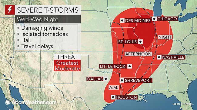
Just southwest of Michigan a severe weather outbreak is likely. Illinois and Iowa could have tornadoes, damaging winds and large hail. For Michigan, we are in a five percent chance of damaging winds from thunderstorms.
If thunderstorms started generating high winds, isolated locations could have over the anticipated 55 mph limit. Again, it's possible, but only a five percent chance.
Rain will be heaviest north
The heaviest rain will be over one inch and fall in the northern half of Lower and most of the U.P.
In southern Lower, the line of rain will blow through so quickly, we can look for only a few tenths of an inch of rain.
Temperatures tumble Friday
Based on what we are used to this year, Friday will be a shock to the system as colder air moves in. It's not really cold air for Michigan in November, but it's "cold" by this current November's standards.
Thursday afternoon temperatures will drop into the 40s in southern Lower. Friday temperatures will be stuck in the upper 30s and low 40 for southern Lower. It's a far cry from last year's record November cold.
By Sunday we will start another slow warming trend.
First flakes for many
Friday will be cold enough aloft that snow flakes will mix with rain showers. The western U.P. could change to all snow and have one to three inches total.
For Lower Michigan it will just be something to see in the air. A dusting to one half inch is possible in the northern and western part of Lower Michigan. The rest of Lower Michigan may just see white stuff in the air at times. The ground and roads will be way too warm for any snow to stick.
Author's note
So get ready for a potent storm, but certainly one we've lived through before. In fact, I would compare this storm in strength to last week's storm. The difference of course is we had three isolated, brief tornadoes with the storm last week. I wouldn't anticipate that again, but let's keep our eyes open.



Snow belts Colorado, high winds threaten Midwest

http://www.usatoday.com/story/news/nation/2015/11/11/winter-storm-blasts-colorado-threatens-midwest/75568302/

A snowstorm roared into Colorado, Nebraska and Kansas on Wednesday as a large swath of the Midwest and Plains braced for howling winds Thursday.
The threat for severe storms, including tornadoes, remained high late Wednesday in portions of Nebraska and Iowa. A possible tornado damaged buildings in Corning, Iowa, in the afternoon, the National Weather Service reported. There were no reports of injuries.
The main threat Thursday will be strong winds across a wide portion of the north-central U.S. Gusts up to 60 mph are expected in some areas from the central Rockies to the Great Lakes.
Strong winds could lead to power outages, tree damage and travel disruptions Thursday in Chicago, Detroit and Pittsburgh, AccuWeather said.
While wind speeds may die down a bit Thursday night, gusts over 50 mph may persist particularly over and downwind of the southern Great Lakes, according to the Weather Channel. The high winds will spread into the Northeast and Mid-Atlantic on Friday.
On Wednesday, 6 to 12 inches of snow fell on the Front Range in Colorado and the mountains in Wyoming, with several inches of snow around the Denver metro area, according to AccuWeather.
Earlier in the week, snow blanketed portions of the western U.S., with up to 10 inches in parts of the Reno area, the Weather Channel reported.
Blame the recent tumult on the jet stream. A powerful southern dip punched into the Plains and Midwest, clashing with warmer, moist air sliding north, the Weather Channel reported.

Extreme El Niño: Drought-Stricken California in the Crosshairs of Wild Weather

http://www.nbcnews.com/news/weather/extreme-el-nino-drought-stricken-california-crosshairs-wild-weather-n460796

After four years of a historic drought that has ravaged virtually every corner of California, this winter could usher in a new challenge: A series of storms with rains so heavy and so punishing that mudslides and flooding would be the norm, forecasters warn.
That's because of an El Niño weather phenomenon that will target California — perhaps in ways that haven't been documented for decades, said Bill Patzert, a climatologist with NASA's Jet Propulsion Laboratory.
"This is larger, it's more intense, and it's still growing," Patzert told NBC News' Al Roker.
The El Niño weather pattern creates an occasional warming of the Pacific Ocean around the equator, and when it occurs, it typically brings more winter rain to California and much of the South and East.
El Niño is causing temperatures in the normally cold Pacific to rise about three degrees higher, and the subtropical jet stream, which typically moves south of California, to shift farther north.
"Riding that jet stream will be a series of storms like a conveyor belt — almost like a convoy," Patzert said.
But how dire the above-average rainfall would be remains to be seen. Los Angeles County's "El Niño 2015-2016" report puts it this way: "Most weather experts acknowledge the weather phenomenon is as temperamental as a toddler."
Still, even before winter, Southern California has already gotten socked by grueling storms this season. Deadly flooding trapped hundreds of motorists and triggered massive mudslides last month just north of Los Angeles, forcing the heavily traveled Interstate 5 to close for several hours.
"It's going to be a mess ... when these great rains come. There's nothing to hold the water and we are expecting debris, mud, water to come pouring out of the mountains," Patzert warned.
Normally, vegetation helps soil to cling to hillsides, but after a fire burns it off, the dry land is barren and susceptible to major mud flows because of heavy El Niño rains, Roker added.
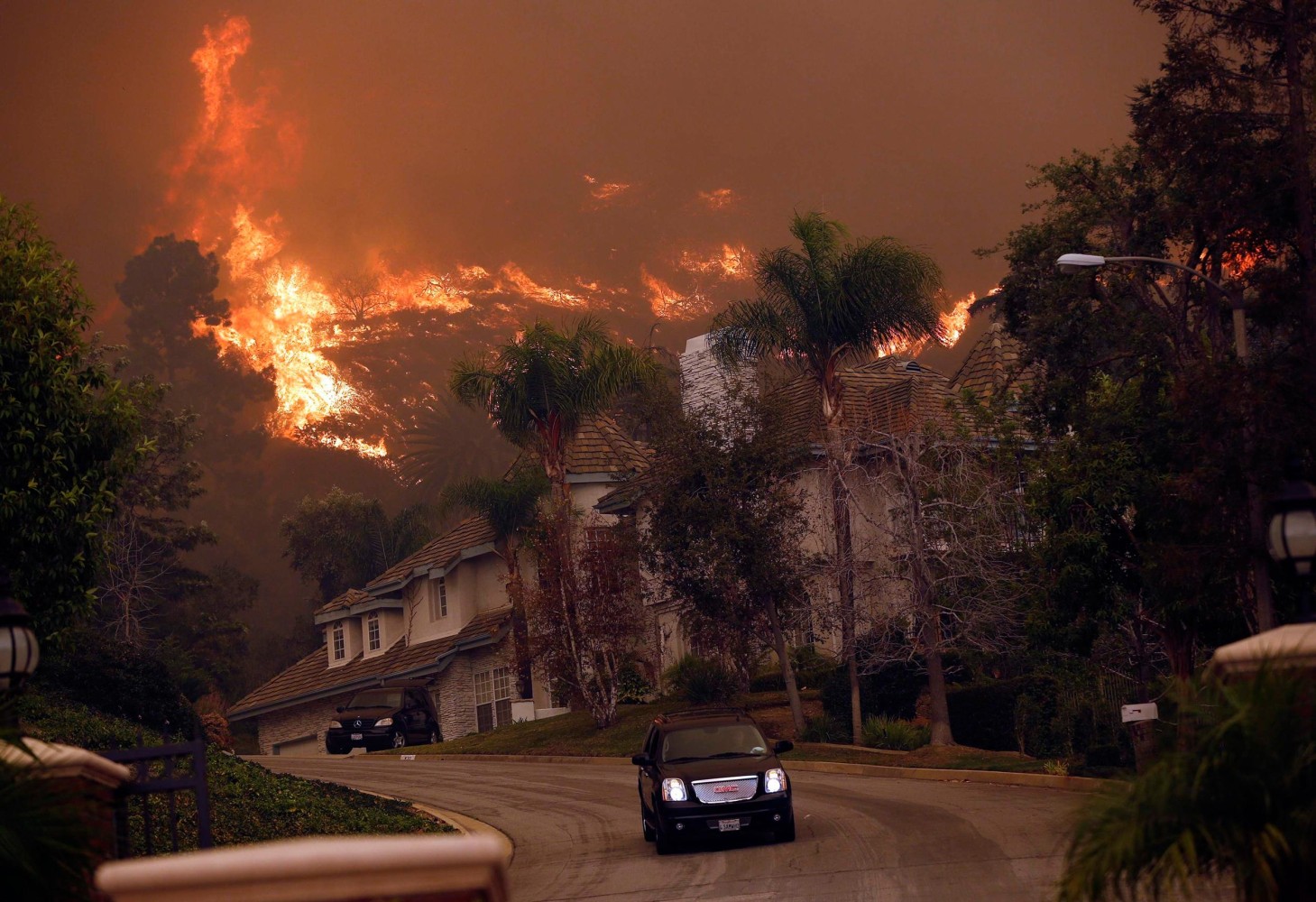
When the Colby Fire struck the hillsides above the Los Angeles suburb of Glendora in January 2014, it burned over 2,000 acres and left parched patches that exist today.
Image: A car drives away from the Colby Fire in hills above Glendora, Calif.
A car drives away from the Colby Fire in hills above Glendora, Calif., on Jan. 16, 2014. MARIO ANZUONI / Reuters
Glendora resident Sandra Blaydow said her home survived the wildfire, but it was in the crosshairs again last year when a monster mudslide sent four feet of the sludge flowing down the hillside.
She's heeding the warnings to be ready this time around.
"I'm very worried," Blaydow told Roker. "As a matter of fact, as of this morning, I was still making sure that everything got reinforced."
Federal and local emergency officials have been alerting California residents about what to expect this winter. They advise people to have their homes reinforced and escape plans in place.
Capt. Keith Mora, of the Los Angeles Fire Department, added that residents who decide not to flee the flames put emergency workers at risk.
"If you're staying back when we're asking you to evacuate or get out, it's very dangerous," he said. "And hosing down your roof is not gonna protect your life and property. You need to heed the evacuation orders."
Los Angeles County launched an El Niño preparedness website to give residents up-to-date information while making sure they have a checklist in place if the weather turns volatile.
"The forecast(s) if they come true, there is potential for some very intense rains and some extreme weather events," said Gail Farber, the director of the Los Angeles County Department of Public Works. "And it's not just rain. It can be the wind that can bring down power lines and folks go without power."
"It's highly likely that we can see more of those extreme events," she added, "and that's what is so imperative — (that) our communities plan now."

Extraordinary "Cloud Tsunami" Surges in Over Sydney

http://www.mymodernmet.com/profiles/blogs/syndey-cloud-tsunami-2015

A bizarre meteorological event hit the coast of New South Wales, Australia over the weekend. Dubbed a "cloud tsunami" on Twitter, this massive wave in the sky measured several kilometers long and swept over the city of Sydney, bringing with it powerful thunderstorms, heavy rains, and forceful winds that required the Australian Bureau of Meteorology to issue a warning for the surrounding area.
The massive formation is actually called a shelf cloud, composed of arcus clouds. The shelf cloud is typically the leading edge of a thunderstorm, attached to the base of the parent cloud that contains the storm. The strange wave-like appearance is caused by the cool sinking air from the storm’s downdraft spreading out over the land, meeting the warm air being drawn into the storm’s updraft.
The apocalyptic impression of this "cloud tsunami" caused quite a flurry on social media, along with the weather upset that it brought to Sydney. 

Storm Abigail forecast to batter Scotland with severe gales

http://www.theguardian.com/uk-news/2015/nov/11/storm-abigail-forecast-met-office-scotland-severe-gales

Storm Abigail, the first weather system to be given a name under a new Met Office project, is forecast to lash Scotland with severe gales on Thursday and Friday.
While much of Britain continues to enjoy record mild temperatures for November, thanks to south-westerly winds, an Atlantic depression linked with that same weather pattern, is forecast to cause severe gales of 80mph or more for north-west Britain.
The Met Office has issued a yellow – “be aware” – warning for the north and north-west of Scotland with high gusts in exposed areas risking travel disruption. It also warned that Storm Abigail could cause high waves to come over the top of seafronts.
The Met Office said: “A vigorous depression is expected to pass just to the north-west of Scotland on Thursday night bringing a swathe of very strong winds on its eastern and southern flanks.”
Storm Abigail is the first such weather system affecting the British Isles to bear a name as part of the “name our storms” project, using names chosen by the public.
Eddy Carroll, chief meteorologist at the Met Office, said: “We now have our first named storm. It’s called Abigail … and it is expected to come eastwards quite quickly … bringing some very strong winds on its southern flank. There is inevitably some uncertainty about the track it’s going to take and the ultimate intensity it is going to reach but there is quite a lot of evidence that it could be quite a deep feature bringing winds possibly as much as 80mph or more.”
It is hoped the name our storms project, inspired by storm warnings used in the US and elsewhere in the world, will help raise awareness of severe weather and ensure greater safety of the public.
Under the scheme, storms will be named when they are deemed to have the potential to cause a substantial impact in the UK and/or Ireland.
Abigail is the first on the list of winning names, followed by Barney, Clodagh, Desmond, Eva, Frank, Gertrude, Henry, Imogen, Jake, Katie, Lawrence, Mary, Nigel, Orla, Phil, Rhonda, Steve, Tegan, Vernon and Wendy.
On Tuesday the Met Office recorded the warmest November night on record when warm winds meant the temperature in Murlough, County Down, did not drop below 16C. It comes after 1 November broke records as the warmest November day when the temperature in Trawsgoed, Wales, hit 22.3C.
Met Office scientists predict that 2015 will be the hottest year on record. Data from January to September 2015 shows global average temperatures have risen by 1C for the first time compared with pre-industrial times. The rise is due to the influence of increasing carbon emissions combined with the El Niño climate phenomenon currently under way.
high winds hit Blackpool's north pier

Hurricane Kate becomes fourth hurricane of 2015 Atlantic hurricane season

http://www.aol.com/article/2015/11/11/hurricane-kate-becomes-fourth-hurricane-of-2015-atlantic-hurrica/21263124/

Hurricane Kate became the fourth hurricane of the 2015 Atlantic hurricane season early Wednesday morning while passing well north of Bermuda.
National Hurricane Center specialist Eric Blake said Kate was the latest-in-season tropical cyclone to become a hurricane so far northwest in the Atlantic Ocean on record.
Kate is racing northeast, caught up in the jet stream and will soon become a "post-tropical" cyclone over the north Atlantic Ocean.
Highlights:
  • Hurricane Kate was centered about 260 miles north of Bermuda as of Wednesday morning.
  • The latest forecast calls for Kate to become absorbed by a non-tropical low pressure system Thursday.
  • A few outer bands of rain may affect Bermuda Wednesday, and high surf will likely impact the island as well. Otherwise, little direct impact is expected as Kate passes well to the north.
  • Kate is no threat to the U.S. East Coast.
  • Kate is the eleventh named storm and fourth hurricane of the 2015 Atlantic hurricane season.
  • Kate originally formed as Tropical Depression Twelve Sunday night, and was upgraded to tropical storm status Monday morning.
Due to atmospheric steering currents on the western periphery of high pressure over the open Atlantic, Kate is currently being pulled northeast at over 30 miles per hour.
Shower and thunderstorm activity with locally heavy rain has soaked parts of the East this week from a separate weather system.
Before Kate was named, the incipient tropical wave doused parts of the Lesser Antilles with excessive rainfall. Martinique picked up 192.4 millimeters (7.57 inches) of rain from Thursday through 8 p.m. AST Saturday. Most of that fell Friday, causing serious flooding on parts of the island.
Weather.com

Monday, October 19, 2015

El Niño Creates More Favorable Conditions for Winter Tornadoes in Florida, NWS Says

http://www.weather.com/safety/tornado/news/el-nino-florida-tornadoes

A strong El Niño may raise the chances for an above-average tornado season this winter in Florida, according to meteorologists at the National Weather Service.
The Tallahassee office of the NWS says El Niño is known to push severe weather south in the winter, which leaves central and southern Florida in the bull's-eye. Upon studying El Niño years and otherwise, the NWS found a higher likelihood of tornadoes from November through April than with any other pattern.
"There have been double the number of EF1 or stronger tornadoes associated with past strong El Niños," meteorologist Robert Molleda told the Orlando Sentinel. "In many cases the winds are greater than 100 mph. These are the stronger, more damaging tornadoes."
It's important to note that El Niño doesn't actually create severe weather; the pattern simply helps set the stage for an increase in damaging storms, Molleda said.
The period from November 1997 through April 1998, influenced by one of the strongest El Niño events in recent memory, produced 43 tornadoes in Florida, which the NWS says was the worst year since records began. Of those 43 twisters, seven were at least F3 strength (this was before the Enhanced Fujita Scale was adopted).
In February 1998, a tornado killed 42 people, injured 260 and destroyed hundreds of homes. Before that winter, forecasters issued a similar warning to the one issued this week by the NWS.
These tornadoes frequently occur at night when most are asleep, adding to the pattern's danger, NWS-Tallahassee also said.
It's not guaranteed, however, that this winter will see increased tornadoes. As the Orlando Sentinel notes, during the El Niño years of 1965-66 and 1972-73, there wasn't an increase in the number of tornadoes that hit the Sunshine State.

Winter Outlook 2015-2016: Cold, Wet South and Warm, Dry North, Says NOAA

http://www.weather.com/storms/winter/news/winter-outlook-2015-2016-noaa-wsi

NOAA issued its winter 2015-2016 outlook Thursday, and the strong El Niño's fingerprints are all over it.
"A strong El Niño is in place and should exert a strong influence over our weather this winter," said Mike Halpert, deputy director, NOAA's Climate Prediction Center. "While temperature and precipitation impacts associated with El Niño are favored, El Niño is not the only player. Cold-air outbreaks and snow storms will likely occur at times this winter. However, the frequency, number and intensity of these events cannot be predicted on a seasonal timescale."
Other influences that may play a role this winter are the Arctic Oscillation and the Madden-Julian Oscillation. 
It is important to remember that this forecast is for the winter season as a whole and does not project when and where storms may occur.
Below we take a closer look at the forecasts from NOAA for temperature and precipitation across the U.S. this winter.

Temperatures

For the core winter months of December through February, NOAA says the southern tier of the nation is likely to be colder than average, particularly in Texas and the Gulf Coast states.
Meanwhile, a large swath of the western and northern United States from California into the Pacific Northwest eastward into the Midwest, Great Lakes and Northeast is expected to be warmer than average, overall. 
Above-average temperatures are also likely in Alaska and most of Hawaii.
Keep in mind, these outlooks are overall trends over a three-month period.
An individual cold front or an upper ridge of high pressure can lead to a brief period of colder or warmer weather, respectively, that bucks the overall three-month trend. The same front or area of high pressure can bring a brief period of enhanced precipitation or dry spell that may or may not be indicative of the overall trend that is forecast.  

Precipitation

NOAA also expects winter 2015-2016 to trend wetter than average over much of the southern tier of the nation, from California into the Desert Southwest and into the southern and central Plains, as well as into much of the Deep South and Gulf Coast. The East Coast, from the Southeast into portions of the Mid-Atlantic and into southern New England, may also see a wetter than average winter.
Conversely, a drier-than-average winter is expected over parts of the Pacific Northwest, northern Rockies and into the far northern Plains and parts of the Great Lakes and Midwest.
Much of central and western Alaska, as well as Hawaii, will likely see drier-than-average conditions this winter.
Drought improvement is likely in California this winter, and the Southwest and southern Plains will likely see drought removal.
However, Halpert noted, "California would need close to twice its normal rainfall to get out of the drought and that's unlikely."
On the other hand, drought development is expected in parts of the northern Plains, the northern Great Lakes, as well as in Hawaii. The Pacific Northwest and the northern Rockies will continue to see drought conditions.

El Niño Not the Only Variable

A strong El Niño is expected to persist through the winter, influencing the overall temperature and precipitation impacts. However, other factors indicate that there is a risk for colder temperatures in parts of the East. Two variables, in addition to El Niño, that could play an important role this winter are the Madden-Julian Osciallation and the Arctic Oscillation.
The Arctic Oscillation is a climate pattern characterized by the strength of counterclockwise winds around the Arctic. Its positive phase confines cold air to the polar regions, while its negative phase is associated with cold air penetrating farther south, as well as an increased chance of nor'easters.
The Madden-Julian Oscillation is associated with variations in tropical thunderstorm activity (convection) and is characterized by an eastward-moving pulse of atmospheric features affecting cloud formation, precipitation and pressure patterns. This pulse circles the globe roughly once every one to two months. In turn, the jet streams over the North Pacific and South Pacific can be impacted during the winter due to large-scale changes in tropical convection. This can contribute to blocking activity which impacts the amount of precipitation across the Pacific Northwest.

Three Big Weather Changes This Week: Gulf Moisture Returns, Temperatures Flip-Flop and Southwest Dries Out

http://www.weather.com/forecast/national/news/three-big-changes-next-week-gulf-moisture-southwest-dry-temperature-flip-flop

Three big changes in the weather are expected this week across the U.S., and many will appreciate the difference a week can make. Moisture from the Gulf of Mexico is expected to bring rain to parts of the South, while the Southwest will finally see drier conditions. Temperatures will also flip-flop. The West will experience temperatures closer to average for this time of year and the Northeast and Midwest will feel a warming trend after the recent cold shot.
Tropical Moisture Surges North
This map is intended to show areas where the heaviest rainfall potential exists through next weekend. Locally heavier rain amounts may occur. A pattern shift is expected by midweek with moisture returning to the Gulf Coast. Moist southeasterly winds will also interact with an area of low pressure aloft coming out of the Southwest to produce heavy rainfall in parts of the southern Plains later this week. This includes areas from eastern New Mexico to Texas and Oklahoma.
Wet conditions will persist through the end of the week and into the weekend, and it may be windy at times. Rain may also spread east into Louisiana, Arkansas, as well as parts of lower Mississippi Valley.
The rain will be welcome in many areas, as drought conditions have developed over the summer in much of Texas as well as Louisiana, Arkansas, Oklahoma, Mississippi, Alabama and the Florida Panhandle. Some spots are now in extreme and exceptional drought, even after seeing record rainfall during April, May and June. Wildfires have also developed due to the persistent hot and dry conditions in portions of the Plains. The rainfall late this week could help firefighters and bring down the fire risk.
A few examples of the recent dryness: Houston is almost 5 inches below average in terms of rainfall since Sept. 1, as just over 2.5 inches has fallen. San Antonio has received less than half of their average expected rainfall since Sept. 1. Dallas has only measured a trace of rainfall so far in October. Despite the drought relief, the rain could be locally heavy, resulting in flash flooding.
There is also the chance that a low pressure system, perhaps with tropical characteristics, may develop in the Gulf of Mexico in the week ahead or this weekend.
Even without tropical cyclone development, the threat of heavy rain and thunderstorms is still expected due to the abundant moisture pushing north.
Temperature Flip-Flops
A break from the record heat has arrived for much of the West and southern Plains. In addition, after a shot of cold air this weekend and into Monday in parts of the East, warmer temperatures will return. The coldest air of the season so far made its way across the Midwest and into parts of the East this weekend. Many areas saw their first frost and freeze with lows dropping into the 30s as far south as North Carolina and north Georgia. Lows tumbled into the 20s in parts of northern Minnesota and Michigan on Saturday. Parts of the Ohio Valley and northern New England saw lows in the 20s Sunday morning. Some areas from the northern Great Lakes into the interior Northeast have also seen their first snow of the season this weekend.
The chilly conditions will just be a distant memory by mid-to-late week across the East as highs and lows will rebound quickly to near and even above average. High pressure will slide eastward this week and as it does, a more southerly flow will develop, allowing warmer temperatures to return. High temperatures will climb back into the 70s by Tuesday or Wednesday in the Ohio Valley, Southeast and Mid-Atlantic. Meanwhile, much of the West and southern Plains saw record high temperatures this last week courtesy of a ridge of high pressure. A few cities saw their hottest temperature ever recorded in October including Little Rock, Arkansas, which reached 98 degrees on Oct. 15, and Colorado Springs, which tied its October record of 87 degrees on Oct. 11. An all-time record high temperature for any month of the year was set in Camarillo, California, on Oct. 9 when the mercury climbed to 108 degrees. Las Vegas crushed its record for number of days with a low in the 70s for October, with nine of them through Oct. 15.
The average temperature for Los Angeles month-to-date in October is more than 7 degrees above average and San Diego is more than 8 degrees above average. Two areas of low pressure will move through the West through Wednesday, allowing temperatures to take a dip in most areas, so the record-breaking trend has come to an end. After the storm systems move east temperatures will warm but are expected to remain closer to average for much of the week ahead compared with this past week.
Drier in the Southwest

After flash flooding in portions of the Southwest this past week and this weekend a change is on the horizon. Some of the worst flooding was seen in California, where mudslides stranded motorists. The upper-atmospheric low that has plagued the region for two weeks has finally begun to push eastward. Another low pressure system is now bringing another round of rain to the West through early this week. As the second system pushes east into the Plains, high pressure will bring a break from the rain by midweek to most of the Southwest. Portions of Arizona and New Mexico may not see the dry conditions until the end of the week. By late in the week, sunshine will become more widespread across the Southwest.
Forecast Rainfall Through Next Weekend
This Week's Forecast
Forecast Highs


Climate change could shift New England's fall foliage

https://www.sciencenews.org/blog/science-ticker/climate-change-could-shift-new-englands-fall-foliage

From frost to drought, a lot of factors influence when leaves go from green to the palette of red, orange and yellow synonymous with autumn in New England. Add climate change to the list, researchers report October 19 in the Proceedings of the National Academy of Sciences.  
Using satellite images and weather data, a team at the University of Connecticut measured the impact of frost, heat, wetness, drought, precipitation, elevation and sunlight exposure on the timing of leaf color change and loss. They zeroed in on two forested regions of New England from 2001 to 2012 and crunched those calculations into two climate change scenarios for future decades (2041 to 2050 and 2090 to 2099). 
Moderate temperature increases and drought will delay fall foliage in northern areas, while southern coastal forests will start to lose leaves earlier due to higher heat stress, summer rainfall and autumn frost. 
Beyond complicating tourists' plans, changes in peak foliage dates could have implications for nutrient cycles in those forests, the researchers write. 
Fall foliage at a pond in New England

Monday, October 5, 2015

Possible impacts of ex-Hurricane Joaquin in the UK

http://www.metoffice.gov.uk/news/releases/archive/2015/ex-hurricaneJoaquin

There has been much speculation about what influence Hurricane Joaquin may have on our weather later this week. Hurricane Joaquin, now a Category 1 storm, is currently moving northeastwards away from Bermuda and will continue to weaken as it transitions into a mid-latitude depression and travels across the Atlantic.
Towards next weekend, this low pressure centre will approach the west of the UK but there is some uncertainty as to what impacts, if any, this system will have on the UK as it is still some way off.
A ridge of high pressure will bring fine conditions for many on Thursday and Friday and as high pressure builds from Scandinavia over the weekend this looks like holding back any weather systems approaching from the Atlantic. In fact many places will see fine weather and this means that any impacts from ex-Hurricane Joaquin are likely to be limited to the far west of the UK.
Deputy Chief Meteorologist Laura Paterson said "the forecast is for ex-Hurricane Joaquin to stay away from mainland UK. There is some uncertainty, but the depression is likely to either come to a halt to the southwest of Ireland and weaken, or track to the south of the country and into the Continent.
The south and southwestern parts of the UK may see increased winds with a small chance of gales in exposed areas."
Our meteorologists will continue to monitor the weather and update our forecasts accordingly. If you have plans for the weekend, as ever it's best to check the latest forecast for your area to see what the weather will bring.
Satellite image of Hurricane Joaquin

South Carolina flooding is the type of event climate scientists have warned about for years

http://mashable.com/2015/10/05/south-carolina-floods-global-warming/#OPD3WuocIPql

The epic amount of rain that led to deadly, catastrophic flooding across large parts of South Carolina and North Carolina is an example of exactly the type of supercharged storm system climate scientists have been warning about for years as a likely consequence of global warming.
This storm, like others that have come before it — from a massive deluge that flooded Oklahoma City to a flooding event in Houston, both of which occurred earlier this year — are examples of how the atmosphere is behaving in new ways now that there's more water vapor and heat for weather systems to work with.
It's not that heavy downpours and floods didn't occur before manmade global warming became evident (for the record, they did). The issue now is that these events are even more severe than they otherwise would have been. And they are becoming more frequent in many areas.
Though there are significant limits on what climate scientists can say at this point about an event like the South Carolina floods, it's well-established that global warming has already led to a measurable increase in global atmospheric water vapor levels, and this moisture can be wrung out as heavier bursts of rain or snow.
It is also well-established in scientific literature that precipitation is increasingly falling in short, intense bursts rather than long-lasting, generally lighter events.
The risk for extreme precipitation events is increasing in many parts of the world.
One study, for example, showed that a 1-in-100 year winter-rainfall event in parts of the United Kingdom is already occurring more frequently, becoming a 1-in-80 year event.
This means that an event with a 1% chance of occurring each year now has a 1.25% risk of occurring in any particular winter, which translates to a 25% increase in risk, according to Oxford University scientists.

Water vapor and the Carolina firehose

While it's too soon to say precisely how global warming may have affected the rare confluence of events that conspired to dump at least 26.88 inches of rain in less than four days on South Carolina, changes in extreme precipitation events are one of global warming's most well-documented climate change impacts.
First, consider how significant this rainfall event has been. Charleston and Columbia saw so much rain in four days that they both blew past their previous records for the all-time wettest October, along with setting numerous other milestones.
As many climate scientists will say, though, we seem to be seeing more and more 500-year to 1,000-year events lately, to the point where the definition of such events and their return intervals may need to change.

How did this happen?

There were four main meteorological players in this extreme weather event, each of which raised the odds for a record rainfall event in the Carolinas and caused weather forecasters to sound the alarm for the Palmetto State as early as midweek last week.
These atmospheric players include an upper-level low-pressure area across the Southeast; a stationary front with an area of low pressure riding along it; Hurricane Joaquin, which passed off the East Coast and moved close to Bermuda; as well as a strong area of high pressure parked across southern Quebec.

Climate change increases risk of extreme rainfall events

Across the U.S. as a whole, the frequency of 2-inch or greater rainstorms has increased in recent decades, and extreme precipitation events have been on the rise across the Northern Hemisphere as well.
A Climate Central analysis released in May found that 40 of the lower 48 states have seen an overall increase in heavy downpours (the days where total precipitation exceeded the top 1% of all rain and snow days) since 1950.
However, South Carolina was one of the few states that did not see an increase, based on that analysis. In fact, it saw a slight decrease in the frequency of heavy precipitation events. Neighboring states, including Georgia and North Carolina, did see increases, though.
Sea Surface Temperature Anomaly

Monday, September 28, 2015

Dry stretch in store as Bay Area waits for El Niño rains

http://www.sfgate.com/news/article/No-rain-for-at-least-two-weeks-as-Bay-Area-waits-6534770.php

The chance for an El Niño-triggered early start to the rainy season for the Bay Area was unlikely as more than two weeks of dry days were on the way, forecasters said Monday.
No rain was expected for the next 16 days around the region and nearly all of California, according to forecast models released by the National Weather Service.
The dry start to October, though, is not unusual for the region. The Bay Area has a Mediterranean climate, which is defined by hot summers and wet winters.
October, much like August and September, historically sees little rain. While October marks the month many scientist begin measuring annual rainfall, rainy days usually don’t start until mid-November.
Wet winters have been elusive as California continues to reel from four years of punishing drought. Much of the state’s landscape had turned into an arid wasteland of dry brush and timber that has fueled catastrophic wildfires.
This year’s fires have been some of the most destructive ever with thousands of homes burning in massive blazes in Northern California.
Firefighters on Monday worked to stamp out the remnants of the Valley Fire in Lake County and the Butte Fire in Calaveras and Amador counties, which collectively burned 1,755 homes and hundreds of other structures.
This year’s El Niño, which is warming ocean surface temperatures in the equatorial Pacific, may bring rain to California in the early winter — but in the meantime, it’s only making things hotter.
Last month was the hottest August on record and September will likely follow suit. Climate scientists predict that October will have higher-than-average temperatures, compounding the effects of the drought, well before any rain will come.

When it’s all done, chances are that 2015 will be the hottest year on record.

No rain was forecast for the next 16 days in nearly all of California, according to the National Weather Service. Photo: NWS

New York City flood risk rising due to climate change

http://www.usatoday.com/story/weather/2015/09/28/new-york-city-flooding-floods-flood-hurricane-sandy-climate-change/72987564/
The risk of major New York City flooding — such as what happened during Superstorm Sandy in 2012 — is likely to occur once every 25 years, rather than every 500 years, as a result of human-caused global warming, says a study released Monday.
The study, published in the Proceedings of the National Academy of Sciences, found that flood heights have risen about 4 feet since the year 850 to 2005, largely because of sea-level rise.
"Sea level is rising because of climate change," said Penn State meteorologist Michael Mann, one of the study's scientists. "But climate change also appears to be leading to larger and more intense tropical storms," he said.
During Sandy, many of New York City's subway and traffic tunnels flooded, and the storm surge breached the sea walls on the southern tip of Manhattan. The high storm surge was the result of a combination of factors, including rising sea level, high tide and the storm's force.
Monday's study was released a month before the third anniversary of Sandy, which slammed New York and New Jersey coasts on Oct. 30, 2012, killing dozens of people and causing $50 billion in damage.
"We wanted to look at the impact of climate change on sea level and storm characteristics to see how that has affected the storm surge on the Atlantic coast, specifically in New York City," said Andra Reed, a graduate student in meteorology at Penn State and the study's lead author. "Hurricane Sandy was the motivating factor."
Adam Sobel, a Columbia University atmospheric scientist who was not part of the study, told the Associated Press that the report, like many others, leaves little doubt that sea-level rise will be more rapid than it had been.
"This is just one more good study adding certainty to what we know already, which is that coastal cities around the world — including New York, but we're not the only one, nor the worst — are in trouble," Sobel said.
As for blizzards and nor'easters that aren't hurricanes, "we may see increasing flood heights associated with such storms for the New York City region, at least due to the rising sea levels discussed in our study," the study's Reed said.
She admits that nor'easters are very different storms than hurricanes, so a definite connection cannot be made.
Global warming causes sea-level rise in the following manner: As temperatures warm around the world, so do the seas. Heat-trapping greenhouse gases released by the burning of coal, oil and gas cause more ice glaciers and ice sheets to melt and water to expand. Warmer water takes up more space than cooler water. Scientists say global warming will be the primary cause of future sea-level rise.
AP Superstorm-Task Force


Five famous cities doomed by climate change

http://www.theweathernetwork.com/news/articles/five-global-cities-doomed-by-climate-change/57764/

Sunday, September 27, 2015, 6:57 PM - Whether you believe humans are contributing to it or not, climate change is happening, temperatures are rising and ice caps are melting.
At this point, even if we limit global temperature rise to 2oC, studies suggest sea levels will still rise by several feet.
Our civilization is in many ways a coastal one, so when the seas rise, and stay risen, that'll do a real number on world populations and economies.
Here are five metropolises in climate change's crosshairs.
Bangkok: Thailand's capital isn't just a popular tourist destination. It's very much a working city, home to 15 per cent of Thailand's 65 million people.
It's the centre of a major, growing national economy, that nationwide includes a burgeoning manufacturing sector, and an agricultural sector that employs almost half the population around the country.
And the rising ocean is putting all of it under threat. One expert told AFP in 2011 much of the city, built on swampland, could be underwater in 50 years.
That's to say nothing of the additional flooding that happens during the monsoon season, or storm surge from the occasional typhoon.
More powerful storms are likely in the coming century, and the Atlantic reports the monsoon season may be longer and more intense as well.
Bangkok has already had a taste of what's to come. The city spent a fair bit of coin developing manufacturing on former rice paddies in the Chao Phraya River floodplain, attracting big names like Sony, Honda and Toyota to set up shop. In 2011, massive flooding dealt huge damage to these industries, causing an estimated $45 billion in economic losses.
It won't get much better as sea levels rise, and just this month 14 Thai provinces were experiencing flooding and landslides as Tropical Storm Vamco passed through the region.
Venice: This long-lived tourist paradise has had to fight the sea almost from day one from its precarious perch atop the low-lying islands of the Venetian lagoon.
Once a powerful merchant republic with a wide-reaching Mediterranean trading empire, Venice's star has waned somewhat (The European Centre for Climate Adaptation says the population is down to around 70,000 in the lagoon, mostly due to major decline in industry), but its romance endures.


Unfortunately, it may finally be on its way to losing its fight to stay afloat, or at least have to pay dearly for it.
With sea levels continuing to rise, flooding is becoming more common. Tides of 100 cm or more are expected to happen seven times per year, swamping the lowest-lying areas. It'll be harder to attract tourists when they know flooding is more likely, costing the industry up to 42.9 million euros (C$ 64 million) by 2030. That's not even factoring damage to the clam industry and the city's infrastructure.
But the authorities haven't been sitting there quietly waiting for it to happen. They've poured 5.4 billion euros (C$ 8 billion) into Mose, a series of concrete barriers in the lagoon's inlets that will be raised when the tide is expected to reach above a certain level.
It could be completed as early as next year, according to the Guardian, but some detractors say it may already be obsolete. In 2009, researchers at Venice's Institute of Marine Sciences said the Mose project was based on sea level rise predictions that may have been underestimated.
They recommended looking into alternatives, including pumping seawater into a 700 m deep aquifer to raise the city by up to 30 cm, according to the New Scientist.
Alexandria: This ancient metropolis is situated in the delta of Nile River. It's seen empires rise and fall ever since it was first founded from scratch by Alexander the Great, and has endured for more than two millennia.
Though nowhere near as populous as the capital, Cairo, its importance to the country is far out of proportion to its size. The port handles four fifths of Egypt's international trade, and is home to 40 per cent of the country's industry, not to mention the tourism potential that comes from its prime Mediterranean location.
And then there is the delta itself, which is one of the most fertile parts of the country. But, being a delta, its low-lying terrain makes it especially vulnerable to the rising waters.
Most reports we've seen factor in only a modest sea level rise, but even that could be devastating. A 25 cm increase would put 60 per cent of the city's population underwater (according to the Climate Institute), and a half-metre increase would wipe out 66 per cent of the industry, most of the service sector and about a third of the city's area.
Beyond the city, the rest of the delta, which accounts for 40 per cent of Egypt's agricultural output, would suffer as well. The Canada-based International Development Research Centre says around 60 per cent of the delta would be affected by increased salinity due to sea level rise.
It's a potential economic disaster on top of the country's political woes.
Guangzhou: This Chinese metropolis topped a recent World Bank study as the number one city most at risk of coastal flooding related to climate change.
That's a huge problem. Guangzhou has already struggled with major flooding due to extreme weather and the occasional typhoon blowing in from the Pacific. In 2010, heavy rainfall killed dozens of people and caused $85 million in damages.
That last figure pales in comparison to what is to come. By 2070, the city will be home to some $3.4 trillion worth of what the OECD calls "assets at risk." In 2005, more than two million of its denizens were exposed to coastal flooding, but by 2070, that'll be up to 10.3 million.
Guangzhou is an economic giant among China's economic giants, and both that country and neighbouring India will be hard-hit by sea level rise
On that World Bank-led study, Mumbai is at number four, with $2 trillion in at-risk assets by 2070, and more than 10 million people exposed to coastal flooding effects.
Miami: Guangzhou was at the top of the last World Bank-led study, but Miami occasionally makes it into that spot on similar rankings.
America's beachside Mecca is a haven for sunseekers, but rising sea levels are set to put a serious damper on property values. During spring and autumn tides, the city is already dealing with periodic flooding, and even a 30 cm rise in levels over the next century could prove catastrophic.
That's just regular ocean activity. It gets worse when you factor in storm surge from major tropical storms.
2005's Hurricane Wilma brought more than 200 cm of storm surge to the Miami area, a once-in-76-years event. If sea levels rise 60 cm, that kind of storm surge would be likely to happen once every five years.
The Miami-Dade area of Florida has more people living less than 120 cm above sea level than any other U.S. state except Louisiana, according to the World Resources Institute, accounting for 2.4 million of people whose homes and livelihoods are at risk (according to the Guardian).

At risk: Around $14.7 billion worth of beachfront property, and $21 billion in tourism revenues. Officials in the state are already planning hundreds of millions of dollars worth of climate change adaptation measures, but it remains to be seen how effective they'll be.

Local residents use an army boat to cross floodwaters in Kabin Buri, east of Bangkok on October 10, 2013. The Disaster Prevention and Mitigation Department reported that 27 provinces in Thailand are still flooded and 31 people have died due to floods that have drenched swathes of Southeast Asia in recent weeks. AFP PHOTO/ Nicolas ASFOURI

New research reveals when global warming first appeared

http://inhabitat.com/?attachment_id=773134

With the signs of climate change becoming harder and harder to ignore every day, we tend to think of it as a 21st century problem. However, in a new study, a team of researchers has revealed when and where the first real signs of global warming appeared – and it’s a much older problem than we generally think. “Remarkably our research shows that you could already see clear signs of global warming in the tropics by the 1960s but in parts of Australia, South East Asia and Africa it was visible as early as the 1940s,” said Dr Andrew King, lead author of the study.

By examining the average and extreme temperatures in the temperature record, the researchers were able to pinpoint the first shifts in global temperature. The shifts appeared earliest in the tropics because those areas generally experience a much narrower range of temperature, making any changes easier to detect. In the tropics, the average temperature began to change first, followed later by a shift in temperature extremes.

Closer to the north and south poles, the temperature began to shift much later, but by the 80s and 90s most regions of the world were showing clear signs of climate change. The one exception is on the east coast and in the central states of the US, which have not yet shown any obvious warming signals.

The research also gives insights into where the most intense impacts of heavy precipitation caused by climate change are likely to be felt in the future. “We expect the first heavy precipitation events with a clear global warming signal will appear during winters in Russia, Canada and northern Europe over the next 10-30 years,” said co-author Dr Ed Hawkins. “This is likely to bring pronounced precipitation events on top of the already existing trend towards increasingly wet winters in these regions.”