Showing posts with label Jocelyne Soto. Show all posts

Monday, April 27, 2015

Extreme weather already on increase due to climate change, study finds

Cars are left stranded among trees following the overnight flash floods in Grabels near Montpellier, France in 2014.
http://www.theguardian.com/environment/2015/apr/27/extreme-weather-already-on-increase-due-to-climate-change-study-finds
Extreme heatwaves and heavy rain storms are already happening with increasing regularity worldwide because of manmade climate change, according to new research.
Global warming over the last century means heat extremes that previously only occurred once every 1,000 days are happening four to five times more often, the study published in Nature Climate Change said.
It found that one in five extreme rain events experienced globally are a result of the 0.85C global rise in temperatre since the Industrial Revolution, as power plants, factories and cars continue to pump out greenhouse gas emissions.

Extreme Weather Watch: March 2015

CA-Drought-Monitor-550x309
http://sandiegofreepress.org/2015/04/extreme-weather-watch-march-2015/

The 25% cut in usage amounts to roughly 1.5 million acre-feet of water (an acre foot of water equals about 325,000 gallons) over the next nine months, state officials said.
“This historic drought demands unprecedented action,” Brown told reporters, standing on a patch of dry, brown grass in the Sierra Nevada mountains that is usually blanketed by up to 5 feet of snow.
The traditional snow season ended April 1 with what appears to be the most dismal Sierra Nevada mountain snowpack on record, cementing 2015’s status as the fourth drought year in a row and setting the stage for a difficult summer in California and nearby states.

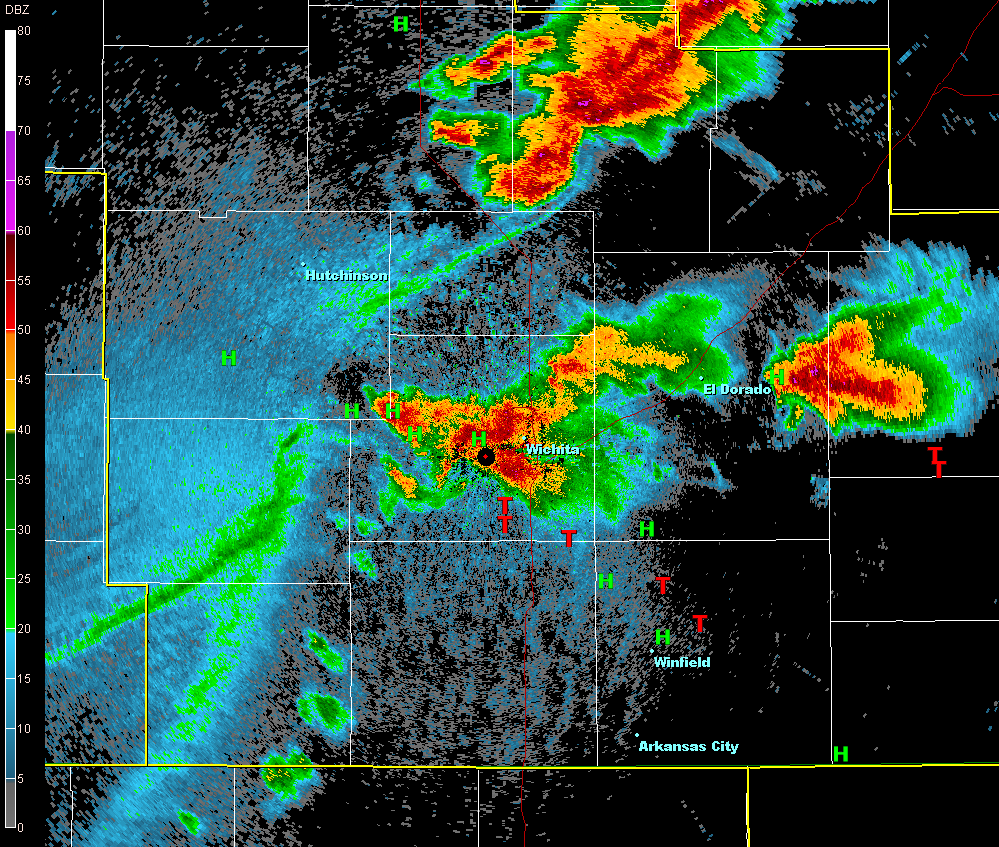
April 2-3rd 2015 Damaging Straight line wind event, Hail and Tornadoes


http://www.weather.gov/ict/April_2_3_2015_WindEvent

Severe thunderstorms developed rapidly and became supercellular on the evening of April 2nd across far southeast Kansas and produced two brief tornadoes in Labette County. As the initial storms continued to move southeast into Oklahoma and Missouri Thursday night, a severe thunderstorm developed near the border of Colorado and Kansas. This severe thunderstorm continued to develop and intensify across central Kansas and took on bow echo-like characteristics. This bow-echo later produced damaging straight-line winds and large hail across much of central and south central Kansas. As the bow-echo approached Sedgwick and Harvey counties, channeled microbursts developed and caused significant straight-line wind damage.

National Weather Service Weather Forecast Office


http://www.srh.noaa.gov/tsa/?n=weather-event_2015mar25

Severe thunderstorms developed late in the afternoon on March 25, 2015 near a warm front that had surged north into northeast Oklahoma and northwest Arkansas. With a highly sheared and unstable air mass in place across the area, discrete supercells were able to develop near the warm front late in the afternoon and into the early evening hours. Several tornadoes were spawned from the supercells from west of Tulsa into northwest Arkansas. As the evening wore on, a cold front surged into the area from the northwest and thunderstorms congealed into a line along the cold front marching to the south and east during the evening and overnight hours. 

Nepal Earthquake Death Toll Tops 4,000

ASSOCIATED PRESS
http://www.huffingtonpost.com/2015/04/26/nepal-earthquake-death-toll_n_7148726.html

Pierre-Anne Dube, a 31-year-old from Canada, has been sleeping on the sidewalk outside a hotel. She said she's gone from the best experience of her life, a trek to Everest base camp, to the worst, enduring the earthquake and its aftermath.
"We can't reach the embassy. We want to leave. We are scared. There is no food. We haven't eaten a meal since the earthquake and we don't have any news about what's going on," she said.
The earthquake was the worst to hit the South Asian nation in more than 80 years. It and was strong enough to be felt all across parts of India, Bangladesh, China's region of Tibet and Pakistan. Nepal's worst recorded earthquake in 1934 measured 8.0 and all but destroyed the cities of Kathmandu, Bhaktapur and Patan.
The quake has put a huge strain on the resources of this impoverished country best known for Everest, the highest mountain in the world. The economy of Nepal, a nation of 27.8 million people, relies heavily on tourism, principally trekking and Himalayan mountain climbing.

Wednesday, April 22, 2015

Space technology investigates large-scale changes to Africa's climate

http://www.brightsurf.com/news/headlines/106847/Space_technology_investigates_large-scale_changes_to_Africas_climate_.html

An international research team led by the University of Leicester has mapped the entire African continent south of the Sahara for geographical changes - and has discovered that many areas receive drastically different amounts of rainfall today compared to just ten years ago.

The study, which investigated the rainfall and greenness of plants in African regions using satellite mapping technology, suggests that areas such as the Congo, Nigeria and Madagascar now receive far less rainfall than they did a decade ago, while other locations such as the Sahel zone have become far greener through increased rainfall.

Together with the Joint Research Centre of the European Commission, the Institute of Electromagnetic Sensing of Environment of the National Research Council of Italy, and the Polish Institute of Geodesy and Cartography, the study analysed 10 years of satellite data.

Professor Heiko Balzter, Director of the Centre for Landscape and Climate Research at the University of Leicester and co-author of the study, said: "We looked at the satellite data and discovered a number of surprising hotspots of change. Some parts of the Congo, Nigeria and Madagascar appear to receive much less rainfall now compared to 10 years ago. This is an issue even in the wet tropics of the Congo, where low rainfall means restrictions to ship movements on the rivers there, which are the main transport routes in the dense jungle

Heat waves becoming more prominent in urban areas, research reveals

http://www.brightsurf.com/news/headlines/105706/Heat_waves_becoming_more_prominent_in_urban_areas_research_reveals_.html

The frequency of heat waves has increased dramatically over the past 40 years, and the trend appears to be growing faster in urban areas than in less-populated areas around the world, a new study suggests.

"Our findings suggest that urban areas are experiencing a kind of double whammy -- a combination of general climatic warming combined with the heat island effect, wherein human activities and the built environment trap heat, preventing cities from cooling down as fast as rural areas," said Dennis Lettenmaier, a co-author of the study and a UCLA geography professor. "Everything's warming up, but the effect is amplified in urban areas."

Lettenmaier and his co-authors studied 217 urban areas across the globe and found that prolonged periods of extreme heat increased significantly in 48 percent of them between 1973 and 2012.

The results, which were published today in the journal Environmental Research Letters, show that about only 2 percent of those urban areas experienced a significant decline in heat waves. And the change was more dramatic at night: Almost two-thirds of the urban areas showed significant increases in the frequency of extremely hot nights.

"The fact that the trend was so much stronger at night underscores the role of the heat island effect in urban areas," Lettenmaier said. "You have heat being stored in buildings and in asphalt, concrete and other building materials, and they don't cool down as quickly as they would outside of the urban area. This effect was likely exacerbated by decreasing wind in most of the urban areas."

Dozens feared dead after Cyclone Pam hits Vanuatu

From left to right: Cyclone Olwyn in the Indian Ocean, Cyclone Nathan north-east of Queensland, Australia, and Cyclone Pam near Vanuatu - 11 March 2015
http://www.bbc.com/news/world-asia-31865001


Cyclone Pam battered Vanuatu with winds of up to 270kph (170mph).
Pictures on social media showed buildings badly damaged and trees and power lines down.
Authorities on the islands had earlier issued a red alert to residents after the cyclone changed direction and began moving towards populated areas.
Communications have been knocked out over a wide area and aid agencies said on Saturday it could be several hours before a clear picture emerges.
Although thousands of people spent the night in emergency shelters, many more were forced to ride out the storm in their own homes.
Pam had already caused major damage on other Pacific islands, including Kiribati and the Solomon Islands.
Tuvalu, a group of nine tiny islands north-east of Vanuatu, has also declared a state of emergency after the cyclone caused flash floods there.

April 19-20, 2015 Severe Weather Event


http://www.srh.noaa.gov/ffc/?n=20150420_severe_weather

April 19 and 20, 2015 were active in terms of severe weather across north and central Georgia. On Sunday, April 19, 2015 a wedge front lifted northward as a low pressure system tracked across the Tennessee Valley and pushed a weak surface trough across the southeast. This put north and central Georgia in the warm sector, and storms quickly developed Sunday morning. Many of the storms observed on radar this day had rotation in them, but only a few produced tornadoes – one each in Chattahoochee, Sumter, and Laurens Counties. The main damage from the storms on Sunday turned out to be wind damage and was spread across northwest and central Georgia. Another active day occurred on Monday, April 20, 2015, as a cold front pushed through Georgia. The severe storms were confined to north Georgia and were generally just ahead of the cold front. Damage Monday once again included wind damage, but in addition hail was widespread across the northern Atlanta metro area. Reports received by the National Weather Service indicated golfball sized hail was the largest observed on April 20. Additional information will be added as it becomes available.

South Texas High Wind Event from a Gravity Wave - April 9, 2015


http://www.srh.noaa.gov/crp/?n=gravitywave_040915

A meteorological phenomenon called a "gravity wave" affected portions of South Texas during the early monrning hours on April 9, 2015. It originated from thunderstorms over the Sierra Madre which developed during the evening hours on April 8, 2015. Wind gusts between 30 and 50 mph were observed from Laredo to Bob Hall Pier between 1137 PM on April 8th through 330 AM on April 9th. The strongest winds occurred in Laredo, Kingsville, and Bob Hall Pier where all 3 stations reported 50 mph wind gusts. Both Corpus Christi International Airport and the Navy Base in Corpus Christi reported wind gusts of 40 mph between 211 AM and 314 AM on April 9th.

South Texas Severe Weather Events - April 12-14th, 2015

http://www.srh.noaa.gov/crp/?n=severe_april12-14_2015

A strong subtropical jet stream along with embedded upper level disturbances persisted across South Texas and Mexico between April 12th through April 14th, 2015. Meanwhile, abundant moisture and a very unstable airmass interacted with the strong jet stream and several upper level disturbances to produce 3 separate rounds of severe weather across South Texas during this time period.
The first event began in the late evening on April 12th and continued through the early morning hours on April 13th. This event began with moisture increasing across South Texas. Surface temperatures were warm in the low to mid 80s, while mid and upper levels of the atmosphere were cooler than normal, which led to a very unstable environment. As an upper level disturbance moved across Mexico toward South Texas, storms developed along the Sierra Madre in Mexico. These storms organized into a squall line as they entered South Texas. Wind gusts of 30 to 50 mph with isolated 60 mph wind gusts occurred along and behind this squall line. Isolated wind damage and localized flooding did occur with this squall line. The squall line eventually pushed offshore and weakened in the early morning hours on the 13th.

Warm Water and Strange Weather May Be Connected

Warm Water and Strange Weather May Be Connected
http://earthobservatory.nasa.gov/IOTD/view.php?id=85714

The weather in North America, particularly in winter, has been unusually extreme for much of the past two years. The western half has endured record-setting heat and, in many places, persistent and debilitating drought. The eastern half of North America has faced record cold and snow.
The causes are complex and have provoked lively discussion in the scientific community. Are ocean circulation and warming patterns in the Pacific altering atmospheric patterns over land? Or are atmospheric conditions driving the unusual conditions in the water? Are these short-term anomalies or decades-long changes at work? The answer has yet to be teased out, but it is probably a muddle of all of these things.
One thing is clear: the eastern Pacific Ocean has been warmer than normal since the winter of 2013–2014. The maps above show sea surface temperature anomalies in the Pacific in April 2014 (top) and March 2015 (bottom). The maps do not depict absolute temperatures; instead, they show how much above (red) or below (blue) water temperatures were compared to the long-term average from 2003 to 2012.

Grand clouds: Unusual weather event enchants with odd, undulating clouds over Teton Range

Rare, undulating clouds enchant visitors in Grand Teton
http://trib.com/news/state-and-regional/grand-clouds-unusual-weather-event-enchants-with-odd-undulating-clouds/article_26f20a99-97e9-5bb8-8dd8-e57d85dad4ff.html

Drivers stopped along the park's main highway Thursday morning to gaze in awe and shoot photos of the rare phenomenon hovering over Grand Teton mountain. At 13,775 feet above sea level, the Grand Teton is the highest point in the Teton Range.
They were lenticular clouds, a type that forms downwind of mountain ranges in certain conditions. Occasionally, lenticular clouds occur as perfectly symmetrical disks, appearing like giant flying saucers and prompting UFO reports.
These particular lenticular clouds resulted from an unusual combination of strong wind and moisture between 13,000 and 14,000 feet, said Riverton-based National Weather Service meteorologist Chris Jones, who got wind of the event from several weather spotters.

Unusual Weather Pattern Freezes Europe, Shifts Arctic Ice


http://www.climatecentral.org/blogs/unusual-weather-pattern-freezes-europe-moves-ice-out-of-arctic

The open water, located in the Barents and Kara Seas, led one blogger to claim that the developments are “unprecedented” in the satellite era (since 1979), and that the winter buildup of Arctic sea ice had ground to a halt this year — possibly leading to a record low maximum sea ice extent for the winter season.
        
Neven Acropolis, who writes the Arctic Sea Ice blog, wrote in a guest post for Climate Progress, “I think it’s safe to say that this is unprecedented ever since satellites started monitoring Arctic sea ice in 1979 . . . It’s almost as if the melting season has already started in the Barents and Kara Seas, more than two months earlier than normal.”
That’s not the case, though, according to sea ice expert Walt Meier of the National Snow and Ice Data Center (NSIDC) in Boulder, Colo. “I can’t say it’s unprecedented, but it’s certainly not something that we see regularly” during the winter, Meier said. “I wouldn’t be surprised if it’s happened before.”

'Warm blob' in Pacific Ocean linked to weird weather across the US


http://www.sciencedaily.com/releases/2015/04/150409143041.htm

A long-lived patch of warm water off the West Coast, about 1 to 4 degrees Celsius (2 to 7 degrees Fahrenheit) above normal, is part of what's wreaking much of this mayhem, according to two University of Washington papers to appear in Geophysical Research Letters, a journal of the American Geophysical Union.
Ten months later, the blob is still off our shores, now squished up against the coast and extending about 1,000 miles offshore from Mexico up through Alaska, with water about 2 degrees Celsius (3.6 degrees Fahrenheit) warmer than normal. Bond says all the models point to it continuing through the end of this year.
The new study explores the blob's origins. It finds that it relates to a persistent high-pressure ridge that caused a calmer ocean during the past two winters, so less heat was lost to cold air above. The warmer temperatures we see now aren't due to more heating, but less winter cooling

Odd weather pattern baffles experts: US lately lurches from lots of tornadoes to unusual quiet

Tornado Boom Or Bust.JPEG
 
http://www.foxnews.com/us/2014/04/30/odd-weather-pattern-baffles-experts-us-lately-lurches-from-lots-tornadoes-to/

Tornadoes can occur any time of year. All it takes is the right conditions. It varies by location, but the season tends to run from spring to mid-summer, with the biggest hotspots in Texas, Kansas, Oklahoma, Florida and Nebraska.
In the past few decades, the U.S. has averaged annually about 1,250 tornadoes of all sizes. Longer trends also show more tornado clusters recently. The number of days with at least one significant tornado is going down.
In the early 1970s, there was a single tornado about 150 days a year. Now it's about 100, said Harold Brooks, a meteorologist at the National Severe Storms Lab in Norman.
But the number of super-busy days with 30 tornadoes or more has gone up. In the 1970s, they came once every two years or so. Now we get those days three times a year, Brooks said.


Monday, April 6, 2015

2014 was warmest year on record for much of Alaska


http://www.adn.com/article/20150105/2014-was-warmest-year-record-much-alaska


On a day when many Interior Alaska towns and villages watch temperatures approach minus 40 degrees and Anchorage nearly dips to zero, it may seem counterintuitive to discuss warmth in the 49th state.
However, what transpired in 2014 is already the subject of considerable discussion among climate scientists. Over the weekend, the National Weather Service in Alaska noted that a number of cities across the state with long-term record keeping saw their warmest year on record in 2014.
Nearly every station west of a line from Anchorage to McGrath to Barrow observed its first-, second- or third-warmest year on record.
McGrath, Kotzebue, Nome, Bethel, King Salmon, Cold Bay and Homer all finished 2014 in first place. Anchorage just missed.


January Temperatures Leave Nation Confused With Hundreds Of Record Highs And Lows

cc
http://www.huffingtonpost.com/2014/02/03/january-temperatures_n_4718228.html

Overall, monthly records as well as average temperatures paint a similar picture. There have been 43 monthly record highs set to-date in January. Meanwhile, there have been 60 monthly record low maximum temperatures. And a map from the High Plains Regional Climate Center shows a large splash of average temperatures 6°-10°F below normal for the month and similar, though smaller areas where average temperatures have been 6°-10° above normal.
This pattern comes on the heels of a year when record lows outpace record highs in the U.S. for the first time since 1993. But before assuming the same pattern will continue this year, it's worth looking back at where we were last year. On January 30 last year, few would've predicted record lows would outpace highs. By that date, 2,132 record daily highs had been set or tied while only 1,232 record for lowest daytime highs were set or tied.

Monday, February 9, 2015

India Cyclone Leads to Blizzard in Nepal That Leaves at Least 27 Dead

Storm Track

http://mashable.com/2014/10/16/india-cyclone-hudhud-nepal/

When Category 3 Tropical Cyclone Hudhud came ashore in India near the city of Visakhapatnam on Oct. 12, it did far more than just damage buildings and flood coastal areas, which are typical types of tropical cyclone damage. It also led to a natural disaster that is rarely associated with tropical cyclones: a deadly blizzard and associated avalanches.
The blizzard struck Nepal on Tuesday on the Annapurna circuit, a popular hiking route that is not as demanding as the Mount Everest trek. As a result, many of the climbers may not have been the elite mountaineers, who have more experience in challenging conditions. So far, 27 people, including many foreigners, are confirmed dead, with at least 70 people still missing. The death toll is expected to rise.
The cyclone hit during the height of the annual mountaineering season, when adventurers from around the world attempt to climb the tallest peaks. Typically, the weather in mid-October is clear and cool, so the blizzard likely caught climbers and their guides, known as sherpas, off guard. The blizzard followed heavy rains that fell in Nepal, which also may have been related to the cyclone.

Heavy Snow Keeps Falling in Buffalo Area, Straining Nerves and Roofs


http://www.nytimes.com/2014/11/21/nyregion/snowstorm-western-new-york.html


LANCASTER, N.Y. — Jack Fasanella and Pattie Higgins had not seen another soul, aside from each other, for days.
So when a break came on Thursday, the couple gazed across the carpet of snow five feet deep that blanketed their lawn in this Erie County town and kept them trapped since Monday night.
And then they prepared for more.
“This is western New York; we’re used to it,” Mr. Fasanella, 62, a lifelong Buffalonian, said. “But this is the worst I’ve ever seen. Even worse than the blizzard of ’77.”
Across Buffalo and especially in its southern and eastern suburbs, people were reeling from the storms that by Thursday evening had claimed 10 lives. At least one nursing home was evacuated. Roofs were buckling. And with a state of emergency declared by Gov. Andrew M. Cuomo, rescue crews from as far away as Long Island were converging to help the area dig out.