Showing posts with label Krisma Patel. Show all posts

Sunday, November 15, 2015

Aleutians Cyclone Undergoes Bombogenesis; Multiple 90-MPH Gusts Reported

The latest in a series of potent non-tropical cyclones intensified explosively Tuesday night as it began moving through Alaska's Aleutian Islands. The storm has already brought measured wind gusts exceeding 90 mph at several locations in Alaska, causing considerable damage.
The storm, whose origins can be traced at least as far back as eastern China, brought rain and mountain snow to Japan earlier this week before racing northeastward over the northwest Pacific Ocean toward the Aleutians, a chain of islands extending so far west that some of them are in the Eastern Hemisphere.As it approached the far western Aleutians, it began undergoing a period of rapid intensification, as measured by its minimum central pressure – a key factor in determining the winds that a cyclone (tropical or non-tropical) can produce.
The central pressure fell from 992 millibars at 4 a.m. Alaska time Tuesday to 964 millibars at 4 a.m. Wednesday, a drop of 28 millibars in 24 hours. This qualifies the cyclone as a "bomb" – a term generally applied to a storm whose minimum pressure drops at least 24 millibars in 24 hours.
In recent years, some meteorologists have begun referring to the process of rapid intensification as "bombogenesis," mimicking the more generic meteorological term "cyclogenesis" used to denote the development of any low-pressure area, regardless of strength.

Current Enhanced Satellite

Peak Reported Wind Gusts

http://www.wunderground.com/news/aleutians-low-pressure-bombogenesis-alaska-november-11-2015

'November Witch' Storm Brings High Winds to Great Lakes, Plains, Midwest (FORECAST)

On par with past storms, known locally as the "witches of November" and virtually on the exact date of the storm that sunk the iron ore freighter Edmund Fitzgerald 40 years ago, a powerful low-pressure system has spread a swath of high winds through the Plains, Upper Midwest, Great Lakes, Ohio Valley and Northeast, that will persist in some areas through Friday.
The low's central pressure bottomed out at 984 millibars (29.06 inches of mercury) near Alpena, Michigan, early Thursday afternoon, the sign of a strong mid-latitude cyclone.
Due to the pressure difference between the cyclone's low pressure and a zone of high pressure over the northern Rockies, strong damaging winds have developed.
Wind advisories have been issued by the National Weather Service for parts of the Appalachians and portions of western and Upstate New York near Lakes Erie and Ontario.
Wind gusts up to 55 mph are possible in these areas. Such winds developed over a large part of the Plains Wednesday and spread across the Midwest and Great Lakes on Thursday.
In addition, other impacts are possible as this windstorm continues:
  • Large waves on the Great Lakes could result in some coastal flooding, including beach and dune erosion on downwind lakeshores.
  • Some flight delays are possible due to the winds, particularly at Chicago-O'Hare Airport. This includes some Northeast hubs including Newark-Liberty, where winds won't be as strong, but have been known to trigger flight delays.

http://www.wunderground.com/news/november-witch-wind-storm-great-lakes-midwest-nov2015

Winter Storm Will Impact Rockies and High Plains This Week

A southward dip in the jet stream will bring snow from the Washington Cascades to California's Sierra Nevada and even the mountains of Southern California as we close out the weekend.
(MORE: Heavy Rain, Flood Threat Targets Pacific Northwest)
This system will then intensify as it slides eastward through the Rockies and into the central Plains early this week. As this happens, snow will spread throughout the Rockies and into the Highs Plains. Increasing winds from the strengthening storm could lead to blizzard or near-blizzard conditions in the High Plains Monday night into Tuesday.
In fact, this system has some potential to become the first named winter storm of the season and it would be given the name Ajax.
The biggest forecast uncertainty, right now, apart from all the typical small-scale details typical in most Front Range snow events, is the speed of this system.
Previous forecast model runs had a slower-moving upper-level system, which is conducive for much heavier snowfall along the Front Range and adjacent High Plains of Colorado, southeast Wyoming, western Nebraska, far western Kansas and far northern New Mexico.
However, recent forecast model runs, including ensembles of models used to diagnose uncertainty, are now moving this bullish upper-level system a bit faster across the High Plains, which would cut down the duration of snow, and, thus, the total accumulations.
It is still too soon to rule out a slower, heavier snowstorm in the High Plains, as we are still roughly two days away from the event, however, the majority of our forecast guidance and trends are now steering away from a widespread, crippling blizzard with feet of snow. 
That said, some heavy snow will fall along the Front Range and High Plains of eastern Colorado, western Kansas, possibly into parts of northeast New Mexico, the Oklahoma panhandle and far northern Texas panhandle.


http://www.wunderground.com/news/winter-storm-snow-plains-rockies-denver-november-2015

Major Flash Flood Threat Looms From Gulf Coast to Mississippi Valley

For the third time in less than a month, a threat of flash flooding looms in parts of Texas and Louisiana in the week ahead. This time, however, the flood threat will be much more expansive, extending north into the Mississippi and Ohio Valleys.
Ahead of an intense area of low pressure aloft sliding through the South in the week ahead, a plume of deep, tropical moisture will be tapped not just from the Gulf of Mexico, but also from the western Caribbean Sea and eastern Pacific Ocean south of southern Mexico's Coast.
This deep moisture is expected to eventually be pulled as far north as Hudson Bay, Canada, over 3,000 miles from its source region, quite anomalous by mid-late November standards. In fact, senior meteorologist Stu Ostro noticed well above-average atmospheric moisture values may extend to the North Pole thanks to this pattern.
By Tuesday or Wednesday, a measure of available moisture in the atmosphere known as precipitable water may reach record November levels in parts of the Great Lakes and Upper Midwest, including parts of Michigan, Wisconsin and Illinois.
Simply put, it will feel quite humid for mid-late November in these areas ahead of the aforementioned storm system.


Upper-Level Pattern, Moisture Setup Wednesday
http://www.wunderground.com/news/flood-threat-texas-louisiana-mississippi-valley-november-2015

Strongest El Niño in 18 Years to Peak in Winter, Weaken In Spring, NOAA Says

"The strongest El Niño in 18 years continues to intensify and is likely to be one of the three strongest on record by the time it peaks this winter, according to a monthly outlook from NOAA released Thursday morning.
This El Niño is then expected to weaken in the spring, disappearing altogether by late spring or early summer 2016, the November El Niño diagnostic discussion from NOAA's Climate Prediction Center said.
El Niño is an anomalous, yet periodic, warming of the central and eastern equatorial Pacific Ocean. For reasons still not well understood, every two to seven years, this patch of ocean warms for six to 18 months.
Enlarge


    This warming of equatorial Pacific water influences the atmospheric pattern from the western Pacific Ocean, including Australia and Indonesia, to North and South America, the Atlantic Ocean, even parts of Europe and Africa.
    Precipitation and temperature impacts in the U.S. from a strong El Niño are typically most noticeable during the colder months, from late fall through winter. We have more on what those impacts are later in this article."
    http://www.weather.com/news/climate/news/strong-el-nino-noaa-update-november2015

    Category 5 Hurricane Patricia is Strongest Storm on Record in Eastern Pacific

    "While most people were sleeping, many meteorologists were awake and looking at the reconnaissance data coming in from the hurricane hunters flying through Hurricane Patricia.
    The data observed is jaw-dropping and record-breaking. Category 5 Hurricane Patricia now holds the record for lowest pressure in an East Pacific hurricane. The central pressure of the storm at 3 a.m. ET was 892 mb.
    **5am Update**
    Patricia now holds the record for strongest tropical cyclone ever recorded. It is worth noting that there have likely been typhoons in the West Pacific that are stronger -- Haiyan for example -- but unfortunately, no reconnaissance planes fly into those storms, so no exact measurements are ever taken.
    The storm has measured winds of 200 mph, with wind gusts of 245 mph. Central pressure is 880 mb. This is absolutely unbelievable."


    http://www.accuweather.com/en/weather-blogs/stormblog/category-5-hurricane-patricia-strongest-storm-on-record-in-eastern-pacific/53148530

    Monday, October 19, 2015

    Lando intensifies further, interacts with new typhoon

    Metro Manila (CNN Philippines) — Typhoon Lando intensified further as it threatened the provinces of Aurora, Isabela, and Northern Quezon on Saturday (October 17).
    It was spotted 230 km east of Baler, Aurora, packing winds of 175 kph, as of 4 p.m.
    State weather bureau PAGASA's acting Director Espie Cayanan warned that Lando might stay longer in the Philippine area of responsibility (PAR) because it was interacting with Typhoon Champi, which was spotted outside the PAR.
    "Habang hindi siya [Champi] tumataas at lumalayo, hindi makakagalaw si Lando," she said.
    [Translation: "Lando won't be able to move away as long as (Champi) remains near it."]
    It was likened to the weather conditions of 2009's Typhoon Pepeng, but PAGASA hoped it wouldn't be as devastating.
    The rainfall was expected to be heavy to intense within the 650 kilometer diameter of the typhoon.
    Lando is expected to make a landfall over Aurora area by Sunday morning (October 18).

    http://cnnphilippines.com/news/2015/10/17/Typhoon-Lando-LandoPH-Champi-PAGASA.html

    Lost at sea: Ship with 33 people missing in Hurricane Joaquin

    For more than 36 hours, there's been no word from, and no sign of, the U.S.-flagged container ship El Faro.
    That means no news on what's happened to the 28 Americans and five Poles aboard, faced with the full fury of Hurricane Joaquin and its up to 150-mph gusts, 30-foot waves and potentially 25 inches of rain.
      The U.S. Coast Guard dispatched a cutter ship, an MH-60 Jayhawk rescue helicopter and a C-130 Hercules airplane on Friday. But while the C-130 flew as low as 2,000 feet -- far below the normal 10,000 feet for such a storm -- it was not able to get close to the last known location off the Bahamas of El Faro, which means lighthouse in Spanish, much less spot or communicate with its occupants.
      "There's so much wind, thunderstorms and sea spray that it is difficult to see," Coast Guard Capt. Mark Fedor told CNN's Eric Burnett. "But our hope is that they are either on the vessel or on life rafts, and we can identify them."

      http://www.cnn.com/2015/10/02/us/hurricane-joaquin/

      South Carolina governor calls deadly rain a 'thousand-year' event

      South Carolina Gov. Nikki Haley didn't mince any words Sunday about just how dangerous a situation the weather -- which was blamed for five deaths in the state by Sunday night -- had become in her state. 
      "We are at a 1,000-year level of rain," Haley said at an afternoon news conference. "That's how big this is."
        It wasn't hyperbole. 
        Since weather records don't go back far enough to know if it's rained this much in South Carolina in a 1,000 years, a "thousand-year rainfall" means that the amount of rainfall in South Carolina has a 1-in-1,000 chance of happening in any given year, explained CNN meteorologist Taylor Ward.

        http://www.cnn.com/2015/10/04/us/east-coast-rain-flood/

        Nepal: Earthquake 2015 Situation Report

        As of 3 June (11:30, UTC+5:45), the Government reported a total of 505,745 houses destroyed and 279,330 damaged by the 7.8 magnitude earthquake on 25 April and the 7.3 quake on 12 May. The earthquakes killed 8,702 people (4,801 female; 3,899 male; 2 bodies remain unidentified) and injured thousands of people.
        An estimated 2.8 million people are still in need of humanitarian assistance. Reaching some 864,000 people in hard to reach areas who have lost their homes and live below the poverty line is a priority. With the impending monsoon rains expected to further isolate remote villages, district authorities and humanitarian partners continue to prioritize distribution of shelter materials in the northern-most Village Development Committees (VDCs).
        To date, some 762,000 people have received emergency shelter and non-food items (or about 40 per cent of the Shelter Cluster targets; refer to the Humanitarian Dashboard for a visual overview of progress towards meeting needs across other clusters).
        On 29 May, the Humanitarian Country Team revised the Nepal Flash Appeal seeking $422 million to ensure that life-saving assistance continue to reach people affected by the earthquakes.
        The appeal duration was extended from three to five months to take into account the effects of the monsoon on the emergency phase and to ensure linkage with the recovery and rehabilitation programme of the Government of Nepal.

        http://reliefweb.int/report/nepal/nepal-earthquake-2015-situation-report-no20-3-june-2015

        California mudslides leave state reeling as hundreds of cars remain stuck

        A section of southern California found itself waist-deep in mud as the weekend arrived, and a highway overtaken by flowing debris looked like a buried junkyard of hundreds of cars that would likely take days to dig up.
        The worst of the thunderstorms had passed, but the continued chance of rain could dampen cleanup and relief efforts in northern Los Angeles County’s Antelope Valley, where the most serious slides occurred.
        On Friday, rescuers and those stranded in the highway debris flow described a chaotic scene that somehow left no reported injuries or deaths.
        “It was terrifying,” 51-year-old Rhonda Flores of Bakersfield told the Associated Press. “It was a raging river of mud. I’ve never experienced anything like it, ever.”
        Rescuers threw ladders and tarps across mud up to 6ft deep to help the hundreds of trapped people from cars that got caught in the roiling river of mud along State Route 58 about 30 miles east of Bakersfield, a major trucking route, California highway patrol officials said.

        http://www.theguardian.com/us-news/2015/oct/17/california-mudslides-cars-stuck-photo-video-cleanup

        HEAVY SNOW WARNING: Worst El Nino in recorded HISTORY means UK faces winter WHITE-OUT

        Climate experts are now all but certain this year will see the strongest ever El Nino develop in waters around the Equator with serious consequences for the UK.
        When the phenomenon was announced earlier this year forecasters hoped it would fizzle out before winter.
        But temperatures in the Pacific Ocean have been rising steadily and the most powerful El Nino on record is expected to be confirmed within days.
        The knock-on effects around the globe, which include unusually cold winters in Britain, could be catastrophic.
        The last El Nino, six years ago, saw the UK crippled by the worst winter for decades with widespread harsh frosts, sub-zero temperatures and heavy snow setting in from early December and lasting until March.

        http://www.express.co.uk/news/weather/613168/UK-long-range-winter-weather-forecast-2015-snow

        South Carolina Flooding Shifts to the Lowcountry

        Dr. Matt Sitkowski, coordinating weather producer for The Weather Channel, calculated that if 12 inches of rain fell over the entire Palmetto State, that would equate to 6.68 trillion gallons of water. This is about 20,900 gallons of water for every American, or enough to fill the world's largest swimming pool 101,000 times over. 
        Now all that water is draining downstream. 
        South Carolina's elevation varies. The Blue Ridge Mountains touch South Carolina's far northwest, with elevations up to 3,560 feet.
        The state's rolling Midlands, the transition between the relatively more rugged Upstate and the Lowcountry, contributed to the destructive power of the flash floods.
        There is only a 272 foot elevation difference between Columbia – the state's capital in the Midlands – and Charleston on the Atlantic coast.
        http://www.weather.com/storms/severe/news/south-carolina-flood-forecast-oct2015

        'Popular' Orionid Meteor Shower to Peak in the Night Sky This Week

        The peak of the Orionid meteor shower is set for the night of Oct. 21 into the early morning hours of Oct. 22.
        "The Orionids are popular among stargazers because of all its individual shooting stars are fragments of the most famous comet of all time, Halley's Comet, which has the scientific designation of P1, meaning the first periodic (returning again and again) comet ever known," Slooh Astronomer Bob Berman said.
        The Orionid meteors are simply tiny bits of ice and dust that fell away from the comet and plowed into our atmosphere, according to Slooh, a community observatory that has connected telescopes to the Internet for public use.

        http://www.foxnews.com/weather/2015/10/18/popular-orionid-meteor-shower-to-peak-in-night-sky-this-week/

        Thunderstorms to Raise Flood Risk Across US Four Corners Into Midweek

        Showers and thunderstorms will continue to produce locally heavy rainfall across portions of the southwestern U.S. into Wednesday.
        "The storm system over the southwestern U.S. is pulling moisture from more humid areas and into the region, resulting in a significant increase in activity," AccuWeather Meteorologist Evan Duffey said.
        "Showers and thunderstorms across the area will be scattered but some could produce rainfall rates of 1 inch or more per hour," he said.
        While these thunderstorms will be spotty in nature, any thunderstorm can lead to flash flooding.
        This storm system will move slowly to the east through the week. This could lead to rounds of thunderstorms hitting the same areas for multiple days.
        "Flash flooding is always a concern in desert areas and isolated severe wind gusts are also a possibility," Duffey said.
        The shower and thunderstorm activity will not just be confined to the Four Corners states. Showers and a few thunderstorms will also target Nevada, Idaho, Wyoming and Montana into Tuesday.
        Dry weather will prevail over much of California this week. This storm system, however, may produce a spotty shower, mainly across the southeastern portion of the state.

        http://www.accuweather.com/en/weather-news/thunderstorms-flooding-southwest-four-corners/53072253

        El Nino-Spurred Warmth to Hang on Across Midwest, Northeast Into November

        Warm weather beginning to grip the Midwest and Northeast is expected to last well into November with only brief interruptions of cooler blasts of air. The warm pattern will spurred on by El Niño.
        El Niño is the warm phase of routine water temperature fluctuations in the tropical Pacific Ocean and can alter weather patterns around a large part of the globe.
        "The weather pattern in much of the Midwest and Northeast will feature more mild days than cool days from the middle of this week into early November," According to AccuWeather Long Range Meteorologist Ben Noll.
        The cold pattern and snow from last weekend had roots in north-central Canada. Strong winds aloft, or the jet stream, lined up with surface winds and allowed the cold air to quickly drain a couple thousand miles to the south.

        http://www.accuweather.com/en/weather-news/warmer-weather-midwest-northeast-el-nino-into-november/53079240

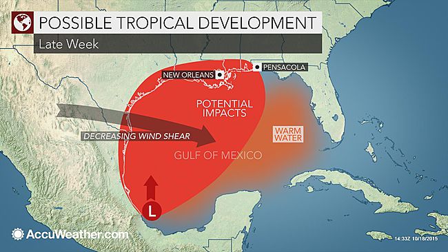
        Tropical Downpours to Stream Into Texas; Gulf of Mexico System May Develop

        Regardless of tropical development in the western Gulf of Mexico or not, a stream of tropical moisture into Texas will raise the risk of heavy rain and flooding starting later this week.
        Although the Atlantic has been quiet since Hurricane Joaquin, conditions in the Gulf of Mexico are showing signs that the tropical season may not be finished.
        In years of strong El Niño, it is rather difficult for tropical systems to strengthen in the Atlantic due to unrelenting wind shear; this has been the cause for less-than-normal activity during the 2015 Atlantic hurricane season.
        Wind shear is a rapid change in direction and speed of air flow at different levels of the atmosphere. Wind shear can prevent a tropical system from forming and cause an organized tropical system to weaken.


        http://www.accuweather.com/en/weather-news/potential-tropical-development-1/53052102

        Typhoon Koppu Pounds Philippines, Killing At Least 12

        A slow-motion disaster is playing out in the northern Philippines, where thousands of residents still have days of life-threatening rainfall ahead.
        At least 12 people have died and six more are missing since the landfall of Typhoon Koppu (Lando) in the Philippines Sunday morning, local time, while flooding rains continue to lash parts of the country with torrential downpours. Koppu was downgraded to a tropical storm late Monday, but remains a deadly threat to the archipelago.
        "As expected, Koppu has stalled near Luzon in the northern Philippines," said weather.com meteorologist Chris Dolce. "Although its winds will continue to weaken, heavy rain will drench the region into at least Tuesday, leading to more dangerous flooding and possible mudslides."


        http://www.weather.com/storms/typhoon/news/typhoon-koppu-lando-philippines-impacts

        Sunday, September 13, 2015

        Tropical Storm Erika: Prime Minister Says Dominica's Progress Set Back 20 Years; At Least 20 Dead

        Tropical Storm Erika dissipated early Saturday, even as its remnants began drenching parts of eastern Cuba. But it left devastation in its path, reported The Associated Press, killing at least 20 people and leaving another 24 unaccounted for on the small eastern Caribbean island of Dominica, authorities said.
        During a televised address, Dominica Prime Minister Roosevelt Skerrit said Erika set the nation's developmental progress back 20 years, as hundreds of homes and multiple other structures were destroyed. 
        "I give you my pledge that we shall not cease until contact is made with every community and a full account is given of every single missing person. I take this opportunity on behalf of my dear wife, Melissa, the Cabinet of Ministers, the Government of Dominica and the Dominica Labour Party to extend to the bereaved, our deepest and most sincere condolences," Skerrit lamented.
        The melancholic prime minister vowed parliamentary representatives will meet with families who lost loved ones to plan and complete funeral arrangements, and those injured will receive the utmost care... 


        http://www.weather.com/safety/hurricane/news/tropical-storm-erika-preparations-caribbean-florida-impacts

        Baseball-Sized Hail Pummels Parts of Italy This Weekend

        According to Jonathan Erdman, senior meteorologist for weather.com, the storm was brought on by a vigorous southward plunge of the jet stream that carved into western Europe sending a potent upper disturbance into the Italian peninsula Saturday. 
        That instability then charged up thunderstorms over the Mediterranean Sea, which swept into Italy. "The satellite signature was classic for a severe thunderstorm, or cluster of storms."
        Social media posts recorded hail near Lake Como in Northern Italy as well as the in the Naples area.
        Enlarge

        A massive hailstone found near Pozzuoli, Italy.  (Instagram/barber8813)
          "Baseball size hailstones fall from thunderstorms at speeds of at least 75 mph, so it's no wonder you can see the magnitude of smashed windshields and structural damage," said Erdman...

          http://www.weather.com/storms/severe/news/baseball-hail-italy-pozzuoli-naples-sep2015