Showing posts with label Michael Conrardy. Show all posts

Tuesday, April 16, 2013

Risk of Flooding from Missouri to Michigan

Last year, much of the Midwest was bracing for a rough ride with building heat and drought.
The year before, the story was record-challenging flooding.
This year, concerns have again flipped to flooding. Areas with an ongoing or developing flood potential extend from portions of northern Arkansas and Missouri to Michigan.
Late winter and early spring storms have made up for snow and rain deficits, pushing streams to bank full and have major rivers running well above their near-record lows from the start of the year.

There have already been some flooding incidents and more are possible over the next couple of weeks.
Factoring in the rain that fell to start the week, and what may fall through the balance of the week, some locations may rack up 3 to 6 inches of rain during the period from Monday through Friday.


Link: http://www.accuweather.com/en/weather-news/risk-of-flooding-from-missouri/10419897

Severe Storms to Threaten Dallas to St. Louis

A major outbreak of severe thunderstorms is possible beginning Wednesday across the central and southern Plains. This could be one of the worst outbreaks of the year.
Cities with the greatest potential for severe weather into Wednesday night include Dallas, Wichita Falls, and Abilene, Texas, Oklahoma City and Tulsa, Okla., Chanute, Kan., and Joplin and Springfield, Mo., to name a few.

Extremely large hail to the size of baseballs is possible across these areas. Hail of this size can kill people and animals and cause extreme property damage.
In addition to tornadoes and very large hail, wind gusts associated with these storms could exceed 60 mph and, in some cases, reach speeds of up to 70 or 80 mph. Blowing dust, uprooted trees and toppled power poles are possible.


Link: http://www.accuweather.com/en/weather-news/midweek-severe-weather-threat/10272748

Monday, April 8, 2013

Winter Temps Hotter than Usual / Wetter

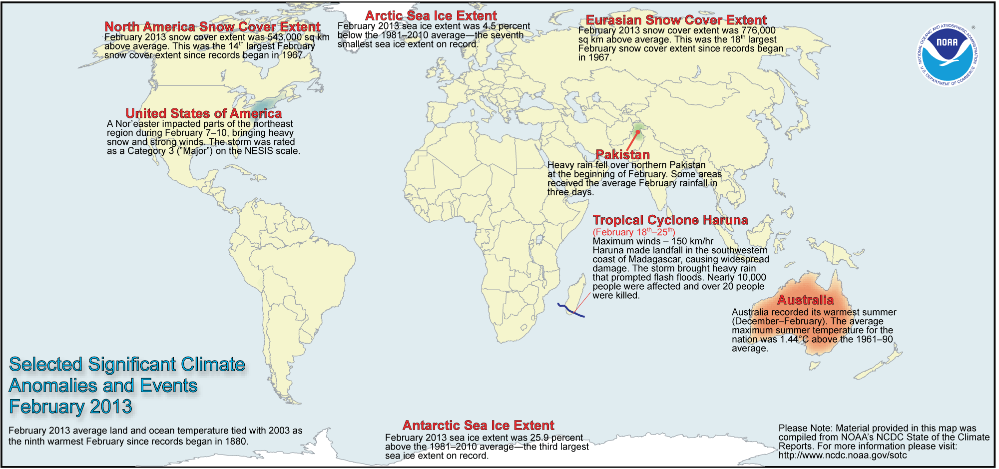
February Extreme Weather/Climate Events

Link: http://www.ncdc.noaa.gov/sotc/national/2013/2

Note: the picture says it all...

Spring Spoiler Possible: NYC, Boston


While temperatures will be on the rise across the Northeast and mid-Atlantic through Tuesday, how long the warmth lasts after that will depend whether cold or warm air wins an upcoming battle.
The warmth could last through most of the workweek ahead of the storm set to bring a blizzard to Denver and an outbreak of severe weather across the central and southern Plains.
Temperatures could soar into the 70s northward to Burlington, Vt., and into the 80s as far north as Pittsburgh, Philadelphia and Harrisburg, Pa., when the warmth peaks on Thursday.

Link: http://www.accuweather.com/en/weather-news/boston-nyc-dc-pittsburgh-tempe/9698102

Tornadoes, Hail and High Winds Target the Plains


The curtain will open Monday for a dangerous, multi-day severe thunderstorm outbreak across the nation as a major storm system emerges from the Rockies.
A few storms on Sunday across Kansas already brought hail up to the size of golfballs near Wichita. There was even a weak, rope-shaped tornado that damaged a barn and radio tower near Paradise.
Unfortunately, Sunday's severe storms were just a taste of what is to come this week.
Instead of cooler and drier air replacing Sunday's violent weather, the stage has become set for several widespread rounds of potentially damaging thunderstorms to erupt Monday afternoon, and continue pushing slowly eastward each day though midweek.

Link: http://www.accuweather.com/en/weather-news/multiday-severe-weather-on-pla/9764158

Land loss in coastal Louisiana since 1932

 
Every year, 25-35 square miles of land off the coast of Louisiana—an area larger than Manhattan–disappears into the water due to a combination of subsidence (soil settling) and global sea level rise. The maps above show how much land has been lost to the Gulf of Mexico in the past 80 years.
 
The first image shows the state of the coast in 2011. Based on a NASA satellite image, gray and white areas show land and blue indicates open water. New land—mainly coastal improvements such as shoreline revetments and enriched beach areas—that built up since 1932 is shown in green.
 
 
Note: Please view the link to see the images. They were too large for the page.
 
Thanks, Mike.

Tuesday, April 2, 2013

Febuary Temperatures Highest on Record

  • The combined average temperature over global land and ocean surfaces for February 2013 tied with 2003 as the ninth warmest on record, at 0.57°C (1.03°F) above the 20th century average of 12.1°C (53.9°F).
  • The global land surface temperature was 1.00°C (1.80°F) above the 20th century average of 3.2°C (37.8°F), tying with 2010 as the 11th warmest February on record. For the ocean, the February global sea surface temperature was 0.42°C (0.76°F) above the 20th century average of 15.9°C (60.6°F), making it the eighth warmest February on record.
  • The combined global land and ocean average surface temperature for the December–February period was 0.51°C (0.92°F) above the 20th century average of 12.1°C (53.8°F), making it the 12th warmest such period on record.
  • The December–February worldwide land surface temperature was 0.71°C (1.28°F) above the 20th century average, tying with 1992 as the 15th warmest such period on record. The global ocean surface temperature for the same period was 0.43°C (0.77°F) above the 20th century average and was the eighth warmest such period on record.
  • The combined global land and ocean average surface temperature for the January–February period (year-to-date) was 0.56°C (1.01°F) above the 20th century average of 12.1°C (53.8°F), 
  •  tying with 2005 as the ninth warmest such period on record.
     
    Link: http://www.ncdc.noaa.gov/sotc/global/2013/2 

Moscow Records Highest March Snow Depth in 20 Years

As of March 26, 2013, the snow depth in Moscow, Russia, was 30 inches, their highest March snow depth in more than 20 years.
"A previous record snow depth of 29 inches was recorded March 19, 1994," said Senior Expert Meteorologist Jim Andrews.
In early February, following a big outburst of snow, reports from Interfax (the Russian news service) stated the snowfall had reached 85 inches. Normal snowfall for Moscow is 60 inches.
The Moscow Times reported that Moscow is having their coldest March since the 1950s. Colder temperatures there this spring have prevented the birds from migrating north from their wintering grounds.

Link: http://www.accuweather.com/en/weather-news/moscow-records-highest-march-s/9128535


Coldest Easter on Record in United Kingdom

The lowest Easter temperature in recorded history across the United Kingdom occurred in Braemar, Scotland, as the temperatures fell to -12.5 C (9.5 F) Sunday. This broke the previous record of -9.8 C (14.4 F) set in 1986, according the the Met Office.
Meanwhile, the low temperature fell to -2.8 C (27 F) in London, well below the normal low of 3.9 C (39.0 F).
The cold comes as no surprise to anyone in the United Kingdom as March has been very cold with frequent snow. The Met Office reported through March 26 that the average temperature across the entire United Kingdom was 2.5-3.0 C below normal, on pace to be the coldest March since 1962.

Link: http://www.accuweather.com/en/weather-news/coldest-easter-on-record-in-un/9247135


Chicago: Coldest April Fools' Day Since 1993

The arctic air plunging into the Midwest is leading to the coldest April Fools' Day in years, even decades for some.
Easter Sunday went down in history books as a chilly one for the Upper Midwest due to the arctic air's arrival, while temperatures remain mild across the eastern Great Lakes and Ohio Valley.
A noticeably colder Monday is on tap for the rest of the Midwest as the cold blast continues its journey to the south and east, eventually leading to dramatic changes for the Northeast's I-95 corridor and the southern Plains by Wednesday.
Highs on Monday will range between 40 and 45 degrees along the I-70 corridor from St. Louis to Indianapolis to Columbus, but will be held to the 30s across the Great Lakes.

Link: http://www.accuweather.com/en/weather-news/coldest-april-fools-day-in-20/9111879

Monday, March 11, 2013

Tropical Cyclone Sandra

Tropical Cyclone Sandra was still a very strong storm, hovering at sea northwest of New Caledonia on Monday.

While far to the east of Australia, Sandra was helping to whip up rough surf and rip currents, which will be likely to last through at least Wednesday, along some Queensland beaches.

Sandra had begun to weaken after having peaked in strength on Sunday. However, its top winds were still near 100 mph on Monday, according to tropical cyclone forecasters in Fiji.

Over the weekend, Sandra had rapidly intensified; the storm's top sustained winds hit 125 mph with gusts nearing 155 mph.


Link: http://www.accuweather.com/en/weather-news/tropical-cyclone-sandra-churns/7832174

January 2013 global temperatures were ninth highest on record

January 2013 global temperatures were ninth highest on record


The globally-averaged temperature for January 2013 tied with 1995 as the ninth warmest January since record keeping began in 1880. January 2013 also marks the 37th consecutive January and 335th consecutive month with a global temperature above the 20th century average.

Most areas of the world experienced higher-than-average monthly temperatures, including Alaska, the eastern United States, southern Greenland, Uzbekistan, and Australia. Meanwhile, far northwestern and central Canada, the western United States, and a large swath of northern Eurasia were most notably cooler than average.

January 2013 Selected Climate Anomalies and Events Map
January 2013 Selected Climate Anomalies and Events


Link: http://www.ncdc.noaa.gov/sotc/

Tuesday, February 19, 2013

Warmer and Wetter than Avg January


Contiguous U.S. warmer and wetter than average for January

Drought persists for central U.S.; above-average January snow cover extent for Lower 48
The average temperature for the contiguous U.S. during January was32.0°F, 1.6°F above the 20h century average, tying with 1958 as the 39th warmest January on record.
The January nationally-averaged precipitation total of 2.36 inches was 0.14 inch above the long-term average. The January precipitation average masked both wet and dry extremes across nation. Drought conditions remained entrenched across the Southeast, Great Plains, and the mountainous West.
Significant U.S. Climate Events for January 2013
Link: http://www.ncdc.noaa.gov/sotc/

Major Southwest Storm


As a major storm swings out of the Southwest, there is the potential of violent thunderstorms sweeping from western Texas to the lower Mississippi Valley during the middle of the week.
The setup has the potential to bring a significant severe weather outbreak, by way of a developing squall line.
The most common characteristics of the severe thunderstorms will be damaging wind gusts, hail and blinding downpours. However, a few of the storms will bring the potential for a tornado.
Tornadoes could occur during the early stages of the developing squall line or in isolated storms ahead of the squall line.
Link: http://www.accuweather.com/en/weather-news/midweek-severe-weather-texas-to-miss/6401028

Monday, February 11, 2013

Heavy snow fell over northern Italy Monday, even reaching the shores of the Mediterranean Sea.
Snow covered such northern cities as Milan, Torino, Piacenza and Parma.
By Tuesday, there is potential for snowfall accumulations of at least 6 inches in the lower elevations, with amounts to at least 12 inches over hills. AccuWeather.com meteorologists expect 6-10 inches of snow will fall in Milan.
Snow also fell in Venice.
Snow fell heavily as of early Monday afternoon, cutting visibility to between 1/4 and 1/2 of a mile in the Lombardy Plain, the flat, fertile valley at the heart of northern Italy.

Link: http://www.accuweather.com/en/weather-news/italy-snowstorm-unleashes-up-t/5990403

Major Eastern Snowstorm

There continues to be some indication that a major storm will affect the Eastern states and neighboring Canada this weekend. The storm would be part of a series of potentially major weather events through the end of February.
Part of the system that could produce a major storm along the East Coast this weekend (Feb. 16 and 17, 2013), was still over the northern part of the Pacific Ocean to start the week.
However, with the way cold air will plunge southward over the Central states this weekend may not only set up a corresponding northward storm track along the Atlantic Seaboard. It could cause the storm to strengthen rapidly as it moves up from the South.
It will be a matter of how quickly the storm strengthens to determine if heavy snow is thrown back over the Atlantic Seaboard or falls over Atlantic waters.

Link: http://www.accuweather.com/en/weather-news/weekend-storm-potential/5997763


Tuesday, February 5, 2013

San Fransico Has Driest January on Record

A lack of storms dipping to the south that started the year over California continues in the Bay Area.
San Francisco International Airport recorded only 0.20 of an inch of rain during January 2013, and as of Feb. 5, no rainfall has been added to this amount.
The prior driest January on record was in 1991, when 0.24 of an inch of rain fell.
A northward bulge in the jet stream, known as a ridge, delivered the dry weather much of the past five weeks.
Link: http://www.accuweather.com/en/weather-news/san-francisco-record-dry-start-to-year/5621528

Another weak low pressure has pushed out of southern Canada, bringing a swath of new snow to the Midwest Tuesday and adding to the parade of small storms that have been moving through.
These waves of energy, bringing smaller amounts of snow accumulations are called Alberta Clippers. They have been sprinkling fresh snow through the northern Plains, Great Lakes and mid-Atlantic since the end of January.
Snow started the day in Upper Michigan, Wisconsin, Iowa and Minnesota and was rolling across lower Michigan and into northern Illinois and Indiana during the afternoon.
But unlike the last few clippers that have pushed through the Great Lakes recently, the track for this storm is slightly farther north.

Link: http://www.accuweather.com/en/weath
er-news/more-clipper-snow-wisconsin-to/5605890