Showing posts with label Michelle Karlsson. Show all posts

Thursday, April 25, 2013

Sea Ice Loss Could Alter Arctic Air Chemistry

Andrea Thompson, OurAmazingPlanet.com Published: Apr 25, 2013, 1:48 PM EDT From our partners
Paul Shepson, Purdue University
Kerri Pratt, an National Science Foundation postdoctoral fellow, conducts a snow-chamber experiment in minus 44 degree Fahrenheit windchill near Barrow, Alaska.

Over the past 30 years, the Arctic has warmed more than any other place on the planet, and that warming and the resulting melt of the region's sea ice presents a number of potential adverse effects, from impacts on weather systemsto the decline in the habitats of native species.

Now, a team of scientists have found evidence that the Arctic warming and melting sea ice could be changing the chemistry of the Arctic atmosphere through reactions that happen on the snow that sits atop the sea ice and in the air above it. These reactions purge pollutants from the atmosphere and destroy toxic surface-level ozone (which differs from the protective ozone layer higher up in the atmosphere).

http://www.weather.com/news/science/environment/sea-ice-loss-20130425

Has the Drought Improved?

Jon Erdman Published: Apr 25, 2013, 2:09 PM EDT weather.com

Chipping Away at the Drought

Source: National Oceanic and Atmospheric Administration/U.S. Department of Agriculture/National Drought Mitigation Center
 
As of late April 2013, drought has been wiped out of the Ohio and mid-Mississippi Valleys, Alabama and most of Georgia. Drought improvement has also been noted in parts of the Plains and Rockies.
Above: These maps show drought status over the Lower 48 States. Click the Previous and Next buttons to see how drought conditions have changed.

We've had a series of winter storms produce heavy snow in parts of the Rockies and Upper Midwest.  In some locations, this snow set April records.

The Latest on the Drought

Then, flooding rainfall inundated parts of the Mississippi and Ohio Valleys.  Not exactly the kind of "drought relief" you'd like.

(FLOOD RECAPS:  Photos | News)

So, what, if any, impact has this recent heavy precipitation had on the massive drought spanning from the nation's heartland to the West?

http://www.weather.com/news/drought/drought-improvement-midwest-20130425

Confirmed: This is Chicago's Wettest April

Confirmed: This is Chicago's Wettest April

Official records indicate 8.54 inches of rain as of Wednesday

Wednesday, Apr 24, 2013  |  Updated 10:40 PM CDT


Confirmed: This is Chicago's Wettest April
Getty Images
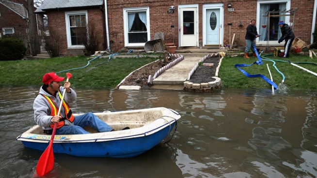
Octavio Castillo paddles a boat down a flooded street to reach the home of his cousin on April 19, 2013 in Des Plaines.

As if we really needed official confirmation, this is now the wettest April on record in Chicago, according to the National Weather Service.

The .70 inches of rain that fell at O’Hare International Airport on Tuesday brought the monthly total to 8.54 inches, a new monthly rainfall record, the weather service said.

The Top 5 wettest Aprils on record in Chicago are:
  • 2013 -- 8.54 inches
  • 1947 -- 8.33 inches
  • 1975 -- 7.84 inches
  • 1909 -- 7.73 inches
  • 1983 -- 7.69 inches

Source: http://www.nbcchicago.com/weather/stories/chicago-april-2013-wettest-ever-204607461.html#ixzz2RTkZqv00

Cold, wet weather slows fieldwork in Nebraska

USDA says cold, wet weather slowed fieldwork in Nebraska but helped moisture levels


LINCOLN, Neb. (AP) -- Recent cold, wet weather has slowed fieldwork in Nebraska as farmers get ready to plant crops and ranchers tend to their cattle. 

The U.S. Department of Agriculture said Monday that soil moisture levels improved in eastern Nebraska, but most of the western counties received less than half an inch of moisture last week. 

About 41 percent of the topsoil and 90 percent of the subsoil in the state rated short or very short on moisture.

http://news.yahoo.com/cold-wet-weather-slows-fieldwork-152825966.html

UN official hopeful about 2015 climate talks

DUBAI, United Arab Emirates (AP) — Governments are more serious and the impact of climate change is more dramatic, improving chances of a groundbreaking global warming pact in 2015 in contrast with the failure of such an effort in 2009, the U.N. climate chief said Tuesday.

The climate change talks in Copenhagen were a resounding failure, setting back the movement to control global warming. Even so, the U.N. official, Christiana Figueres, is optimistic, though she admits the world needs to step up its efforts to meet its goals.

A conference is set for Bonn next week, one of a series of meetings leading up to the next major climate convention in 2015.

http://news.yahoo.com/un-official-hopeful-2015-climate-talks-195618680--finance.html

Storms flood streets, damage houses across SE La.

NEW ORLEANS (AP) — A fast-moving line of intense thunderstorms has flooded streets, damaged houses and business and knocked out power to more than 30,000 people in southeast Louisiana.
No injuries were reported.

The New Orleans suburb if Kenner reported that a possible tornado damaged roofs and buildings and left numerous utility poles leaning. A building under construction was heavily damaged.

The utility corporation Entergy reported more than 32,000 customers without power around midday. Jefferson Parish had about 16,000 of those outages and New Orleans had more than 11,000. The total had been reduced to around 20,000 by mid-afternoon.

By early afternoon, the worst of the storms appeared to have moved out of heavily populated areas and into coastal marshes and waters.

Photos: April Flooding on the Mississippi River in Illinois Breaks

CARMAN, Ill. -- The Midwest floods in April have caused damage and disrupted lives in a widespread area. Here, on the Mississippi River in Carman, it was far bigger than it was expected to be, as it was elsewhere. Heavy thunderstorms in the beginning also brought it up much faster than anticipated. 

Though many people have evacuated, many of us have houses built on stilts, designed for these situations, so a few of us have held out at home. It isn't always easy to bear the water as it comes up under the house, rising to a record 22.3 feet (normal levels for this time of year are about 12.6), yet it is still better to be at home, for some.

More on this story here!
Tornado Central

Spectacular Spinning Storm (PHOTOS)

Nick Wiltgen Published: Apr 25, 2013, 7:31 AM EDT weather.com
 
Western Oklahoma Supercell - April 22, 2013 Near Arnett, Okla.
Near Arnett, Okla.

The Mother Ship is Landing!

 
Veteran storm chaser and photographer Roger Hill captured images of a spectacular supercell thunderstorm over western Oklahoma on April 22, 2013

A supercell thunderstorm is characterized by a sustained and powerful rotating updraft. These storms originate in unstable air accompanied by a particular type of changing wind direction at various altitudes in the atmosphere; a common combination supportive of supercells is a southerly or southeasterly wind near ground level and a southwesterly or westerly wind higher up in the atmosphere.

http://www.weather.com/news/tornado-central/spectacular-spinning-storm-photos-20130424


Two Tornadoes Confirmed in Louisiana Wednesday

Published: Apr 25, 2013, 6:21 AM EDT weather.com
An intense line of storms that moved through the New Orleans metro area around lunchtime damaged homes and ripped trees out of the ground.

The National Weather Service confirmed the storms spawned two tornadoes: An EF-1 in Kenner, La. and an EF-0 in Metairie, La. The Kenner tornado damaged several trees and produced moderate roof damage to several residences.  The Metairie tornado downed a tree onto a car, snapped small trees and overturned a large truck.

http://www.weather.com/news/severe-weather-south-20130424

Tornado Central

Tornado Drought 2013?

Jon Erdman Published: Apr 25, 2013, 7:38 AM EDT weather.com

Overlay

Georgia Tornado Up Close


You've probably heard about the widespread drought still in place over the nation's mid-section.
What about a drought most people love?  Over three weeks into April, it may be safe to say the U.S. is in a short-term tornado drought.
Background

U.S. Tornado Stats

According to Severe Weather Expert, Dr. Greg Forbes (Facebook | Twitter), only 64 tornadoes have touched down in the U.S. so far this April, according to preliminary data through April 24.

Over the past 10 years (2003-2012), the April average through April 22 is 187 tornadoes.  If the month ended already, it would be the quietest April, tornado-wise, since 1992, according to Dr. Forbes.

http://www.weather.com/news/tornado-central/tornado-drought-20130424

Tuesday, April 23, 2013

Earthquake Weather? Hurricane Irene May Have Triggered Tiny Temblors

Hot or cold, rain or snow, geoscientists say there's no evidence for earthquake weather. But the biggest storms are starting to prove them wrong.

The latest evidence for the link between earthquakes and major storms comes from Virginia, a state pummeled by Hurricane Irene in 2011. The storm hit just five days after the magnitude-5.8 Virginia earthquake, so hundreds of aftershocks were still rattling the state.

Deadly Colo. Avalanche Difficult to Predict

Colleen Slevin Published: Apr 23, 2013, 8:13 AM EDT Associated Press

Loveland Pass, Colo.

Loveland Pass, Colo.
An avalanche killed 5 people in Loveland Pass, Colo. on Saturday, April 20, 2013. The avalanche was on the western flank of Mount Sniktau. This is the path the avalanche took. Some of the blocks of snow are the size of small cars. (Photo By Helen H. Richardson/ The Denver Post)

Avalanche Kills Five, One Survives

DENVER -- The kind of avalanche that killed five people in Colorado over the weekend is among the most difficult to predict and trigger, and it's dangerous because of the amount of snow normally involved.

Saturday's slide in near Loveland Pass is called a deep persistent slab avalanche, and it was the kind of avalanche that backcountry snowboarders and skiers were warned of in the area that day. It's also the same type of avalanche that killed a snowboarder Thursday near Vail Pass.

Spring or Winter? Winter Storm Zeus Hits U.S.

weather.com & Associated Press Published: Apr 23, 2013, 10:42 AM EDT

Boulder, Colo.

Boulder, Colo.
Elementary school students are dropped off at class as Winter Storm Zeus dropped snow over Boulder, Colo., Tuesday April 23, 2013. The Colorado Avalanche Information Center says avalanche danger there is considerable. (AP Photo/Brennan Linsley)

Winter Storm Zeus hit the Northern Plains and Upper Midwest, leaving as much as a foot of snow in its wake. For the majority of the region, the late-season snowstorm was more of an oddity than anything else. But it's the latest in a round of snowstorms that have hit the region in recent weeks.

"Zeus piled on to what has been a very snowy and cold April in parts of the Rockies, northern Plains and Upper Midwest. Denver, Colo., Cheyenne, Wyo. and Minneapolis, Minn. are just a few of the locations that have dealt with multiple rounds of snow the last few weeks," says weather.com meteorologist Chris Dolce. "Duluth, Minn. and Rapid City, S.D. have seen so much snow that this is now the snowiest April on record."

http://www.weather.com/news/winter-storm-zeus-news-20130423

More Rain Expected for Already Swollen Rivers

Associated Press & Reuters Published: Apr 23, 2013, 2:04 PM EDT

Grand Rapids, Mich.

Grand Rapids, Mich.
A duck swims against a window, viewed from inside Anderson Eye Care at the Riverfront Plaza Building in downtown Grand Rapids, Mich., as The Grand River crests on Monday, April 22, 2013, at an all time high of 21.85 feet, a full 2.2 feet above the record set in 1985. (AP Photo/The Grand Rapids Press, Cory Morse)

CLARKSVILLE, Mo.  -- Communities in Illinois and Missouri fought Tuesday to hold back surging rivers swollen by days of drenching rain, even as an approaching storm system threatened new downpours.

Floodwaters were rising to record levels along the Illinois River in central Illinois; roads and buildings were flooded and riverfront structures were inundated in Peoria Heights. Firefighters feared that if fuel from businesses and vehicles starts to leak, it could spark a fire in areas that could be reached only by boat.

"That's our nightmare: A building burns and we can't get to it," said Peoria Heights Fire Chief Greg Walters. "These are combustible buildings and we have no access to them simply because of the flooding."

Wednesday, April 17, 2013

Rough Wildfire Season Ahead With Building Drought

West Rough Wildfire Season Ahead With Building Drought

By , Expert Senior Meteorologist
April 17, 2013; 5:53 PM
A wildfire burns out of control at Horsetooth Reservoir west of Fort Collins, Colo., on Friday, March 15, 2013. (AP Photo/Ed Andrieski)
While wildfires are inevitable in the West during the summer, this year the season has the potential to be worse than average.

Drought, which began last summer, become significantly worse over many areas of the West this winter. The drought is showing few signs of improvement this spring.

Only portions of Wyoming and Colorado to the central High Plains have had some moisture-rich storms of late.

Long-term indications are that these storms will break off in the weeks ahead and are not a sign of wetter times through the summer. This year's drought will shift farther west, compared to last year, which focused from the Plains to the Midwest.

http://www.accuweather.com/en/weather-news/rough-wildfire-season-ahead-wi/10344626

Clean energy progress too slow to limit global warming, warns IEA

Clean energy progress too slow to limit global warming, warns IEA

With governments failing to promote green energy, top scientists say the drive to keep temperature rise below 2C has stalled

Green energy investment: let’s not repeat past mistakes
 
The development of low-carbon energy is progressing too slowly to limit global warming, the International Energy Agency (IEA) said. Photograph: Murdo Macleod
 
The development of low-carbon energy is progressing too slowly to limit global warming, the International Energy Agency (IEA) said on Wednesday.

With power generation still dominated by coal and governments failing to increase investment in clean energy, top climate scientists have said that the target of keeping the global temperature rise to less than 2C this century is slipping out of reach.

 http://www.guardian.co.uk/environment/2013/apr/17/clean-energy-progress-global-warming

Severe weather, tornadoes could lash Plains overnight

Severe weather, tornadoes could lash Plains overnight

Tornadoes could hit Oklahoma, Texas, Missouri, or Kansas.

A severe weather outbreak is possible in the central and southern Plains overnight.

The National Weather Service has issued a tornado watch for parts of Oklahoma, Texas, Kansas, Missouri and Illinois. The greatest risk for tornadoes is in central Oklahoma, southeastern Kansas and central Missouri, according to the Storm Prediction Center in Norman, Okla.

Forecasters at the center say there's a "moderate" risk of severe thunderstorms Wednesday afternoon and night. The storms may be accompanied by tornadoes, large hail and damaging winds. The tornado watch expires at 11 p.m.

http://www.usatoday.com/story/weather/2013/04/17/tornadoes-severe-weather-plains-midwest/2091419/

Scientists find Antarctic ice is melting faster

CANBERRA (Reuters) - The summer ice melt in parts of Antarctica is at its highest level in 1,000 years, Australian and British researchers reported on Monday, adding new evidence of the impact of global warming on sensitive Antarctic glaciers and ice shelves.

Researchers from the Australian National University and the British Antarctic Survey found data taken from an ice core also shows the summer ice melt has been 10 times more intense over the past 50 years compared with 600 years ago.

"It's definitely evidence that the climate and the environment is changing in this part of Antarctica," lead researcher Nerilie Abram said.

 http://news.yahoo.com/scientists-antarctic-ice-melting-faster-074107251.html

Rain prompts flood worries in Mo., Ill., Iowa

Rain prompts flood worries in Mo., Ill., Iowa

ST. LOUIS (AP) — The Mississippi River, so low for much of the winter that barge traffic was nearly halted, could reach up to 10 feet above flood stage by the middle of next week in parts of Iowa, Illinois and Missouri, National Weather Service hydrologists said Wednesday.

The weather service is predicting 3 to 4 inches of rain — and perhaps more — from Kansas City, Mo., to Chicago by Friday morning, the result of an unsettled weather pattern that prompted widespread tornado and thunderstorm watches. Soil is already saturated from an unusually wet early spring, raising concerns along the Mississippi from the Quad Cities, which are along the Iowa-Illinois border, south to St. Louis.

Shelf Clouds: A Menacing Sight!

Shelf Clouds: A Menacing Sight!

Jon Erdman Published: Apr 15, 2013, 8:53 AM EDT weather.com

Freeport, Ill.

Freeport, Ill.
iWitness Weather
A huge shelf cloud rolls in just east of Freeport, Ill. in 2010. (Photo credit: iWitnessWeather/danros2)

Most of you would probably say a tornado is the most frightening cloud formation.
Perhaps close behind is what you see above.

Resembling an advancing army, shelf clouds are typically seen at the leading edge of a squall line of thunderstorms.

What you're seeing in a shelf cloud is the boundary between a thunderstorm (or line of thunderstorms') downdraft and updraft.

Rain-chilled air descends in a thunderstorm, then spreads laterally when reaching the earth's surface.  Warmer, more moist air is lifted at the leading edge, or gust front, of this rain-cooled air.  When this warm, moist air condenses, you see the shelf cloud.

 http://www.weather.com/news/shelf-cloud-photos-20130412