Showing posts with label Nicole Iwinski. Show all posts

Saturday, April 25, 2015

Severe Thunderstorm Watches Issued in Missouri, Illinois, Indiana, Kentucky, Georgia and the Florida Panhandle as Multi-Day Severe Weather Outbreak Continues

Now is the time to firm up your severe weather plans as thunderstorms, energized by a powerful jolt of jet-stream energy, bring an imminent threat of severe weather to some places. More and more areas will experience that threat as severe storms become more widespread through Saturday.

NOAA's Storm Prediction Center has issued the following:
  • A severe thunderstorm watch is in effect until 12 a.m. EDT Sunday for the lowcountry of South Carolina and Georgia, including Savannah and Charleston.
  • A severe thunderstorm watch is in effect until 11 p.m. EDT for central and southern Kentucky, including Bowling Green.
  • A severe thunderstorm watch is in effect until 11 p.m. EDT central Georgia, including the cities of Warner Robins and Macon.
  • A severe thunderstorm watch is in effect until 11 p.m. EDT for the bend of Florida through southeastern Georgia, including the cities of Apalachicola, Florida as well as Valdosta, Waycross and Brunswick, Georgia.
Link:http://www.weather.com/storms/tornado/news/severe-weather-tracker-page

Thunderstorm Forecast

Nepal Earthquake Kills At Least 1,500; 7.8-Magnitude Temblor Worst To Hit Country in 80 Years

Tens of thousands of people spent the night in the open Saturday night under chilly and thunderous skies after a massive 7.8-magnitude earthquake rocked Nepal Saturday, killing at least 1,500 people. The earthquake rocked Nepal, collapsing homes and bringing down centuries-old temples, while triggering avalanches in the Himalayas and a landslide on Mount Everest. It was the worst earthquake to strike the country in more than 80 years. Strong aftershocks continued to jolt the region as the rescue operation got into full swing at daybreak Sunday, with workers sending out tents and relief supplies in trucks and helicopters. Most areas were without power and water.

Meteorologists forecast rain and thunderstorms were forecast for Saturday night and Sunday and the temperatures were in the mid-50s, cold enough to make camping outside uncomfortable.
Within hours of the quake, hospitals began to fill up with dozens of injured people. Many came to the main hospital in central Kathmandu. Among them was Pushpa Das, a laborer, ran from the house when the first quake struck but could not escape a collapsing wall that injured his arm.
"It was very scary. The earth was moving ... I am waiting for treatment but the (hospital) staff is overwhelmed," he said, gingerly holding his right arm with his left hand. As he spoke dozens of more people showed up with injuries, mostly from falling bricks.

Link:http://www.weather.com/news/news/nepal-earthquake-latest-news

Thursday, April 16, 2015

Parts of California are Missing More Two Years

The multi-year drought in California has been illustrated in many ways, and this map from the National Weather Service in Phoenix is just the latest to show the extreme situation that is in place.As depicted by the darkest red shading, portions of southern California and the southern Sierra Nevada have missed out on more than two year's worth of precipitation (rain/melted snow combined) since October 2011. A much larger area of southern, central and northern California has precipitation deficits of one to two years during this period.

Los Angeles: 28.07 inches of rain has fallen compared to the average of 58.17 inches. This is a deficit of 30.10 inches, which is roughly double the annual average rainfall of 14.93 inches, during this period of time,
San Francisco (downtown): 61.47 inches of rain has fallen compared to the average of 92.01 inches. The deficit of 30.54 inches is nearly 7 inches more than their yearly average rainfall of 23.65 inches.
Reno, Nevada: The precipitation deficit over this period is 10.22 inches, which is more than the annual average precipitation of 7.40 inches.

Link:http://www.weather.com/news/news/california-rain-deficits-in-years-map


Wednesday, April 15, 2015

New Orleans Storm Produces Large Hail and Breif Tornado Warning

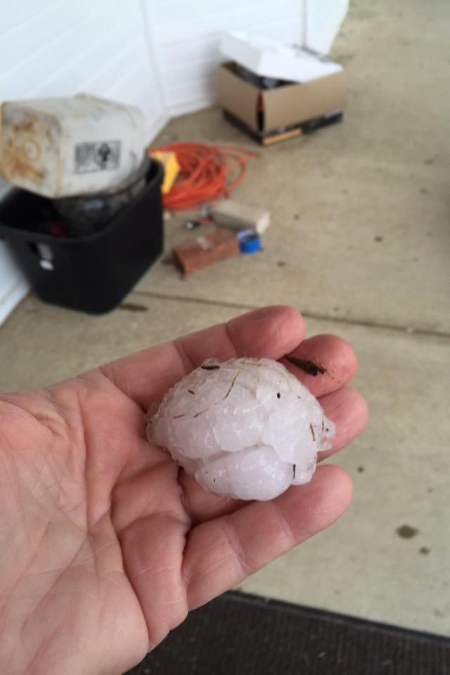
The sky turned a strange shade of red around New Orleans Wednesday evening as a tornado-warned storm pushed through, dumping heavy rain and hail in the area.At 5:53 p.m., radar detected a possible tornado, setting off a warning for parts of St. Bernard and Orleans parishes. Though there was no visual confirmation that the storm actually produced a tornado, large hail was reported across the area. The New Orleans Advocate reported. The city's Office of Emergency Management said the northern half of Kenner sustained minor damage. There were reports of downed power lines and trees, as well as street flooding.

Link:http://www.weather.com/news/news/new-orleans-louisiana-hail-storm


View image on Twitter

Tuesday, March 31, 2015

Record Heat Coming Up in the West of 100 Degrees

The hottest weather so far this year has arrived in the West and will continue through early this week in the Southwest. Last Thursday brought the year's first triple-digit temperature reading anywhere in the country when Death Valley, California, logged an official high of 101 degrees. Death Valley topped out a degree higher at 102 degrees on both Saturday and Sunday. On Monday, the high was 103 degrees, which ties the all-time record high there for the month of March. In Arizona, Phoenix clocked its fourth consecutive day in a row with high temperatures above 95 degrees on Monday. This is the earliest that this has happened there since records began in 1895.
A ridge of high pressure is responsible for the record warm temperatures that we have seen in the West. While generally above-average temperatures will persist in the Southwest early this week, a Pacific cold front and an attendant southward dip in the jet stream should knock temperatures back at least to seasonal averages in the Northwest, northern Rockies and northern Great Basin by Tuesday.
Link:http://www.weather.com/forecast/national/news/record-warm-march-west


Forecast Highs Next Three Days

Spring Temperatures Return to the Midwest

After months of brutal cold, and weeks of teasing temperature roller coasters, a welcomed spring warm up is developing in the Midwest and the Northeast this week.As the week continues, the jet stream will lift northward in the central and eastern states, allowing some warmer air to spread from the Plains into the rest of the Midwest and Northeast.
According to the latest April temperature forecast from Weather Services International (WSI), there are signs that milder temperatures may dominate overall in the Midwest and Plains for the rest of the month, while the Northeast may not be so lucky. Below is a look at what you can expect from the warm up this week, plus April's temperature forecast for the Lower 48 states.
Initially, the Midwest will see the benefits of this pattern change with a northward bulge in the jet stream spreading eastward from out of the West. As a result, warmer-than-average temperatures will engulf the Midwest from west-to-east through Thursday. Thunderstorms, possibly severe, may also accompany the warmer temperatures by midweek. Daytime highs will be as much as 25 degrees warmer than average, particularly in the Plains and Upper Midwest through Wednesday. Highs will soar into the 60s, 70s and 80s at times early in the week across the Midwest.
Link:http://www.weather.com/forecast/national/news/spring-temperatures-return-welcome-warm-up-for-midwest-northeast

Midwest Forecast

Large Hail in Arkansas Mid-Monday

Severe weather is underway in the Mid-South, dumping large hail on parts of Arkansas Monday afternoon.Hail the size of golf balls and slightly larger was reported by storm spotters in towns near Little Rock on Monday. There were no immediate reports of damage or injuries from the storms.

"Weak disturbances are moving across the South, where sufficient moisture is in place for the development of thunderstorms capable of producing large hail and localized damaging wind gusts," said weather.com meteorologist Chris Dolce. "This threat through Tuesday evening will be along a west-to-east swath from southern Oklahoma and northern Texas to Georgia. Additional severe storms are possible in parts of the Plains, Midwest and South through Friday."

Link:http://www.weather.com/storms/severe/news/severe-weather-midsouth-southeast

View image on Twitter

Super Typhoon Maysak Threatens The Philippines

Super Typhoon Maysak has rapidly intensified since Monday and is the equivalent of a Category 5 hurricane, according to the Wednesday morning advisory issued by the National Weather Service in Guam (Guam is 14 hours ahead of U.S. Eastern daylight time).
Maysak now packs estimated maximum sustained winds of 160 mph, becoming only the third super typhoon in reliable records dating to the 1940s with estimated winds that strong prior to April 1, according to Weather Underground's Dr. Jeff Masters.
Maysak is also only the fifth super typhoon of record prior to April 1, according to senior digital meteorologist, Nick Wiltgen. A western Pacific tropical cyclone is named a "super typhoon" when maximum sustained winds reach 150 mph. The last such pre-April super typhoon was Super Typhoon Mitag in March 2002.

The eye of Maysak was moving westward to the north of Yap Island (population ~ 11,000) as of early Wednesday morning, local time. This should keep the most violent winds from Maysak just to north of Yap. That said, typhoon-force winds up to 75 mph are possible in the Yap Islands as Maysak makes its closest approach Wednesday morning. Coastal inundation of 4-6 feet is possible along windward shorelines of the Yap Islands. Rainfall flooding is also likely in poor-drainage and low-lying areas.

Link:http://www.weather.com/storms/typhoon/news/typhoon-maysak-yap-philippines-pacific

Infrared Satellite: Maysak

Tuesday, March 17, 2015

Northeast Can See Snow as Spring Arrives

Spring, the vernal equinox, officially arrives at 6:45 p.m. EDT Friday. In the wake of yet another snowmaker for Downeast Maine and parts of Atlantic Canada Tuesday, fresh, cold air will be dragged into the Northeast. Before you become concerned that this sounds like another big Northeast snowstorm, there are several aspects that mitigate this threat:
- The cold air becomes more "stale" by Friday, thus near-surface temperatures may allow for some melting of falling snow.
- It's also late March. With the sun higher in the sky, that would also add several degrees of warmth to an air mass compared to what we would see in January or February.
- The offshore low-pressure system isn't expected to become strong. Therefore, strong winds will not be an issue.
- This system is expected to exit quickly by Saturday. Therefore, this will limit the potential for heavy precipitation.

While Boston's seasonal snow record has been well documented, there are also a couple of snow cover longevity notables from this winter that you may not have heard about:
- Newark, New Jersey: Record 45 straight days with at least 1 inch snow cover (ended March 9).
Syracuse, New York: Record 19 straight days with over 2 feet of snow cover (ended March 9).
Machias, Maine: Set daily snow depth records from Jan. 28-March 11, then again on March 16 (40 inches).

Link:http://www.weather.com/storms/winter/news/northeast-snow-forecast-spring-equinox

Cold Air Returns for St. Patricks Day

Everyone was overjoyed with the weather on Monday, March 16th. Chicago reached the degrees of 70 and everyone made sure to take a walk. The problem is that everyone is getting use to this weather but now for St. Patrick's day it went back down to 40 degrees. A cold front pushed south of the Canadian border on Monday. From there, it will slice through the East Coast and into parts of the South on St. Patrick's Day. Behind this cold front, temperatures will be 20-40 degrees colder than Monday. That said, temperatures in the Midwest will only fall back to levels more typical of mid-March.

Since last week, however, most of the U.S. has been under the influence of air masses that originate from either the Pacific Ocean – in some cases, the tropical Pacific – or the Gulf of Mexico. Naturally, this has combined with March's higher sun angle and longer days to bring a big warm up to much of the country. According to The Weather Channel storm specialist Dr. Greg Postel, part of the reason for this pattern shift has been a large cluster of thunderstorms, including several tropical cyclones, thousands of miles away over the southwestern Pacific Ocean.

Link:http://www.weather.com/forecast/national/news/colder-weather-pattern-change-spring-equinox-2015

Tuesday

Wednesday, March 4, 2015

Chile's Villarrica Volcano Erupts; 3,500 People Evacuated

Early Tuesday morning, authorities evacuated thousands in southern Chile after volcano Villarrica erupted around 3 a.m. local time. The volcano created a fiery spectacle as streams of lava poured down the mountainside and heavy smoke belched in the air.

Villarrica, one of South America’s most active volcanoes, prompted the National Emergency Office to issue a red alert and order the early morning evacuations. Photos from local media surfaced, displaying captivating images of the monster mountain glowing in the darkness, lava streaming and heavy smoke clouding the air. No injuries have been reported, however authorities are worried melting snow may trigger mudslides and endanger nearby communities.

The small city of Pucon, population about 22,000 people, sits in the shadow of the 9,000-foot volcano in Chile’s central valley. The area is 400 miles south of Santiago. Tourists flock to the area around Villarrica for outdoor activities like kayaking, horseback riding, fishing and hiking around the volcano, which last had a major eruption in 1984. Dozens of tourists were among those evacuated. Officials said late Tuesday that about 15,000 people living in rural areas near the volcano were suffering water shortages after the eruption and kept the red alert for nearby areas.

Link:http://www.weather.com/news/news/chile-villarrica-volcano-erupts

30 years of above average temperatures means the climate has changed

If you’re younger than 30, you’ve never experienced a month in which the average surface temperature of the Earth was below average. Each month, the US National Climatic Data Center calculates Earth’s average surface temperature using temperature measurements that cover the Earth’s surface. Then, another average is calculated for each month of the year for the twentieth century, 1901-2000. For each month, this gives one number representative of the entire century. Subtract this overall 1900s monthly average – which for February is 53.9F (12.1C) – from each individual month’s temperature and you’ve got the anomaly: that is, the difference from the average.
The last month that was at or below that 1900s average was February 1985. Ronald Reagan had just started his second presidential term and Foreigner had the number one single with “I want to know what love is.”These temperature observations make it clear the new normal will be systematically rising temperatures, not the stability of the last 100 years. The traditional definition of climate is the 30-year average of weather. The fact that – once the official records are in for February 2015 – it will have been 30 years since a month was below average is an important measure that the climate has changed.
Link:http://www.wunderground.com/blog/RickyRood/comment.html?entrynum=329#commenttop


Tuesday, February 24, 2015

Forecast for Snow in the South

Low pressure is expected to track from near the Gulf Coast to off the Southeast coast in response to an energetic upper-level system kicking out of the Southwest. With sufficiently cold air in place, the low will help pull moisture northward across the South, resulting in snow for some locations, and a cold rain for others.
Wintry precipitation becomes more widespread and expands eastward through the day. In general, snow or a rain and snow mixture is possible between I-20 and I-40 from northeast Texas, southern Arkansas and northern Louisiana to northern Mississippi, northern Alabama, northern Georgia, far southern Tennessee, Upstate South Carolina and eventually North Carolina. Poor travel conditions are likely in this swath.
Below is an overview of the forecast for Winter Storm Remus, which starts Tuesday night and goes through Wednesday night. However, keep in mind that this forecast will likely change leading up to the event, so check back for updates.
Link:http://www.weather.com/storms/winter/news/winter-storm-remus-south-snow

Tuesday's Night Forecast

Monday, February 23, 2015

Photographer Moves Halfway Around the World to Chase Storms

Oliver Kay left one of his jobs to become a photographer and chasing storms.. He take some really good pictures that have been became popular. Talk about a change of heart. Oliver Kay left his dead-end IT job in Manchester, United Kingdom, to chase storms in Australia nearly a decade ago.
During the week, Kay works at one of Perth’s largest mining companies. He saves the weekends for his true love: storm photography.

“I’ve always had a passion for landscape photography and spend most of the weekends trying to capture the stunning Australian scenery,” Kay told The Mirror. “The only problem with great scenery is that there are thousands of people getting the same shots over and over again of the same locations. With storms, there are never two photos the same.”Thunderstorms are most common in Perth throughout the winter; in Australia, the wintertime has weather equivalent to summertime in the United States. According to the Australian Bureau of Meteorology, severe thunderstorms are responsible for more damage than tropical cyclones, earthquakes, floods or brushfires.
Kay has his work cut out for him in Perth. “Lightning will never create the same patterns from one bolt to the next,” the photographer said, “and clouds are always different in shape, size and color, which adds so much drama to any landscape.”

Link:http://www.weather.com/science/news/photographer-moves-halfway-around-the-world-to-chase-storms

Monday, February 16, 2015

Hurricanes Destroying Baby Names

Depending on where you're from and what generation you grew up in, it might be hard to imagine anyone naming a newborn child after one of these famous hurricanes that caused so much destruction and human loss. NOAA's National Hurricane Center has been giving human names to hurricanes since 1953, and the Social Security Administration has been keeping track of the names given to newborn humans in the U.S. since 1880.

Of those 35 tropical cyclone names we researched, 10 are no longer popular and had fallen out of favor long before their namesake hurricane struck. For example, Sandy last appeared in the top 1,000 baby names for girls in 2005, seven years before Super Storm Sandy slammed the Northeast. Other household-name powerhouse storms including Bob (1991), Opal (1995), and Rita and Wilma (2005) fall into that category.

This can really affect a parent's decision to name their child. Hurricane Katrina being one of the biggest hurricanes ever to occur. People would definitely think twice before naming their child this. It is crazy to see how a storm can have such an effect on the world especially children's names.

Link:http://www.weather.com/storms/hurricane/news/baby-names-hurricanes-popularity-20141022#/1

Winter Storm Octavia Creating Havoc in the South and Mid-Atlantic

Octavia has already blanketed parts of a swath from Missouri to Virginia with more than 6 inches of snow. As of 8:30 p.m. on Monday, the top reported snowfall total was 17 inches near Coleman in far eastern Kentucky.A mix of sleet and freezing rain has already slickened roads and triggered power outages in Arkansas, Mississippi, Tennessee, Georgia and the Carolinas. For the latest snow and ice totals. Octavia has begun to extend its snowy and icy tentacles across the Appalachians and into parts of the Mid-Atlantic and Northeast – and its path may possibly include New England yet again.Snow, sleet and freezing rain will make travel difficult, and winter storm warnings are still in effect for some 33 million people, down from 46 million earlier Monday.

People in the Southern states are probably not use to receiving a winter storm watch for their area. Mid-Atlantic has seen up to six inches of snow. Significant ice amounts will occur in Northern Georgia and some parts of South Carolina. It is amazing to see weather this bad in mid-February.

Link:http://www.weather.com/storms/winter/news/winter-storm-octavia-snow-ice-south-plains-northeast-early-week

Forecast Rain and Snow

Tuesday, February 10, 2015

Winter Storm Marcus Makes Daily Tasks Impossible in Boston

After nearly 6 feet of snow in 17 days, transportation infrastructure in parts of New England have reached a breaking point, particularly in Massachusetts, where the governor declared a state of emergency. The Massachusetts Bay Transportation Authority (MBTA) has suspended all rail service through Tuesday, saying the snow was making it "virtually impossible" to keep its trolleys, commuter trains or subway lines safely running. Buses will continue on a limited schedule.

Winter Storm Marcus has created impossible for people to travel and get where they need to be on a daily basis. As a busy person, you do not understand how much snow can really effect a person's travel day to day. This can ruin a person's day or their commute to work. Also, let's say that a huge snowstorm came through like Marcus, but then all of a sudden a warm temperature hit. This would then cause uncontrollable flooding. Snow can be very dangerous as well.

Link:http://www.weather.com/storms/winter/news/winter-storm-marcus-new-England

Monday, February 9, 2015

Snowstorm Linus Turns Old Abandoned Mall into Winter Wonderland

Linus dropped 5 inches of snow, letting nature take over at the Rolling Acres Mall, which has been left decaying and exposed to the elements since 2008. The storm caused a skylight at the mall to break, blanketing the interiors of the once-bustling shopping center in snow.

When Linus hit the Midwest and the Northeast, Many inches of snow cause major damage and issues with transportation. It seems though that another place was damaged too. In Ohio, an abandoned mall was filled with snow. The pictures of this mall is actually pretty intriguing. It looks like a fun place to go and play in whether you are a child or adult.


Link:http://www.weather.com/travel/news/seph-lawless-mall-snow

Tuesday, February 3, 2015

Second Half of January Brings Record Warm Tempatures

The second half of January created a warm air mass around mostly the west region. The most remarkable record happened in a place famous for recording the world's official record high temperature back in July 1913. Death Valley, California, reached 87 degrees on Sunday, Jan. 25, tying its all-time record high for the month of January. States like Kansas, Nebraska, and South Dakota all reached all time high in their temperatures for this January.

So why did this weather shift happen in the end of January? As usual, a sharp northward bulge in the upper-atmospheric jet stream – known technically as a "ridge" – played a role in the pattern. The first northward bulge last week sent the jet stream as far north as the Yukon in northwest Canada, bringing a rush of mild Pacific air into western Canada, then east across the Rockies.A second bulge in the jet stream arrived on the West Coast over the weekend, bringing an even warmer air mass into the western U.S. and setting the stage for the widespread record warmth in recent days.

Link:http://www.weather.com/forecast/national/news/mild-midwest-warm-west-record-highs

Monday, February 2, 2015

Winter Storm Linus: Top Five Snowstorm of all time in Chicago and Detroit

Winter Storm Linus has been recorded as one of the top five snowstorms to hit the Midwest. The storm left about 10 inches in and around areas from Kansas to Michigan. Linus left about 20 inches in Kalamazoo, Michigan. Illinois and Iowa had a recorded 10 to 12 inches making it a record setting snowstorm. This caused about 90 million people to be affected by this storm. Major power outages were also caused by heavy snow on the power lines.

Living in Chicago, I experienced this snowstorm firsthand. It was really dangerous when it came to icy conditions and terrible road conditions. Many cars were put off the road due to snow or ice. People should definitely think twice before driving with these conditions.

Link:http://www.weather.com/storms/winter/news/winter-storm-linus-forecast-plains-midwest-northeast