Showing posts with label Paulina Kotwica. Show all posts

Tuesday, April 28, 2015

Met Office predicts another severe storm for Pakistan


http://tribune.com.pk/story/877059/brace-for-another-storm-next-week-met-office/
In a press conference held here on Monday at PMD, Mohammad Aleem ul Hassan, deputy director forecasting, PMD said two more weather systems are expected to approach upper parts of the country over the next ten days.
Therefore scattered rain with dust-storm is expected in upper parts of K-P which include Peshawar, Malakand, Mardan and Hazara Divisions and in North Punjab which includes Islamabad, Rawalpindi and Sargodha division and Kashmir in the next 10 days, he said.
“Though it is impossible to predict a storm but considering the recent windstorm in Peshawar that has claimed over 40 lives the Met office is expecting another one in coming days,” he said.
"He said for Peshawar rain and thunderstorms were predicted two days before the day it occurred by PMD. “There is no truth in this news that PMD did not issue any early warning to the K-P government for the windstorm so that precautionary measures could have been taken to save many precious lives,” said Hassan.
He said such types of extreme weather events rarely develop due to thermal contrast during March and April which is a transitional period when days are getting hot and nights are still cold.
“Such interaction of cold air coming from west and warm air from east or south results in windstorm,” he explained.
The opinion was echoed by Sher Ali Khan, spokesperson Aviation Division who speaking at an event said it was very unusual extreme weather event that rarely occurs in Pakistan. However in the past similar kinds of windstorms had occurred in March 2001 and March 2011, respectively
He said the occurrence of such extreme weather conditions is the result of massive deforestation, urbanisation and pollution.

Climate Change


http://www.newscientist.com/article/dn27426-three-in-every-four-extremely-hot-days-linked-to-climate-change.html#.VT--UFyefzI
If climate change was a game, we'd have racked up quite a score. A fresh study suggests that humans are responsible for a hefty number of today's extreme hot days and rainstorms.
Weather extremes, such as a Russian heatwave in 2010 and a drought in Texas in 2011, have been blamed on climate change before – but the attribution of individual events to it is still hotly debated.
So Erich Fischer and Reto Knutti at the Institute for Atmospheric and Climate Science in Zurich, Switzerland, took a bird's-eye view of how human activity is changing the planet. Using 25 different climate models, they calculated how the odds of unusual events – such as a 1-in-100 day temperature high or a 1-in-10,000 day rainfall event – have changed with the rise in global temperatures.
Their results show that global warming of 0.85 °C since the industrial revolution has had a powerful effect. Climate change is now responsible for 75 per cent of our extreme highs in temperature and 18 per cent of extreme rainfall, according to the data. The rarer a particular event, the more likely that warming is the cause, they say.
"A 1-in-10,000 day heat event is something that's only expected to happen every 30 years. But in a global-warming world, it's turned into a 4-in-10,000 day event. Three of those hot days – or 75 per cent – would never have happened if global warming wasn't around," says Fischer.

Marine life at risk due water temperatures


http://www.cnn.com/2015/04/22/us/pacific-ocean-blob/
(CNN)Marine life seen swimming in unusual places. Water temperatures warmer than they should be. No snow where there should be feet of it. 
Some scientists are saying "The Blob" could be playing a factor.
As monikers go, the blob doesn't sound very worrisome.
But if you're a salmon fisherman in Washington or a California resident hoping to see the end of the drought, the blob could become an enemy of top concern.
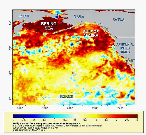
A University of Washington climate scientist and his associates have been studying the blob -- a huge area of unusually warm water in the Pacific -- for months. 
"In the fall of 2013 and early 2014 we started to notice a big, almost circular mass of water that just didn't cool off as much as it usually did, so by spring of 2014 it was warmer than we had ever seen it for that time of year," said Nick Bond, who works at the Joint Institute for the Study of the Atmosphere and Ocean in Seattle, Washington.
    Bond, who gave the blob its name, said it was 1,000 miles long, 1,000 miles wide and 100 yards deep in 2014 -- and it has grown this year. 
    And it's not the only one; there are two others that emerged in 2014, Nate Mantua of the Southwest Fisheries Science Center -- part of the National Oceanic and Atmospheric Administration (NOAA) -- said in September. One is in the Bering Sea and the other is off the coast of Southern California. 
    Waters in the blob have been warmer by about 5.5 degrees, a significant rise.

    Scientists pinpoint Strange Blob as reason to unusual weather

    http://www.techtimes.com/articles/45388/20150411/scientists-pinpoint-strange-blob-of-warm-water-as-culprit-behind-weird-weather.htm
    The weather has been weird, and scientists have found that a strange "blob" of warm water is to be blamed. Located off the West Coast, this patch of water is warmer by 2 to 7 degrees Fahrenheit than normal.
    Nick Bond, a climate scientist for the Joint Institute for the Study of the Atmosphere and Ocean, said that scientists started noticing the blob between the fall of 2013 and the early months of 2014. After doing some observations, scientists realized that the mass of water wasn't cooling off as it usually did. When spring of 2014 rolled in, the blob even became warmer - the hottest ever recorded for that area in that time of year.
    Bond officially called the water mass "the blob" last June 2014 in a monthly newsletter released in his capacity as state climatologist of Washington. The blob was described as stretching 1,000 miles in every direction and going as deep as 300 feet.
    By April this year, the blob has been located off Washington's shores, squished against the coast while extending 1,000 miles offshore between Mexico and Alaska. According to Bond, weather models are indicating that the blob will continue until at least the end of 2015.

    Autumn Snowfall

    http://www.9news.com.au/national/2015/04/08/10/33/unusual-autumn-snowfall-in-nsw-signals-abrupt-start-to-winter
    Only a month into autumn, snow is falling in parts of the country with a town in NSW experiencing their earliest snowfall in seven years.
    The abrupt weather surprised residents in Oberon, a small town near the Blue Mountains, after a low pressure system off the coast and cold air in the upper atmosphere produced the smattering, barely weeks into April.
    Althought not unprecedented, the frosty conditions are unseasonably early.
    “It is unusual. Normally around May or June is when the first snowfall is,” Bureau of Meteorology spokesman David Barlow said.
    “It is still going to be cool in the next few days, but it will be warming up as we head into the next week.”
    Victorians are also feeling the snap, with severe weather warnings in place this morning for heavy winds and rainfall.

    Severe Weather pummels through Baton Rouge


    http://www.lsureveille.com/daily/severe-weather-pummels-through-baton-rouge-lsu-classes-canceled/article_43cf5118-ed00-11e4-8f96-d326c0160389.html
    In a week often plagued by pre-finals gloom, University students received a windy Monday morning wake-up when severe weather barreled through Baton Rouge.
    The National Weather Service issued a tornado warning for East Baton Rouge Parish on Monday morning until 10 a.m. The University canceled classes for the rest of the day soon after.
    Facility Services Assistant Director Tammy Millican said Facility Services crews are responding to a series of work orders placed by faculty, staff and students located throughout campus regarding leaks and flooding in buildings, as well as assessing the storm’s damage.
    “The issue is that when rain comes that hard and that fast, you are going to have that type of issue, so that’s not something that’s unexpected, so we’re just responding to that and getting that water out of the building and protecting the contents of the building,” Millican said.

    Besides a power outage at a University warehouse on River Road, Millican said she was not aware of any other campus power outages.

    Severe Weather Shifts to Houston

    http://www.accuweather.com/en/weather-news/severe-weather-shifts-to-houst/46228809
    Severe weather will shift to the western Gulf Coast on Monday, becoming replaced by a chilly rain and wind in the southern Plains.
    While these cities will turn cooler to start the new week, the severe weather threat zone will center on Houston and College Station, Texas and Lake Charles, Baton Rouge and New Orleans, Louisiana.
    "Monday will bring a one-two punch of strong storms to southeastern Texas and Louisiana," stated AccuWeather.com Meteorologist Becky Elliott.
    "A squall line looks to move through [southeastern Texas and western Louisiana] in the morning hours and could produce damaging winds and torrential downpours," she continued.
    In addition to the potential for some tree damage and power outages, those in Houston will be faced with a slower commute with possible delays to both air and ground travel.

    State of Emergency In Parts of Louisiana

    http://www.weather.com/storms/severe/news/louisiana-severe-weather-flooding
    Louisiana Gov. Bobby Jindal declared a state of emergency in a handful of parishes after strong storms brought on flooding, and also left thousands of people without power.
    Gov. Jindal said Assumption and Lafourche parishes have declared emergencies to help open response for storm cleanup; more counties could be brought under the declaration.
    The rain started early in the day, knocking out power to as many as 200,000 homes and businesses at the height of the storm, according to The Associated Press.
    Local storm reports showed winds gusting as high as 71 mph at Louis Armstrong New Orleans International Airport as the storms passed through, just before 10:30 a.m. local time.
    Around the same time is when six to eight freight containers fell off the Huey P. Long Bridge outside New Orleans. A WGNO TV crew recorded it as it happened. No one was hurt and the containers weren't carrying anything hazardous.
    A tornado was reported by spotters in the Belle Chasse area, local storm reports said.
    The National Weather Service said New Orleans saw 1.74 inches of rain, setting a new record for April 27.
    Earlier in the morning, the westbound lanes of Interstate 10 were closed at Exit 127 due to a fallen tree brought down by the wind, according to the Department of Transportation.

    Severe Weather hits Texas


    http://www.weather.com/news/news/texas-severe-storm-photos
    Severe weather hit parts of Texas Sunday night and Monday morning, producing baseball-sized hail, damaging wind gusts and reported tornadoes. 
    One tornado was confirmed Sunday afternoon in the area of rural Comanche and Erath counties in Texas. No injuries were reported in the immediate aftermath of the tornado. 
    Tornadoes have also been spotted southeast of Stephenville, and in Glen Rose and Cleburne State Park on Sunday evening, according to WFAA.com. Overnight, a large tornado left damage in the Rio Vista area.
    Baseball-sized hail was reported near Stephenville, about 70 miles southwest of Fort Worth, and motorists were reporting damage to vehicles, according to the Associated Press. National Weather Service meteorologists also received reports of shingles being blown from rooftops, according to the Fort Worth Star-Telegram.
    Stephenville police say shelters have opened at the city library and other locations. Many of the storms moved slowly, and the torrential rains led to serious flooding in several areas, including Rio Vista.
    We are collecting the most dramatic images from this severe weather event, and you can view them in the gallery at the top of this page. Please check back frequently for updates.

    Late-season cyclone forming

    http://www.abc.net.au/local/photos/2015/04/28/4225490.htm
    As temperatures drop across the North West, tourists are rolling into towns and thoughts are turning to the dry season ahead. But Neil Bennett, the Bureau's manager of media and communications, is urging all in the region to be aware that the cyclone season is not over.
    "We still technically are in the cyclone season. The cyclone season runs from November to April, but really Mother Nature doesn't take too much notice of the constraints that humans put on the calendar," he said.
    Forecasters' attention has been caught by a tropical low south of Indonesia, which is making the most of the last of the warm ocean temperatures.
    "We are expecting that as it continues to track southwards, it will start to intensify, and it's highly likely that we will see a tropical cyclone," Mr Bennett said.
    If the system develops as forecast, a category two cyclone will see in the first day of May.

    Pakistan Severe weather tolls to 45 dead


    Officials say the death toll from severe weather in northwestern Pakistan has risen to 45.
    Mushtaq Ghani, the information minister for Khyber Pakhtunkhwa province, provided the latest toll Monday, saying several hundred people had been hospitalized.
    The storm late Sunday brought heavy rains and winds of up to 120 kph (75 mph), causing hundreds of homes to collapse, uprooting trees and downing electric poles. Meteorological official Mohammad Hanif says the unusual storm caused tornadoes.
    Ghani says thousands of people have been left homeless and crops have been washed away.
    Pakistani army and civilian agencies have launched rescue and relief operations in the region.

    Tuesday, April 21, 2015

    Asperatus Clouds Form


    Asperatus Undulatus: The Wavy Canopy

    The choatic, wavy canopy of clouds is known as asperatus undulatus, Latin for "agitated waves."
    This cloud species, not yet officially recognized by the World Meteorological Organization, is sometimes seen after a thunderstorm's gust front has passed you. 
    Ahead of either a single thunderstorm or line of storms, you may first experience a strong gust of wind, which denotes the gust front.  Look skyward – from a safe place in a thunderstorm, that is – and you may see these undulatus asperatus clouds. 
    Similar to lenticular clouds, what you're seeing is turbulent wave motion. According to Graeme Anderson, from the Department of Meteorology at Reading University, winds at cloud level lead to sufficient wind shear to produce the wavy motion.
    This wavelike motion akin to flapping one end of a blanket or bed sheet up and down can be seen most demonstrably in a timelapse of undulatus asperatus, such as what was captured by the National Weather Service in Columbia, South Carolina, on Monday morning.

    Warming of the Pacific coast

    http://www.newscientist.com/article/dn27362-mystery-blob-in-the-pacific-messes-up-us-weather-and-ecosystems.html#.VTan11yefzI

    An unusual threat is looming off the Pacific coast of North America from Juneau in Alaska to Baja California. Now roughly 2000 kilometres wide and 100 metres deep, a mass of warm water that scientists are calling "the blob" has lingered off the coast for a year and a half and has set temperature records, with waters between 1 °C and 4 °C warmer than normal.
    Fresh research published in Geophysical Research Letters has examined the causes and impacts of this area of water, which has grown more recently.
    The blob has changed water-circulation patterns, affected inland weather and reshuffled ecosystems at sea. Although scientists say the planet's warming oceans may not be responsible for the mysterious and long-lived anomaly, some see it as an early warning of changes that might be coming to the Pacific in the next few decades.
    Satellite imagery first alerted scientists to the strange formation in August 2013, when the roundish blob was seen over the Gulf of Alaska. Researchers think that a long-lasting weather pattern called a high-pressure "ridge" deflected winds that stir up cool waters from the deep and bring cool air and water from high latitudes.

    Friday, April 3, 2015

    Rare eclipse spoiled by rain on Easter


    Easter is just around the corner - and so is the only total lunar eclipse for the year that can be seen right across Australia, if rain doesn't spoil the parade.
    This eclipse will be the shortest in at least a century -- if not longer, says Andrew Smith an astronomer at Sydney Observatory.
    Total lunar eclipses occur when the Earth passes between the Sun and the Moon casting a shadow on the face of the Moon. 
    This one will be super-short because the moon is just scooting the inside edge of the Earth's shadow, says Smith.
    "Imagine one small circle crossing in front of a larger circle -- instead of going across the middle, which would take the longest, it's just going across the inside edge. That's the shortest distance it can travel through that shadow," he explains.
    And, as it's not going deep into the Earth's shadow, it may not appear deep red during totality but take on a two-tone effect.
    "What's most likely is the side of the moon that's furthest into the shadow will be a deeper red and the edge of the moon that's only just in the shadow might be a brownish-grey."
    Its appearance will also be affected by factors such as pollution and dust in the air.
    "What creates that reddish light is all the light from all the sunsets and sunrises on earth, that's the only light that reaches the Moon during a total eclipse," says Smith.

    Friday, March 27, 2015

    Do they still call it Antarctica if its warm?

    http://mashable.com/2015/03/27/antarctica-all-time-high-temperature-record/
    Antarctica, Earth's coldest, most barren continent, may have just set a remarkably unusual weather record. An Argentinian research station on the rapidly warming Antarctic Peninsula recorded a high temperature of 63.5 degrees Fahrenheit (17.5 degrees Celsius) on March 24, according to reports from Weather Underground. 
    If this is investigated and verified by the World Meteorological Organization (WMO), it could become the highest temperature on record for the entire continent of Antarctica.
    The warmth at the Esperanza research station came one day after a nearly identical high temperature was logged at another Argentinean base, known as Base Marambio, also located along the Antarctic Peninsula. Interestingly, the mild conditions occurred during the Antarctic fall, not the height of summer.
    More broadly, the Antarctic ice sheet is proving to be far more dynamic than scientists thought was the case just two decades ago. A study published on Thursday, for example, found that the loss rate of Antarctic ice shelves, which play a crucial roll in buttressing inland glaciers and preventing them from sliding quickly into the sea, has accelerated by 70% in just the past decade. 
    This may mean that climate scientists will need to raise their global sea level rise projections. Such projections also take into account ice loss from the Greenland ice sheet, where temperatures are also increasing rapidly.

    Southern California Turns White?

    Beaches and streets in Southern California suddenly turned white during a hailstorm late Monday morning, stunning residents who quickly ran outside to get a picture or play in the unusual weather.
    Enlarge
      The hail was reported in areas like Huntington Beach and Long Beach – areas that have seen little precipitation of any kind in recent months due to a long-term drought that has gripped the West.
      "Upper-level energy associated with Winter Storm Thor has been triggering thunderstorms along the California coast since this past weekend," said weather.com meteorologist Chris Dolce. "These thunderstorms produced small hail that whitened the ground in parts of the Bay Area on Saturday and did the same in Southern California on Monday."
      Winter Storm Thor is expected to move from the West Coast through the Plains and East, affecting parts of 48 states on the way.
      Check out more of the most awesome images from the Southern California hailstorm below.

      Unusual Weather Accelerates Summer Crop Season

      Californian growers are gearing up for another early season of their summer crops following record high temperatures in parts of the state. apricot_69882310 thirdsq
      California Fresh Fruit Association (CFFA) president Barry Bedwell said the industry may be roughly two to three days ahead of last season, which was early in itself.
      The high temperatures began around Friday (March 13) last week, when a high pressure system built up over parts of the state.
      “I think that once again we’re experiencing an early season, and this heat certainly confirms and accelerates that,” he told www.freshfruitportal.com.
      “Having said that, this weather is highly unusual and once again continues to set records. That 91°F (33°C) I think we had in this area [Fresno] on Sunday was an all-time record for the date by four degrees, and one of the hottest temperatures we have seen in the month of March ever.”
      http://www.freshfruitportal.com/2015/03/18/california-highly-unusual-weather-to-accelerate-summer-crop-season/?country=united%20states

      Weather Causes Unusual Amount of Arctic Ice


      http://www.trinitynewsdaily.com/arctic-sea-ice-may-reach-all-time-minimum-low/1158/

      ANCHORAGE – 
      Satellites that take pictures of ice in the Arctic are showing the lowest amount of sea ice ever recorded, according to scientists at the National Snow and Ice Data Center in Colorado.

      “The middle part of the country and the east coast were getting a lot of the cold winter weather, whereas here in Alaska, we were getting more of the warmer weather,” Schreck explained. “There was warm air coming into the state that we don’t usually see.”
      But Schreck said the ice closest to Alaska in the Bering Sea did not look significantly different from last year, with the exception that it may be thinner. She said it’s not unusual for the ice pack to change on an almost daily basis.
      “What happens with the ice — especially during the spring — is so reliant on weather patterns,” Shreck said. “The current weather patterns, not what has happened over the last few months. So it is normal for it to retreat and grow back and retreat and grow back throughout the spring time.”

      Shreck says it’s possible the ice pack in the Bering Sea is still growing, and may not reach it’s maximum extent for another week or so.

      Thursday, February 5, 2015

      Cloud-bursting service guarantees sunny wedding weather


      http://www.cnet.com/news/150000-cloud-bursting-service-guarantees-sunny-wedding-weather/
      Weddings can be expensive and fraught with stress as brides and grooms fret over every last detail, from the color of the cake icing to how to handle the weather if it decides to rain all over them and their 250 guests on the lawn of a dream chateau in the country. Oliver's Travels, a luxury holiday rental company, is offering to play weather god...for a price.
      For now only available in France, Oliver's Travel's cloud-bursting service sends out aircraft to trigger rain ahead of your wedding, hopefully leaving your special day clear of the wet stuff. The company says the package "can 100 percent guarantee fair weather and clear skies for your wedding day." The service requires three weeks of planning involving meteorologists and pilots skilled with using silver iodide to seed the clouds to prompt the rain.
      This type of cloud-bursting works by spreading silver iodide in clouds, causing moisture to condense around it, creating rain and encouraging the clouds to disperse.
      The cloud-bursting wedding guarantee only goes so far. Oliver's Travels notes that it can't do anything about major weather phenomenons like hurricanes. The service also has to take place 30 miles away from any domestic airports so that the cloud-seeding planes can operate at the correct altitude and not disrupt other air traffic.
      Hiring meteorologists, pilots and planes doesn't come cheap. The service starts at £100,000, which is about $150,000 or AU$200,000. At that price, the cloud-bursting is really more of a fun PR stunt than a practical addition to a typical wedding package. That might not stop some deep-pocketed people from throwing their money into the clouds in pursuit of fairytale wedding-day weather.

      Unusual Jet Stream to Blame for Weird Weather

      http://www.620ckrm.com/ckrm-on-air/ckrm-local-news/7533-unusual-jet-stream-to-blame-for-weird-weather

      Normally frigid Prairie cities are into their second week of a January thaw while easterners are digging out from an epic snowstorm, and climate scientists are blaming the jet stream.
      Environment Canada expert David Phillips says the high-altitude current of air that normally runs west-east has been looping all over the continent, bringing weather surprises in its wake.

      Some say the loopy jet stream is a side effect of climate change.
      Phillips says that theory shows promise, but more years and more data are needed before conclusions can be confirmed.