Showing posts with label Prince Ikerodah.. Show all posts

Tuesday, December 6, 2016

Winter 2016

Winter 2016 

Winter’s first major cold snap is blasting into the western United States on Monday. Through the rest of the week, temperatures will bottom out at 20 to 30 degrees below normal in the West. Most of the Lower 48 will experience the coldest weather of the season thus far by Sunday. The jet stream is pushing south this week, and as it does, it will allow cold air to spill in from Canada, and the Mountain West and Plains will endure the most biting chill. In Denver, temperatures are plummeting on Monday afternoon. After highs around 50 degrees, Denver’s temperature will fall into the teens Monday night. Tuesday night will be in the single digits, and Wednesday night will bottom out at subzero in the Mile High City. Parts of Montana — the Lower 48’s coldest locations — will be in the single digits through most of the week. In Cut Bank, Mont., the forecast low Tuesday night is a bone-chilling minus-11 degrees. When you factor in 20-mph wind gusts, the temperature will feel like minus-20 or minus-30. Northern California is also expecting a chill, although it won’t be nearly as intense as in the northern Rockies. Lows will drop to the 30s on Monday and Tuesday night in the San Francisco Bay area, except at locations near the coast where temperatures will be moderated by the warmer ocean water. Temps in the 30s may not seem that cold, but they will be as much as 10 degrees below normal for this time of year in Northern California.

https://www.washingtonpost.com/news/capital-weather-gang/wp/2016/12/05/the-coldest-air-of-the-season-so-far-is-spilling-into-the-lower-48-this-week/?utm_term=.3f24c78d24f8

Hottest Year

Hottest Year 

Nigeria
In the displacement camps of north-east Nigeria, most residents have the same answer for why 2.6 million people have been forced from their homes in this region. They are running from Boko Haram, the jihadist militants who still control significant parts of the Lake Chad basin.
But ask about how Boko Haram gained momentum in the first place, and a more complex narrative emerges. The extremists capitalised on high levels of local poverty, alienation and unemployment in north-east Nigeria. And that in turn, many local residents argue, was fuelled – in part – by the shrinking of Lake Chad, and the desertification of the surrounding area. With global temperatures soaring ever higher, it’s a trend unlikely to be reversed any time soon.
“It’s affected our livelihood, it’s affected farming and fishing,” says Mustapha Ali, a 50-year-old who grew up close to the lake’s former shores, and who is now living in a camp for internally displaced people. “We used to farm watermelon here, wheat, and rice – but because of the shrinkage of the lake, we can’t any more. Little by little it became harder and harder to [irrigate the] farm.”
Since the 1970s, global warming has caused the lake to shrink by around 90%. Once one of the world’s biggest lakes, at 25,000 sq km, it is now less than 2,500 sq km. Towns that Ali remembers reaching by boat can now be reached by car. At least one settlement has even been built on land that used to be underwater, Ali says.
For residents like Ali, the desperation caused by the shrinking of the lake was clearly a contributing factor to the rise of extremism.
“It’s helped the rise of Boko Haram,” Ali adds. “A lot of the youth there were unemployed, and when they have nothing to do, Boko Haram becomes an option. If you’re wealthy and you have things to do, you don’t want things like [Boko Haram] to happen.” Patrick Kingsley at Lake Chad

US

Advertisement
The Iditarod Trail Sled dog race is a fabled 1,000-mile-long trek through Alaska’s frozen wilderness, held annually since 1967. Unusually warm weather prompted a change in the starting location for last year’s race, while 7,000 gallons of snow was shipped in ahead of this year’s event in case of a lack of powder. The race, held in March, followed Alaska’s second warmest winter on record – the latest in a string of warm winters.
Chas St George, chief operations officer at the Iditarod trail committee, said: “You have ups and downs in terms of snow but this year and the year before were very mild in terms of weather and snowfall. Our creeks are flowing earlier and we are also getting more sun, which provides its own challenge for the people racing.
“Last year we staged the race out of Fairbanks because of a lack of snow, which is quite a distance further north. It’s cooler there, there’s more snow. We’ve only been forced to do that kind of thing in the last few years. There are times when these teams run on no snow at all. The question is whether you have enough snow at the start, until you get to the interior.
“This year for the ceremonial start, where people come out to watch the teams through Anchorage, we had to shorten the course from 11 miles to three miles. That was for safety reasons because there was only enough snow to get to a certain point. We haven’t had to shorten the course like that before.
“When it thaws and then freezes, all what’s left is ground that is still frozen, it’s very slick ice. It becomes a safety issue. People want to go as far as they can, that’s what they do this for, but they were very understanding. I’m sure the dogs were disappointed.
“We did have a contingency to get more snow in by rail this past year. It wasn’t needed though, we had enough snow, thank goodness. In parts of the course there was very little snow and then suddenly a huge amount of it hit.
“In Alaska there’s a ton of research that shows we are sort of at ground zero here [for climate change]. There’s been a clear warming trend. I don’t see significant changes to the race in the next couple of years but over the next 20 to 30 years we might have to look at it through a different lens. We may have to do things differently. But we want to keep this tradition going.” Oliver Milman in New York


https://www.theguardian.com/environment/2016/nov/14/it-was-too-hot-even-to-leave-home-stories-from-the-worlds-hottest-year

Why do meteors glow in vibrant colors?

Why do meteors glow in vibrant colors?

Meteor showers are one of nature’s most brilliant spectacles, each one bringing a unique experience for stargazers, including meteors glowing in a rainbow of colors.
Meteor showers occur several times a year when the Earth passes through a field of debris, such as particles from asteroids or grains of dust from a comet.
This debris burns up as it enters the Earth’s atmosphere, giving off a flash of light that some refer to as a shooting star. 
If seen out of the corner of your eye, a meteor may appear to give off a flash of white light, similar to the way stars appear. However, meteors can appear in a variety of colors if viewing conditions are clear or if they are captured in a photograph.
“The color of light that the meteors produce depends on their chemical composition,” AccuWeather Meteorologist Dave Samuhel said.
“Different chemicals in the meteors produce different colors as they burn up while entering the Earth’s atmosphere,” Samuhel said.
For example, meteors made from primarily calcium will give off a purple or violet color, while those made out of magnesium will appear to have a green or teal color. 
Meteor Shower Colors
What a meteor is made out of is not the only factor that determines the color that it appears. The speed at which the meteor enters the Earth’s atmosphere can also affect the color.
The faster a meteor moves, the more intense the color may appear, according to the American Meteorological Society (AMS).
“Among fainter objects, it seems to be reported that slow meteors are red or orange, while fast meteors frequently have a blue color,” the AMS said.
The Geminid Meteor Shower, one of the best meteor showers of the year, is a shower known for producing intensely colored meteors, Samuhel said. The Geminids peak in December.
The most common colors for this specific meteor shower are yellow, orange and sometimes green.
The Perseid Meteor Shower, another popular meteor shower that occurs every August, is also known for producing shooting stars that give off vivid colors.

http://www.accuweather.com/en/weather-news/why-do-meteors-glow-in-vibrant-colors/70000178

Weakening polar vortex may yield longer, harsher winters in North America

Weakening polar vortex may yield longer, harsher winters in North America

Longer, harsher winters may be in store for the portions of North America as the polar vortex continues to weaken and shifts, according to a new study.
The polar vortex is a large pocket of frigid air that hovers above the polar regions, and is most prominent in the winter months.
Researchers at China's Lanzhou University penned the study, which was published in Nature Climate Change last month.
Lanzhou researchers found that a loss of sea ice in the Arctic regions due to rising temperatures in the Barents-Kara seas, along with an increase in snow cover over Europe and Asia, has caused the polar vortex to weaken. The pocket of cold air has in turn shifted toward Eurasia.
This movement could lead to colder and possibly extended winter seasons for portions of North America and Eurasia, according to the study.
"With warming and ridging in the Kara Sea, this typically allows for less ice cover but also is a conducive atmospheric pattern for lower temperatures in the North American mid-latitudes," AccuWeather Meteorologist Edward Vallee said.
polar vortex weaker study
The polar vortex in winter can extend well into the atmosphere and at times be more than 100,000 feet deep, AccuWeather Senior Meteorologist Bob Smerbeck said.
A weaker polar vortex allows the stratosphere, or a distant part of the Earth's atmosphere, to warm, while a stronger one prevents that process, according to Vallee.
"The stratospheric vortex typically governs the tropospheric vortex [in the lower part of the Earth's atmosphere] during the winter months and is based on polar heating and cooling," Vallee said.
"As the stratosphere warms in winter, it can reverse the wind direction below it," he said.
This could block high pressure systems from taking shape in the high latitudes of the Earth, which would increase opportunities for cold in the mid-latitudes.
According to Smerbeck, the southern shift could bring the other end of the polar vortex toward eastern North America, yielding colder winters for the region.
"There are other factors that determine where the vortex sets up," Smerbeck said. "The warm blob over the north Pacific in winter 2013-2014 and the unusually warm waters along the west coast of North America [for the] 2014-2015 winter contributed to a southward dip in the vortex across eastern North America and cold winters in the central and eastern U.S."
Smerbeck said there is a lot of research still being conducted, and that while some researchers may not find the latest study overly convincing, a mechanical connection between the lack of sea ice and the vortex shift as opposed to just a statistical connection should allow for more accurate modeling.

Tuesday, November 29, 2016

Climate Change could be driving the Seabird to Starvation


Climate change could be driving the seabird to starvation, amid reports of mass puffin die-offs worldwide in recent years.

S.J. KRASEMANN/GETTY IMAGES
Two horned puffins perch on Alaska’s St. Paul island. Hundreds of puffins have washed up dead on the island’s rocky shores.
The puffins were not supposed to be there. Though the birds are a common sight on the Alaskan island of St. Paul, they typically fly the coop before October, heading south to overwinter.
But a few bedraggled birds had been discovered on the wind-swept, rocky shoreline of the North Pacific island during the first week of October. “It was odd because we don’t usually see them here this time of year,” said Aaron Lestenkof, who monitors the local environment as one of St. Paul’s island sentinels
Stranger still, the puffins didn’t startle and move away when people approached them. Some fell over onto their bellies, too weak to waddle.
Local conservationists began investigating the cause of the orange-beaked birds’ incapacity. Then their probe took a grim turn.
“By mid-October the dead ones started showing up,” Lestenkof told The Huffington Post over email last week.
“The first week collecting birds, I went out every day and was picking up a carcass every 15 feet in some areas.” 
Lestenkof had collected dozens of dead puffins within days, the lifelong resident of the island said.


“In past years, we would find about two or three dead puffins in a season, which was fairly common,” said Paul Melovidov, another sentinel who has spent weeks combing beaches for puffin carcasses and photographing the finds. “When you have 40 to 50 dead and fully intact puffins arrive on your shore within a week, it’s cause for alarm.”
At least 250 dead puffins have since been found on St. Paul, according to reports.
http://www.huffingtonpost.com/entry/dead-puffins-st-paul-alaska-climate-change_us_582ea97ce4b099512f823237 

Japan Tsunami Triggers Rare Tidal Waves

Japan Tsunami Triggers Rare Tidal Waves 

The strong earthquake and resulting tsunamin eastern Japan Monday did not result in significant damage or casualties, but it did produce an interesting and rare phenomenon known as a "tidal bore."

According to Andy Newman, an associate professor and geophysicist at Georgia Tech, "a tsunami acts much like a tide (hence the old name 'tidal wave'), which can contain significant tidal bore structures." Tsunamis used to be referred to as tidal waves, which is incorrect since they are not associated with the actual tides, but rather from earthquakes or other earth movements like landslides.

Tidal bores are waves that are formed by the extreme funneling of an incoming ocean tide into a long, narrow inlet or channel. The force of the incoming water is focused into the smaller area and pushes against the normal flow of the channel, forming the slow-moving wave that pushes upstream.

Though tidal bores forced from tsunamis are not nearly as dangerous as the actual tsunami arrival on the coastline, they can have some farther reaching impacts inland. The waves from the tidal bore can travel many miles inland. Newman said, and "could catch individuals upstream that are unsuspecting and cause damage to piers in the river."

http://www.cnn.com/2016/11/22/world/japan-tsunami-tidal-bore/index.html

Cayman facing driest year on record

Cayman facing driest year on record

(CNS): The director general of Cayman’s National Weather Service has revealed that 2016 is likely to be the country’s driest year on record. At the end of October statistics for this year showed a deficit of more than 19 inches in the average annual rainfall. “We are looking set to have the driest year in our history, something that has been constant throughout this year, with only January having average or above rainfall,” John Tibbetts told a conference of weather experts in Grenada earlier this month.
Official figures from the National Weather Service indicate that Cayman had just 27.53 inches of rain by the end of October. With average rainfall over the last 30 years suggesting that the country might have expected over 47 inches during these 10 months, the shortfall is significant.
Since the Cayman Islands started keeping records in the 1950’s the driest year to date was 1997, when the weather service measured total rainfall of 35.61 inches, and unless we see a sudden deluge over the rest of November or next month, 2016 will be a record-breaking dry year.
November usually produces around six and a half inches but so far has managed only a fraction of an inch, so the country is almost certain to record its lowest ever annual rainfall.
Tibbetts said that while a weak El Nino or neutral pattern has persisted this year, leading to lower than normal rainfall, it is possible that a weak La Niña may form in the remaining weeks of 2016. This would tend to suppress chances of drought towards the end of the year and during the upcoming dry season. At the same time, such a change may also tilt the odds towards increased flash floods and long-term flooding potential in countries which are prone to such things.
At the meeting of Caribbean Meteorological Council (CMO), Tibbetts also spoke about the hurricane season for Cayman.
Delegates focused on a new satellite system in the region that is expected to revolutionise the way that met offices receive data as well as the outcome of the most recent World Meteorological Organisation (WMO) meetings.
Policy matters, such as the Global Framework for Climate Services and priority activities for aeronautical meteorological services, were on the agenda and Tibbetts said the common concerns shared by countries in the Caribbean were also discussed.
“These regional meetings allow us to stay abreast of changes in the WMO, to discuss opportunities for training and equipment, discuss weather impacts on other countries to see how they handled the situation, and how we might improve our own,” he said.


The 16-member CMO coordinates joint scientific activities by national meteorological services, establishes joint technical facilities, provides joint training facilities, and promotes a reliable severe weather warning system to safeguard the region.
https://caymannewsservice.com/2016/11/cayman-facing-driest-year-in-history/ 

Lack of Tornadoes Continues with Only One Reported in U.S since Mid-October

Lack of Tornadoes Continues with Only One Reported in U.S. Since Mid-October


The trend of the low number of tornado reports this year in the U.S. has continued through mid-November.
No tornadoes had developed in the U.S. this month through Nov. 21. In fact, the last tornado that occurred prior to that date was on Oct. 14, when two tornadoes were reported in Oregon.
However, the streak came to an end on Nov. 22 when one tornado was reported nine miles west-northwest of Manhattan Airport in Riley County, Kansas. An airline pilot reported that a weak funnel contacted the ground for less than two miles, but there was no visible debris or damage.

Three Weather Phenomenons In a Single Photo

Three Weather Phenomenons In A Single Photo

Three weather phenomenon have been captured in a single photo. A fog bow, inverse clouds, and a brocken spectre. Katherine Fotheringham was walking up Beinn a'Chrulaiste in Glen Coe. When a person stands appear the surface of a cloud, with the sun behind them creates a broken spectre. A fog bow is a white rainbow which appears in mountains.

New Weather Instrumentation Promises More Accurate Forecasts

New Weather Instrumentation Promises More Accurate Forecasts and Warnings

The Energetic Heavy Ion Sensor was designed, built and calibrated by University of New Hampshire researchers.The Energetic Heavy Ion Sensor was designed, built and calibrated by University of New Hampshire researchers.
Weather instrumentation developed by researchers at the University of New Hampshire (UNH) Space Science Center for the National Oceanic and Atmospheric Administration (NOAA) weather satellite was launched into space Saturday, November 19, from Cape Canaveral, Florida.

Safer Travel with Radiation Detection

The UNH researchers designed, built and calibrated the Energetic Heavy Ion Sensor (EHIS), part of the Space Environmental In-Situ Suite (SEISS) of instruments. The sensors allow scientists to monitor the level of energetic ions, from protons to nickel, over long periods. These ions populate the near-Earth space environments and are the main cause of radiation damage in space, affecting communications, GPS satellites, commercial airlines and spacecraft. In addition to causing mechanical damage, these ions can cause biological harm to pilots and astronauts who spend time in the increased heavy ion environment. By monitoring the levels of radiation, scientists would be able to recommend re-routing planes to reduce long-term radiation exposure to the pilots and crews who tend to fly the same routes day after day.

The Path to More Accurate Weather Predictions

The EHIS is part of advanced technology known as the Geostationary Operational Environmental Satellite-R (GOES-R), instrumentation that permits meteorologists to more accurately predict adverse weather conditions.

Described in a press release as “the meteorological equivalent of going from black and white imagery to ultra-high-definition color TV,” the GOES-R satellite can deliver images of severe weather every 30 seconds with four times greater image resolution. The satellite scans the Earth five times faster than previous technology using triple the number of spectral channels. This will improve hurricane tracking and intensity forecasts, as well as the forecasting of tornadoes, thunderstorms, flooding and other severe weather conditions.

The GOES-R instrumentation is NOAA’s biggest satellite advancement to date.

http://electronics360.globalspec.com/article/7720/new-weather-instrumentation-promises-more-accurate-forecasts-and-warnings 

Tokyo Receives Snow First Time in 54 years

Tokyo Receives Snow First Time in 54 years....in November

For the first time in 54 years, Tokyo has received snow in November. With no preparation for the snow, trains have been disrupted. The last snowfall in November occurred in 1962, since records began in 1875.  "Today's snowfall and accumulation occurred because several elements came together at once by chance," said Sakiko Nishioka, an agency official in charge of weather forecasting. The area near mountains saw greater amounts of snow, but central Tokyo received snowfall approximately one-inch. 47 people were injured according to local media, including a man who broke his wrist falling on an icy street.

Monday, November 14, 2016

Coldest Weather of the Season arriving Saturday in Mid-Atlantic and Northeast.

Coldest weather of season arriving Saturday in Mid-Atlantic and Northeast

A sharp blast of cold air will sweep into the area late Friday, offering the chilliest air of the fall so far. But this fleeting cold snap will only last about 36 hours.
The first signs of the Arctic front drawing in the cold air arrive during the day Friday as winds start to crank up on its approach.
A sharp blast of cold air will sweep into the area late Friday, offering the chilliest air of the fall so far. But this fleeting cold snap will only last about 36 hours.
The first signs of the Arctic front drawing in the cold air arrive during the day Friday as winds start to crank up on its approach.
 The cold will be most apparent regionwide late Friday night into Saturday morning, when temperatures from Boston to to Roanoke, will be 10 to 15 degrees below normal. Temperatures will be in the 30s over this entire area, and it will feel several degrees colder factoring in the wind.
https://www.washingtonpost.com/news/capital-weather-gang/wp/2016/11/10/coldest-weather-of-season-arriving-saturday-in-mid-atlantic-and-northeast/

Supermoon biggest in nearly 70 years

Supersized! Supermoon will be biggest in nearly 70 years

A record-breaking supermoon will brighten the night sky Sunday and Monday.
Not only will it be the closest full moon of the year, NASA said, it will be the closest since 1948 — which is still the last time the Cleveland Indians won the World Series. The full moon won't travel so near to Earth again until Nov. 25, 2034, NASA said.
A supermoon occurs when the moon is slightly closer to Earth than it typically is, and the effect is most noticeable when it occurs around the same time as a full moon. A supermoon can appear 14% bigger and 30% brighter than when a full moon is at its farthest distance from Earth, according to NASA.
The moon will look plenty full and bright all night both Sunday and Monday as it rises in the east around sunset, climbs highest around midnight and then sets in the west at or near sunrise, EarthSky reports.
Skies are forecast to be clear across most of the nation both Sunday and Monday nights, but there will be a few cloudy spots, according to the National Weather Service. On Sunday, clouds could block the view in the Pacific Northwest, much of Alaska and along the Gulf Coast. Monday, in addition to those locations, clouds are also likely in the Great Lakes, the Dakotas and central Florida.
According to the Old Farmer's Almanac, the November moon was named the beaver moon partly because “for both the colonists and the Algonquin tribes, this was the time to set beaver traps before the swamps froze, to ensure a supply of warm winter furs.”

http://www.usatoday.com/story/tech/sciencefair/2016/11/03/november-supermoon-biggest-nearly-70-years/93234382/

The Top 5 coldest Cities in the US

The Top 5 Coldest Cities in The US

Being cold is rarely described as being a pleasurable experience, after all, most people prefer the dogged heat of summer to the biting chill of winter, and yet many people still brave the intense cold all across the country. With how reluctant most people are to brave the frigid air in normal cities, it really makes you wonder how people get by in these, the top 5 coldest cities in the USA.


#5: Caribou, Maine

Seeing as Caribou, Maine is touted as the most Northeastern city in America, it makes perfect sense for it to make this list; after all, anything north is all but guaranteed to be chilly. What really ups the ante for Caribou, however, is that it is both nestled near a natural Reservoir of cold air, and is settled in a river valley, a prime location for cold air to settle. 

#4: Jackson, Wyoming

weighing in with an average annual temperature of around 39.4 degrees, Jackson Wyoming is anything but warm. Cold blasts of air blowing in from Canada are to blame for the frigid landscape, and the fact that that Jackson has a freeze every month of the year, even in the summer. It's  things like that that make it hard to believe that Jackson is actually a very popular tourist location.


#3: Gunnison, Colorado

considering that the city of Gunnison does manage to reach average highs up to the low 80s in the summer months, it may be surprising to hear that it actually freezes there nearly everyday of the year. Seeing as it is set in Colorado it is unsurprising that it is situated in a mountain valley. The higher elevations, plus the pooling affect of the valley leads to constant low temperatures.


#2: International Falls, Minnesota

As someone who has lived in Minnesota for about two years, I can assure you, it's cold, and no city in Minnesota is prouder of their cutting temperatures than International Falls, proudly referring to themselves as the "icebox of the nation." The city is so cold that when used as a location in the cartoon series "The Rocky and Bullwinkle Show" the city was renamed "Frostbite falls," a much more fitting name. 


#1: Barrow, Alaska

I feel like there couldn't possibly be another place for this thread to end. As we discussed earlier: the further north you are, the colder you're going to be, and Barrow Alaska clocks in as the most northern US city; just 5 degrees north of the arctic circle. Barrow really is in a league of its own in terms of chill. a big contributor to this is the 60 days straight of "night" that Barrow receives.  this is caused by the sun never rising over the horizon due to the axial tilt of the planet.


Thursday, November 3, 2016

2016 Election Day Weather forecast

Why weather is unlikely to affect this year’s election...

"If it's cold, the republicans won't show." "If it rains, the republicans will stay away" These old wive tales may seem silly, but there is some truth to them. If there is severe or bad weather some certain groups of people may find it hard to show to the polls Groups, especially the oldest and youngest of voters, could be deterred from the polls if the weather is crazy.


However, this year, the majority of the country is expected to have mild and nice weather. In an article from the Washington Post, a study concluded that foul weather — mainly rain and snow — decreased voter turnout and benefited Republicans. For every inch of rain, voter turnout declined by just under 1 percent. And their results showed the bad weather dissuaded Democrats the most.


Original Article: https://www.washingtonpost.com/news/capital-weather-gang/wp/2016/11/02/even-if-weather-used-to-skew-voter-turnout-its-quickly-losing-its-effect-at-the-polls/

Chicago's 1st Tornado in a Decade

Chicago Had Its First Tornadoe in Almost a Decade Back in August 2016

Back in August a landspout was seen over Chicago on a Tuesday. It produced no damage and wasn't even accompanied by a thunderstorm. This was the first tornado in the city of Chicago since 2006. It was visible from Chicago's Midway Airport just before 4 for about 10 minutes and was photographed by several commuters in Chicagoland. According to the National Weather Service, the landspout touched down in about a two-block area on the city's near southwest side, south of Ogden Avenue. This was the first tornado of any kind in the city limits of Chicago since an F0 tornado downed trees and limbs on the Loyola University campus on Sept. 22, 2006. While a landspout is technically a tornado, it differs from what you may consider a tornado. Landspouts don't need a parent thunderstorm with a rotating updraft. They form when a developing towering cumulus cloud occurs over any near-surface boundary of converging winds. It was the lake-breeze boundary separating air cooled by Lake Michigan with easterly winds from hotter air over inland locations with winds blowing from the west or southwest that created this landspout. Most landspouts are fairly weak and short-lived. On occasion, they can do minor damage. They are most common in the High Plains, Colorado in particular.

Photo Gallery

View Gallery (6 images)

http://wgntv.com/2016/08/10/chicago-logs-first-tornado-in-nearly-a-decade-near-midway-airport/


Friday, October 28, 2016

Hurricane Matthew causes devastation

Record-breaking hurricane Matthew causes devastation

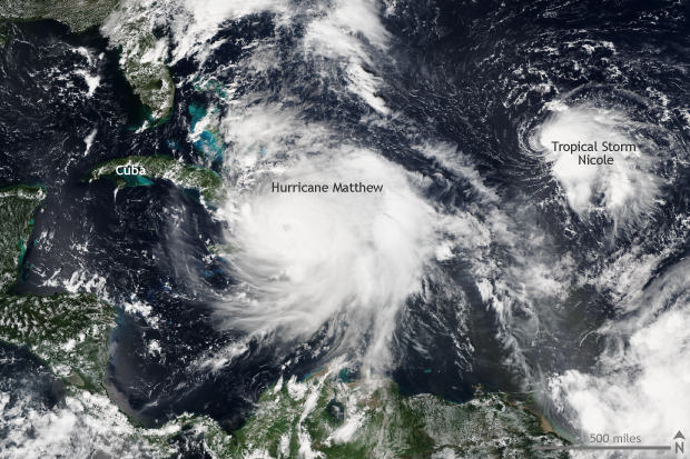
Hurricane Matthew re-wrote the record books across the Caribbean and southeastern United States in early October 2016, leaving behind a trail of devastation. Aided by warm waters in the Caribbean and along the Gulf Stream, Matthew brought strong winds, heavy rains, and high seas to Jamaica, Haiti, Cuba, the Bahamas, and the eastern seaboard of the United States from Florida to Maryland.

Satellite VIIRS, hurricane, Atlantic

Matthew’s origin from normal storm to Category 5 monster

Matthew became a tropical storm close to the Lesser Antilles on September 28, and for several days tracked west as a tropical storm. The storm became named a Category 1 hurricane on September 29. After this relatively slow start, Matthew grew extremely strong, extremely quickly. In the 24 hours after September 30, Matthew intensified from a storm with 80mph winds to a Category 5 behemoth with 160mph winds.
Matthew was the first Category 5 storm in the Atlantic since 2007, and it was the lowest latitude Category 5 hurricane in the Atlantic on record. All of which was even more unusual as it took place in the eastern Caribbean Ocean, a location which has been dubbed a “hurricane graveyard”—a place where low-pressure systems have routinely failed to develop into hurricanes.

Earth's hottest temperatures

What's the hottest Earth's ever been?

Our planet probably experienced its hottest temperatures in its earliest days, when it was still colliding with other rocky debris (planetesimals) careening around the solar system. The heat of these collisions would have kept Earth molten, with top-of-the-atmosphere temperatures upward of 3,600° Fahrenheit.
Even after those first scorching millennia, however, the planet has sometimes been much warmer than it is now. One of the warmest times was during the geologic period known as the Neoproterozoic, between 600 and 800 million years ago. Another “warm age” is a period geologists call the Paleocene-Eocene Thermal Maximum, which occurred about 56 million years ago.
None of that helps with the very early Earth, however. During the time known as the Hadean (yes, because it was like Hades), Earth’s collisions with other large planetesimals in our young solar system—including a Mars-sized one whose impact with Earth is thought to have created the Moon—would have melted and vaporized most rock at the surface. Because no rocks on Earth have survived from so long ago, scientists have estimated early Earth conditions based on observations of the Moon and on astronomical models. Following the collision that spawned the Moon, the planet was estimated to have been around 2,300 Kelvin (3,680°F).

First Snow in the Northeast

First snow on the Northeast after record warm temperatures. 

Snow has fallen over some of the higher elevations of the Northeast this weekend, shifting away from a week of record warmth.
Several locations saw about a half foot of snow in the Adirondacks of New York, according to reports submitted to the National Weather Service.
Snow also accumulated in parts of Vermont and New Hampshire.
Bolton, Vermont, saw 9 inches of snow while Holland was close behind with 8 inches. In New Hampshire, 4.3 inches was measured near Randolph.
Snowshoe Mountain in West Virginia showed signs of transforming into a winter wonderland, providing a snowy backdrop for the USA Cycling Collegiate race Saturday. 
Source: https://www.wunderground.com/news/snow-northeast-new-york-high-elevation