Showing posts with label Samantha Kichka. Show all posts

Thursday, November 29, 2018

Southern US warmup to fuel severe weather event through Friday night

A warm and stormy end to the week will threaten damaging winds, flooding rain and even a few tornadoes as storms tear through the Mississippi Valley. 
Warm air will surge out of the Gulf of Mexico and into the region through the end of the week. After bottoming out at 25 degrees Fahrenheit on Tuesday morning, temperatures in Little Rock will soar into the 70s F on Thursday and Friday. 
This warmth will combine with an incoming storm system to create a favorable setup for severe weather late on Friday, according to AccuWeather Storm Warning Meteorologist Brian Adams.
The impacted region will include "areas from the eastern Plains across the lower Mississippi Valley and into portions of the Ohio River Valley," he said. 
static severe 11/29 am

Sydney suffers heaviest rainfall in years amid extreme weather across Australia

Heavy rainfall flooded roads and train stations across Sydney on Wednesday as Australia's largest city suffered its heaviest November downpour in 34 years.
More than 100 mm (four inches) of rain fell in less than 24 hours across the city, leaving morning commuters trudging through inundated subways on their way into work.
A severe thunderstorm warning was issued by the Bureau of Meteorology on Wednesday for the city and surrounding areas, while some trains and ferry services were canceled.
Stunned Sydney residents posted photos and videos to social media, some of which showed cars driving through rising flood waters as high their car windshields.
    "We have a low pressure system which is lingering over the coast and this has caused quite a lot of significant weather events over New South Wales generally," meteorologist with the Bureau of Meteorology Rosemary Barr told CNN.
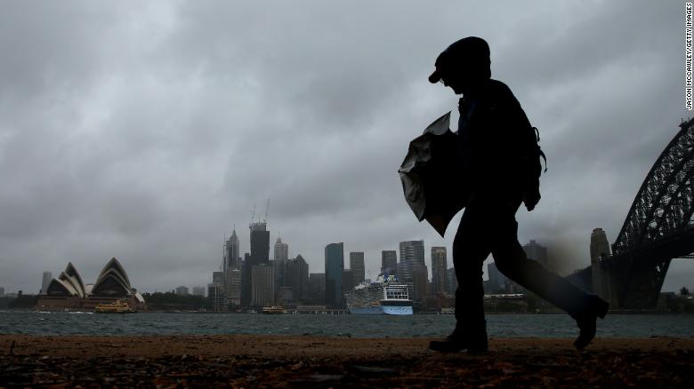
    A man walks in high winds on November 28 in Sydney, Australia.

    Monday, November 26, 2018

    Usagi leaves trail of damage, flooding across Vietnam

    On the heels of deadly flooding and mudslides from Tropical Storm Toraji, Usagi brought more deadly weather to parts of southern Vietnam on Sunday and Monday.
    Usagi briefly strengthened into a typhoon on Saturday before weakening back into a tropical storm as it tracked westward across the South China Sea on Saturday night.
    After making landfall near Vung Tao on Sunday morning as a tropical storm, Usagi continued to weaken into a tropical rainstorm.
    Damaging winds resulted in tree damage, power outages and damage to weak structures in the vicinity of where it made landfall near Vung Tau. 
    According to the VN Express, the popular beach town of Vung Tau was battered by heavy rain and strong winds, resulting in widespread instances of uprooted trees, destroyed roofs and sinking boats along the coast. 
    page-1.jpg

    Nor'easter to lash New England with heavy rain and snow Monday night into Tuesday


    Many places across New Jersey and southern New York received a month's worth of rain on Saturday night. Additional heavy rainfall can worsen existing flooding and lead to more road closures up and down the I-95 corridor.

    Commuters and those heading back to work or school after the Thanksgiving holiday will need to prepare for slowed or rerouted traffic through Tuesday.

    "Rain and fog are likely to lead to airline delays in addition to slowdowns on area highways," Sosnowski said.

    "The storm may evolve into a nor'easter for New England with heavy rain, gusty winds and a brief period of above-normal tides from eastern Massachusetts to Maine."

    The outlook is even more wintry farther north, where the storm is expected to begin as snow or an icy mix into Monday night before changing over to all snow at inland locations late Monday night and Tuesday.
    static NE Monday night 11/26

    More than 800 flights canceled as blizzard warning takes effect in Chicago; worst conditions forecast around midnight for city

    The National Weather Service issued a blizzard warning for the Chicago metro area Sunday 
    afternoon. The warning is in effect from 6 p.m. Sunday until 9 a.m. Monday.
    Issuing a blizzard warning is not common, said National Weather Service meteorologist Ricky Castro.
    “The last time we had one out for Cook County was in February 2015, and then the one before that was February 2011,” Castro said. “So it’s really not a common thing to have a blizzard warning around here, especially this time of year.”
    The weather already is responsible for the cancellation of more than 800 flights from area airports, and transportation officials said car travel will be hazardous as well.
    At the height of the storm, more than 2 inches of snow an hour is possible, according to the weather service, combined with winds gusting 40 to 50 mph. The far northwest suburbs could see about 12 inches of snow, according to the weather service, with 10 inches possible at O’Hare, 6 inches possible at Midway and then several inches likely for the immediate shoreline and downtown Chicago.

    Saturday, November 17, 2018

    India: Cyclone Gaja makes landfall in Tamil Nadu, kills at least 10

    Deadly Gaja will continue to blast southern India with flooding rain and damaging winds into Friday.
    "Gaja made landfall along the coast of Tamil Nadu as a severe cyclonic storm between Vedaranyam and Velankanni shortly after midnight local time," according to AccuWeather Senior Meteorologist Kristina Pydynowski.
    Damaging winds and flooding rain will threaten areas in the vicinity of landfall. Wind speeds of 80-115 km/h (50-70 mph) are expected near the storm's center with gusts to 130 km/h (80 mph).
    Such winds can damage trees and weak structures, as well as cause power outages.
    "As the winds howl, Gaja will also bring a risk for flooding to the areas in the vicinity of where the cyclone comes onshore," Pydynowski said. "A total of 100-150 mm (4-6 inches) with an AccuWeather Local StormMax™ of 200 mm (8 inches) of rain can lead to widespread flooding issues."
    Residents should prepare for road closures, as well as streams and small rivers rising out of their banks and flooding neighboring land and homes. Those living in flood-prone areas may be forced to evacuate their homes.
    Gaja Nov 15 new

    Snowstorm slams Eastern US, killing 8 and knocking out power

    A strong wintry storm still was dumping snow Friday in far northern New England after creating traffic havoc that claimed at least eight lives across the country's eastern half and knocked out power for tens of thousands of people.
    A mix of rain, snow and ice that initially hit the Midwest caused headaches from the South to the Northeast, leaving up to a foot of snow in some parts of the latter and widespread freezing rain and ice accumulations elsewhere. Conditions prompted school closures, hours-long delays for commuters and hundreds of flight cancellations.
    About 200,000 customers in four states were without power at 6 p.m. ET Friday, according to Poweroutage.us, in part due to freezing rain. 
      The snow in the Northeast was expected to end Saturday morning, though gusty winds and coastal flooding will continue, the National Weather Service said. Another cold front will drop additional snowfall from the Great Lakes to the New England interior through Sunday.
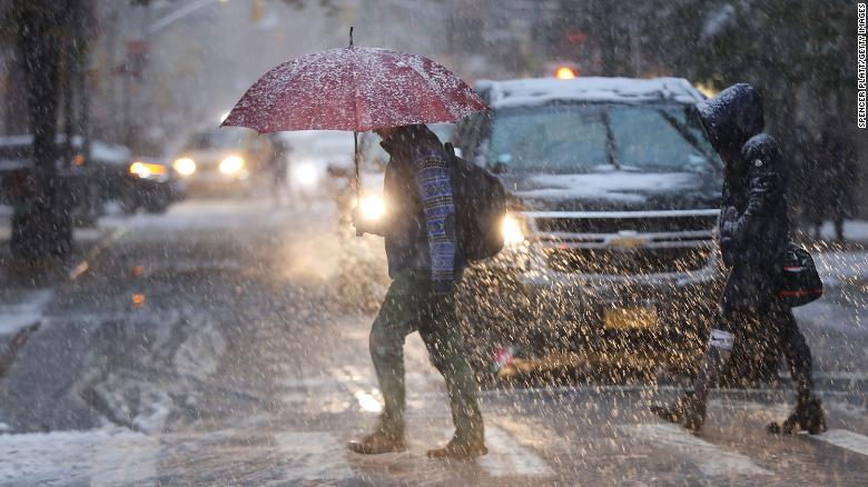
      Pedestrians push through a wintry mix of snow and ice Thursday in New York.

      Tuesday, November 13, 2018

      12 months' worth of rain in 2 days, strong winds and snow hit New Zealand's South Island

      A severe storm brought extremely heavy rain, strong winds and high elevation snow to New Zealand's South Island and lower North Island on November 7 and 8, 2018. In just 57 hours, parts of the region received 652 mm (25.6 inches) of rain - more than it usually receives in a year. 
      "Among the main weather concerns today are heavy rain for the west of the South Island, spilling across the Alps, and severe gales from Canterbury to Wellington," MetService meteorologist Gerrit Keyser said ahead of the storm. "There are numerous severe weather warnings and watches out for the South Island and lower North Island, lasting to Friday."
      "This rainfall event is significant and rivers in both Westland and Canterbury will rise quickly," Keyser said. 
      NIWA meteorologist Benn Noll said the downpour was due to a phenomenon called an "atmospheric river" - a long, narrow region in the atmosphere which transports most of the water vapour outside of the tropics.
      12 months' worth of rain in 2 days, strong winds and snow hit New Zealand's South Island

      Monday, October 29, 2018

      Italy Flooding Inundates 70 Percent of Venice; 6 Killed Countrywide

      Nearly three-quarters of Venice, Italy, was flooded Monday because of a storm system that brought strong winds, driving up water levels more than five feet in the lagoon city, officials said.

      High winds push water in from the lagoon, flooding parts of the city frequently, but Monday's levels were far higher than normal. At its peak, Monday's water level reached nearly 61.5 inches, the highest since December 2008. Water levels were forecast to reach 63 inches above normal levels, which would have been the first time that had happened since December 1979.

      "A strong low-pressure system is spinning through southern Europe, spreading heavy rain and strong winds across northern Italy," said weather.com meteorologist Chris Dolce. "The strong winds triggered the inundation in Venice as they blew from south to north through the Adriatic Sea."

      The storm system was blamed for at least six deaths nationwide. Wind damage that brought down trees and sent objects airborne was to blame for the deaths.


      Image result for venice flooding


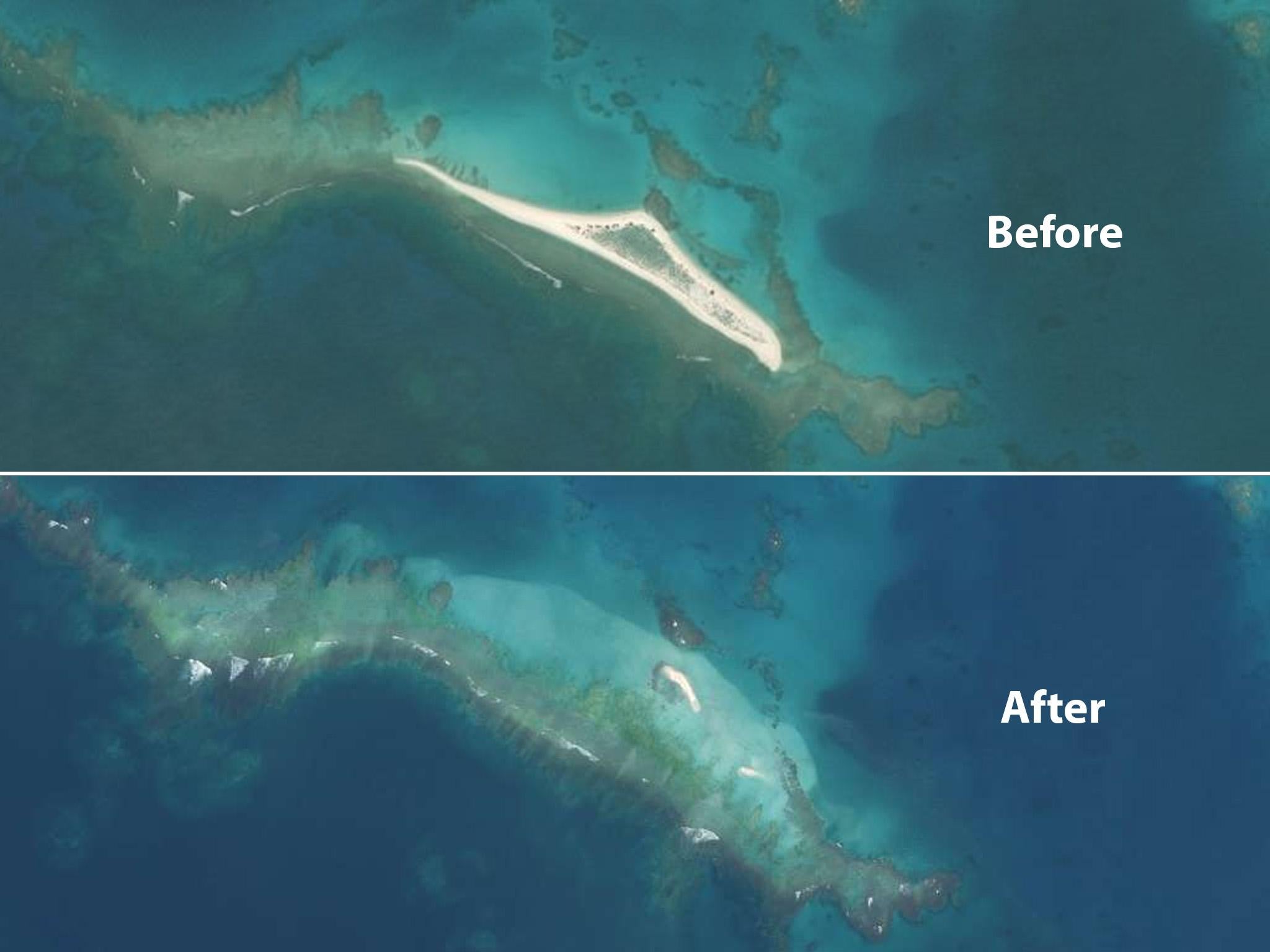
      Hurricane Walaka washes away Hawaii Island where endangered animals nest

      An intense hurricane has wiped a remote Hawaiian island off the map, prompting fears for two endangered species which inhabit the remote spit of land.
      Scientists were studying East Island before Hurricane Walaka hit, and four researchers had even planned to stay there during the storm. When the storm became too intense, they evacuated, and drone footage obtained after the storm revealed the island had disappeared.
      Hurricane Walaka was one of the most intense tropical cyclones on record, but it did not directly hit any major land masses or result in any known human fatalities. Research suggests that climate change has a direct impact on hurricanes, making them longer, more frequent, and more intense.

      25 October 2018

      Extreme Category 5 typhoon, the worst U.S. storm since 1935, leaves Northern Mariana Islands devastated

      Super Typhoon Yutu rampaged through the U.S. Commonwealth of the Northern Mariana Islands on Thursday, leaving behind storm damage that residents are calling the worst they have ever experienced.
      Tied for the strongest storm anywhere in the world this year, Yutu packed sustained winds of 180 mph, and its gigantic eye enveloped much of the island of Saipan and all of Tinian, leaving the Pacific islands “mangled,” as one local official described it to The Washington Post. Rescue and relief operations have begun, but officials say their efforts are hampered by dangerous weather conditions and widespread destruction, which includes “extensive damage to critical infrastructure,” according to a Thursday update from the governor’s office.
      article

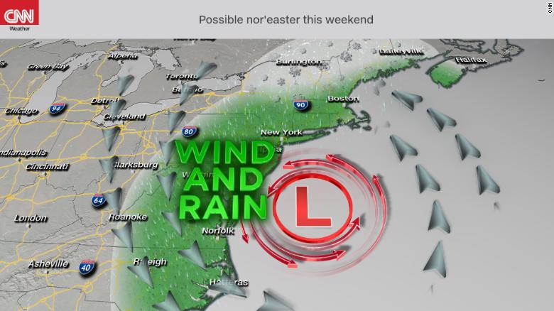
      Nor'easter taking shape, with help from Willa's moisture

      The East Coast is expected to be pounded by the season's first nor'easter this weekend -- helped by remnant moisture from the former Hurricane Willa -- setting up a few days of heavy rain, strong winds and possibly some coastal flooding, forecasters say.

      Rain of 1 to 3 inches is possible from the mid-Atlantic to the Northeast from Friday into Sunday night, and about 16 million people are under coastal flood warnings in New Jersey, New York and Connecticut.
      Wind gusts may hit 60 mph Saturday in eastern Long Island, Cape Cod and Massachusetts' islands. Scattered power outages are possible over much of the region.
      "Go find the best book you can download and get ready for this weekend, because it is going to be a windy, windy, cold weekend in the Northeast," CNN meteorologist Chad Myers said Friday.
      Because the air will be relatively warm -- weekend highs in the Northeast will be in the 40s and 50s -- this nor'easter will be more about wind and rain than snow. But several inches of snow could accumulate in the higher elevations of upstate New York, Vermont, New Hampshire and Maine.


      article


        Wednesday, October 10, 2018

        Hurricane Michael, at Category 4 with 150-mph winds, on path to make potentially catastrophic landfall

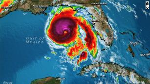
        A potentially catastrophic Category 4 Hurricane Michael is about to make landfall as the strongest hurricane to hit the Florida Panhandle in recorded history, and its winds and storm surge already are wreaking havoc along the shore.
        Michael's extremely dangerous center was only 15 miles from shore at 1 p.m. ET Wednesday, and was about to make landfall between St. Vincent Island and Panama City, the National Hurricane Center said.
          "This is the worst storm that our Florida Panhandle has seen in a century," Gov. Rick Scott said earlier. "Hurricane Michael is upon us, and now is the time to seek refuge."
          Streets already were flooding shortly after noon in the Panhandle city of Apalachicola. In Panama City Beach, video from a meteorologist showed new construction collapsing in high winds in the morning.
          Why Hurricane Michael is a monster unlike any other

          Monday, October 8, 2018

          Tropical Storm Michael Will Soon Be Hurricane Michael

          Tropical Storm Michael will soon become Hurricane Michael as it moves north toward Florida, the National Hurricane Center said Monday morning.
          As of 5 a.m. ET, Tropical Storm Michael is about 90 miles east of Cozumel, an island off Mexico’s east coast, and 100 miles west of Cuba. It is moving north at a speed of around 7 m.p.h. It’s expected to speed up slightly through Tuesday night as it passes between Mexico and Cuba, before tacking northeast on Wednesday and Thursday.
          What’s expected to become Hurricane Michael is forecast to dump between 4 and 8 inches of rainfall on parts of the Panhandle and the Big Bend with isolated downpours of up to 12 inches, potentially causing life-threatening flash floods.
          Tropical sStorm Michael is moving north at around 7mph as of 5am EST.

          Thursday, October 4, 2018

          Hurricane-like Zorba lashes Greece as it barrels toward Turkey

          The eastern Mediterranean is getting battered Saturday as a rare and powerful hurricane-like storm roars across Greece, triggering flooding as it makes its way toward Turkey. 
          The storm, called Zorba, on Saturday morning lashed the Greek coastal city of Kalamata and other spots along the Peloponnese coast, knocking out power in the town of Pylos. 
          Zorba has been dubbed a "Medicane" because of its location in the Mediterranean and its tropical-storm-like qualities. Such storms only occur once or twice a year, usually during September and October, when sea surface temperatures are warm.
          Zorba is expected to be particularly strong in the eastern Peloponnese and eastern central Greece and the Athens region, Greece's National Meteorological Service warned Saturday afternoon. 
          It is also expected to bring gale-force winds by night to the Aegean Islands, where Syrian refugees are crowded into camps.
          Early Sunday morning, the extreme weather will mostly affect the eastern and southern Peloponnese, then move into Turkey, the meteorological service said.

          4 Tornadoes Touch Down in NY, Connecticut, National Weather Service Confirms

          Four tornadoes hit three separate New York counties and one Connecticut county as severe weather walloped the tri-state area Tuesday, the National Weather Service said Wednesday.
          It's the most tornadoes in a day that the tri-state has seen since May 15, 2018, when there were five in the Catskills and Hudson Valley area, according to Storm Team 4.  
          One twister, an EF1 with maximum sustained winds of 100 mph, touched down in Rockland County's Stony Point for about five minutes -- from 4:10 p.m. to 4:15 p.m. -- weaving a trail of destruction a mile long and 300 feet wide. Officials say it started in Harriman State Park and ended near Wilderness Drive.

          Wednesday, September 26, 2018

          6 tornadoes hit Ottawa-Gatineau region

          Environment Canada has confirmed that three additional tornadoes touched down in western Quebec on Friday — bringing the day's total number of twisters in the Ottawa-Gatineau area to six.
          At around 3:30 p.m. ET, a tornado touched down about 30 kilometres from Mont-Laurier, Que., near the Baskatong reservoir, the weather agency said Tuesday.
          It likely travelled about 10 kilometres through the wooded area, snapping trees and downing power poles as it went, Environment Canada said.
          About 90 minutes later, another touched down near the Val-des-Bois, Que, area, about 90 kilometres north of Ottawa.

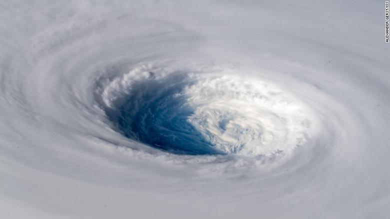
          Super Typhoon Trami: Images show storm from space as it heads for Japan

          Gerst wrote that, from space, the storm looks "as if somebody pulled the planet's gigantic plug."
          Current forecasts suggest the typhoon will affect northern and central Taiwan, as well as Japan's Ryukyu Islands. 
            However, CNN meteorologist Tom Sater said the storm's progress had stalled and meteorologists were still waiting to see where the system may go. 
            "Models earlier in the week wanted to take it toward Taipei, northern Taiwan, others toward Okinawa, a little bit more toward the east -- probably going to see it split the eye here and kinda snake on through the Ryukyu Islands making its way toward western Japan and Kyushu," the country's southernmost island, Sater said.
            The storm still packs sustained winds of around 140 kilometers per hour (87 mph), and Sater says that a "cone of uncertainty" continues to keep the southern Japanese island prefecture of Okinawa "in its eyesight."
            The storm is expected to lose some strength before making landfall in southern Japan in about four days, if it continues to track in that direction. 
            Even after losing power, it's likely to be the equivalent in strength to a category 4 hurricane, adding to the summer of extreme weather that has plagued the Asian nation, Sater said.
            "Pre-typhoon rainfall could cause a threat of landslides; once the system moves in it'll enhance that rain," Sater said.

            Chicago weather: NW suburbs clean up after strong storms leave thousands without power

            HUNTLEY, Ill. (WLS) --
            The damage was so severe in Huntley, that people in one neighborhood compared it to a war zone.
            The winds here in Huntley clocked in at 70 miles-per-hour. Police, fire and building inspectors worked through the night to try to keep residents safe.


            Not only are downed trees and branches now lying in people's yards, but they were blocking several roadways Tuesday night. The high winds stripped trees and tore live power lines right from the poles, sparking a small fire.


            Drivers caught in the storm said they were terrified and homeowners with extensive damage opted to stay with friends and neighbors.


            "As soon as I got just before the railroad tracks, the lines fell, tree split, and it was just insane," said Sandi Altergott, who was caught in the storm.


            Powerful storms Tuesday night knocked down trees and left some people without power, especially in the northwest suburbs.

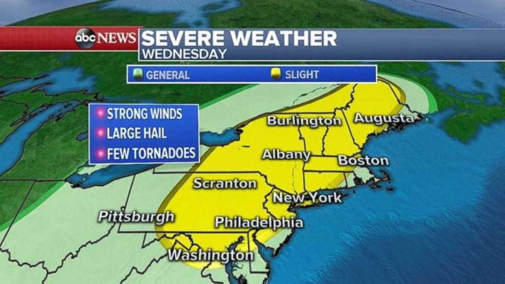
            Severe weather moving into Northeast as rain also falls in Carolinas

            Rain pounded the Northeast on Tuesday with over 8.5 inches in New Haven County, Connecticut, and close to 7.5 inches in Passaic County, New Jersey.

            The story on Wednesday will be severe weather in many of the same areas.
            A cold front will be moving into the Northeast with severe storms that could produce damaging winds, hail and a few tornadoes. A day after flash flooding was seen across the region more is possible.
            Flash flood watches and warnings continue from Tennessee to Ohio and down to the already-soaked Carolinas as more rain is forecast with the cold front.
            PHOTO: Severe weather is moving into the Northeast on Wednesday.