The same contorted jet stream pattern that brought the brutal cold to the lower 48 states pushed a pulse of milder-than-average air into Alaska, where some spots recorded temperatures unheard of for December.
Along Alaska's northern coastline, which lies above the Arctic Circle, the warmest December temperatures on record in at least 70 years occurred this past week.
At the airport in Deadhorse, which serves the oil production hub of Prudhoe Bay, the temperature hit 39°F on December 7, the highest December temperature on record there since at least 1968, said Rick Thoman of the National Weather Service (NWS) in Fairbanks in an interview. Even more notable, perhaps, was the fact that it was raining, rather than snowing. Rain there is unusual so late in the year.
Previously, the highest December temperature recorded at any of the two climate observation sites that have served Prudhoe Bay over the years was 35°F, set on Dec. 31, 1973, according to Chris Burt, a blogger at Weather Underground.
Thoman said it’s possible, but not likely, that other climate stations in that area — such as data collected at now defunct Cold War-era early warning radar stations — recorded slightly milder December temperatures when they were operating in the 1950s and 1960s.
December high temperature records were also set or tied at Barter Island AFB, which is a tiny airport located on a sliver of land along Alaska’s wind-whipped North Slope region, and in the small village of Wainwright, another Arctic shore location. Barter Island reached 37°F, which tied its record last set in 1973, and Wainright hit 32°F, beating the old record of 30°F last set in 2006.
Some weather stations located along the Dalton Highway south of Prudhoe Bay saw temperatures climb into the 40s, Thoman said.
Other noteworthy Alaska records included a December record high of 54°F in King Salmon, which is situated along Bristol Bay in southwest Alaska. That broke the previous record of 51°F, and records there date back to World War II. Daily high temperature records were also set at Kotzebue, Bettles, and Cold Bay, Alaska, among other locations, Thoman said.
The first nine days of December ran 22.2°F above average in Barrow, and 18.5°F above average in Kotzebue, according to NWS data.
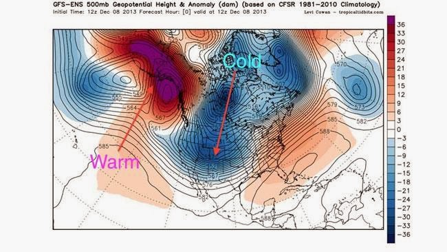
A strong ridge of high pressure was the main cause of the record warmth in Alaska. The high shunted the jet stream, which is a high speed current of winds in the upper atmosphere, to the north of the state, while simultaneously displacing cold, Arctic air southward into Canada and the continental U.S.
Thoman said such weather patterns are not uncommon during the winter months, although the extreme nature of this one was. “This kind of thing does happen with some frequency in the cold season,” Thoman said.
“You get these amplified patterns, and the cold air’s gotta go somewhere, so you build up the ridge somewhere over the Gulf of Alaska ... pump warm air into Alaska, and on the east side of that high, that cold air is going to come plunging south.”
In recent years, studies have shown an association between extremely wavy or “amplified” jet stream patterns, with large ridges and troughs, and Arctic sea ice melt and snow cover decline during the spring and summer months. It's an active area of research, but there’s no doubt that climate change has been having profound impacts in Alaska and other areas of the Arctic region.
The 2012 Arctic Report Card depicted a region undergoing rapid and pervasive changes related to manmade global warming, including the ramifications from plummeting spring and summer sea ice cover, melting permafrost, a rapid loss of spring snow cover, and various other climate change impacts.
The 2013 edition of the Report Card, published by the National Oceanic and Atmospheric Administration, will be released on Thursday.
Recent news reports from Alaska show that increasingly mild fall seasons and erratic weather patterns have had significant effects on local communities.
For example, In Wainwright, changes in weather patterns have diminished the opportunities for subsistence hunters to safely hunt whales and caribou during the fall harvest season, according to a new study published in the journal Arctic.
Alaskans have also seen a precipitous decline in the Western Arctic Caribou Herd, which is thought to be a result, at least in part, of an increase in fall freezing rain events. A colder atmosphere used to produce more snow events, but ice storms have become more common along the caribou’s migration routes, which is helping to thin the herd, according to reporting by the Alaska Dispatch.
Although the long-term forecast calls for continued warming during the next several decades, in the near term, the high pressure area over Alaska is weakening, allowing colder air and snowier weather to return to the Frontier State, Thoman said.
The upcoming weather pattern will be “A big change from what we’ve had, that’s for sure,” Thoman said


 What is a landslide?
 Creep vs. landslide
 A SCARY Invasion
 New Winter Weather Outlook
 REAL Sea Monster Threatens Atlantic
 POISONOUS Spiders Close School
 Is This View Worth $75,000?
 They Did WHAT to These Elephants?
 The Secret Behind the Oarfish Deaths
 A VENOMOUS Discovery
 Why are Wildfires Blazing Australia?
 BIZARRE Target for Bear Attack
 Like Something You've NEVER Seen
 Money Does Grow on Trees!
 Solar on the Rise?
 She Found WHAT in the Dirt?
 THESE Critters Can Survive Nukes!
 Crater Turns Out to Be a Supervolcano
 Tale of Two Storms
 Student Makes SHOCKING Find!
 Cop's INSANE Squirrel Mistake
 Colder Than Average Weekend
 What Is Causing This Rare Occurrence?
 SPACE SUNSETS
 Typhoon Headed for Military Base
 Forecasting the Track of Sandy
 What Shut Down City of 11 Million?
 Proof They Are All Different
 A Warning for the Rockies
 Dinner, or Future Energy Source?
 Bizarre Items Found in Dolphin
 Help Name Lion Cubs!
 Frosty Southeast
 Raymond Downgraded and Moving West
 It's our Fault These Animals are Extinct
 NASA Sets Download Speed Record
 BIG Surprise for Shoppers
 Where is the World's Deadliest Road?
 Life from the Ashes
 Research About Air Pollution
 Life In Our Solar System?
 Chilly Start Expected For World Series
 More Hurricanes Than Expected?
 Cat SURVIVES Rooftop Journey
 Playing Catch with Jerry Rice
 SHOCKING Hotspot for Great White Sharks
 Weather and Football with Jerry Rice
 The Big Picture
 Corn Maze a Cash Crop For Farmers
 Frosty Southeast
 Russian Activity Alerts U.S.
 Alligator in Hot Tub Came with House?
 America's Most Amazing Landscapes
 Riskiest Adrenaline Rush?
 Second 'Sea Monster' Washes Up
 High Sea Rescue Caught on Video
 Wildfires Force State of Emergency
 Drones Seen as Storm Warning Solution
 Elephants Make Journey to California
 Face to Face with a Mega-Fire!
 BEWARE: #1 Place to Drown
 Can Joint Pain Predict Weather?
 $1 Million for WHAT?
 Snow and Cold in Michigan
 Is Air Pollution Causing Cancer?
 About to Catch a Comet!
 Train Derails into Fireball
 Hardest Job in the World?
 Escaped Bull's LETHAL Move
 NEW Asteroid Threat
 Snake Every Square Yard
 UFO Debunked
 Dolphin Slaughter
 Can This Dessert Cure Your Cold?
 Bushfires: State of Emergency
 Olympic Trials Update
 From the Front Lines
 How to Measure Snow
 Underwater Pumpkin Carving
 Who's Getting Snow?
 How Sleep Helps Clean Your Brain
 Space Facts to Knock Your Socks Off
 Australian Wildfire Update
 These are Invading!
 Largest Star Ever Discovered is DYING!
 A 'Zombie' Car?
 'Yeti' Mystery SOLVED?
 Mysterious, Killer Fungus
 Historic Church Crumbles on CAM!
 You'll NEVER Be Found Here!
 Fire: Homes Destroyed, Many Evacuated
 Glass from LIGHTNING?
 THIS Can Survive a Nuke Attack?
 Skull Contains SECRETS about Us!
 Wilma's Devastating Effects
 The Sun is Thermonuclear?
 Olympic Flame Heads to Space
 Too Cold for the Marathon?
 Evacuation Could Have Saved Lives
 X-RATED Weather Effects?
 SHOCKING End to Bear Attack
 18-Foot WHAT?
 National Park: Now Open
 Weather Blamed for Deadly Crash
 Getting Ready for the Kansas City Marathon
 Olympic Torch Going to Space
 Bizarre End to Tiger Attack
 Treasure Hunters Make SHOCKING Find
 Huge Meteorite Pulled from Lake
 South Dakota Like You've Never Seen
 Need Underwater Internet Access?
 Nature's Deadly Secret Revealed
 How is NASA Still Tweeting?
 Shocking Video: Great White Circles Boat
 Highway Alligator ON THE LOOSE?
 Real Jurassic Park Around the Corner?
 Building A Homemade Space Suit
 When Would You Leave a Game?
 Jumping Through the Atmosphere
 Low Water Level Reveals Treasures
 A Fall from the Edge of Space!
 Weather Found to Perpetuate Poverty
 Sunny Sweeney Sings on Wake Up With Al
 Drinking Wine at 7am!?
 Sunny Sweeney Does the Weather
 Science Behind: Antarctic Research
 Science Behind Cimate: Oceans
 Weather Lab: Fog
 Close Call with Shark
 Wilma Sets Record
 Second Ski Resort Opens in CO
 Your Leaf-Peeping Forecast
 Death Toll from Quake Grows
 Hungry Bears Trapped!
 Al's Top 3 October 17
 Wake Up With Al Weather Headlines
 Your Endangered Dinner is Served?
 Unbelievable Bridge Collapse
 Why Are Dolphins Dying?
 Bacteria Lurking in Sea Water Kills 10
 Giant Air-Breathing Fish Discovered
 CRAZY: Rescued Bear's New Talent
 New Views of Amazing Landmarks
 Typhoon Leaves 14 Dead in Japan
 Are Miracle Cures Hiding Here?
 If The Earth EXPLODED!
 Meet the HELLBENDER!
 An Electrifying Fishing Trip
 Giant Shark Caught ON CAMERA
 How Did They Survive?
 Prosthetic Limb Provides Sense of Touch
 The Shrinking Airline Seat
 Not seen in 30 YEARS!
 Turning Air Into Plastic
 What's WRONG With This Gator?
 Can You Dig It?
 Dirt Fight!
 Five Surprising Cities Primed for Disaster
 The Big Picture
 What's Killing Them?
 Is THIS Iran's Newest Astronaut?
 Unsettled Weekend Ahead
 Most Remote Place on Earth?
 Door Falls Off Plane, Lands on...
 LAX Bomb Made of WHAT?
 Could This Destroy Earth?
 20.000 Bees Found WHERE?
 Still Recovering After Floods
 Storm Watch
 Emergency Exception to Shutdown
 Angels in Deadwood, SD
 A National Look at the Next 3 Days
 Tour of the Space Shuttle Endeavor
 Buildings at Risk of Collapse
 Running Toward a Better Life
 Ski Season Begins!
 Private Rocket Reaches New Height
 Beware: They're Coming...
 Rare Images of Russian Volcano
 Giant Gator Killed with WHAT?!
 Warm Your Hearth, with Trash!
 Forecast for the Coming Week
 What Caused This?
 World's Largest Wave Making Machine
 STUNNING: Places to Visit at Low Tide
 Stunning Images of Earth
  Preparing for Sochi Olympics
 Surviving Pirates and Hurricanes
 Cyclone Phailin Devastates India
 Typhoon Affects USA
 E Coli Found After Floods
 Atlas Cleanup Continues
 Good News for Pumpkins
 Early Start to Ski Season
 Comet Explodes WHERE?
 Shocking End to Shark Attack
 Hunters Kill Holy Moose
 THIS Can Eat a Sheep?
 Saturn Rains WHAT?
 Crocodile Invades Restricted Army Base
 Are These the Gates of Hell?
 Russians Train Dolphin To...
 Nature's Deadliest Poisons
 Bizarre Weather Phobias
  Scientist Finds Tick WHERE?
 Cute Alert: Baby Panda Sunbathes!
 Time-Lapse: Storms Over New York