Showing posts with label Stephanie Torres. Show all posts

Saturday, April 27, 2013

Cautious Relief in Midwest as River Levels Fall


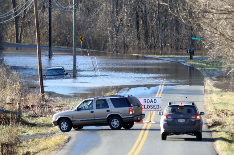
PEORIA HEIGHTS, Ill. -- Slowly retreating flood waters gave Midwesterners some hope Wednesday that the worst was over, but many worried that the earthen and days-old sandbag levees along the Illinois and Mississippi rivers could still fail.
Fast-moving currents were testing makeshift protections around Dutchtown, Mo., where the Mississippi was expected to rise well above flood stage later this week and potentially send water into the scattered homes and businesses that comprise the tiny, unprotected river town.
In downtown Peoria, Ill., tens of thousands of white and yellow sandbags stacked 3 feet high lined blocks of the scenic riverfront, holding back Illinois River waters that already reached a 70-year high and surrounded the visitors' center and restaurants in the 114-year-old former train depot.

http://www.weather.com/news/major-flooding-chicago-20130418

Tuesday, April 23, 2013

Twin Cities weather: Disgusting Snow


Forget the multiple rounds of heavy April snow. Most, if not all, of the snow-cover will melt in near-70-degree temperatures in just a few days.
The latest springtime snowstorm to batter the Twin Cities ended up dropping about 4 inches of snow at the Minneapolis-St. Paul International Airport by Tuesday morning, April 23, according to observations from the National Weather Service.
That amount held true for most of the metro area, with the heaviest snow -- a band of 6 and 7 inch accumulation -- falling to the south, in the Lakeville and New Prague areas.
The storm threatened to dump up to 9 inches of snow in the metro, a figure that would have made this April the snowiest in Twin Cities recorded history, surpassing a total....

Friday, April 19, 2013

Thunderstorms snarl traffic at Chicago airports

Hundreds of flights have been canceled at Chicago’s O’Hare International Airport due to thunderstorms.
The severe weather has led to more than 500 cancellation at O’Hare and more than 30 cancellations at nearby Midway International, Chicago Department of Aviation spokesperson Gregg Cunningham told NBC News.
Strong storms and wind are expected in the region throughout Thursday. Delays for some flights heading into O’Hare average more than five hours, according to the Federal Aviation Administration.

Monday, April 8, 2013

Weather will fast-forward to summer this week!


Weather will fast-forward to summer this week as temperatures rise into the 80's!

After a long winter and a chilly spring, New Jersey is heading into summer this week.
It all starts this afternoon when most of New Jersey will have sunshine and highs around 70 degrees, according to Accuweather forecasts.
Tuesday will be even warmer with temperatures close to 80, and Wednesday will be even warmed, said Paul Walker, a senior meteorologist at Accuweather.

Thursday, April 4, 2013

The Critical Decade


The Critical Decade: Report Links Australia’s Extreme Weather To Climate Change

A new report confirms that the extreme heat waves, floods, droughts and wildfires that have wracked Australia over the past decade have been exacerbated by climate change. 
The report, commissioned by the Australian government’s Climate Commission, makes clear that these weather events will only get worse in the coming years, and warns that health and emergency professionals as well as citizens must prepare for their impacts now.
The study’s chief commissioner Tim Flannery said the study’s results mean Australia needs to take action to slow climate change.

Saturday, March 30, 2013

The Last Shot of Cold Weather


The Last Shot of Cold Weather... Snow and Severe Weather


I am starting to see a transition of the cold weather to one that more like early spring. 

The A.O is coming up, the N.A.O is going to positive and the P.N.A is going negative which all means a reversal of the weather pattern across the eastern part of the country. As I said before, it's a long and windy road getting there, but we will get there.
The next shot of cold weather is coming down the slide later this weekend into early next week. We have some severe storms ahead of that front across the southern Plains which can produce large hail and damaging wind gusts.
http://www.accuweather.com/en/weather-blogs/meteomadness/the-last-shot-of-cold-weathersnow-and-severe-weather/9098302

Friday, March 29, 2013

A Lamb-like Easter Weekend-Weather Wisdom with David Epstein

A Lamb-like Easter Weekend!

    The end of March is fast approaching and when it’s over, this month will go down in the record books as a cold and snowy one. The good news is the lamb will indeed lead us into April this year. You probably noticed a lot of clouds around the area the past couple of days and today will continue that trend. A weak bit of energy will rotate through the area during the day and this will produce periods of clouds with just the risk of a shower. Any rain that falls will be light and not last long.

The weekend is looking quite nice. When you get up Saturday there may be a few clouds, but the trend will be for increasing amounts of sunshine and mild temperatures. 

http://www.boston.com/news/weather/weather_wisdom/2013/03/a_lamb-like_easter_weekend.html


Saturday, March 23, 2013

Severe weather possible along coast


Golf Coast could see Severe Weather!

Meteorologists say an unstable weather system poses a threat for hail and severe thunderstorms in south Alabama.
Forecasters expect a warm front to move north through the region Saturday and say there's a possibility of hail throughout the afternoon.
Meteorologists say the warm front will become increasingly unstable as it moves northeast. 


Wednesday, March 20, 2013

Hazardous Weather on First day of Spring


Hazardous weather outlook on 1st day of spring


As spring officially arrived this morning, the National Weather Service issued a "hazardous weather outlook" warning of subzero windchills followed by snow showers.

And it doesn't get much better in the days ahead. The Chicago Weather Center says computer models "are beginning to agree" that the area will be hit with a snowstorm Sunday through Monday.

Spring arrived at 6:02 a.m. Two hours into the new season, wind chills were clocked at -4 in Aurora, -3 at DuPage Airport and -1 at O'Hare and Midway airports and in Waukegan and Wheeling.


http://www.chicagotribune.com/news/local/breaking/chi-hazardous-weather-outlook-on-1st-day-of-spring-20130320,0,6886300.story

Friday, March 15, 2013

Severe Weather concerns next Week


Severe Weather, Flooding, Coastal Concerns Next Week

A complex storm heading eastward next week will bring the potential for severe thunderstorms, flooding from heavy rain and coastal erosion.
The same storm forecast to bring heavy snow and strong wind from parts of the Midwest to the East into next week will have other potential disruptive and damaging characteristics.
The concerns go beyond slow travel on the highways and delays at airports from poor visibility and wind.
Severe Weather
On the list of concerns is the potential for severe thunderstorms over part of the Ohio and Tennessee valleys, perhaps extending toward the Gulf Coast and the southern Atlantic Seaboard Monday into Tuesday.

http://www.accuweather.com/en/weather-news/severe-weather-flooding-coasta/8170698

Tuesday, March 12, 2013

Long-Term Droughts in Southwestern N. America


Monsoon Failure Key to Long Droughts in Southwest


Long-term droughts in the Southwestern North America often mean failure of both summer and winter rains, according to new tree-ring research from a University of Arizona-led team.The finding contradicts the commonly held belief that a dry winter rainy season is generally followed by a wet monsoon season, and vice versa.
The new research shows that for the severe, multi-decadal droughts that occurred from 1539 to 2008, generally both winter and summer rains were sparse year after year.

"One of the big questions in drought studies is what prompts droughts to go on and on," said lead author Daniel Griffin, a doctoral candidate in the UA School of Geography and Development. "This gives us some indication that the monsoon and its failure is involved in drought persistence in the Southwest."

http://www.sciencedaily.com/releases/2013/03/130311151120.htm

Friday, March 8, 2013

Severe Weather Threat


Severe Weather Threat: Amarillo, Dallas,  Austin 

A storm system emerging from California on Friday will ignite powerful thunderstorms from the Texas Panhandle to the central Plains Friday night through Saturday.
The thunderstorms will come in two rounds. The first round will fire just after sundown Friday.
Locations most at risk from this opening act of severe weather will be across the Texas Panhandle, from Midland northward to Lubbock, Amarillo and Pampa. These are the same places that were blasted by a blizzard just two weeks ago.
Hail the size of quarters, ping pong balls or even tennis balls will be capable of breaking windows, smashing windshields and injuring unsheltered livestock.
There is also the potential for wind gusts up to 60 mph, which can kick up dust, damage siding on houses, and bring down tree branches or power poles. A tornado spin-up or two can also not be ruled out.
http://www.accuweather.com/en/weather-news/severe-weather-threat-amarillo/7655995

Monday, March 4, 2013

U.S Storm Moves East with Snow Forecast


Chicago and Minneapolis could receive blizzard conditions....


Meteorological spring may have officially started on Friday, but someone forgot to tell Old Man Winter. A large winter storm is currently developing over the Dakotas and is expected to spread east over the US in the the next three days. Snow is possible from Minneapolis all the way to Boston, though much uncertainty remains in the track of this storm system.

The most confidence I have in the forecast is in the northern midwest including in Minneapolis and Chicago. Winter storm warnings are in effect throughout the region for 6-12in of snow for Monday through Tuesday evening. Snowfall could fall at rates from 1-2in per hour Monday night into Tuesday. Winds on Tuesday could be between 15mph and 30mph – creating near blizzard conditions.

http://www.guardian.co.uk/world/2013/mar/04/us-storm-moves-east-snow

Friday, March 1, 2013

Winter Storm drops Snow from Missouri to Maine


Winter storm drops snow from Missouri to Maine


            A winter storm coated a swath of the country from Missouri to Maine with snow Wednesday, and forecasters warned of difficult travel. About 100 flights into and out of Chicago’s O’Hare airport were canceled by midday, according to FlightAware.com, on top of more than 500 the day before. 

Chicago had almost 5 inches of snow Tuesday, bringing its total for February to 14.9 inches and ranking it among the 20 snowiest months on record, according to NBCChicago.com.
As the storm moves east, it is expected to dump 6 to 10 inches of snow Wednesday and Thursday from the Allegheny Mountains of western Pennsylvania through the Adirondacks of upstate New York and into interior New England.
LINK- http://usnews.nbcnews.com/_news/2013/02/27/17112788-winter-storm-drops-snow-from-missouri-to-maine?lite

Monday, February 25, 2013

County Responds to Severe Weather


County Responds to Severe Weather


Officials encourage use of Leon County’s Emergency Information Portal and Emergency Alerts Leon County Emergency Management continues to closely monitor the current weather situation related to severe weather including thunderstorms and flooding.
As a result, Leon County Emergency Management and Leon County Public Works have made sandbag operations available for residents to use.
Officials encourage use of Leon County’s Emergency Information Portal and Emergency Alerts Leon County Emergency Management continues to closely monitor the current weather situation related to severe weather including thunderstorms and flooding.
As a result, Leon County Emergency Management and Leon County Public Works have made sandbag operations available for residents to use.

http://www.wctv.tv/home/headlines/Sand-and-Bags-Being-Offered-in-Tallahassee-193084641.html


Friday, February 22, 2013

Maryland Weather: Forecast saids afternoon snow and sleet


Maryland Weather: Friday weather forecast includes afternoon snow and sleet


Snow and sleet could move into a cloudy Baltimore region on Friday afternoon, complicating the afternoon commute and changing to rain or freezing rain in the evening hours, according to the National Weather Service.
But forecasters said Friday morning the chances of any meaningful precipitation for the Baltimore area are waning.
According to Foot's Forecast, "the storm has really fizzled before it can bring a hazardous commute today, but some smaller impacts are expected."

http://www.baltimoresun.com/news/weather/weather-blog/bs-md-weather-20130222,0,6995187.story

Monday, February 18, 2013

Midweek Severe Weather Risk Texas to Mississippi


Severe Weather Risk Texas to Mississippi


As a major storm swings out of the Southwest, there is the potential of violent thunderstorms sweeping from western Texas to the lower Mississippi Valley during the middle of the week.
The setup has the potential to bring a significant severe weather outbreak, by way of a developing squall line. The most common characteristics of the severe thunderstorms will be damaging wind gusts, hail and blinding downpours. However, a few of the storms will bring the potential for a tornado.

http://www.accuweather.com/en/weather-news/midweek-severe-weather-texas-to-miss/6401028

Friday, February 15, 2013

Rain, thunderstorms could complicate Miss. twister cleanup efforts


Rain, thunderstorms could complicate Miss. twister cleanup efforts


Rain and thunderstorms were likely to complicate work Tuesday to clean up the debris strewn across southern Mississippi by a tornado, which left residents marveling that no one died despite the severity of the destruction.
Roofs were torn from homes and massive trees were tossed across houses. In one part of Hattiesburg, the bricks that had once formed the wall of a church were thrown onto a pickup truck, leaving very little of the vehicle intact.

Storm victims described close calls as the tornado roared across several counties. Officials said that while more than 60 people were hurt, no one died. They said the human toll could have been much worse, but the nature of the storm allowed forecasters to give people ample warning. 


Read more: http://www.foxnews.com/us/2013/02/12/rain-thunderstorms-could-complicate-miss-twister-cleanup-efforts/#ixzz2KzSS3uCB

Wednesday, February 13, 2013

January: The Month of Unusual Weather


A Month of Unusual Weather


The weather has been very peculiar. "It's not unusual to have swings in the weather from warm to cold at this time of year, but this has been pretty big swing and that is unusual," said Jared Klein a meteorologist with the National Weather Service's Sterling office. "I mean, 74 degrees a few days ago and it was 23 degrees for a high a few days before that; that's a pretty wide range."

"It's definitely not normal, but the swing itself is not unusual," Klein said. "For instance, the warm temperatures are common for this time of year. We had 81 degrees on Jan. 30, 2001; 74 degrees on Jan. 4, 2005 and 74 degrees on Jan. 29, 2002."
Klein noted that weather service statistics only go back to 2001 as the service switched monitoring locations.

http://www.dailyprogress.com/news/article_ca8e065a-6c23-11e2-b210-001a4bcf6878.html

Monday, February 11, 2013

Snowfall Totals Across Northern Illinois


Snowfall Totals Across Northern Illinois


The National Weather Service released its final list of snowfalls totals today.
As of 10:30 a.m., the highest total was in Beach Park, which saw 9.6 inches. Many other communities, like Bourbonnais and Bridgeview, saw just a trace of snow.
Early snowfall reports on the National Weather Service Chicago website show a range of totals, from 2 inches in Elk Grove Village at 6 p.m. to 7 inches in Beach Park. The totals were reported to the National Weather Service by broadcast media, trained public, residents and CoCoRaHS, or the Community Collaborative Rain, Hail and Snow Network.

http://desplaines.patch.com/articles/winter-storm-nemo-leaves-up-to-7-inches-of-snow-across-northern-illinois?ncid=newsltuspatc00000001