Showing posts with label Temprance Berry. Show all posts

Wednesday, April 24, 2013

Kenya's rains claim more victims


Widespread flooding sees death toll rise during country's monsoon season.

 Last Modified: 18 Apr 2013 09:45
Two children have become the latest casualties of Kenya’s recent flooding woes. The youngsters were buried in a landslide in Narok County on Wednesday after a heavy downpour destroyed homes and farms. It is believed they were buried alive as they slept in their beds.

The death toll from the rains now stands at 41 and the Kenyan Meteorological Department has warned that the worst may be far from over.

Saturated ground and the prospect of a long rainy season could see flooding continue well into May, they have warned.

The government has attempted to alleviate the suffering by allocating the equivalent of US$19M to replace destroyed infrastructure, and helping the many thousands of villagers who have been displaced by the flooding.
http://www.aljazeera.com/weather/2013/04/201341892335158560.html

A Few Severe Storms Possible

Published: Apr 24, 2013, 5:46 AM EDT weather.com


A limited threat of severe storms stretches from central Pennsylvania to West Virginia on Wednesday. Localized damaging wind gusts are the main threat.
Background
Beyond Wednesday, the next chance of a few severe storms will be on Friday in parts of northern Texas and southern Oklahoma.

Severe weather, tornadoes could lash Plains overnight


Tornadoes could hit Oklahoma, Texas, Missouri, or Kansas.
A severe weather outbreak is possible in the central and southern Plains overnight.
The National Weather Service has issued a tornado watch for parts of Oklahoma, Texas, Kansas, Missouri and Illinois. The greatest risk for tornadoes is in central Oklahoma, southeastern Kansas and central Missouri, according to the Storm Prediction Center in Norman, Okla.
Forecasters at the center say there's a "moderate" risk of severe thunderstorms Wednesday afternoon and night. The storms may be accompanied by tornadoes, large hail and damaging winds. The tornado watch expires at 11 p.m.

http://www.usatoday.com/story/weather/2013/04/17/tornadoes-severe-weather-plains-midwest/2091419/


As the rains poured, the waters rose
The rain caused flooding in parts of the Western Cape, including in this informal settlement in Khayelitsha, Cape Town

Welcome rain for drought-hit New Zealand


Torrential rain has put an end to New Zealand's most extensive severe drought in over 30 years

 Last Modified: 23 Apr 2013 10:28

Heavy rain has put an end to New Zealand’s most widespread drought in 30 years. Farmers here welcomed the downpours over the weekend, but despite the rain, much of New Zealand expects to keep a drought declaration in place until September.

The heavy rain set in on Saturday and most of the country has seen heavy and persistent rainfall for the last three days. The city of Tauranga was soaked with over 210mm of rain over the weekend, which caused some flooding.

The drought began in December and gradually extended right across the North Island. Farmers estimate losses approaching two billion New Zealand Dollars (US $1.7B) in export earnings after they were forced to reduce their herds and cut back on milk production. This amounts to around one per cent of the economy.

Global dairy prices have risen over the past six weeks, partly in response to the drought. The rain does provide some relief to dairy farmers who are now busy planting grass seed to try to take advantage of the rain.

Cyclone Sandra threatens New Caledonia


The island nation is on alert as weather conditions begin to deteriorate
 Last Modified: 11 Mar 2013 09:52
In the Coral Sea, Tropical Cyclone Sandra continues it track to the south and is still a threat to New Caledonia.
The country’s nickel mining operations have been put on alert Monday as winds gust to over 200kph could be the biggest threat in the next 24 to 48 hours.
New Caledonia’s top nickel producer, Societe le Nickel (SLN) is preparing to suspend mining operations in the northern part of the main island. It is just one of the companies that is mining in the country that holds the world’s largest deposit of nickel.
Cyclone Sandra is expected to begin weakening from Monday evening. The center of the storm is forecast to pass just west of the island.
Not only will the wind gusts be of concern, but also the flooding rainfall. Over 140mm of rain could be seen over this mountainous terrain in 48 hours. Flash floods, mudslides and power outages are being expected.
http://www.aljazeera.com/weather/2013/03/201331195134359319.html

Tuesday, April 23, 2013

Deadly landslide hits Indonesia


Days of heavy rain have led to another landslide in Indonesia. There have been over 50 landslides here so far this year


 Last Modified: 26 Mar 2013 10:20

A landslide has been triggered by torrential rainfall on Indonesia’s main island of Java. At least eight people are known to have died with nine others still missing.

Semarang in Central Java had 57mm of rain on Monday, and the heavy rain has been on-going for over three days now. The landslide occurred at the Muka Payung village in Cililin in west Bandung district.

Nine houses were buried when mud gushed down from surrounding hills just after dawn on Monday. Indonesian search and rescue officers and military personnel are still looking for victims according to a disaster official.

Rescue attempts have been hampered by a lack of equipment. Over 300 policemen, soldiers and residents had to use shovels, hoes and their bare hands to search through the debris for the missing.


Severe storms cause Mississippi mayhem


Torrential rains led to widespread flooding across parts of the American the Midwest and there is more rain to come

A state of emergency has been declared across much of the Midwest in the USA after heavy rain caused widespread flooding.  At least three people are known to have died as rivers, streams and creeks overflowed.

No less than six states have been affected. On Sunday, more than 45 rivers or streams were in major flood in parts of Missouri, Iowa, Illinois, Wisconsin, Indiana and Michigan. 

The floods have reached record levels in parts of Illinois and Michigan. The rain was heavy enough in Chicago to rip open a sinkhole large enough to swallow three cars. One driver required hospital treatment.

Burlington, Iowa saw the Mississippi River reach its fourth highest level since records began after severe weather brought hail storms and 175mm of rain to the region. A number of people were trapped in their cars and there were mudslides with dozens of roads and bridges damaged or blocked.

In Indiana, the high waters threatened several towns, forcing hundreds of people to evacuate their homes. The Wabash River in Tippecanoe County reached its highest level since 1958.http://www.aljazeera.com/weather/2013/04/201342294436422738.html

Saturday, March 9, 2013

Madagascar and the Philippines flood threat


Two tropical systems have recently developed, both are relatively weak, but could cause some flooding.

The global weather is fairly quiet at the moment, but we do have two tropical systems which have recently developed. They are both relatively weak in terms of the winds contained within them, but both have the potential to cause life-threatening floods to their areas of influence.

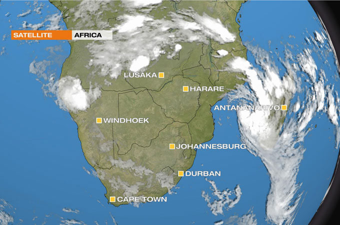
The first storm, Tropical Cyclone 16S has been brewing up for the last few days in the Mozambique Channel. It currently has sustained winds of 65kph gusting to around 85kph. 

This really is not too impressive in terms of tropical storms, and does not even register on the Saffir-Simpson scale (used to measure Atlantic hurricanes). However, the storm is very well organized and is likely to strengthen further over the next 36 to 48 hours. 

By Thursday it is expected to peak with winds nearer 110kph gusting 150kph (equivalent to a category one hurricane). At this time the eye of storm will be approaching the southwest of Madagascar. The strongest winds will be on the Madagascan side of the system, so heavy seas and storm surges are expected to increase the likelihood of flooding.

Parts of western Madagascar have been reporting 50 to 60mm of rain per day for the last two days. It is certainly possible that some areas here could see over 400mm of rain over the next 48 to 60 hours as the storm intensifies.

The flood threat is enhanced by the fact that the storm will not clear the south of the country until the weekend. Hence the heavy rain will sit over the area for many hours or even days.

The other tropical system giving cause for concern is called Tropical Depression 02W and it is now moving over the southern Philippines. Here the winds are no more than 45kph gusting 65kph and they will maintain that kind of intensity until the storm reaches the South China Sea, but even then they will only strengthen to around 65kph.

The encouraging news is the storm is moving westwards fairly quickly at 20kph. That is just as well when we consider the impressive totals already notched up. 

http://www.aljazeera.com/weather/2013/02/2013219103843896679.html

Athens under water


The Greek capital is reeling after the worst rainstorm in half a century.

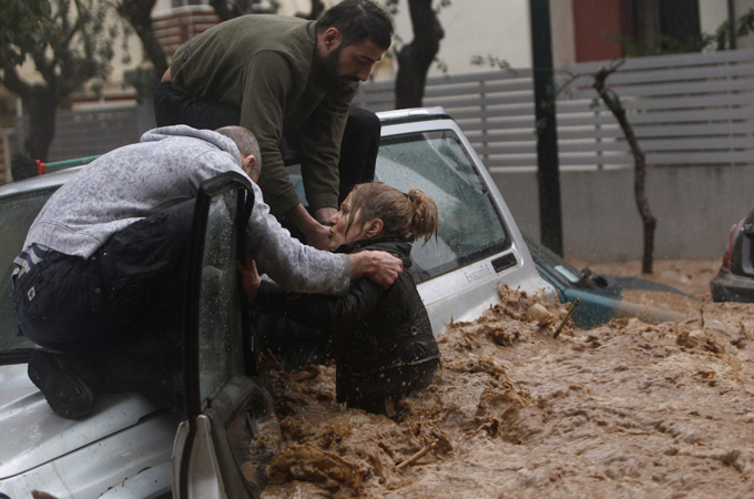
The worst storm to hit the Greek capital of Athens in more than half a century has left one person dead and caused widespread flooding.

Rain was reported to be falling in the city from 0300GMT on Friday. During the next five to six hours there was a deluge of around 100mm. This compares with an average for the whole of February of 50mm.

Two rivers overflowed and electricity substations were submerged, plunging parts of the city into darkness.

Emergency services dealt with 1,500 calls from residents whose homes were flooded, and around 100 motorists trapped in their vehicles.

The only fatality reported so far, is that of a 28-year-old woman who died from a suspected heart attack whilst trapped in her car.

Although the intensity of the rain was exceptional, the city’s antiquated drainage system is considered inadequate to cope with heavy rain and flooding is a common occurrence.

An assessment of the full extent of the damage has yet to be made but in a debt-ridden country, struggling to make payments of billions of euros to foreign creditors, the flooding could hardly have come at a worse time.


Afghanistan braces for severe weather


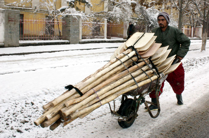
A weather system is currently sweeping across parts of Pakistan and Afghanistan which promises to bring severe weather to the region for the next few days.
The heavy rain and snow has already started to fall in many parts of Afghanistan and the Khyber Pakhtunkhwa in Pakistan.
The rain will turn increasingly wintry during the remainder of Tuesday and on Wednesday.
The heaviest of the snow is expected over the Hindu Kush, the vast mountain range that stretches across Central Afghanistan and into Pakistan. Up to 1.5 metres of snow is forecast by the time the storm clears away on Thursday.
This is the wettest time of year in eastern Afghanistan, when the cold air from Asia is fighting with the warmer air from the south. This often triggers violent thunderstorms; another weather system brought heavy snow to the regionearlier in the month.
The competing weather systems can also generate wildly fluctuating weather; on Tuesday night, Kabul is expecting snow and a minimum temperature of -2C, but by Saturday, the temperature should climb to a warming 16C.
Heavy rain and snow cause major problems across the region almost every year. The rural housing offers little protection against the torrential rain, and have been known to collapse on their occupants.
More intense weather systems are expected across the region over the next few months. The rainy season finally draws to a close at end of April, when the weather turns hot and dry.


http://www.aljazeera.com/weather/2013/02/20132269281239497.html

Australia braces for floods


Torrential rain threatens to bring treacherous conditions to parts of New South Wales.
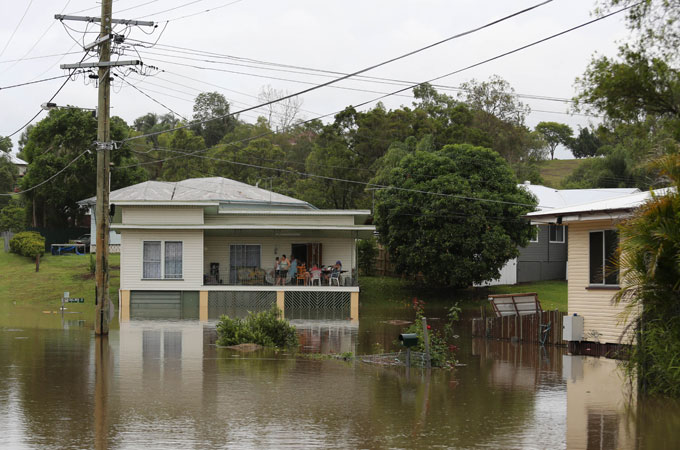
Over the past few days torrential rain has been falling across the east coast of Australia.
An area of low pressure which has been drifting down the east coast of Australia. Originally the system moved down the Queensland coast, bringing flooding to some eastern locations.
The town of Rainbow Beach, just to the north of Great Sandy National Park received 326mm of rain in three days, which is approximately twice the amount of rain that would normally be expected in the entire month of February.
The system is continuing its journey south and over the next 24 hours, it will be parts of New South Wales which will see the heaviest downpours.
The coastal stretch of the state to the north of Sydney is likely to be the worst hit, with most places expected to receive between 100 and 200mm of rain. Some locations are being warned that they could receive more than 300mm.
This amount of rain, falling in such a short time, is easily enough to cause flooding. It is also likely to cause some rivers to overflow their banks, which could trigger flash flooding in some regions.
Over the next few days, the system is expected to head inland. The rain will gradually ease as the low pressure weakens. However, more showers are expected across the state over the next few days.
Rain is almost an obsession in Australia, which is the world’s driest inhabited continent. The majority of the land is either arid or semi-arid.


http://www.aljazeera.com/weather/2013/02/201322185353880942.html

Australia cyclone upgraded as winds hit coast


Cyclone Rusty upgraded to category four, as country's mining belt braces for more rains and destructive winds.
A major cyclone powering towards Australia's resources-rich northwest coast was upgraded to a category four storm as strong winds and heavy rains lashed the region.

Australia's Bureau of Meteorology expects Rusty to make landfall east of Port Hedland, about 1,300km north of Perth, on Wednesday evening, bringing destructive winds and flooding downpours.
"We could see some gusts getting up to nearly 250kph. Some rainfall totals may be as much as 600mm in a 24-hour period," forecaster Neil Bennett told the Australian Broadcasting Corporation.
Severe tropical cyclone Rusty intensified as it edged towards Australia's Pilbara coast, gathering speed and force across a 370km front and whipping up six-metre waves.
Category four in Australia is equilvalent to category two in the US.

Flooding hits Republic of Macedonia


Three days of torrential rain has left many parts of the Balkan country under water.
Three days of heavy rain have left one person dead and forced hundreds of people to abandon their water-sodden homes in the Republic of Macedonia.

20,000 people in the central town of Sveti Nikole were left without electricity and 300 homes were flooded in the village of Josifovo, 100 km south of the capital, Skopje.

The man who died was from the  northeastern village of Cvetisnica. He is believed to have drowned after he tried to cross a rising river.

There are on going fears about two dams which authorities say are at risk of collapse.

Japan's newest storm proves deadly


Hokkaido's record snowfall this winter could mean more problems this spring


This past weekend’s blizzard across northern Japan could be the worst they’ve seen this winter.
Hokkaido experienced winds of up to 110kph, zero visibility and a wind chill factor well into the minus digits. The winter storm that originated in northern China and continued on across Japan is just one of the many they’ve seen in the last three months.
The storm brought traffic to a standstill on the roads and stranded many. On Sunday alone, nine people were found dead in or near their vehicles.
A mother and her three children died of carbon monoxide poisoning when their vehicle’s exhaust pipe became clogged with snow. In the same town another woman was found frozen to death as it was believed that she tried to walk away from her snowed-in car.
On the tracks, Japan’s famous bullet train derailed because of the heavy snow. There were no injuries on board and passengers were safely guided off. Because of deep drifts on the rails, the train’s driver had slowed it down significantly and probably saved many lives.
In the higher regions of Hokkaido, residents are saying they have never seen so much snow in their lifetimes. Walls of snow up to 5 metres, reaching as high as power lines, are a huge concern to many because the spring thaw could cause this record snow to melt causing devastating floods.

Recent storms bring a ray of light to the US


As prospects on the ongoing drought situation look a little brighter

The weather across the US has been “stuck” in a repeating pattern over the last few weeks. That has meant people across the eastern half of the country have been experiencing above average amounts of snow and rain.
Flooding towards the south and major snow delays at the airports in the north have been more the norm lately. But all of this precipitation does have a silver lining.
For more than a year, much of the US has been dealing with one of the worst droughts in over 5 decades. This has hit the American agricultural belt particularly hard, leading to rising food costs.
The two blizzards that swept through the central Plains at the end of February dumped up to 51cm of snow across the wheat belts of Texas and Oklahoma.
US meteorologists are saying that this winter’s rain and snow have eliminated the drought from Illinois eastwards. Unfortunately more precipitation is needed to bring the winter wheat crop to maturity and to aid in the seeding of upcoming corn and soybean crops.
Another series of storms is expected to bring more of the wet stuff to the same regions later on this week and into early next. Travellers may groan at this, but for farmers, it will be a little “sigh” of drought relief.

A March blizzard in bloom

A winter storm is promising to bring destructive weather to almost half of the US.
They’re called “Alberta Clippers” in the world of meteorology and to people who experience them the most. These are fast moving snow storms that originate out of the Canadian province of Alberta and then rapidly move through the northern US tier.
For North Dakota this is considered a normal late winter storm. We’re talking about the high winds, deep drifting snow and low visibility now being seen across the state.
The transportation department is being extremely cautious for the state and has recommended “no travel” on the roads from Monday evening through Tuesday. Whiteout conditions have dropped the visibility down to almost nothing, making driving extremely dangerous.
Air travel has already been affected for the international hub of Minneapolis. On Monday there were 107 flight cancellations and more are expected on Tuesday as well as for Chicago and Indianapolis.
Wednesday is also expected to be a noteworthy day. The “clipper” is forecasted to strengthen as it continues to move toward the eastern seaboard. Rain will turn to snow for major cities such as Washington, Philadelphia and Newark.
The amount of snow is going to depend on the exact path that the low will take as it exits the east coast. If it moves slightly to the north, then Washington could receive as low as 18cm of snow. But if the storm tracks a little more to the south, then that amount could be as high as 40cm.
Unfortunately this is not the only concern from our late winter event. On Thursday a storm surge is expected to be over a metre high along the Maryland and Delaware coasts. The circulation of the storm as it moves into the Atlantic will push the seas toward the coast. These areas are still highly susceptible due to the damage they received from Superstorm Sandy last October.

http://www.aljazeera.com/weather/2013/03/20133510259178842.html


Drought grips New Zealand

Key farming areas of the North Island are worst hit


The New Zealand government declared a drought in key farming areas of the North Island on Wednesday.
The affected areas include the major dairy producing region Waikato, and the horticultural regions of Hawkes Bay and the Bay of Plenty.
The dry weather stretched through the summer months. Crops that were planted in the spring, which are needed to feed cattle late in the summer, have withered away. This has forced farmers to buy expensive supplementary food. To avoid this cost, farmers have been forced to reduce their milk production, and some have even had to cull animals.
The last significant drought in New Zealand occurred in 2007- 2008, and was one of the reasons that the economy dipped into a year-long recession. Agriculture accounts for around a half of the country's USD 38 billion annual export earnings, and the current drought is threatening to cost the economy USD 830 million.

http://www.aljazeera.com/weather/2013/03/2013369315375644.html


Spring floods into western Europe


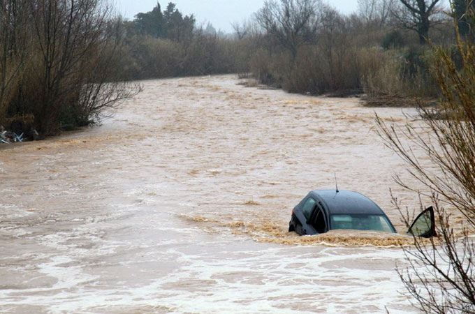
Stormy weather has lashed southwestern Europe with damaging winds and flooding rains causing widespread disruption.

Torrential downpours have brought flooding to parts of southern France that have killed at least 15 people. There are also 12 people still unaccounted for.

Just a week ago the weather across much of western Europe was cool, dry and settled, thanks to a large area of high pressure which was keeping Atlantic weather systems at bay. However, during the last few days the high has drifted east allowing milder weather to move in from the west.

As is usually the case at this time of year, milder weather also means wetter weather and this has certainly been the case on this occasion. Storms arrived here with a vengeance, initially moving across Portugal and Spain before spilling into the western side of the Mediterranean Sea.


O’Hare crosses the 9 inch threshold- 2012-13 snow season deficit almost eradicated

Posted on: March 5th, 2013 9:00 PM by Steve Kahn 

As of 9pm  the city's official snow total as measured at O'Hare International Airport reached 9.1 inches.  This brings the 2012-13 snow season total to 29.4 inches just slightly below the 31.1 inch normal total  through march 5 which is 95 percent of normal.


http://blog.chicagoweathercenter.com/severe-blog/

Saturday, February 16, 2013

Heavy rain swamps parts of Peru and Bolivia

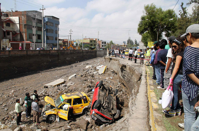
Flooding and landslides rip through roads and buildings, killing at least six people in Peru.


arts of Peru and Bolivia are struggling to recover after torrential rain triggered floods and landslides.

In Peru, the southern regions of Arequipa and Ica were the worst hit.

In Arequipa province, 120mm of rain fell in just seven hours on February 8. This amount of rain could cause flooding in almost any part of the world, but is particularly treacherous in Arequipa which is usually very dry. This is the wetter season, but the average rain for the entire month is only 36mm.
Authorities report that nearly 50,000 people have been affected by the extreme rain, and six people are known to have died.
A state of emergency has been declared in the flood-ravaged area after homes and cars were swept away by the floodwaters and over 20km of road destroyed.
Many residents have been left with nothing as rivers burst their banks, and washed away all their possessions. The rain also left several areas of the southern Peruvian region without power and phone lines.


Floods have affected about 48,000 people and left 4,000 houses damaged in Peru, according to local media 
[Reuters

http://www.aljazeera.com/news/americas/2013/02/201321493310715698.html