Showing posts with label Tuesday Ellison. Show all posts

Thursday, December 6, 2018

Alaska Putting Together Pieces After Massive Earthquake


ANCHORAGE, Alaska (AP) — The supply chain of food and other goods delivered to the Port of Anchorage from the Lower 48 has not been disrupted by the powerful earthquake that caused widespread damage to roads in the Anchorage area.

"The ships are coming in on schedule, the supply lines are at this point uninterrupted," Anchorage Mayor Ethan Berkowitz said Sunday at a news conference.

The magnitude 7.0 earthquake rattled the state's largest city early Friday morning swaying buildings and fraying nerves. There were no reports of deaths, serious injuries or structural damage to buildings.

Roads, however, took the brunt of the damage, especially the scenic Glenn Highway, the closest thing Alaska has to an interstate and links the state's largest city to suburban communities to the north.

Rare December Deadly Tornadoes Reported in Central U.S.


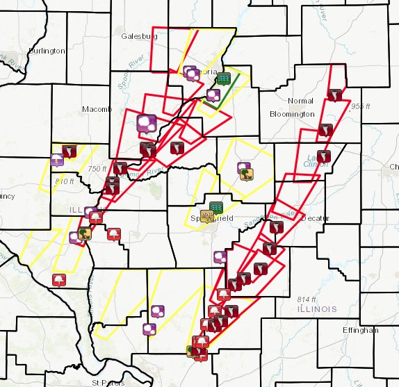
TAYLORVILLE, Ill. (AP) — Residents in central Illinois on Sunday assessed the damage after rare December tornadoes, including one the day before that was a half-mile-wide, ripped roofs off homes, downed power lines and injured at least 20 people.

The severe weather in Illinois was part of a line of thunderstorms that raked areas of the central U.S. late Friday and into Saturday, killing one person in Missouri. The National Weather Service confirmed tornadoes in Illinois, Missouri and Oklahoma.

At least three tornadoes were confirmed in northwest and southwest Arkansas, which largely caused property and structural damage. No injuries or fatalities were reported.

Peak months for tornadoes in much of the Midwest are April and June, according to the weather service. But at least 12 tornadoes were reported in Illinois on Saturday, including one in Taylorville which has been confirmed. If the majority are confirmed, that would be the most tornadoes in Illinois in a December storm since Dec. 18-19, 1957, when there were 21.

Residents Head Back into California Town Leveled by Wildfire


PARADISE, Calif. (AP) — Nearly four weeks after the devastating blaze leveled her town, Jennifer Christensen was allowed back to return to her home in Paradise, where the first thing she saw was her son's charred tricycle in the front yard.

Christensen was among hundreds of residents who were allowed back into neighborhoods on the east side of town for the first time since the Nov. 8 blaze, which killed at least 85 people and destroyed about 14,000 homes.

"It's unbelievable. You know, I never thought it would happen to me," said Christensen, 34, surveying how little was left. She had moved to Paradise about a year ago and lived with a couple that were like grandparents to her son. "Everything I worked so hard for is gone."

The first thing she saw as she pulled in was her 2-year-old son's tricycle, its tires melted and its steel frame charred. She found a safe with melted jewelry inside. She found remnants of porcelain dolls that her grandmother had given her every year for Christmas.

Heavy Rain, Wintry Mess Eyes Southern Plains, Mississippi Valley


After a rather quiet start to the work week, major trouble is brewing for the southern Plains for the second half of the work week.  This potent weather system then threatens the South and Southeast this weekend.

The weather system that is responsible for Wednesday's and today’s rainfall across California will slide into northern Mexico and then the southern Plains later today into Friday.  The combination of this upper-level energy and a water-logged air mass being pulled north from the western Gulf of Mexico will feed into a developing storm system across Texas.

Study Explains Creation of Deadly California 'Firenado'


REDDING, Calif. (AP) — A rare fire tornado that raged during this summer's deadly Carr Fire in Northern California was created by a combination of scorching weather, erratic winds and an ice-topped cloud that towered miles into the atmosphere, according to a study announced Wednesday. 
The churning funnel of smoke and flame killed a firefighter as it exploded in what already was a vast and devastating wildfire in July on the edge of Redding, about 250 miles (400 kilometers) north of San Francisco.
The wildfire claimed eight lives and destroyed more than 1,000 homes before it was contained on Aug. 30.

The study in the Geophysical Research Letters journal used satellite and radar data to suggest how a monstrous "firenado" the size of three football fields developed on July 26.

Global Carbon Pollution Up In 2018


WASHINGTON (AP) — After several years of little growth, global emissions of heat-trapping carbon dioxide experienced their largest jump in seven years, discouraging scientists.

World carbon dioxide emissions are estimated to have risen 2.7 percent from 2017 to 2018, according to three studies released Wednesday from the Global Carbon Project , an international scientific collaboration of academics, governments and industry that tracks greenhouse gas emissions. The calculations, announced during negotiations to put the 2015 Paris climate accord into effect, puts some of the landmark agreement’s goals nearly out of reach, scientists said.

“This is terrible news,” said Andrew Jones, co-director of Climate Interactive, which models greenhouse gas emissions and temperatures but was not part of the research. “Every year that we delay serious climate action, the Paris goals become more difficult to meet.”

Today's Weather Outlook


After a quiet midweek, the workweek’s second half will see a return of more active weather.

A Pacific rainmaker will move across southern California into the Southwest, bringing downpours to much of California. The rain and clouds will keep temperatures suppressed, with chilly 40s and 50s common in places used to 60s and 70s this time of the year. Across the Four Corners area and southern Utah, temperatures will be just cold enough for snow to fall in the highest elevations.

A weak front developing across the southern Plains will produce rain showers from southern and eastern Texas northward into the lower Mississippi Valley today. This will be the precursor to a deluge that will develop on Friday and early Saturday across the same area. Temperatures will be in the 40s and 50s, with 60s and a few 70s found across southern Texas. Snow will be possible over the Ohio Valley northeast into central Appalachians and eastern Great Lakes. Highs will be in the colder 30s and low 40s here.

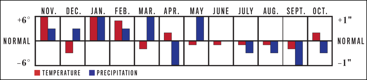
ANNUAL WEATHER SUMMARY NOVEMBER 2018 TO OCTOBER 2019


Winter will be warmer and rainier than normal, with near-normal snowfall. The coldest periods will be in mid- and late December, early and late January, and early February. The snowiest periods will be in early December, early and late January, early February, and mid-March. April and May will be slightly warmer than normal, with near-normal precipitation. Summer will be cooler and slightly drier than normal. The hottest periods will be in late May, late June, early July, and mid-August. September and October will be drier than normal, with near-normal temperatures.
Temperature and Precipitation Chart, November 2018 to October 2019 for Chicago, IL

Northeastern US to dodge blockbuster snow, ice storm set to slam southern US

While a storm with heavy snow and ice immobilizes part of the South, dry air is expected to win the battle in the Upper Midwest this weekend and the upper mid-Atlantic and New England early next week.
AccuWeather meteorologists expect the blockbuster snowstorm to slide eastward across southern Virginia and not make the northward crawl along the Atlantic coast.Static Storm Track Sunday Monday

Cosmic air burst may have caused cataclysmic destruction to Middle East 3,700 years ago

In an instant, those living in the ancient cities and agricultural settlements north of the Dead Sea were annihilated by a super-heated, cosmic blast from the skies that left destruction across nearly 200 square miles, according to new archaeological evidence.
During last month's annual American Schools of Oriental Research meeting, Phillip J. Silvia presented a paper showcasing soil evidence and analysis that suggests a meteor was responsible for the destruction of both the land and all human settlements in the region nearly 3,700 years ago.
According to the paper, the archaeological data collected demonstrates a pattern for a high-heat, explosive event. NASA Meteor
According to the researchers, a cosmic airburst due to a meteor at low altitude is the only natural force known that could have caused the unique, destructive characteristics found in both the region's soil, melted rock and many of the pottery samples collected at the site.
The event in the Middle East was so powerful that it, "not only [wiped] out 100 percent of the [cities] and towns," but also stripped the land of fertile agricultural soils and littered the landscape with super-heated brine from the Dead Sea in the subsequent shockwave, according to the paper's abstract.

Tips to use ice melt products properly and lower the risks they pose to pets, property

Salt and chloride products should always be used in combination with shoveling, snow blowing or plowing. The products are not made to melt three or four inches of snow, rather they should be used to melt ice or stubborn, packed-down snow.
By using too much ice melt product at a time, consumers run the risk of clumps of salt forming and remaining on the concrete or asphalt after the snow or ice has melted. These remaining salt clumps can cause damage to walkways, driveways and landscaping.
The ice melt can cause concrete and some asphalts to crack. The product can also have harmful effects on pets that tends to go outside.
“Using too much ice melt product is economically wasteful. Environmentally, you’re contributing more chlorides that will eventually reach freshwater sheds," explained Phill Sexton, a primary sustainability adviser at WIT Advisers. "Salt that is over saturated can have a reverse effect, it can actually cause concrete to freeze."Stand on top of the snow

Pair of windstorms to strike UK, Ireland from Friday into Sunday

Several days of stormy weather will unfold across Ireland and the United Kingdom in the coming days as multiple storms arrive from the Atlantic Ocean.
The potential exists for one of these storms to be named by the Met Office or Met Eireann. The next windstorm name on the list for this season is Deirdre, which will be followed by Erik.
A period of moderate to heavy rain will track from west to east across Ireland then the United Kingdom Thursday night into Friday morning.UK1 12/6
In the wake of the steady rain, blustery showers will continue to occur on Friday and Friday night.
While flooding is not expected to be a widespread concern, travel can be slow at times during the heaviest rain.
Local flooding will be possible in Wales, Southwest England and western Scotland where rainfall of 25-50 mm (1-2 inches) is expected by Friday night.
“Strong winds will also bring the risk of travel disruptions while raising the concern for tree damage, power outages and isolated damage to homes and businesses,” said AccuWeather Meteorologist Tyler Roys.
The wind will come in two waves, with the first striking Thursday night into Friday and the second from Saturday afternoon into Sunday morning.
UK Wind 12/6

Major winter storm eyes interior Southeast

While the storm will pack quite a punch in the South Central states this weekend, it may hit like a sledge hammer over portions of the Southeast states from Saturday night to Monday.
"In areas from central and western North Carolina to parts of southern West Virginia and southwestern and south-central Virginia, this will be a major storm with the potential for a foot or more of snow," according to AccuWeather Senior Meteorologist Brian Wimer.Static Snowfall Map SE 10 am
A wintry mix is in store in areas from northeastern Georgia and easternmost Tennessee to part of the South Carolina midlands, a portion of eastern North Carolina, much of southeastern Virginia and southern portions of the Delmarva peninsula.Static SE Snow and Ice Storm

Immobilizing storm to bury Carolina's, southern Virginia in snow and ice

A cross-country storm will crawl through the southern United States with a swath of debilitating snow, damaging ice and flooding rain into early next week.
Rain, thunderstorms and a wintry mix are scheduled to slowly overspread the southeastern U.S. on Saturday.Sat storm 12.6 AM

LOCAL NEWS 911 outages plaguing Southeast


The North Carolina 911 Board has notified emergency communications centers across the region about problems with 911 service.
"We have received notice from multiple carriers there are issues with 911 service – wireline and wireless – across the entire Southeast portion of the country," the board said in a statement. "Carriers are addressing the issues at their respective levels and working toward a resolution."


Storm to sweep through southern US with flooding, severe weather Friday to Sunday

A multifaceted storm will unleash flooding rainfall and localized severe weather across the southern tier of the United States beginning on Friday.
While the Deep South will escape the snowy, icy side of the storm, disruptions due to rain and flooding are likely along the Interstate 10 and I-20 corridors.
Airline passengers at the major hubs of Dallas, Houston, New Orleans and Atlanta can face significant delays. Ripple-effect delays can spread elsewhere across the country.
Very heavy rainfall and flooding will be a big threat with this storm, according to AccuWeather Meteorologist Ryan Adamson. Fri-Fri night storm snapshot 12.6 AM

Monday, December 3, 2018

Tornadoes knockout power in Macon County

The tornadoes snapped trees and power lines, and shifted one house off its foundation in Macon County.
Around 10,000 customers were without power in the state on Saturday night. This number dropped to below 2,000 on Sunday. IL Tornado
A funnel cloud is spotted in Beardstown, Illinois, on Saturday. (Photo/Blake Naftel)

Photos: Severe storms generate tornadoes from Illinois to southeast Georgia this weekend

A series of tornadoes stirred up damage from the Plains to southeast Georgia over the weekend.
A swarm of tornadoes rocked central Illinois on Saturday, making it one of the most violent December days in the state’s history.
There were over 20 preliminary tornado reports, according to the National Weather Service Storm Prediction Center.
“The actual number of confirmed tornadoes will be determined by storm surveys over the coming days,” AccuWeather Meteorologist Brett Rathbun said.

Weekend Forecast is Cold and Snowy


“Some snow showers are expected from the Great Lakes into the Northeast with this cold front from Thursday to Friday,” AccuWeather Lead Long-Range Meteorologist Paul Pastelok said.
Snow could come close to St. Louis and may coat Chicago, Indianapolis and Detroit on Thursday, before reaching Pittsburgh and Syracuse, New York, late in the day or at night.
Locally heavier snow squalls are possible along this corridor.
Frigid air will settle in behind the front, with highs likely being held in the teens in Minneapolis and 20s in Chicago to end the week.
While the air will not be quite as cold when it reaches the Northeast, highs several degrees below normal will remain common at late week.
AccuWeather meteorologists are monitoring a storm that may tap into this cold air, spreading a swath of snow and a wintry mix from the central and southern Plains to part of the Eastern Seaboard late this week and into the weekend.25StormTrack

Cold Midwest

Temperatures will plummet throughout the day on Monday for the eastern Great Lakes and northern New England. Temperatures will fall even further on Tuesday, with high temperatures in the 20s F across upstate New York and New England and 30s over the rest of the interior.
Tuesday’s highs may be 20 to 30 degrees lower than Sunday’s peak temperatures across the interior Northeast.
People along the Interstate-95 corridor from Washington, D.C., to Boston can keep the winter coats in the closet until Tuesday, when cooler air will reach the coast.
Download the free AccuWeather app to see when and how much temperatures will plummet in your area.
A reinforcing shot of cold air will sweep through the Midwest and Northeast during the latter half of the week.Cold dominates 12.2 AM