Showing posts with label Yesenia Jimenez. Show all posts

Tuesday, April 30, 2013

May Kicks Off With Snow and Cold


This spring has been especially frustrating for those itching to leave Ol' Man Winter behind.
Here we are flipping the calendar to May and we still can't remove the "S" word from our vocabulary just yet. That's right, more snow is headed for the central United States on the heels of what was a very wintry April.
(APRIL SNOWSTORMS: Walda | Xerxes | Yogi | Zeus)
Background

Highs Wednesday

Highs Wednesday
Thanks to bullish, blocking high pressure aloft over the eastern Great Lakes northward into Labrador (eastern Canada), a dip in the jet stream, or trough, will dig into the nation's heartland, then get blocked and end up closing off into a vigorous, nearly-stationary closed low.
The first effect of this will be a return of stubborn, chilly air to the Plains.
Mid-to-late-week highs in the 40s, possibly even 30s in some spots, can be expected in parts of the Plains and Midwest, not to mention the Front Range of the Rockies. 
(HIGHS: Wed. | Thu. | Fri. | Sat.)
That fresh cold air will set the stage for what will be a snowy couple of days from the Front Range of the Rockies to parts of the Plains and Midwest.

More Rockies, Midwest Snow Ahead

Background

Tracking The Storm

Tracking The Storm
Background

Snow Forecast

Snow Forecast
Background

Tracking The Storm

Tracking The Storm
Background

Tracking The Storm

Tracking The Storm
  • Rockies Snow - Denver, Colo. andCheyenne, Wyo. are a couple of the cities that will see snow with a cold front diving southTuesday night into Wednesday. Amounts could top a foot in portions of Wyoming! Parts of the Denver metro area could pick up 6 inches or more. This comes after an April where snowfall was 20 inches above average in Cheyenne and 11 inches above average in Denver.
  • Plains, Midwest Snow Too? - Wednesday night through Thursday, portions of the Plains and Upper Midwest near the closed upper-low could see some wet snow. Parts of Minnesota, western Wisconsin, Iowa and Nebraska seem most likely to see this, but flakes could also fly in Kansas, and even Missouri, where accumulating snow is extremely rare in May. Our most reliable computer models are even putting northern Oklahoma in play for some light snow - stay tuned! Minneapolis,Rochester, Minn.Sioux City, Iowa andOmaha, Neb. are a few of the cities we'll be watching Wednesday night through Thursday for this snow potential.
  • Heavy Rain Threat -  Lastly, ahead of this closed low, an expansive band of heavy rainfall may set up from the Deep South into the Midwest. Water-logged parts of Missouri and Illinois will need to pay special attention to this possibility.
This is a very complicated forecast scenario. Therefore, exact forecast details are still highly uncertain, so check back with us as we refine this forecast.
Suffice to say, this will be a rather wild weather pattern for early May.

Windswept Rain to Swing Through Boston Overnight


Update: 8:45 p.m. EDT Friday: The manhunt for the second suspect in the Boston Marathon Bombings has ended. Rain is expected to continue falling over Boston and its suburbs through 7:00 a.m. Saturday, as police continue their investigation.
A period of rain, accompanied by gusty winds, will sweep from west to east across New England and the Boston area overnight, where the manhunt is ongoing for the remaining suspect in Monday's Boston Marathon bombings.
On Friday, police were focusing the search in the western suburb of Boston, known as Watertown.
Officials work a crime scene in Watertown, Mass., Friday, April 19, 2013. Multiple police officers and National Guard members are in the community, where television outlets report that gunfire and explosions have been heard. (AP Photo/Julio Cortez)
The timing of the rain squall, that can be accompanied by thunder and lightning, in Boston and its suburbs is between midnight and 6:00 a.m. EDT Saturday.
Downpours during the early morning hours Saturday could hamper the search in the area by bringing low visibility, brief urban flooding in some neighborhoods and raising the risk of hydroplaning for vehicles traveling at high speed.
There is an outside chance of a locally severe thunderstorm overnight that could bring damaging wind gusts and sporadic power outages.
A shower will also visit some areas of New England prior to the main swath of rain.
The balance of the weekend will feature dry and much cooler weather. Blustery conditions are in store Saturday with clearing. Less wind is in store for Sunday.

Flooding In Illinois


Additional rain fell on flooded areas of the Midwest this week. However, there is hope that the rain will not make situation worse.
A storm bringing snow to part of the northern Plains, Rockies and upper Great Lakes during the first part of this week sent a swath of rain through the Midwest.
As expected this system was less intense and faster-moving, when compared to last week's storm that pushed rivers to moderate, major and record flood stage.
Members of the Missouri Nationals Guard and others work to shore up a temporary levee in an effort to hold back the swollen Mississippi River Saturday, April 20, 2013, in Clarksville, Mo. Communities along the Mississippi River and other rain-engorged waterways are waging feverish bids to hold back floodwaters. (AP Photo/Jeff Roberson)
Last week, portions of states from Missouri to Illinois, Iowa, Indiana, Michigan and Wisconsin received from 3 to 7 inches of rain. Much of that rain fell during a 24- to 36-hour period upon saturated ground.
As of 10:00 a.m. CDT Wednesday, April 24, 2013, the rainfall from the recent storm system has ranged from 0.50 to 1.50 inches with a few spots picking up a bit more from Missouri and Iowa to Michigan, Illinois and Indiana.
The rainfall is likely to slow the recession of river levels and could cause minor rises at some locations a short time after the rain as it flows into progressively larger rivers.
Moving forward there are indications of additional rainfall events.
The speed, intensity and location of the heaviest rainfall with these systems will be monitored for the risk of stream and river flooding over the Midwest.
There is concern of major flooding along the Red River of the North which borders North Dakota and Minnesota. While rains are avoiding this basin, extensive snow cover remains, which contains a great deal of water. A rapid thaw this weekend will initiate a rapid rise on the river and may culminate into major flooding next week.
The National Weather Service issues official flood statements and river level forecasts based on their own rainfall projections, snow cover and hydrological and geographical algorithms.
Dozens of barges broke free along the Mississippi River this weekend from St. Louis, Mo., to Vicksburg, Miss. Increasing flow and rising water levels on the river were partially to blame.
Some of the barges have sunk and several near St. Louis drifted downstream and struck the Jefferson Barracks Bridge. While the bridge was closed for a time over the weekend, it has since been inspected and reopened. Most of the barges have been recovered or secured as of Monday.

Winter's Last Gasp: April Yields Snow, Cold Records


A series of April snowstorms has caused many records to fall and extreme temperature swings from Colorado to Minnesota. The latest storm to impact the Plains early this week appears to be the caboose of the storm train with the weather pattern expected to ease.
"There are no more major cold outbreaks in the pipeline," AccuWeather Expert Senior Meteorologist Jim Andrews said. "So, it looks like the end of record-breaking April snowfall and also the extreme temperature swings over the Plains, where it is nearly summery on one day and downright wintry on the next day."
It is still cold in western Canada, and cooler air may still be unleashed over the northern Plains at times into May, according to AccuWeather Lead Long-Range Forecaster Paul Pastelok. However, the temperature swings that occur into May will be more typical of spring compared to the recent extremes.
One sign of the changing pattern is the threat of major flooding along Red River of the northern U.S. as surging warmth this weekend threatens to melt unusually deep late-season snowpack.
"Well, spring in here on the calendar, whether it has been in reality or not. You can only hold back reality for so long. And that reality is that daytime temperatures should be well above freezing in North Dakota and Minnesota. We have held back reality with repeated rounds of cold. The sudden return of reality [this weekend] means that the snow is going to disappear very fast," Andrews said.
"By the end of the week, the normal high in Fargo is 64 degrees, so if it reaches 70 it's not that unusual," Andrews said.
Statistics on the Cold and Snow in the Plains April 2013
A total of 995 daily snowfall records have been broken during the month so far as of April 22, 2013, according to the National Climatic Data Center (NCDC). As a comparison, last year during the same timeframe, 195 snowfall records had been broken.
According to NOAA, 91.9 percent of the Upper Midwest is covered by snow currently, whereas only 0.4 percent of the Upper Midwest was covered by snow on April 23, 2012.
The map above (from the National Operational Hydrologic Remote Sensing Center) shows that 91.9 percent of the Upper Midwest is covered by snow on April 23, 2013.
Duluth, Minn., had a record daily snowfall of 8.2 inches on Monday. The old record of 7.8 inches was set in 1972.
April Snow Statistics:

The latest storm in Duluth has allowed April to go down in the record books as the snowiest month ever with a total 51.0 inches. Previously, the snowiest month on record for Duluth was November 1991 when 50.1 inches fell.

A record April snowfall has been recorded at Pierre, S.D., with 20.8 inches so far this month. The old record April snowfall was 17.5 inches set in 1986.

Rapid City, S.D., has received a total of 43.4 inches of snow so far in April. That is more snow than the city typically receives during the entire season, which is 41.4 inches.
Snow and cold made it all the way down into Texas on Tuesday morning.
Childress, Texas, had a high of 92 degrees on Monday before temperatures plunged into the 30s overnight with snow arriving.

Santiago, Chile, May See First Rain of 2013


Prospects for rain appear slim for residents of Santiago, Chile in the coming days. However, a storm system may bring the first rain of the season to the area this coming Thursday and Friday.
Largely dry conditions prevail across central Chile during the Southern Hemisphere's summer months. It is late in the fall, into the winter, that rainfall becomes more abundant throughout central Chile as the jet stream shifts storms closer to the region.
One such storm passed just south of Santiago late this past week. While a cold front did cross the region, bringing cooler weather to the area, no rain was reported.
The next chance for some rain will come later this week when another storm passes near the region, dragging a cold front toward the area next Thursday and Friday.
However, this storm may still pass far enough south of Santiago to prevent any moisture from reaching the city. If that were the case, residents of Santiago may have to wait another week or more before the chance for rain increases once again.
Santiago typically averages 14.20 inches (360.7 mm) of rainfall during the year. Most of the rain falls during the months of May through September, the Southern Hemisphere's winter.


Severe Storms into Tonight For Laredo, Little Rock, Memphis


A storm system will tap in to a warm and moist airmass over the southern Plains, helping to spark a round of severe thunderstorms into tonight.
This is the same storm which will also lead to locally flooding rains over parts of the Southeast the rest of this weekend.
Thunderstorms will fire this afternoon in two primary zones. The first one being over south-central Texas from west of San Antonio through Del Rio and Laredo.
These storms will initially fire over the higher elevations in northern Mexico before tracking into Texas.
These south-central Texas storms will initially be capable of producing large, damaging hail and damaging wind gusts greater than 65 mph.
Farther to the north and east, thunderstorms will develop along a trailing cold front this afternoon from far northeast Texas through western Tennessee.
This will bring a threat for damaging winds and large hail to Little Rock, Memphis, Tuscaloosa, and Shreveport.
Though the graphic above shows two distinct regions where the best chance for severe weather lies, there can also be an isolated gusty thunderstorm in between these zones across central Texas. San Antonio, Austin, Waco, and Houston lie in this zone where very isolated thunderstorms may fire.
There is even the threat for an isolated tornado or two, especially from eastern Arkansas into northern Mississippi and southwestern Tennessee where the best "wind shear" is occurring.
Wind shear is a term which means "twisting of the winds as you go higher in the atmosphere." The more wind shear or the more changing of the winds, the better chance for rotation in thunderstorms.
Stay tuned to AccuWeather.com into tonight as we continue to monitor the severe weather threat.
Heed all watches and warnings and check in with our Severe Weather Center for the latest information.

Severe Storm Risk Kansas to Wisconsin Tuesday


There is the potential for locally damaging thunderstorms through Tuesday from portions of Kansas to part of southern Wisconsin.
Cities that can be hit by one or more thunderstorms and the potential for severe weather include Dodge City and Russell, Kan., Kansas City and St. Joseph, Mo., Des Moines and Cedar Rapids, Iowa, La Crosse and Madison, Wis.
The greatest threats from the storms throughout the region are damaging wind gusts, large hail, flash and urban flooding and frequent lightning strikes.
Where the storms repeat, there is an elevated risk of flooding. A couple of the strongest storms can also produce a tornado.
The storms are firing along a developing push of colder air that will sweep southward to Texas this week but will only crawl eastward.
As a result, portions of central and northern Kansas to northwestern Missouri, southeastern Nebraska, Iowa and southern Wisconsin will be under the risk from severe storms through Tuesday.
The bulk of the rain through Tuesday will fall north of the Illinois River and south of the Red River of the North, two rivers which have been hit by flooding recently.

Severe Storm Threat Shifts to Midwest


The threat of a few severe thunderstorms will focus on the central states Tuesday into Wednesday.
(ON THE WEATHER CHANNEL: Tornado Week 2013)
Background

Monday's Forecast

Monday's Forecast
Background

Wednesday's Forecast

Wednesday's Forecast
Tuesday's area of concern will be ahead of a cold front in a narrow zone from central Wisconsin southwestward to northeast Kansas. Wednesday, our eyes will be focused on the southern end of this front from parts of southeast Kansas and central Oklahoma into Texas.
Damaging winds and large hail will be the main threats each day. That said, we cannot completely rule out the chance of a tornado or two.
At this time, we are not expecting a widespread outbreak of severe weather.
We have all the maps you need to track severe weather below, watches and warnings, and radar.
We also have links to see what your typical climatological tornado risk is, as well as links to our iWitness photo/video galleries and our Notify! severe alerts service.

National Weather Service confirms tornado touch down in Bainbridge


PhotoCHENANGO COUNTY (AP) -- The National Weather Service confirms that a tornado touched down in southern Chenango County when a strong cold front swept across the region Friday night.
The agency says the tornado landed around 8 p.m. Friday in the town of Bainbridge and traveled 3.2 miles northeast, ending near Sidney in Delaware County. The tornado lasted about five minutes and had a maximum wind speed of 110 mph.
No injuries were reported. There was some property damage from the tornado and accompanying storm, including uprooted trees, damaged roofs and power outages.

Bone Dry Florida Turns Stormy and Wet


As a slow-moving disturbance works its way along the Gulf Coast, showers and thunderstorms will bring much-needed rain across Florida through the weekend.
On Tuesday and Wednesday, the showers and thunderstorms will have the greatest concentration across southern Louisiana, southern Alabama and southern Mississippi. Areas from Lake Charles eastward to New Orleans and Mobile could have as much as 1.00-2.00 inches, and some flooding is even possible in the heaviest activity.
On Thursday through Sunday, the heaviest showers and thunderstorms will shift into the state of Florida.
Rainfall amounts will average 2.00-4.00 inches across much of the peninsula, with lesser amounts of 1.00-2.00 inches across the western panhandle.
Showers and thunderstorms will feed off a tropical atmosphere, and resulting blinding downpours will cause localized flash flooding.
Some of the areas with the greatest potential for heavy rain include Jacksonville, Orlando, Daytona Beach and Melbourne.
Flooding of low-lying areas and small creeks and streams will be the biggest threats from these storms, as they respond the quickest to rapid water runoff from thunderstorms.
The showers and thunderstorms will also have an impact on those who will be on vacation or have outdoor activities planned.
If you plan to be out and about this week, keep a close eye to the sky. Remember, if you can hear thunder, you are close enough to the storm to be struck by lightning. This is especially relevant when golfing or swimming, as you become particularly vulnerable.
Torrents of rain can also slow travel significantly as visibility is reduced and roadways become slick.
The rain and thunderstorms are not all bad for residents across the state, however.
Many areas, especially across central Florida from Tampa to Ocala and Jacksonville have been under moderate to severe drought conditions for much of the winter and early spring.
As many as two dozen wildfires were burning around the state as of early Tuesday morning.
.
These fires are not just occurring in rural areas, either. According to the Associated Press, last week a brush fire spread rapidly and came dangerously close to an apartment complex near Orlando.
Smoke from these fires can also reduce and lead to dangerous travel on major interstates that run across the region, such as 95, 75 or 4.
Smoke can also cause breathing problems for those with asthma or other respiratory related illnesses.
The expected rainfall over the next week will not only help to douse the flames, but also wet the lips of thirsty creeks, streams and plants that have had very little to drink over the past six months.


Read more: http://www.foxnews.com/weather/2013/04/29/bone-dry-florida-turns-stormy-and-wet/#ixzz2Rxub2mrt

New Flooding Concerns for the Midwest Later This Week


More rain is in the forecast for later this week in parts of the Midwest that have been hit by flooding recently.
A slow-moving storm will take shape over the Plains during the second half of the week. The circulation around that storm will draw some moisture northward from the Gulf of Mexico.
States at risk for enough rain to cause flash and urban flooding problems spanning Wednesday to Saturday include Missouri, Illinois, Iowa, Wisconsin, Michigan, Arkansas and Tennessee.
While part of the region has had a few days of rain-free weather, enough rain could fall over a several-day stretch to bring renewed poor drainage area and small stream flooding. There is also the potential for new rises on rivers that have crested or are receding during the first part of this week, including the Illinois, Wabash and upper Mississippi rivers.
Most of the rain later this week is projected to fall south of the Red River of the North Basin. However, flooding from melting snow has already set that river on a path for moderate to major flooding.
Most stream and river systems in the area would be able to handle between 2 and 4 inches of rain spread over as many days. However, there is the potential for this sort of rainfall in less than half this time in some locations.
Snowstorm Potential: If all the right pieces were to fall into place, some communities over the central Plains that rarely get a foot of snow from a storm in January may be digging out from a foot of snow by the end of the week.
While such a storm is more common in Denver and the High Plains, such an event is increasingly more rare farther east and over lower elevations in the region. The storm would be hitting some areas from eastern Nebraska to northwestern Iowa, southeastern Minnesota and northwestern Wisconsin on May 2 and 3.
AccuWeather.com will continue to provide updates on the snowstorm, the return of cold air to the Plains and any severe weather and flooding consequences farther east in the Central states.
Details will follow as the week progresses.


Read more: http://www.foxnews.com/weather/2013/04/30/new-flooding-concerns-for-midwest-later-this-week/#ixzz2RxuA8IJf

Tropical Cyclone Zane Aims for Australia


Tropical Cyclone Zane formed in the Coral Sea to the northeast of Queensland on Monday and quickly strengthened during the next 24 hours.
Zane currently has tropical storm-force sustained winds but is expected to strengthen further as it approaches the Cape York Peninsula of Queensland Tuesday night into Wednesday.
Winds could reach the equivalent of a Category 2 hurricane before landfall with maximum winds approaching 100 mph (160 kph).
Landfall is expected across the northern half of the Cape York Peninsula, Wednesday night, local time. The main threats will be damaging winds at and near the coast along with flooding rains which can cut some of the small towns of the region off for several days.
The satellite image above shows Zane off the coast of Queensland Tuesday night, local time.
Zane is expected to remain a tropical cyclone, although in a weaker state as it moves farther west into the Gulf of Carpentaria later in the week.
At this point, it appears Zane will likely lose its tropical cyclone status before making another landfall, but enhanced rainfall could lead to some flooding potential across northern third of Northern Territory late in the week.


Read more: http://www.foxnews.com/weather/2013/04/30/tropical-cyclone-zane-aims-for-australia/#ixzz2RxtgzjNx

Monday, April 29, 2013

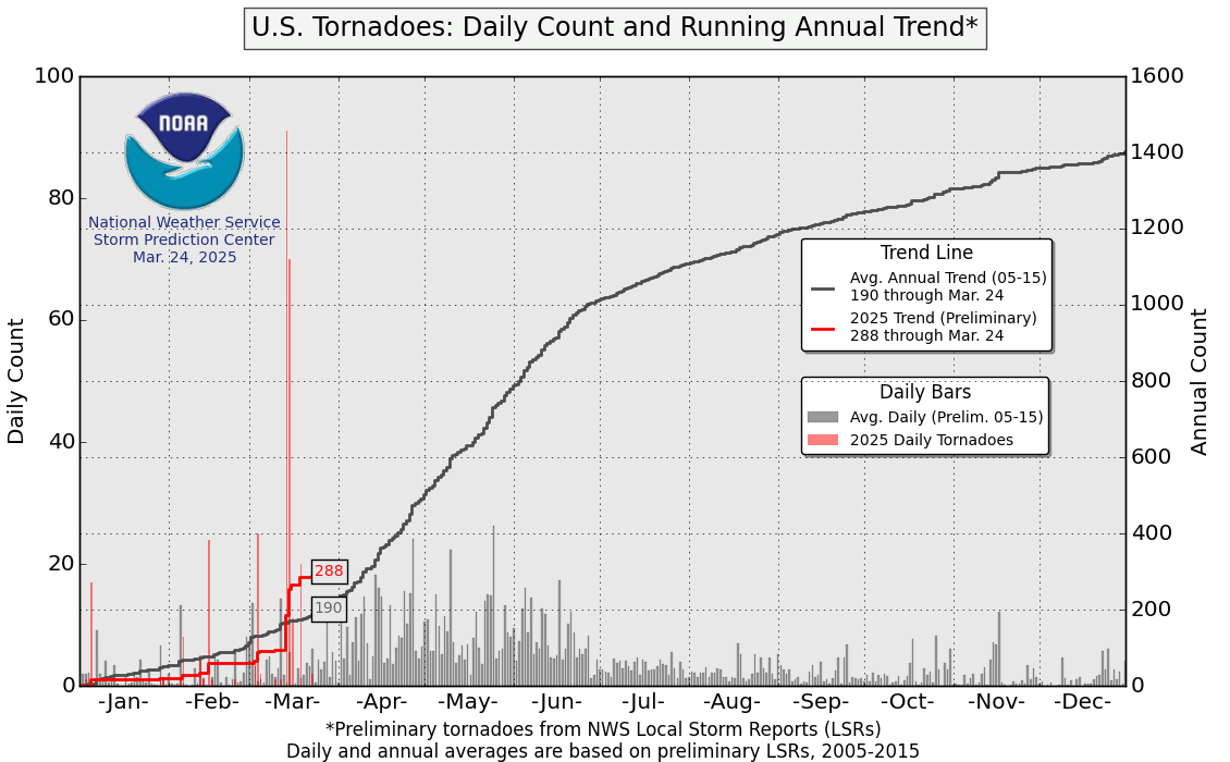
Unusual Start to Tornado Season


Tornado season has been off to a slow start compared to the amped-up season last year.
The daily count and running annual trend of tornadoes in the United States has been significantly lower this season compared to last. According to NOAA, there were 592 tornadoes between Jan. 1 and April 25. This season during the same period, the U.S. has only endured 226 tornadoes. The average is 492.
AccuWeather.com Expert Senior Meteorologist Henry Margusity said that there has been a decrease in tornadoes this year compared to last.
"The tornado season is below normal in regards to tornadoes since May 2012," Margusity said.
Last year, tornadoes were active during the first half of the season from Jan. 1 through April 25. The decrease in tornadoes this season can be attributed to a much colder weather pattern, according to Margusity.
"Last year we had gangbusters to start out the year, and this year we haven't had any," he said.
Warmer weather has been delayed this season compared to last. Cold dry air has been reached farther south.
"Last January was very warm. As the warmth continued, there were more outbreaks," he said.
AccuWeather.com Expert Senior Meteorologist Dan Kottlowski said the cold pattern that has occupied the United States is due to a major change in the upper levels of the atmosphere above the Arctic Circle. A pattern change that occurred in February allowed cold air from Canada to dip down into southern states. This pattern occupied much of the U.S. into April.
With cold air sticking around for a longer period of time, conditions were not favorable for tornado formation, Margusity said.
Harold Brooks, senior scientist at the National Severe Storms Laboratory in Oklahoma, also agrees that cold weather has a played a significant role in deterring tornadoes from forming.
"Final counts in March will be close to the lowest mark on record," he said.
This tornado season is below normal, and Brooks said it is in the lower 10 percent of tornado activity over the past 60 years.
The reason that we witnessed more tornadoes last year is because January through March was very warm compared to this year.
This year, cold fronts moving into the Gulf of Mexico have spread dry air across the Southern states, according to Margusity. Due to the cold, dry air that was dipping so far south, sea temperatures in the Gulf of Mexico were not that warm yet. With sea temperatures not rising as fast as last year and a colder weather pattern in place, humid, moist air from the Gulf, a necessity for tornado development, has not been available. However, Kottlowski said temperatures are starting to rise.
With cold air lasting into the latter part of spring and the lack of deep tropical moisture, this has contributed to the lack of tornado formation.
"The atmosphere is not unstable," Kottlowski said.
Margusity said that this is just a weather pattern we are in. Weather conditions are not favorable for producing tornadoes. The tornado season in 2004 was similar to this one; however, Margusity pointed out that we are not in a La Nina or El Nino that would be driving this colder weather pattern.
However, AccuWeather meteorologists think that the months of May and June could be active when it comes to tornadoes.
"Our fear is that there will be more severe weather in June," Kottlowski said.
According to Kottlowski, severe weather will occur in May, but a better question to ask is how frequently tornadoes will occur.
Brooks said that even though we got off to a slow start, there is no way to really tell what the rest of the season will be like.
"This means nothing for May. Anything that happens between Jan. 1 to April virtually tells us nothing about how the rest of the season will be," he said.
As far as predicting when and where tornadoes will form, meteorologists are still researching.
Predicting exactly where a tornado will strike is hard to do because tornadoes are unpredictable. However, Margusity said that eventually meteorologists will be able to predict 6-12 hours in advance which areas are likely to have tornadoes and the severity.
Brooks also expressed the challenge of predicting tornadoes and hopes that by 10 years we will have more technology to predict when and where tornadoes will occur.
"Maybe 10 years, between five and 10 years from now depending on time of year and what type of system we are looking for. It is a hard research problem," he said.
The decline in tornadoes compared to last year is not a bad thing.
Margusity said that with a lack of tornadoes, there is no massive destruction, and people are not getting hurt or killed from severe weather.
For all of your up-to-date and local severe weather, be sure to check out AccuWeather.com Severe Weather Center.

Less Rainfall Expected for the Hawaiian Islands


Apr. 22, 2013 — Almost imperceptibly, rainfall over the Hawaiian Islands has been declining since 1978, and this trend is likely to continue with global warming through the end of this century, according to a team of scientists at the University of Hawaii at Manoa (UHM) and the University of Colorado at Boulder. This latest Hawaii rainfall study, published in the March 13, 2013, early online issue of the Journal of Geophysical Research, supports previous work conducted at the University of Hawaii. What has been unclear, however, is whether this drying trend will continue.
"


For water resource and ecosystem management, and for other societal needs, we need to know whether this drying trend will continue this century," says lead investigator Oliver Elison Timm at the International Pacific Research Center, UHM.
As of now, not even cutting edge climate models have enough resolution to capture the diverse rainfall pattern over Hawaii, where dry and wet areas often lie only a mile or even less apart.
To work around this problem, the team devised a method called 'statistical downscaling.' They first got a take on the effects of the general drying trend on local heavy-rain days by reanalyzing observations from 1978 to 2010 at 12 rain-gauge stations spread throughout the islands. Studying hundreds of weather patterns during such days, they identified the typical atmospheric circulation patterns in the North Pacific that favor heavy rains over Hawaii.
"The patterns we saw did not surprise us," recalls Elison Timm. "For example, we found that the typical winter Kona storms with moist air-flow from the South often produce torrential rains in the islands."
Using those weather patterns linked to heavy rains, the team developed a statistical model that estimates the number of heavy rain events during a year. They found that the large circulation patterns over the mid-latitude and tropical North Pacific have already shifted since 1978 so that fewer weather disturbances reach the Islands during the rainy season from November through April.
"We can't predict individual rain events with our method," clarifies Professor Thomas W. Giambelluca, Department of Geography, UHM, "but it gives us a very good estimate of the number of heavy rain events in a given season based on the large-scale atmospheric circulation patterns."
Combining information from their statistical model and cutting-edge climate models driven with the projected increase in greenhouse gases until the end of this century, the scientists conclude that we can expect the recent trend towards drier winter seasons with fewer heavy-rain days to continue through the end of this century.
"It is extremely difficult to take all the uncertainties into account and our overall result may not apply to all sites in Hawai'i," cautions Senior Researcher Henry Diaz from the University of Colorado. "We are just beginning to understand the details of how climate change will affect the Hawaiian Islands. We do not know yet how further warming will impact extreme heavy downpours."

Houston Weekend Storm and U.S. Record Point Rainfalls


Published: 7:58 PM GMT on April 29, 2013

Last Saturday evening (April 27th) the Houston area was swamped by as much as 8” of rain, most of which fell in just a couple of hours. The city’s official weather site at Houston’s Hobby Airport measured 3.07” in one hour with an amazing 0.69” of this falling in one 3-minute period according to the site’s METAR reports. Also in this blog is a table of record point U.S. rainfalls for various periods of time.

The Houston storm

A slow moving group of thunderstorms accompanied by torrential rain and hail drifted over the greater Houston area late Saturday afternoon and evening. Rainfall was heaviest in the southwestern section of the city where a maximum accumulation of 8.12” was reported at a MESONET site in Sugarland-Meadows Place. As one can see on the map below, the heavy precipitation was confined to a relatively small area but included most of Houston’s downtown core, but with little rain falling over the northern suburbs.


Storm totals for the April 27-28 event in the Houston area. Hobby Airport on the south side of town picked up 6.31” whereas Houston International Airport, on the north side of town, received only a 0.26” total. Most of the storm rainfall fell in the two-hour period of 5-7:p.m on April 27th. Map from NWS-Houston.

The storm reached its peak intensity over Hobby Airport between 5:00 and 6:00 p.m. on Saturday evening. The following amounts of rainfall were reported at the site during the time frames mentioned:

0.69” in 3 minutes (5:26-5:29 p.m.)

1.21” in 7 minutes (5:22-5:29 p.m.)

2.18” in 19 minutes (5:22-5:41 p.m.)

2.77” in 34 minutes (5:07-5:41 p.m.)

3.07” in 1 hour (4:53-5:53 p.m.)


Severe Storm Threat Shifts to Midwest


The threat of a few severe thunderstorms shifts to the Midwest as we start the week on Monday and Tuesday.
(ON THE WEATHER CHANNEL: Tornado Week 2013)
Background

Monday's Forecast

Monday's Forecast
Background

Monday's Forecast

Monday's Forecast
Damaging winds and large hail will be the main threats each day from parts of southern Wisconsin southwestward to northern Missouri and far northeast Kansas. That said, we cannot completely rule out the chance of a tornado or two in this region.
(CITIES: Des Moines | Madison | Quad Cities)
At this time, we are not expecting a widespread outbreak of severe weather.
We have all the maps you need to track severe weather below, watches and warnings, and radar.
We also have links to see what your typical climatological tornado risk is, as well as links to our iWitness photo/video galleries and our Notify! severe alerts service.

Background

Severe Alerts

Severe Alerts

Active Watches and Warnings

See the latest watches and warnings across the nation using our clickable severe weather alerts map.
Regional alert zooms:  

Background

Current Radar

Current Radar

Track the Storms in Your Area

Track the severe thunderstorms using ourinteractive radar map
You can also see how much rain has fallen by clicking on the 24-hour rainfall interactive map.


TOR:CON

Severe Weather Expert, Dr. Greg Forbes, rates your tornado risk today on a scale of 1 to 10.  Find out if there's a heightened risk where you live.

Typical Tornado Risk

Severe Weather Expert Dr. Greg Forbes shows you what time of year and in what locations the tornado risk peaks.  Click on the links below to learn more about tornado climatology.

iWitnessWeather Photos/Video

If you crave pictures of severe weather, you've found your home here.  
- Galleries:  Tornadoes | Hail | Lightning
Upload your photos or video to us and share your experience!

Storm Tracker App

Watch live storms and make notes directly on the maps with the new Intellicast App for iPad. Upgrade to the subscription app and see high resolution sweeping NEXRAD and TDWR radar, lightning plotting, and EWSD storm tracking, all in an ad-free environment.
Find out more here.