Showing posts with label Zach Doud. Show all posts

Wednesday, November 19, 2014

At Least 7 Dead From Lake Effect Snow; State of Emergency Declared

At Least 7 Dead From Lake Effect Snow; State of Emergency Declared

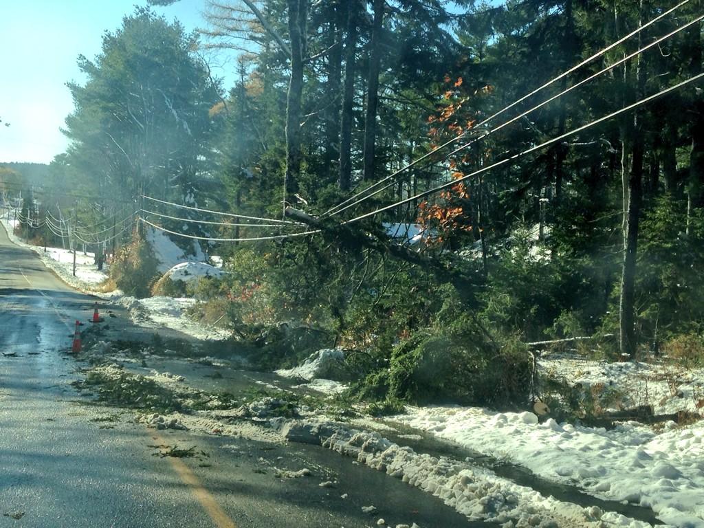
Snow was still falling on the Buffalo, New York, area Wednesday morning, a day after a major lake-effect snow event dumped more than 60 inches of snow on areas south of Buffalo, killing at least seven people and stranding others in vehicles for more than 30 hours, in some cases, on roads throughout the area. 
Snow also fell in other Great Lake states, including northern Wisconsin and the Upper Peninsula of Michigan, where up to two feet of snow blew ashore. Those areas will get a bit of a reprieve today before the lake-effect event ramps-up again in the evening hours Wednesday into the morning Thursday. For specific forecast details click on the link below.
At least seven storm-related deaths were reported in the Buffalo, New York area, authorities announced.  A 46-year-old man was found dead in his vehicle in Alden, New York. The car was completely buried in snow, The Buffalo News reports. 
A 30-year-old Pennsylvanian man died in Cheektowaga, New York, when a high lift attempting to free a vehicle stuck in snowaccidentally pinned the man to the car, killing him, according to the Cheektowaga Police Department. 
Five additional deaths were reportedly due to cardiac complications. 
“If people have underlying heart disease, even if it’s well controlled with medication, or high blood pressure, please don’t go outside and shovel the driveway, ” Erie County Health Commissioner Dr. Gale Burstein told WIVB. “The additional stress on your heart, of being outside in the cold, in addition to shoveling that heavy snow, and it is heavy, can cause people to have heart attacks.”
The Batavian reports that one of the people who died from cardiac-related issues was a Genesee County, New York, highway department worker who had a heart attack while snow blowing a parking lot at the Sheriff's Office.

View image on Twitter

http://www.weather.com/travel/commuter-conditions/news/buffalo-new-york-great-lakes-snow-20141119

Monday, November 17, 2014

50 Percent of the US Covered In Snow

50 Percent of the US Covered In Snow

Technically, it's still fall in the U.S., but don't tell that to the Lower 48. According to new observations from NOAA's Snow Analyses, more than 50 percent of the contiguous U.S. was covered with snow this morning.

The 50 percent mark is the greatest such snow cover total in the contiguous U.S. this early in the year since NOAA's Snow Analyses started tracking countrywide snow cover in 2003. For comparison's sake, and as the animation above shows, at this time last year only 12.5 percent of the U.S. was covered in snow.
On November 9, only a little more than 3 percent of the U.S. --- portions of Minnesota, Wisconsin, North Dakota and Michigan, to be exact -- was covered in snow. But now, after some serious lake effect snow in the Great Lakes, Winter Storm Astro and Winter Storm Bozeman, it's beginning to look a lot like winter, even as far south as Dallas, Texas.  
If you still needed convincing, just ask the folks in Montreal, Wisconsin. As weather.com senior meteorologist Jon Erdman details, the northern Wisconsin town picked up more than 50 inches of snow in just four days due to a combination of snow from Winter Storm Astro and a lake effect snow event.


http://www.weather.com/news/weather-winter/us-snow-cover-bozeman-astro-20141117

Freezing Temperatures In All 50 States

Freezing Temperatures In All 50 States

A second push of bitterly cold air will blast its way south and east over the next couple of days, bringing extremely cold temperatures for millions of Americans who have already endured nearly a week of January-like chill.
By Tuesday morning, freezing temperatures are expected in parts of all 50 states. (That said, freezing temperatures in Hawaii will be limited to the highest volcanoes and are a function of elevation, not the arctic air mass on the mainland.)
Highs in the teens and 20s will dominate the Upper Midwest and Great Lakes through Friday, resulting in what could be one of the longest sub-freezing spells on record for the month of November in parts of that region. Subfreezing highs may reach as far south as Tennessee and western North Carolina on Tuesday.
Highs will struggle to get much above freezing Tuesday and Wednesday in much of the Northeast, including the Boston-Washington urban corridor.
Daytime highs in the 30s and 40s will shift into the Southeast on Tuesday -- potentially including coastal cities such as Mobile, Alabama, and Charleston, South Carolina.
These daily high temperatures will, in many cases, be colder than , let alone mid-November.

Current Temperatures
http://www.weather.com/news/weather-winter/arctic-cold-outbreak-november-locked-20141110

Monday, November 3, 2014

100,000 Still Without Power In Maine

100,000 Still Without Power In Maine


Warmer temperatures helped Mainers dig out of a surprise early snowfall Monday, but more than 100,000 customers remained without power, and it could be several more days before electricity is restored, authorities said.
Power companies called in Canadian crews to help with hundreds of downed trees, power lines and transformers, and Gov. Paul LePage declared a state of emergency as utilities struggled to restore electricity to 106,000 customers a day after Sunday's storm dropped as much as two feet of snow on some parts of the state. Many towns established emergency shelters, and long lines snaked toward the occasional gas station that somehow managed to stay open.
In Ellsworth in Hancock County, Nathan Levandoski was gearing up for a second night of nonstop business at the only open gas station in town after "the craziest night that I have ever lived in my life."

View image on Twitter

Record Early Double-Digit Snow in Maine After Record Early Snow Hits South Carolina


Record Early Double-Digit Snow in Maine After Record Early Snow

New England snowfall totals

A record-early double-digit snowfall blanketed parts of Maine from a storm system that earlier brought an unprecedented early-season snow to parts of South Carolina on the first day of November.

The Aroostook County village of Cary, Maine, near the Canadian border, reported 21 inches of snow just before 7 p.m. EST Sunday. Farther south in the state while Hampden reported 15.5 inches of snow. Including these reports, at least 18 different locations in Maine have recorded 12 or more inches of snow.
Bangor (12 inches) and Caribou (10.1 inches), Maine both set their record earliest double-digit snowfall days, besting records from Nov. 15, 1962 and Nov. 20, 1945, respectively, according to the National Weather Service office in Caribou.
Snow and wind had knocked out power to some 130,000 customers in Maine alone as of Sunday evening as the heavy wet snow and 40-mph gusts brought down tree limbs and power lines. The counties of Penobscot, Hancock, Knox and Lincoln have been hardest hit thus far. The state governor declared a state of emergency and one power utility declared a "system emergency" due to the damage.

Monday, October 20, 2014

Gulf of Mexico Low Threatens Rain For Southern Florida

Gulf of Mexico Low Threatens Rain For Southern Florida


A broad area of low pressure over the southwestern Bay of Campeche is becoming better organized and more defined, according to surface and upper-air observations, as of Monday afternoon. The National Hurricane Center is watching this area and has designated it Invest 93-L.

An Air Force Reconnaissance aircraft is scheduled to investigate the disturbance Tuesday afternoon.
This system is expected to slowly move east to east-northeast and be near the Yucatan Peninsula midweek. It may then interact and possibly merge with a frontal system towards the end of the week.
Later in the week, the path of the low pressure could bring it closer to Florida, enhancing rainfall through at least Friday and possibly into the weekend.
Part of this low has come from , which made landfall in southwestern Mexico on Saturday. It is possible that if it does develop it could retain the name Trudy or it could become Tropical Depression Nine and then possibly strengthen into Tropical Storm Hanna.
Conditions are generally favorable for development, as water temperatures are warm and wind shear is fairly low in the region.

The Weather Channel Releases 2014-15 Winter Forecast

The Weather Channel Releases 2014-15 Winter Forecast


The Weather Channel has issued its winter forecast for 2014-2015, and it looks a bit different from last winter.
Compared to 2013-14, which was , this winter the chill looks to be more focused on the East Coast and Gulf Coast, according to the winter forecast prepared by WSI, which along with The Weather Channel is part of The Weather Company.
The forecast, which looks ahead to temperatures from Dec. 1, 2014 through Feb. 28, 2015, is based on an analysis of several large-scale factors in the land-ocean-atmosphere system.
One factor is, as you might expect, the presence or absence of El Nino -- an area of warmer-than-average water in the eastern Pacific Ocean near the equator.
While El Nino has not developed yet, WSI forecasters expect a weak to moderate El Nino to emerge over the winter months and potentially persist into the spring.
The forecasters caution, however, that the resulting U.S. winter temperature pattern during an El Nino tends to hinge on what happens elsewhere in the atmosphere. One important question is how "blocky" the jet stream will be over North America. In other words, forecasters consider whether the jet stream will loop wildly north and south and tend to get stuck in patterns for long periods of time, or instead tend to blow from west to east and carry weather systems with their alternating warm and cold air masses quickly across the country.

Greenland block

Sunday, September 28, 2014

Mount St. Helens shows signs of reawakening

Mount St. Helens shows signs of reawakening

Though the mountain isn't getting as much publicity these days, scientists with the U.S. Geological Survey are marking the anniversary to highlight new eruption warning technology they've installed around the volcano since then and to remind people that Mount St. Helens will continue to rebuilt itself.
The eruption that started a decade ago was the second of two dome-building phases.
The first one started after the explosive eruption of May 18, 1980. Twenty lava eruptions occurred over the next six years.
Geologists were surprised that the mountain stopped erupting in 1986. "Many of us were expecting it to continue a while," said USGS seismologist Seth Moran.
The second lava dome, which started appearing in 2004, appeared at a different spot in the crater. Lava that appeared from 2004-08 was much more solid than during the earlier phase.
Even though the lava dome hasn't erupted since 2008, its shape still is changing.
"As it cools, it fractures and settles and falls apart," said Dan Dzurisin, a USGS geologist. Rockfall has also been changing the shape of the crater rim.
And 5 miles below the volcano, there are signs that the magma chamber that fueled both eruptions is recharging. Dzurisin said the USGS is focusing on the rate of recharging and whether the magma can compress in the chamber, rather than flowing toward an outlet to the earth's surface.
Magma levels rising inside Mount St. Helens
Though the USGS was able to predict the 2004 eruption by monitoring earthquakes, "it exposed some weaknesses in our monitoring," Moran said.
In September of 2004, the USGS had only one GPS device near the volcano, at Johnston Ridge. That device did  start to move during the eruption. After the new dome appeared, the USGS landed a helicopter in the crater and had a worker put a GPS there.
"Three days later there was an explosion that wiped out that site," Moran said. "That really forced us to get creative about how to get instruments in close."
The scientists then devised a way of dropping a seismometer from a helicopter.
Since then, the agency has installed numerous GPS receivers around the Northwest. The instruments continually measure a change of location of as little as one millimeter. Data from the receivers combined with video from remote cameras had allowed the USGS to reduce the exposure of its researchers to hazardous situations, Dzurisin said.
Over the centuries, Mount St. Helens has gone through phases of explosive eruptions and periods of rebuilding itself with magma eruptions.
Geologists expect future dome-building eruptions at the volcano. "It looks like Mount St. Helens is getting ready to erupt again and it can happen in the order of years to decades," Moran said.
Those eruptions will likely be similar to the one that started a decade ago and no massive eruption like the one in 1980 is expected. "Part of that is that there isn't as nearby big a cork," Moran said.
Eventually, the crater will fill in and the peak may return to the lovely rounded shape it had before 1980.

mount mt st helens saint

Monday, September 22, 2014

Chicago's Cool Streak Sets New Record

Chicago's Cool Streak Sets New Record

      Chicago’s chilly temps have reached record-setting status.
With calendars still reading summer but the outdoors feeling much more like fall, the city has seen the earliest streak of temperature highs in the 50s since 1871, according to the National Weather Service.
The recent streak from Thursday through Saturday saw highs at 56, 55 and 59. The three-day chill marked only the 23rd time such a streak has occurred in the month of September.
The longest streak was six consecutive days in 1875 from Sept. 17-22.


Source: http://www.nbcchicago.com/weather/stories/Chicagos-Cool-Streak-Sets-New-Record-275061751.html#ixzz3E6iy1Lex 

Limited Severe Weather Ahead

Limited Severe Weather


     Thunderstorms will be less common over the next few days than they've been in a quite a while, but they won't disappear completely.
As high pressure starts to exert more influence over the Southwest and Southern Plains, sinking air will reduce the amount of thunderstorm activity over waterlogged areas of New Mexico and West Texas. The atmosphere will still be unusually moist though, so a few pop-up storms will still be possible at least into Tuesday.
Otherwise, a few storms may affect the Central Plains through Wednesday, and the Florida Peninsula can expect scattered thunderstorms most of this week.
Severe thunderstorms will not be very common in any of these areas, thanks to generally weak levels of instability in the atmosphere

http://www.weather.com/news/tornado-central/severe-weather-tracker-page

Next 12 Hours

Friday, September 5, 2014

Expected Lava Flow Prompts Emergency Proclamation

Expected Lava Flow Prompts Emergency Proclamation


     The Governor of Hawaii signed an emergency proclamation Friday in preparation for lava crossing a major highway, which could cut off access to communities in the lava's path.
Gov. Neil Abercrombie's proclamation could allow officials to open abandoned roads as alternate routes to Highway 130 near Pahoa, since the impending flow may potentially isolate communities in lower Puna from the rest of Hawaii County.
According to the proclamation, certain laws will be suspended as needed for emergency preparation purposes, including lifting state restrictions.
A creeping lava flow from Hawaii's Kilauea volcano moved within one mile of homes in lower Puna Thursday, prompting the mayor of Hawaii's Big Island to declare a state of emergency for the county. The emergency declaration was issued after the volcano observatory raised the level from a watch to a warning, Hawaii News Now reports.