Tuesday, November 4, 2014

Record Warmth in Western Europe/Record Cold and Snow in Eastern U.S.


http://www.wunderground.com/blog/weatherhistorian/comment.html?entrynum=313#commenttop

The first weekend of November has brought an interesting contrast of weather regimes between the Eastern U.S. and Western Europe. All-time November warmth enveloped portions of Western Europe while the Eastern U.S. endured an early season snowstorm and some daily record low temperatures (in the Southeast).
An anomalously strong upper-level high-pressure dome has brought record warm temperatures to parts of Western Europe the past few days. In the U.K. on October 31st, Gravesend, Kent (just east of London) saw its temperature peak at 23.7°C (74.7°F), the warmest temperature ever observed so late in the year for the nation.

In sharp contrast to Europe, the Eastern U.S. has seen an early-season cold wave and snowfall. In the Southeast 22” of snow accumulated near the summit of Mt. LeConte in Tennessee.
Newfound Gap, in North Carolina also received 22” of snow and amounts over 6” were common above the 2,000-3,000’ level. Snowfall in the Appalachians is not rare for this time of the year but what was unusual were the low-elevation reports of snowfall.

Typhoon Nuri Poised to Become an Alaskan Super Storm; Vance Drenching Mexico


http://www.wunderground.com/blog/JeffMasters/comment.html?entrynum=2851

Typhoon Nuri lost its "Super" designation Monday night, after the top winds fell below 150 mph, but remains poised to transition this weekend to one of the strongest extratropical storms ever to affect Alaska. Nuri intensified from a Category 1 storm with 85 mph winds to a very high-end Category 5 with 180 mph winds on Sunday, tying Super Typhoon Vongfong for strongest tropical cyclone of 2014.

However, once Nuri loses its tropical characteristics and moves into the Bering Sea to the west of Alaska on Friday, a very powerful jet stream will interact with ex-Nuri and cause it to rapidly intensify into one of the strongest low pressure systems ever observed in the Pacific Ocean.

Monday, November 3, 2014

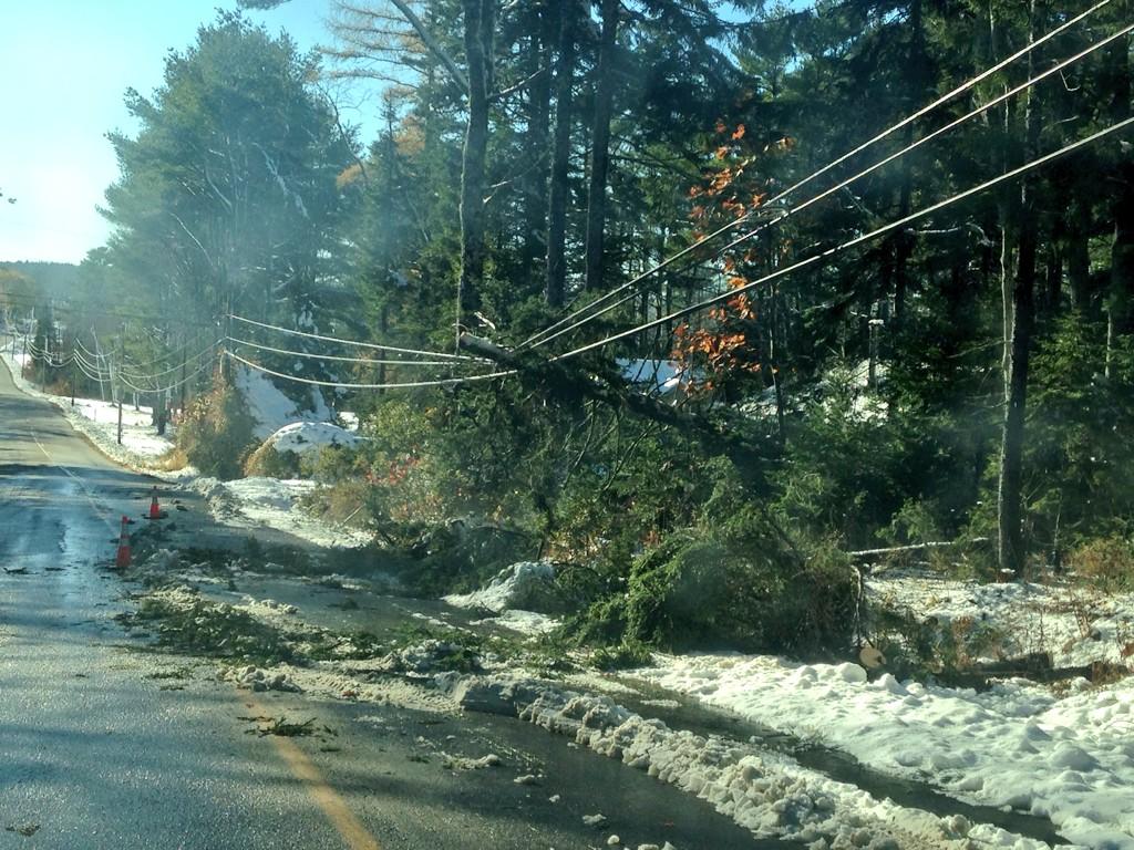
100,000 Still Without Power In Maine

100,000 Still Without Power In Maine


Warmer temperatures helped Mainers dig out of a surprise early snowfall Monday, but more than 100,000 customers remained without power, and it could be several more days before electricity is restored, authorities said.
Power companies called in Canadian crews to help with hundreds of downed trees, power lines and transformers, and Gov. Paul LePage declared a state of emergency as utilities struggled to restore electricity to 106,000 customers a day after Sunday's storm dropped as much as two feet of snow on some parts of the state. Many towns established emergency shelters, and long lines snaked toward the occasional gas station that somehow managed to stay open.
In Ellsworth in Hancock County, Nathan Levandoski was gearing up for a second night of nonstop business at the only open gas station in town after "the craziest night that I have ever lived in my life."

View image on Twitter

Record Early Double-Digit Snow in Maine After Record Early Snow Hits South Carolina


Record Early Double-Digit Snow in Maine After Record Early Snow

New England snowfall totals

A record-early double-digit snowfall blanketed parts of Maine from a storm system that earlier brought an unprecedented early-season snow to parts of South Carolina on the first day of November.

The Aroostook County village of Cary, Maine, near the Canadian border, reported 21 inches of snow just before 7 p.m. EST Sunday. Farther south in the state while Hampden reported 15.5 inches of snow. Including these reports, at least 18 different locations in Maine have recorded 12 or more inches of snow.
Bangor (12 inches) and Caribou (10.1 inches), Maine both set their record earliest double-digit snowfall days, besting records from Nov. 15, 1962 and Nov. 20, 1945, respectively, according to the National Weather Service office in Caribou.
Snow and wind had knocked out power to some 130,000 customers in Maine alone as of Sunday evening as the heavy wet snow and 40-mph gusts brought down tree limbs and power lines. The counties of Penobscot, Hancock, Knox and Lincoln have been hardest hit thus far. The state governor declared a state of emergency and one power utility declared a "system emergency" due to the damage.

Severe Storms Lash Buenos Aires

Violent storms lashed central Argentina producing floods, power cuts and traffic chaos. [EPA]

Torrential rain and violent winds smashed through Buenos Aires and the surrounding region on Wednesday causing widespread disruption. There was some damage to buildings, trees were uprooted and streets flooded in knee-deep water.

Cabinet chief, Jorge Capitanich confirmed that 5,000 policemen were deployed to the 17 damaged areas to deliver provisions and aid those worst affected. In the city of Bragado, 200km from Buenos Aires, tiles were ripped off roofs and power lines were toppled leaving residents without running water and electricity. There was also a report of at least one tornado. Buenos Aires had 139mm of rain on Thursday. The October average is only 86mm so it comes as no great surprise that severe flooding occurred and at one stage the Luján River was rising at around 20cm per hour.

According to the Civil Defense director of Buenos Aires, Daniel Russo, more than 100 trees were brought down across the city. The heaviest rain is now clearing the River Plate, but heavy downpours are still likely to affect Uruguay and southern Brazil this over the next few days.

http://www.aljazeera.com/weather/2014/10/severe-storms-lash-buenos-aires-20141030125342530783.html 

Snowstorm Allows Southeast Ski Resorts to Boast Early Opening Day

"We're making lots of snow, lots of it," Sugar Mountain Ski Resort in North Carolina boasted on Sunday, after a storm delivered 8-10 inches of natural snow to the slopes over the weekend.
The bounty of the early snowstorm, paired with ideal temperatures for snowmaking, afforded the resort a head-start into the 2014-2015 winter season, beating the opening days of many competitors farther north.Sugar Mountain officially opened on Nov. 2, the second earliest opening on record, just behind the Oct. 31 record set two years ago. "It's exciting to get the winter season started early," Owner and President Gunther Jochl said. The storm delivered more than a foot of snow to parts of the southern Appalachians, setting a new date for the earliest snowfall in recorded history for Columbia, South Carolina.
"This was unusual because it occurred right at the start of November," AccuWeather.com Lead Long-Range Forecaster Paul Pastelok said. "To get a storm this early that far south is pretty impressive. It's more typical of late November into early December," he said.Sugar Mountain was one of two resorts in the state to take the risk of opening early, despite temperatures forecast to waffle back and forth through the middle of November. Highs could again rise into the 60s at times.
Farther north, two New England resorts also committed to opening this week after double-digit snow totals broke new early-season records in some areas. Sunday River Resort opened a single expert-level trail on Monday, with plans to then close again through Friday in order to make snow for the weekend.Killington Resort in Vermont also opened to season pass holders Monday, with the general public opening on Tuesday. "This is no surprise and we typically see northern New England skiing any time around Halloween," Andrew Davis, media partnerships director for Snocountry Ski Areas Association said. "There is some friendly competition to open first and begin to offer the most open terrain. But a resort will let the weather dictate if they are going to commit the resources to making snow...," he said.
http://www.accuweather.com/en/weather-news/southeast-early-opening-day-ski/36790016

Wintry Conditions in Chicago: Lake Michigan Overflows onto Lake Shore Drive; Over 300 Cancelations at O'Hare

Wintry Conditions in Chicago: Lake Michigan Overflows onto Lake Shore Drive; Over 300 Cancelations at O'Hare


Not only is Chicago experiencing its first snowfall of the season, gusty winds are also producing troubling conditions for both commuters and travelers.

Wind gusts as high as 53 mph were recorded at the Chicago Midway International Airport. Wind gusts reached 49 mph at the Chicago Executive Airport. Nearby in Gary, Indiana, winds gusted as high as 69 mph at the Gary/Chicago International Airport.
ABC-7 reports that high winds  and led to closures on Lake Shore Drive’s northbound lanes. The windy conditions were created by a rapid change of air pressure.
"When an area of low pressure sets up near an area of high pressure, air flows quickly from high to low in the form of wind. The greater the pressure differences, the faster the wind speeds that can develop,” weather.com meteorologist said.
O’Hare International Airport canceled over 300 flights because of the weather, , NBC Chicago reports.
According to the National Weather Service, at both the Chicago O’Hare Airport and the Rockford Airport. This is the first measurable snowfall recorded in Chicago on Halloween.

http://www.weather.com/news/commuter-conditions/chicago-snow-winds-impacts-20141031