Tuesday, September 3, 2019

Dorian nears U.S. as mega-storms become yearly threat

Hurricane Dorian could be the fifth major storm to threaten the United States in three years, driving home scientists' warnings that climate change is shaping powerful tropical systems.
Dorian is expected to sweep near the Florida coast as a Category 4 or 3 storm later today, but it will be remembered as one of the strongest Atlantic hurricanes in history. The deadly storm bore down on the Bahamas over the weekend with sustained winds of 185 mph.
Yesterday, Dorian stalled out over Grand Bahama, lashing the 50,000-resident island with rain and damaging winds before moderating to a strong Category 4 storm in the afternoon. By 11 p.m. EDT, the National Hurricane Center measured sustained winds of 130 mph. 
Dorian killed at least five people in the Abaco Islands in the northern Bahamas, Bahamian Prime Minister Hubert Minnis announced yesterday afternoon. He said the storm was an unprecedented event in the independent British commonwealth of 400,000 people.
Scientists have warned that hurricane intensity will rise over the next century as ocean waters warm, providing more energy to tropical systems as they move toward land. Research since 2017 has borne out such predictions, with larger, wetter and more destructive hurricanes occurring almost annually.
Hurricane Dorian as seen yesterday from the International Space Station. Photo credit: Christina H. Koch/NASA


Link to article

Daily downpours to raise flood risk in north-central, western India into next week

Locally heavy rainfall will continue to inundate parts of north-central and western India this week as a monsoon low tracks westward across the country. This monsoon low will pack an extra punch, as it absorbed moisture from former Tropical Storm Podul as it spun over the Bay of Bengal last weekend.
By midweek, downpours will stretch from western Odisha and Chhattisgarh into western Madhya Pradesh, eastern Gujarat and southeastern Rajasthan.
Downpours will continue in similar areas into this weekend with a weekly rainfall total of 75-150 mm (3-6 inches) from eastern Gujarat to coastal Odisha. An AccuWeather Local StormMax™ of 300 mm (12 inches) is possible.
These daily downpours will bring the risk of localized flooding and travel disruptions. There will also be a risk of mudslides in areas of rugged terrain. Aside from the risk of flooding, thunderstorms will also produce frequent lightning that will endanger anyone caught outdoors.
Downpours will continue to affect similar locations early next week continuing the risk for flooding and mudslides.

India 9/3

Link to article 

Another Tropical Storm

A second, smaller tropical storm may make landfall in North America this week, following Hurricane Dorian's devastation of the northwest Bahamas.
Tropical Storm Fernand formed in the Gulf of Mexico and has triggered tropical storm warnings across the northeast Mexican coastline, from Barra del Tordo to the mouth of the Rio Grande River at the far-southeastern point of Texas near Brownsville. According to an advisory today (Sept. 3) from the National Hurricane Center (NHC), Fernand should bring tropical storm conditions to the region late Wednesday (Sept. 4) or early Thursday (Sept. 5), with rainfall being the most serious threat. Parts of South Texas can also expect significant rain, the center reported. As of 1 pm EDT, Fernand was packing maximum sustained winds of 40 mph (65 km/h).

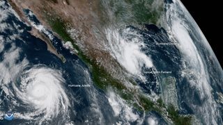
An image from the National Oceanic and Atmospheric Administration (NOAA)'s GOES-West satellite shows three tropical storms near North America at 1:20 pm EST Sept 3, 2019. From left to right: Hurricane Juliette, a Category 3 storm, is not expected to impact land; Tropical Storm Fernand is expected to landfall in Mexico; Hurricane Dorian, now a Category 2 after its devastation of the northwest Bahamas, has grown in area and is making its way toward Florida.

Link to article 

Tropical Storm Fernand

A Tropical Storm Fernand has formed in the Gulf of Mexico. The storm is moving towards the west near 7mph, and is it expected to continue moving. In addition, the government of Mexico issued a tropical storm warning for the Northeast coast of Mexico from La Pesca to Barra del Tordo and from Barra El Mezquital to the Mouth of the Rio Grande River. The news state that as of 2 p.m Fernand was about 160 miles east of La Pesca with a maximum wind of 40mph. Mexico I expected to drop 6 to 12 inches of rain with isolated pockets of 15 inches. It is stated that after the Tropical Storm Fernand, the next storm names would be Tropical Storm Gabrielle. It is shown that the hurricane season typically peaks between mid- August and late October. The storm in Golf of Mexico is not expected to be a  threat to the Louisiana or the northern Gulf coast. The Fernand is forecast to maintain it's tropical storm strength as it  moves slowly west-northwest through the middle of the week. 

Links to the Article's:
1.https://www.orlandosentinel.com/weather/hurricane/os-ne-tropical-storm-fernand-watch-tuesday-20190903-r42uo754dzhenkqmosnsk2p2v4-story.html
2.https://www.nola.com/news/hurricane/article_2a767b20-ce4b-11e9-b9d2-47218a7e3276.html


Siberia just experienced wildfires on a staggering scale. Russia is rethinking how to fight them

Four years ago, Russia instituted a policy of letting remote forest fires burn unless it made sense economically to put them out. Environmentalists warned that the new rules would intensify Siberia’s annual fire season and release more greenhouse gases into the air. The public, for the most part, didn’t pay attention to the regulation change.

That changed this summer when fires swept quickly through thousands of square miles of Siberian forest and strong winds spread smoke and ash across a third of the country. For several days, dark clouds blanketed the cities of Novosibirsk and Krasnoyarsk — each home to more than a million people — hundreds of miles from the fires’ epicenter.

Siberians begged the government to ignore the cost efficiency regulations and extinguish the remote fires. Russian President Vladimir Putin finally sent in military planes and helicopters to douse the flames. Now Prime Minister Dmitry Medvedev has ordered the government to examine the “control zone” burn regulations when parliament meets next month. A change in the policy could have far-reaching benefits in the fight against climate change.

Russia has the largest forested area in the world, covering about 45% of the country. Much of that forest is remote and difficult to reach, which creates unique challenges when battling fires, whether they are in the taiga forests of the Krasnoyarsk region or the Arctic tundra in the republic of Sakha.
Rains and cooling temperatures in Siberia this month have helped keep the fires in check for the moment, but Greenpeace estimated in mid-August that only 9% had been extinguished and that by the end of the season the burn area could break the 2012 record of nearly 70,000 square miles. It estimated that the fires had already released 138 megatons of carbon dioxide, more than the annual emissions of many countries.

https://www.latimes.com/world-nation/story/2019-08-21/russia-siberia-forest-fires-policy-change


Sunday, September 1, 2019

Hurricane Dorian

A category 5 Hurricane Dorian has strikes the Bahamas with 185 mph winds and gusts over 220 mph as the storm inched toward Florida's coast. Central Florida might be another destination where the Hurricane Dorian might strike. A hurricane watch was added for roughly 175-mile stretch of Florida's east coast. The NHC stated that. "This is tied for the strongest Atlantic hurricane landfall on record with the 1935 Labor Day". The storm in Bahamas ripped off roofs and also tore down  power lines in addition  other damage was caused by the hurricane. On the other hand, Central Florida is not projected to take a direct hit although, it could begin to see residual impact from the catastrophic storm. South Florida will experience showers and gusty winds. Schools begin to close as the Hurricane Dorian approaches. Residents of Florida must evacuate St. Johns County. There are roughly 148,500 residents in the St. Johns County under mandatory evacuation. "St. Johns County has issued mandatory evacuation orders for people in Zones A and B. These zones include the entire City of St. Augustine Beach and those living on waterfront properties or floor-prone areas. A mandatory  evacuation order has also been issued for people in Hastings and Flagler Estates".

Link to article's:
1. https://www.orlandosentinel.com/weather/hurricane/os-ne-hurricane-dorian-central-florida-weather-update-20190901-ve6t4h7pgrcgtbz66ghgbz7qfm-story.html 
2. https://www.cnn.com/us/live-news/hurricane-dorian-september-2019/index.html

Tuesday, August 27, 2019

Lightning Strikes in The Tatra Mountain

On August 22, 2019 a lightning struck in the Southern Poland in the Tatra Mountain. The lighting killed five people in addition is has injured over hundred's of others. Individuals state that the thunderstorm came fast and suddenly. The weather during the day was sunny although the weather channel predicted the possible thunderstorm in the Tatra Mountain. The lightning strikes the Giewont peak that is 6,214 feet high as well as other locations across the Tatras. Tourists who were on the peak of the Giewont Mountain were exposed to series of lightning strikes. This accident  is one of  the  most tragic accident caused by lightning  strikes in years. The last such an event that has occurred on the Giewont Mountain in Poland has been in 1937 where four  people were pronounced dead and thirteen individuals were injured by the lighting.

Image of the lightning on August 22, 2019


https://www.nytimes.com/aponline/2019/08/22/world/europe/ap-eu-poland-storm-deaths.html