Sunday, September 28, 2014

Hurricane Rachel Swirling in the Eastern Pacific


Hurricane Rachel is swirling about 450 miles west-southwest of the southern tip of Baja California. It is moving towards the north-northwest at about 10 mph.
Wind shear, or changing wind direction and/or speed with height, diminished slightly, allowing Rachel to strengthen to hurricane status.
Over the next couple of days, however, the system will track over cooler waters as well as move into a region of more stable air and stronger wind shear; this will induce a weakening trend.
Rachel is now drifting toward the north to northwest. Over the next few days Rachel's movement will remain slow and should eventually turn back toward the southwest. At times Rachel may meander erratically.
In any case, Rachel will stay well to the west of the Baja California peninsula, and therefore poses no threat to land.
This is now the third busiest eastern Pacific hurricane season on record, as measured by the number of season-to-date named storms, according to The Weather Channel hurricane specialist Michael Lowry. Only 1992 (19 storms) and 1985 (20 storms) were busier, says Lowry.

206 Million Pounds of Toxic Chemicals Dumped Into U.S. Waterways in One Year, Study Finds

In just one year, American waterways were filled with 206 million pounds of toxic chemicals, according to a report conducted by the Environment America Research and Policy Center. The report, Wasting Our Waterways, cites the mid-Atlantic, Ohio River and South Atlantic-Gulf Coast watershed regions as the most polluted, with more than 20 million pounds of toxicity released into each of those waterways.

It's important to note that these toxic dumps are done legally and are monitored by the U.S. Environmental Protection Agency. Each company is required to declare how much toxic material will be dumped, and the EPA will monitor each corporation to ensure they're not exceeding their limit.

The report was released as the EPA was set to enact new laws to protect another two million miles of waterways with Clean Water Act requirements, Nature World News reports. Oct. 18 will mark the 42nd anniversary of the Clean Water Act becoming law.

(there was no photo for this article) 

http://www.wunderground.com/news/206-million-pounds-chemicals-water-study-20140923

Phoenix Pounded By Intense Storms

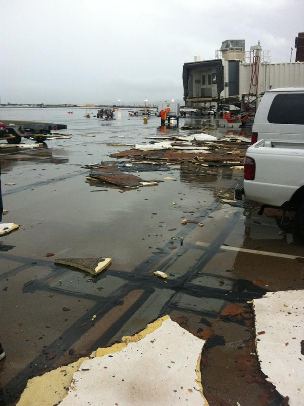
Sunday morning, Phoenix area residents woke up to debris scattered on roadways and toppled trees after the area experienced a powerful storm Saturday afternoon. Roads were flooded and flights were delayed after the area was hammered with heavy rains and strong winds.  51,000 residents were left without power, but the Salt River Project utility said that this number has been lowered to 800. Strong winds, thunder and a cascade of rain pounded the city, littering streets with downed trees and causing damage at the Phoenix airport.
Enough rain fell to create flash flood conditions on I-17 at Durango Curve, forcing authorities to close a section of the interstate. As much as 1.59 inches of rain fell at the Phoenix Sky Harbor International Airport, which broke the old daily rainfall record that was set in 1903. Throughout Phoenix, wind gusts exceeded severe limits, including the 67 mph wind gust recorded near Luke Air Force Base as well as the 71 mph wind gust recorded east of Peoria in Maricopa County.
Flight departures and landings were halted at Phoenix Sky Harbor International Airport for about an hour as 67 mph wind gusts produced roof and window damage at one of the airport's terminals. Airport spokeswoman Julie Rodriguez said the wind caused some damage to the roof of Terminal 2 in the baggage claim area and in some of the gate areas. However, all three terminals at Sky Harbor were operational. More than 30 flights scheduled to land in Phoenix were diverted to other airports. Rodriguez also stated that takeoffs and landings were halted between 2:30 and 3:30 p.m. due to the winds and heavy rain. 
View image on Twitter
http://www.weather.com/safety/floods/intense-phoenix-storms-20140927

Atlantic warming turbocharges Pacific trade winds


New research has found rapid warming of the Atlantic Ocean, likely caused by global warming, has turbocharged Pacific Equatorial trade winds. Currently the winds are at a level never before seen on observed records, which extend back to the 1860s.
The increase in these winds has caused eastern tropical Pacific cooling, amplified the Californian drought, accelerated sea level rise three times faster than the global average in the Western Pacific and has slowed the rise of global average surface temperatures since 2001. It may even be responsible for making El Nino events less common over the past decade due to its cooling impact on ocean surface temperatures in the eastern Pacific.
"We were surprised to find the main cause of the Pacific climate trends of the past 20 years had its origin in the Atlantic Ocean," said co-lead author Dr Shayne McGregor from the ARC Centre of Excellence for Climate System Science (ARCCSS) at the University of New South Wales. "It highlights how changes in the climate in one part of the world can have extensive impacts around the globe."
The record-breaking increase in Pacific Equatorial trade winds over the past 20 years had, until now, baffled researchers. Originally, this trade wind intensification was considered to be a response to Pacific decadal variability. However, the strength of the winds was much more powerful than expected due to the changes in Pacific sea surface temperature. Another riddle was that previous research indicated that under global warming scenarios Pacific Equatorial Trade winds would slow down over the coming century.
The solution was found in the rapid warming of the Atlantic Ocean basin, which has created unexpected pressure differences between the Atlantic and Pacific. This has produced wind anomalies that have given Pacific Equatorial trade winds an additional big push.
"The rapid warming of the Atlantic Ocean created high pressure zones in the upper atmosphere over that basin and low pressure zones close to the surface of the ocean," said Prof Axel Timmermann co-lead and corresponding author from the University of Hawaii.
"The rising air parcels, over the Atlantic eventually sink over the eastern tropical Pacific, thus creating higher surface pressure there. The enormous pressure see-saw with high pressure in the Pacific and low pressure in the Atlantic gave the Pacific trade winds an extra kick, amplifying their strength. It's like giving a playground roundabout an extra push as it spins past."
Many climate models appear to have underestimated the magnitude of the coupling between the two ocean basins, which may explain why they struggled to produce the recent increase in Pacific Equatorial trade wind trends. While active, the stronger Equatorial trade winds have caused far greater overturning of ocean water in the West Pacific, pushing more atmospheric heat into the ocean, as shown by co-author and ARCCSS Chief Investigator Prof Matthew England earlier this year. This increased overturning appears to explain much of the recent slowdown in the rise of global average surface temperatures.
Importantly, the researchers don't expect the current pressure difference between the two ocean basins to last. When it does end, they expect to see some rapid changes, including a sudden acceleration of global average surface temperatures. "It will be difficult to predict when the Pacific cooling trend and its contribution to the global hiatus in surface temperatures will come to an end," Prof England said.

Climate change report identifies 'the most vulnerable' sections of the population

A report has looked at which sections of the population are left most exposed to food shortages after extreme weather events. Extreme weather events leave populations with not enough food both in the short- and the long-term. A new report by the Environmental Change Institute (ECI) at the School of Geography and the Environment at the University of Oxford concludes that better governance could have lessened the impact on the poorest and most vulnerable, and affected populations have been let down by the authorities in the past.
The report, commissioned by the charity Oxfam, tracks the effects on four countries: Russia which experienced a heatwave in 2010; flood-hit Pakistan the same year; East Africa during the drought of 2010-2011; and the Philippines after Typhoon Haiyan in 2013. The researchers conclude that the authorities in each of the countries studied were unprepared for extreme weather events, and citizens suffered even more than they needed to.
The report, 'A Sign of Things to Come?', says that the Russian heatwave led to a hoarding of food supplies and price-fixing by speculators, which compounded food shortages and led to global wheat prices rising dramatically. It also suggests this could possibly be linked with the political upheaval in the Middle East, with Egypt's hungry protestors suffering the most. In Pakistan, 'coercive landlords' took advantage of smallholders and others affected by the floods, says the report. Overall, the flooding is estimated to have led to an 80% rise in wheat and rice prices in 2010.
The drought-affected people of East Africa did not receive international or domestic aid for six months, partly due to the risks posed by armed groups. Food prices reached record levels in several markets including wheat in Ethiopia, maize in Kenya and red sorghum grain in Somalia, says the report. It notes that children under five accounted for over half of all deaths in Somalia.
Meanwhile in the Philippines, although storm surges were not a new problem, they were not properly understood by central and local governments, says the report. The exceptional storm surge associated with Typhoon Haiyan hit farmers and fishing communities particularly hard, with women, children and some ethnic minorities facing discrimination with aid distribution.
On a global level, the report warns that climate change is expected to increase the intensity and frequency of heatwaves and floods. It says although there is no scientific evidence to show a specific weather event would not have happened without climate change, scientists can estimate whether it increases the risk of an event. It finds that the Russian heat wave and the East African drought were more likely because of climate change, but there is not yet the evidence to say that climate change played a part in the floods in Pakistan or Typhoon Haiyan.

The Fickle El Niño of 2014

The image shows Kelvin waves of high sea level (red/yellow) crossing the Pacific Ocean at the equator. The waves can be related to El Niño events. Green indicates normal sea level, and blue/purple areas are lower than normal. Data are from the NASA/European Jason-2 satellite, collected Sept. 13-22, 2014.

The latest sea-level-height data from the NASA/European Ocean Surface Topography Mission (OSTM)/Jason-2 satellite mission show a pair of eastward-moving waves of higher sea level, known as Kelvin waves, in the Pacific Ocean -- the third such pair of waves this year. Now crossing the central and eastern equatorial Pacific, these warm waves appear as the large area of higher-than-normal sea surface heights (warmer-than-normal ocean temperatures) hugging the equator between 120 degrees west and the International Dateline. The Kelvin waves are traveling eastward and should arrive off Ecuador in late September and early October.
A series of larger atmospheric "west wind bursts" from February through May 2014 triggered an earlier series of Kelvin waves that raised hopes of a significant El Niño event. Just as the warming of the eastern equatorial Pacific by these waves dissipated, damping expectations for an El Niño this year, these latest Kelvin waves have appeared, resuscitating hopes for a late arrival of the event.
Climatologist Bill Patzert of NASA's Jet Propulsion Laboratory, Pasadena, California, says it's too early to know for sure, but he would not be surprised if the latest Kelvin waves are the "last hurrah" for this much-hoped-for El Niño. "Since February 2014, the prospect of an El Niño has waxed and waned. This late in the season, the best we can expect is a weak to moderate event. What comes next is not yet clear. But for the drought-plagued American West, the possibility of a badly needed drenching is fading," said Patzert. NASA scientists will continue to monitor the Pacific to see what is in store next for the world's climate.

http://www.sciencedaily.com/releases/2014/09/140923153617.htm

Saturday, September 27, 2014

‘Dangerous Storm’ Brings Rain, Lightning and Flooding to Parts of SoCal; Possible Funnel Cloud Spotted

Lightning strikes in the Temescal Valley area, southeast of Corona, on Sept. 16, 2014. (Credit: Will Wilkens)

As the region suffered through a fourth day of triple-digit temperatures, wild weather swept through parts of Southern California late Tuesday afternoon, causing flooding and damage in areas of the Inland Empire.

Southwestern Riverside County and eastern Orange County — including Riverside, Temecula, Corona, Hemet and Mission Viejo — were among the areas affected by the sudden summer storm, which included heavy rain, lightning and hail in the afternoon hours.
 
One of the areas hardest hit by the severe weather was Wildomar, which is located in Riverside County not far from Lake Elsinore.
 
The thunderstorm caused serious damage at Elsinore High School, tearing up the track, pummeling the school’s baseball dugout and metal batting cages and filling some buildings and classrooms with water that was knee-deep.

A staff member described the frightening moments of being caught up in the storm, likening it to a movie.

“It was insane. It was like that scene in ‘Twister’ where everything is flying around. I was waiting to see the cow to go by,” said Shannon Atkins, a staff member at the school. “We couldn’t get to safety, we were just right there holed up and there was nothing we could do.

http://ktla.com/2014/09/16/severe-thunderstorm-warning-issued-for-parts-of-orange-county-inland-empire/