Wednesday, September 18, 2019

Flash Flood Threat for Parts of Texas Including Louisiana from Imelda

Parts of the Texas Gulf Coast are experiencing their heaviest rainfall event since Hurricane Harvey. A dangerous deluge dumping rainfall at rates approaching 4 to 6 inches per hour in spots. The rains are from slow-moving thunderstorms associated with tropical depression Imelda, which made landfall Tuesday as a weak tropical storm.Wednesday marks day two of a three-day drenching that has the Houston and Galveston metro areas squarely in its sights, the latest in several seemingly routine hundred-year rain events to plague the region in recent years. Flash-flood watches blanket the map, and the Weather Prediction Center in Maryland has declared the region to be at “high risk” for excessive rainfall. Through daybreak Wednesday, Houston had dodged most of the heaviest rain bands, while Galveston — the coastal city 45 miles to the southeast — has been clobbered by repetitive rounds of squalls all morning - with rainfall totals topping 8 inches. Radar-estimated rain totals of 13 to 15 inches had been observed along the Matagorda coast near Freeport, where Imelda — the super-soaked depression spurring the inundations — made landfall Tuesday afternoon.
Link to article:
https://www.washingtonpost.com/weather/2019/09/18/texas-gulf-coast-experiencing-life-threatening-flash-flooding-tropical-depression-imelda/

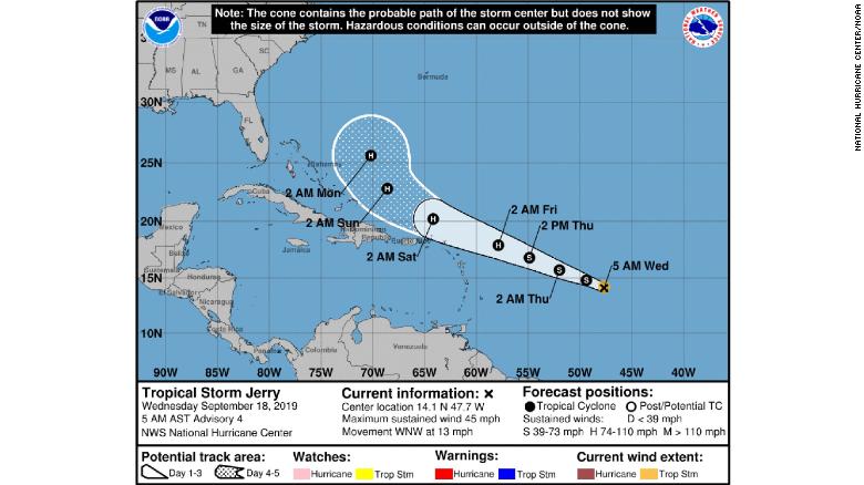
Hurricane Jerry in Atlantic- Possible Hurricane Later This Week

Jerry, the 10th named storm of this year's Atlantic hurricane season, was 855 miles east of the Leeward Islands late Wednesday morning. It had maximum sustained winds of 50 mph, the National Hurricane Center said.

From NHC: The cone contains the probably path of the storm center but does not show the size of the storm. Hazardous conditions can occur outside of the cone. The storm is expected to become a hurricane by Thursday night, It's too soon to tell if the islands will be affected, forecasters said.

https://www.cnn.com/2019/09/18/us/tropical-storm-jerry-wednesday-wxc/index.html

Tuesday, September 17, 2019

Imelda makes landfall in Texas, Houston prepares for flooding

While Imelda has lost wind intensity as it continues to move inland, dangers are just beginning for the Houston area and other places in eastern Texas that can receive up to 18 inches of rain.
The rapidly developing system strengthened into Tropical Depression Eleven on Tuesday at Noon CDT and one hour later was dubbed Tropical Storm Imelda. However the storm ]downgraded to a tropical depression on Tuesday night.
The development of Imelda occurred just a few hours after Tropical Depression Ten formed over the central Atlantic.
Torrential rainfall will be unleashed as Imelda continues to move inland. Isolated tornadoes and waterspouts may be spawned.
Enough rain is forecast to fall to cause significant street, highway and low-lying area flooding from southern Louisiana to the middle of the Texas coast. This includes the cities of Lake Charles, Louisiana, to Beaumont, Houston, Galveston, Matagorda, Victoria and Corpus Christi, Texas, this week.
A general 6-12 inches of rain is likely to fall in this swath with an AccuWeather Local StormMax™ of 18 inches into Friday.
Turkey Creek in Humble Camp, Texas received more than 6 inches of rain on Tuesday within the span of 24 hours due to Imelda.
On Tuesday night, gauges on Chigger Creek at Windsong and Cowart's Creek at Cloverfield near Friendswood were nearing their banks and flooding was expected to begin shortly, according to the National Weather Service in Houston.


Hurricane Humberto to Pass Near Bermuda

Hurricane Humberto is to pass near Bermuda during the midweek. Hurricane Humberto is likely to track near Bermuda by later Wednesday, potentially bringing strong winds, battering surf and heavy rain to the archipelago. Humberto will also continue to generate high surf and dangerous rip currents along the Southeast U.S. coast. A tropical storm warning is in effect for Bermuda. This means tropical-storm-force winds (39-plus mph) are expected, generally within 36 hours. Humberto could become a Category 3 hurricane by Wednesday. Humberto's wind field size has grown in size, increasing the chance of at least tropical-storm-force winds arriving as soon as late Wednesday. Humberto may bring periods of heavy rain to Bermuda beginning later Tuesday, and large swells generated by the hurricane will increase along the coast of Bermuda by Wednesday. Residents and visitors in Bermuda should be preparing for these Humberto will continue to bring high surf and dangerous rip currents to the southeastern U.S. coast the next couple of days as well. Beachgoers from the east coast of Florida to North Carolina should stay out of the water.For now, Humberto's center should remain well off the rest of the Eastern Seaboard late this week. However, high surf and rip currents appear likely to spread up the East Coast later this week and may linger into the weekend. 


Link to article:
https://weather.com/storms/hurricane/news/2019-09-15-hurricane-humberto-forecast-bermuda-southeast-coast-rip-currents


Lightning 'superbolts' form over oceans from November to February

Lightning superbolts -- which unleash a thousand times more low-frequency energy than regular lightning bolts -- occur in dramatically different patterns than regular lightning, according to a new, nine-year survey of these rare events.

https://www.sciencedaily.com/releases/2019/09/190909113041.htm

Monday, September 16, 2019

Marginal risk of severe thunderstorms across the Chicago area

  Elevated thunderstorms are ongoing in western IA on the leading edge
   of a low-level warm theta-e advection plume. This plume and
   attendant zone of ascent will spread east-northeast across the Upper
   MS Valley into tonight in advance of a low-amplitude shortwave
   trough near the ND/MB border that will move east-southeast into Lake
   Superior. This elevated convection will pose a threat for isolated
   large hail, mainly this evening into tonight with a probable decay
   cycle this afternoon. A risk for locally damaging winds may also
   develop tonight towards the IA/IL/WI border region if a cluster can
   become semi-organized. 

  
 In the wake of the warm advection regime, storm initiation will
   depend on weak low-level ascent along a surface trough that extends
   southwestward across NE/KS. Stronger surface heating and deeper
   mixing is expected along the trough in KS, with lesser mixing depths
   and a greater probability of maintaining MLCIN through the afternoon
   in the warm sector farther northeast. Thus, surface-based
thunderstorm development should be sparse and may struggle to be sustained during the late afternoon/early evening. If surface-based storms can form as far northeast as southern MN this afternoon, vertical shear profiles will be sufficient for supercells. Weaker vertical shear is expected with southwestward extent into southwest KS, where high-based storms would pose a threat for isolated severe wind and hail.

Extreme weather events (and the costs) are piling up

By Dante Chinni WASHINGTON 

There were 93 named storms in the Atlantic in the 1980s. There were 110 named storms in the Atlantic in the 1990s and a whopping 151 in the first decade of this century. The tally sits at 150 for the current decade and we are still at the peak of the 2019 season. The number of major hurricanes, above category 3, is also up since 1980, though down a bit from the last decade (so far).
But the growth of extreme weather extends beyond hurricanes. An analysis of weather disasters that did more than $1 billion in damage from the National Centers for Environmental Information finds that such high-cost events are up markedly since the 1980s. (The dollar figures for the events were adjusted for inflation.)

https://www.nbcnews.com/politics/meet-the-press/extreme-weather-events-costs-are-piling-n1054576