Tuesday, March 5, 2013
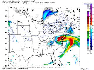
High-Impact Snow Storm Headed for Mid-Atlantic
The Mid-Atlantic states are bracing for a high-impact, heavy snowstorm starting late Tuesday and lasting through Wednesday. The storm has the potential to paste parts of Virginia and Maryland with more than a foot of snow, while ending Washington, D.C.’s longest snow drought on record. The nation’s capital hasn’t received two inches or more of snow in a single event since Jan. 26, 2011, the longest such stretch since weather records began there in the late 1800s.
The prospect of heavy, wet snow along with high winds means that this storm poses a significant risk of power outages in a region that experienced lengthy power disruptions following severe thunderstorms last summer and Hurricane Sandy last fall.
The storm also threatens to cause coastal flooding from Virginia northward, possibly all the way to Massachusetts. The National Weather Service office in Philadelphia warned of the potential for “major coastal flooding” to take place along the vulnerable New Jersey shoreline, which was severely damaged during Sandy in October 2012. Fortunately, astronomical tides are not running particularly high, which should limit the flooding potential.
http://www.climatecentral.org/news/high-impact-snowstorm-headed-for-mid-atlantic-15687
Labels:
Katie Sinner
Subscribe to:
Post Comments (Atom)

No comments:
Post a Comment