Showing posts with label Amanda Hill. Show all posts

Thursday, December 6, 2012

Bad news for movie fans, U.S. drought hits popcorn crop

http://www.reuters.com/article/2012/09/02/us-usa-drought-popcorn-idUSBRE88101W20120902

A young baseball fan makes sure there's not a kernel of popcorn left as she watches the Chicago Cubs play the Arizona Diamondbacks during their MLB National League baseball game in Phoenix, Arizona, June 24, 2012. REUTERS/Darryl Webb


Reuters) - For more than half a century, the Shew family has harvested mountains of popcorn kernels to be buttered, salted and munched by movie fans.
But as a crippling Midwestern drought sends commodity soybean and grain prices soaring, the family's farmland in west-central Indiana is suffering. Plants are listing, stalks are spindly and corn ears small.
It's an ill portent for the snack food world. All across the Midwest, where rows of popcorn normally thrive alongside fields of soybeans, U.S. popcorn farmers have watched in horror as stifling, triple-digit temperatures and weeks without rain withered crops.
"This is the worst season we've ever had," said third-generation popcorn purveyor Mark Shew, who runs the family's farm in Vigo County. "In some places, they're going to be down to counting kernels at the bottom of the storage bins."

What The Drought Of 2012 Tells Us About Industrial Agricultur

What The Drought Of 2012 Tells Us About Industrial Agriculture


http://www.fastcoexist.com/1680430/what-the-drought-of-2012-tells-us-about-industrial-agriculture


The summer’s extreme weather is starting to expose cracks in the system.
I grew up on farms in Iowa and Wisconsin, surrounded by a family of farmers and agricultural workers, all of whom grew corn. I have never heard any farmer say, “Wow, we got the perfect amount of rain this year.” It’s never perfect, and farming is a tough business. There have been droughts before, and it looks like there will certainly be more droughts in the future. However, the summer of 2012 has been historic in several ways:

● July was the all-time warmest month on record in the United States.
● Corn yields are predicted to be the lowest in 17 years.
● Corn futures touched a record high of $8.49 a bushel on August 10.
● July saw a 17-cent jump in the national average gasoline price--the biggest increase for that month on record.
● The United Nations Food and Agriculture Organization reported the largest monthly jump in its cereal price index, up 38 points (17%) from June and only 14 points below its all-time high registered in April 2008.

What Happens in the Arctic Doesn't Stay in the Arctic

http://switchboard.nrdc.org/blogs/dlashof/what_happens_in_the_arctic_doe_1.html


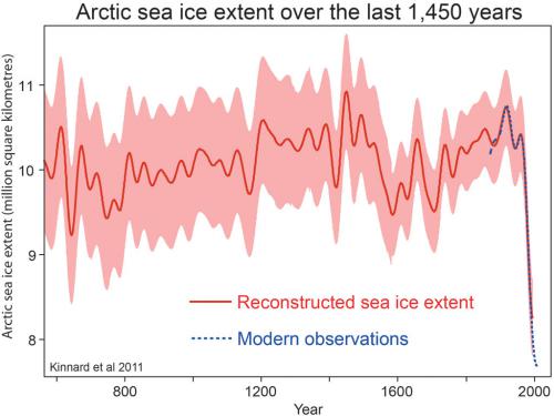
Arctic sea ice extent dropped to the lowest level ever recorded, bottoming out at 3.41 million square kilometers on September 16, according to the National Snow and Ice Data Center (NSIDC). That’s 49 percent below the average minimum recorded during the 1980s and 1990s.
Arctic Sea Ice 9-13-2012
Scientists are confident that this trend is due to pollution. While there are year-to-year fluctuations in the location and extent of arctic sea ice, driven primarily by wind patterns, the best estimates are that the minimum extent never dropped below 9.8 million square kilometers in the first half of the 20th Century and probably not below 9 million in the last 1000 years.  Since around 1950 there has been a clear trend toward less ice, with the minimum extent dropping below 4 million square kilometers for the first time this year.
Wind-driven reorganization of the sea ice also can’t explain the progressive reduction of ice thickness and the declining fraction of ice that has persisted for more than one year. These trends not only bear the fingerprint of human-caused climate change, they mean that the arctic ice is ever more vulnerable to collapse. In fact, arctic sea ice is meltingmuch faster than climate models had predicted.
Unfortunately, what happens in the arctic doesn’t stay in the arctic. The dramatic loss of arctic ice contributes to more extreme weather in the United States in at least three ways.
First, the dramatic reduction in reflective ice in the Arctic Ocean changes the flow of energy in the climate system throughout the northern hemisphere. In particular, it alters the position and shape of the jet stream, favoring a pattern with more pronounced waves. That means that tropical air can penetrate further north and that arctic air can penetrate further south. It also means that weather systems tend to move more slowly from west to east. This is a formula for increasing extreme weather—both persistent excessive heat and severe snow storms.

Thanksgiving turkey to be among first to show drought price hike

http://www.suntimes.com/business/15636481-420/thanksgiving-turkey-to-be-among-first-to-show-drought-price-hike.html

Story Image


The summer’s drought will push food prices higher just in time for Thanksgiving dinner.
Grocery shoppers can expect to see drought-related price increases in the coming weeks on turkey, eggs, vegetable oils and dairy products.

Drought Cuts U.S. Crops Below Demand First Time in 38 Years

Drought Cuts U.S. Crops Below Demand First Time in 38 Years

http://www.suntimes.com/news/nation/16560783-418/drought-worsens-for-more-than-half-of-us-despite-recent-rain.html

Drought damage to corn and soybean fields in the U.S., the world’s top grower and exporter, is eroding supplies of the nation’s two largest crops to below year-earlier consumption levels for the first time since 1974.
The government probably will say tomorrow that the U.S. corn harvest and inventories on Sept. 1 will be a combined 11.604 billion bushels, less than the 12.33 billion consumed and exported last year, according to a Bloomberg survey of 31 analysts. Soybean supplies will be 2.932 billion bushels, below the 3.157 billion used in 2011. Supplies failed to top usage from the previous year only twice since 1960 for corn and five times for soybeans, U.S. Department of Agriculture data show.
Record heat in June and July sparked the worst drought since 1956, sending corn and soybeans prices to record highs. Morgan Stanley predicted corn may rally 35 percent in a year, while Barclays Plc sees soybeans gaining 16 percent. Higher costs for dairies, grain processors and livestock producers helped send global food prices in September to the highest since March, United Nations data show.
“Supplies of both corn and soybeans will be tight, and we expect prices to rebound after the report,” said Bill Tierney, the chief economist for Chicago-based AgResource Co. and a former USDA grain analyst. “There is no evidence that current prices are rationing soybean supplies, and there will be less supply relief for corn” from South American harvests that start in February, he said.


Drought worsens for more than half of U.S. despite recent rain

http://www.suntimes.com/news/nation/16560783-418/drought-worsens-for-more-than-half-of-us-despite-recent-rain.html

The sun rises Sunday July 15 2012 Pleasant Plains Ill. Corn struggled summer hebut there's been little relief as months


ST. LOUIS — The worst U.S. drought in decades has deepened again after more than a month of encouraging reports of slowly improving conditions, a drought-tracking consortium said Wednesday, as scientists struggled for an explanation other than a simple lack of rain.
While more than half of the continental U.S. has been in a drought since summer, rain storms had appeared to be easing the situation week by week since late September. But that promising run ended with Wednesday’s weekly U.S. Drought Monitor report, which showed increases in the portion of the country in drought and the severity of it.

How To Measure Hail

http://www.almanac.com/content/how-measure-hail


Hail falls mainly in the summer. It forms in thunderstorm clouds, which can extend high into the atmosphere where extremely cold temperatures prevail.
When a cloud releases rain, the rain can be forced upward, where it freezes into tiny ice pellets.
If updrafts keep buffeting the pellets, layer upon layer of frozen water will be added to the pellets until, finally, hailstones are released.
Did you know? The largest hailstone ever recorded, as of 2010, fell in Coffeyville, Kansas, on September 3, 1970. It was about 17.5 inches in circumference and weighed more than 26 ounces. During that particular hailstorm, citizens reportedly went out to gather the hailstones wearing football helmets for protection!

Flood warning: will it force UK government to act on climate change?

http://www.guardian.co.uk/environment/2012/nov/27/flood-warning-government-climate-change


With nations meeting in Doha to discuss a global plan to tackle climate change, the terrible floods hitting the UK are a stark warning about the need for urgent action to cut emissions (Labour accuses ministers of flood defence cuts, 27 November). Scientists predict the UK will experience severe flooding more frequently as climate change takes hold. The floods have severely disrupted people's lives and will cost the economy millions of pounds – highlighting the foolishness of the chancellor's insistence in only talking about the costs of tackling climate change. The UK government must stop dragging its feet on decarbonising our economy and show global leadership.
Craig Bennett
Campaigns director, Friends of the Earth
• Would all potential flood victims and actual victims (800 homes hit as rain and high winds cause havoc across the west and north, 26 November) feel more secure if some of the £100bn to be spent on upgrading Trident was instead used to massively upgrade flood defences? Sometimes simple solutions seem so obvious.
Graham Marsden
Bolton

Was it hurricane Sandy that won it for President Obama?

http://www.guardian.co.uk/commentisfree/2012/dec/04/hurricane-sandy-won-president-obama


obama christie sandy


Many forecasted that Mitt Romney would defeat President Obama in the 2012 presidential election. They were wrong. Some of those who were incorrect took it in stride and admitted as much. Others, such as Twitter sensation and National Review blogger Josh Jordan (akaNumbersMuncher), decided that their logic was sound, and it was only because of Superstorm Sandy that Obama won.
At first glance, their logic seems to makes some sense. Obama got good Sandy press, highlighted by nice photos with and words from New Jersey Governor Chris Christie. Polls indicated that Americans approved of Obama's Sandy response. The national polls were biased against Obama, and even some of the state polls were too pro-Obama compared to the final results.
The question is whether the polls indicate that Obama gained in the final days. We can figure this out by comparing pre- and post-Sandy pre-election surveys.
Examining the data in that manner finds that the Sandy theory for Obama's rise is fatally flawed. The majority of polls did not show great movement to the president after Sandy.
The two most accurate national polls were consistent in pegging Obama at a mid single-digit victory. Ten days before Sandy, Democracy Corps had Obama leading by 3 points. In the days after Sandy, Obama gained a statistically insignificant 1pt after Sandy, to be up by 4pt. Rand actually had Obama's lead falling from 5.1pt just prior to Sandy, to 3.3pt in their final tracking poll.

Philippines typhoon death toll worsens


http://www.guardian.co.uk/world/2012/dec/04/philippine-typhoon-bopha-kills-fiveA powerful typhoon made landfall in the south of the Philippines on Tuesday with heavy rain and gusts of up to 120mph Link to this vide
o
The toll of dead and missing from typhoon Bhopa in the Philippines has continued to climb in the worst-hit areas of the coutry's south.
At least 43 people died when torrents of water came down a mountain in New Bataan town in Compostela Valley province, on the island of Mindanao, and engulfed a school and village hall where people were taking shelter from the storm. Nine soldiers and an unspecified number of villages were missing, said army Major General Ariel Bernardo.
Six villagers drowned in floods in Montevista town, Compostela Valley, said a provincial spokeswoman. In nearby Davao Oriental province 51 people died, mostly in floods, while two men perished when fierce wind ripped their boat from its mooring and it sank on central Siquijor island, according to disaster response officials.
Bhopa, one of the strongest typhoons to hit the country this year, struck Davao Oriental at dawn on Tuesday then barrelled across southern and central provinces, triggering landslides, flooding and cutting off power in two entire provinces. It headed towards western Palawan province on Wednesday and was expected to blow out toward the South China Sea on Thursday.
Typhoon Bopha first hit the Davao region at dawn on Tuesday. Gusts of wind of up to 120 miles an hour ripped roofs from homes and a 300-mile wide band of rain flooded low-lying farmland. The storm toppled trees, triggered landslides and sent flash floods surging across the region's mountains and valleys.
Some 20 typhoons and storms normally lash the archipelago nation each year but the southern provinces are unaccustomed to such fierce weather. A rare storm that took the area by surprise last December killed more than 1,200 people and left many more homeless.
Officials were taking no chances this year, and on Monday the president, Benigno Aquino III, appealed for people in Bopha's path to move to safety and take storm warnings seriously.
"This typhoon is not a joke," Aquino said after meeting disaster-response officials. "But we can minimise the damage and loss of lives if we help each other."
Aquino outlined preparations, including evacuations and the deployment of army search and rescue boats in advance. Authorities also ordered small boats and ferries not to venture out along the country's eastern seaboard, warning of rough seas with waves of up to four metres high.
In Compostela Valley authorities halted mining operations and ordered evacuations to prevent a repeat of deadly losses from landslides and the collapse of mine tunnels seen in previous storms.
Bopha, a Cambodian word for flower or a girl, is the 16th destructive storm to hit the Philippines this year. Forecasters say at least one more storm may hit before Christmas.

Sunday, October 14, 2012

Tropics Watch: Tracking Rafael and Paul


We are currently tracking Tropical Storm Rafael in the Atlantic Basin and Tropical Storm Paul in the eastern Pacific. 
The above image is an overview of the Atlantic and eastern Pacific Ocean basins, based on analysis provided by Senior Meteorologist Stu Ostro and Hurricane Specialist Bryan Norcross.  Named storms, hurricanes, or depressions in either basin will be labeled on the graphic.  Any other features of interest we're keeping an eye on for possible development will be circled.

Worst Western U.S. Disasters

http://www.weather.com/news/worst-western-usa-disasters-20121011


This Friday marks the 50th anniversary of one of the most powerful storm systems ever to strike the United States - a storm that produced wind gusts over 170 miles per hour, damaged thousands of homes, and killed dozens of people. But it wasn't a hurricane; it wasn't a Nor'easter; it wasn't a tornado in the Plains. The Columbus Day windstorm that struck the Pacific Northwest on Oct. 12, 1962, was just one example of the fury Mother Nature has unleashed on the West over the course of American history....
...The deadliest flash flood in the history of the Western U.S. occurred in the north-central Oregon town of Heppner on June 14, 1903.
A small but intense thunderstorm parked south of Heppner over the watersheds of Willow Creek, sending water rushing downstream.


Fewer Tornadoes During Drought Year


With all the worry this summer about the hot, dry weather, hardly a word was said about those usual staples in Iowa -- severe thunderstorms and tornadoes.
For good reason.
State Climatologist Harry Hillaker reports the state is on track to record the fewest tornadoes in almost 50 years.
"It's been an extremely quiet year." Hillaker said. "Fewer thunderstorms means there's fewer opportunities to get tornadoes."

Cool Wave Clouds Spotted in Atlanta

Overcast skies are typically dull to the eye but Friday morning a blanket of wavy clouds called stratus undulatus appeared over Atlanta, Georgia and sparked interest on Twitter and Instagram.

http://www.weather.com/news/wave-clouds-atlanta-20121012

Monday, October 1, 2012

Late-Season Hurricanes

When you think of October and November, perhaps the first thing that comes to mind are the leaves changing color and falling on your lawn. Or maybe those first few cold fronts of the season bringing cooler, drier air to the country?
Certainly these things do not make you think of tropical weather, but that doesn't mean you should let your guard down during the final third of the hurricane season.
 
 
After causing severe damage on Mexico's Yucatan Peninsula, Wilma made landfall just south of Naples, Fla. as a large Cat. 3 hurricane. Even though it weakened to a Cat. 2 while crossing the peninsula, it produced widespread wind damage in S. Fla. Wilma is also known for its extreme intensity as a Cat. 5 in the northwest Caribbean


http://www.weather.com/news/weather-hurricanes/late-season-hurricanes-20120926

Week Ahead: Let It Snow?

There are a few places in the Upper Midwest, such as Duluth, Minn., that have already seen the first light snowfall of the season. And there's a chance that a few more places will join the club later this week. After a warm start to the week, cold air will start to plunge south from Canada by early Wednesday, eventually affecting everyone from Montana and Wyoming to Wisconsin and Michigan by week's end

A slow-moving low pressure system over the Deep South will be pivoting almost due north into the Ohio Valley by Tuesday and the central or western Great Lakes by midweek.
This system will take a moist air mass and wring out some decent rainfall over parts of the South early in the week. Parts of the Mid-South in particular could see several inches of rainfall.

http://www.weather.com/news/weather-forecast/week-ahead-in-weather-20120930

Strawberry Farmers Keep Eye on Ground, Weather


All the rain this year has made it harder for the farmers to seal off the ground and nutrients before planting, Campbell said. But rain, of course, is also a blessing. The strawberry plants need plenty of water as they take root, Campbell said. "It's a good thing, but it's really making the soil preparation a little more challenging," he said. McDonald said he was able to treat and seal his fields -- about 135 acres -- without any problems. He'll start planting this week.


http://www.weather.com/news/strawberry-farmers-watch-weather-20121001

Tuesday, September 25, 2012

Fall's Fabulous Northern Lights


From now through the end of October, the autumn sky offers the right ingredients for some of the most dazzling Northern Lights. Because the summer light is receding and the winter chill has not yet arrived, this one of the prime times to head north for viewing.
According to space.com, auroras peak in twice a year -- around the autumnal equinox and vernal equinox -- when geomagnetic storms or disturbances in the Earth's magnetic field are the strongest.
If you're hoping to catch the brilliant light show and want to stay in the U.S., Anchorage, Alaska may be your prime location. Solar activity is heavy, making these electromagnetic displays more colorful and larger.


Group Predicts Worldwide Bacon Shortage

http://www.weather.com/news/bacon-shortage-20120925


The NPA says that while herds across Europe are declining because of drought conditions that are affecting this year's corn and soybean crop, the problem will actually spread across the world.
It doesn't seem that such a scenario is likely in the U.S. since pork supplies in warehouses soared to record levels in August, the U.S. Department of Agriculture reported.  But that might be the calm before the storm since farmers are scaling back their herds because the costs of feeding pigs has gotten more expensive due to the brutally dry summer.

Tornado Touches Down in Illinois

http://www.weather.com/news/tuesday-severe-weather-20120925

A confirmed tornado spun through Illinois Tuesday evening.  Heavy thunderstorms with hail rolled through portions of the Midwest causing serious damage to several homes.