Showing posts with label Arielle Antolin. Show all posts

Tuesday, December 10, 2013

6 Dead After Tornadoes Rip Through Illinois

Officials said six people were killed and more than 100 others were hurt when a series of tornadoes battered Illinois Sunday, including one that National Weather Service meteorologists said was a strong EF-4 twister.
The preliminary rating of the tornado that struck Washington, near Peoria, means estimated peak winds were between 170 and 190 MPH. As many as 30 tornadoes may have touched down across the state Sunday, officials said.
Two fatalities were reported in Massac County, two more in Washington County, east of St. Louis, and another in Washington, Ill., in Tazewell County, said Illinois Emergency Management Agency spokeswoman Patti Thompson. A sixth fatality was confirmed but it was not immediately clear where it occurred.
The deaths in Washington County were of an 80-year-old man and his 78-year-old sister, who lived in a farm house near New Minden, Ill., said coroner Mark Styninger.
Two other fatalities in Michigan were also tied to the storms.

At least 50 patients in the emergency room at St. Francis Medical Center near Washington, Ill., were reported to be tornado-related, eight of them were trauma cases, according to Amy Paul, a spokeswoman for the hospital.
A news release by the National Guard followed reports that people were trapped in buildings after Sunday's severe weather.
In Coal City, where National Weather Service meteorologists later confirmed an EF-2 twister touched down, residential and commercial buildings were damaged, with some residential buildings collapsed, according to Lieutenant Dorthwood.
Crews were still checking for injuries and anyone trapped in the area Sunday afternoon.

Tornadoes Ravage Illinois


Source: http://www.nbcchicago.com/weather/stories/Stormy-Weather-in-Store-for-Chicago-Area-232188631.html#ixzz2n8Kx1S4c

Chicago Area Faces More Snow, Coldest Temps This Season

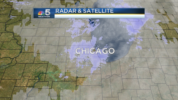
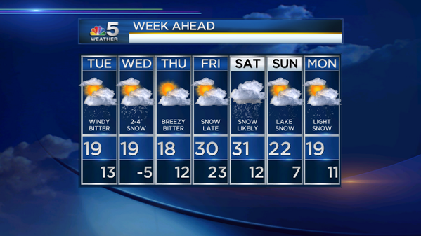
A system that's predicted to dump another two to four inches of snow is headed toward Chicago, and that'll immediately be followed by air that'll bring some of the coldest temperatures we've seen so far this year.
The mercury on Tuesday will struggle to exceed past the teens. Factor in the wind chill and we're talking about temperatures in the single digits and below. Even a moderate break of sunshine later in the day won't raise temperatures all that much.
The next round of snowfall is expected early Wednesday morning, just in time for the morning commute.
That'll likely be out of the area by midday Wednesday, but a blast of cold air will set us up for the coldest night of the year. The air temperature is expected to bottom out Thursday morning from 0 to -10 degrees, and at that temperature, even a slight breeze can easily push the mercury to 20 or 30 degrees below zero.
Make sure your car is prepped for winter weather, your furnace is in good working order and your pets are all indoors. It's going to be brutal.

View image on Twitter


Source: http://www.nbcchicago.com/weather/stories/Chicago-More-Snow-Coldest-Temps-235087281.html#ixzz2n8KKKiSE

Antarctica Sets Record Low Temperature of -135.8 Degrees

Try 135.8 degrees Fahrenheit below zero; that's 93.2 degrees below zero Celsius, which sounds only slightly toastier. Better yet, don't try it. That's so cold scientists say it hurts to breathe.
 
A new look at NASA satellite data revealed that Earth set a new record for coldest temperature recorded. It happened in August 2010 when it hit -135.8 degrees. Then on July 31 of this year, it came close again: -135.3 degrees.
 
The old record had been -128.6 degrees, which is -89.2 degrees Celsius.
 
Ice scientist Ted Scambos at the National Snow and Ice Data Center said the new record is "50 degrees colder than anything that has ever been seen in Alaska or Siberia or certainly North Dakota."
 
"It's more like you'd see on Mars on a nice summer day in the poles," Scambos said, from the American Geophysical Union scientific meeting in San Francisco Monday, where he announced the data. "I'm confident that these pockets are the coldest places on Earth."
 
However, it won't be in the Guinness Book of World Records because these were satellite measured, not from thermometers, Scambos said.
 
"Thank God, I don't know how exactly it feels," Scambos said. But he said scientists do routinely make naked 100 degree below zero dashes outside in the South Pole, so people can survive that temperature for about three minutes.
 
Most of the time researchers need to breathe through a snorkel that brings air into the coat through a sleeve and warms it up "so you don't inhale by accident" the cold air, Scambos said.
 
On Monday, the coldest U.S. temperature was a relatively balmy 27 degrees below zero Fahrenheit in Yellowstone, Wyo., said Jeff Masters, meteorology director of the private firm Weather Underground.
 
"If you want soul-crushing cold, you really have to go overseas," Scambos said in a phone interview. "It's just a whole other level of cold because on that cold plateau, conditions are perfect."
 
Scambos said the air is dry, the ground chilly, the skies cloudless and cold air swoops down off a dome and gets trapped in a chilly lower spot "hugging the surface and sliding around."
 
Just because one spot on Earth has set records for cold that has little to do with global warming because it is one spot in one place, said Waleed Abdalati, an ice scientist at the University of Colorado and NASA's former chief scientist. Both Abdalati, who wasn't part of the measurement team, and Scambos said this is likely an unusual random reading in a place that hasn't been measured much before and could have been colder or hotter in the past and we wouldn't know.
 
"It does speak to the range of conditions on this Earth, some of which we haven't been able to observe," Abdalati said.

Top News Photos of the Week

Source: http://www.nbcbayarea.com/weather/Antartica-record-cold-Ice-235208051.html#ixzz2n8HnFO3J

Chicago Area Faces More Snow, Coldest Temps This Season

The mercury on Tuesday will struggle to exceed past the teens. Factor in the wind chill and we're talking about temperatures in the single digits and below. Even a moderate break of sunshine later in the day won't raise temperatures all that much.
The next round of snowfall is expected early Wednesday morning, just in time for the morning commute.
That'll likely be out of the area by midday Wednesday, but a blast of cold air will set us up for the coldest night of the year. The air temperature is expected to bottom out Thursday morning from 0 to -10 degrees, and at that temperature, even a slight breeze can easily push the mercury to 20 or 30 degrees below zero.
Make sure your car is prepped for winter weather, your furnace is in good working order and your pets are all indoors. It's going to be brutal.

There may be a slight warm up on Thursday before another round of snow, possibly enhanced by Lake Michigan, moves into the area on Friday into Saturday.
The area's first big snowfall of the 2013-2014 season came Sunday, when between three and four inches dumped on the metro area caused airport delays and treacherous driving conditions.
More than 56,000 brave souls faced bone-chilling temperatures on Monday night at Soldier Field to watch the Chicago Bears take on the Dallas Cowboys. The temperature at kickoff was in the low teens and continued to fall from there throughout the game.
View image on Twitter


Source: http://www.nbcchicago.com/weather/stories/Chicago-More-Snow-Coldest-Temps-235087281.html#ixzz2n822SeSF

Storms Power Through Chicagoland Area

The Chicago viewing area had some stormy weather Saturday.
Saturday began quietly enough, but an approaching cold front made things interesting during the late afternoon and early evening hours.
The Storm Prediction Center placed Chicago in the "slight risk" category for severe weather. Stronger showers and thunderstorms were expected to produce some damaging winds and hail
The National Weather Service Issued a Severe Thunderstorm Warning for Cook, DuPage, Lake and Will Counties just before 3:45 p.m. Saturday.
The warnings were prompted by a severe thunderstorm located near Romeoville, Ill. that was moving northeast at 45 mph.
The storm had the potential to cause quarter-sized hail and 60 mph wind gusts, the alert stated.
"You started hearing hail," said Elmhurst resident Nick Pnzio. "the rain was coming down sideways."
Elmhurst residents said the storm didn't last long, but that it packed a punch.
St. Charles Road near Route 83 was closed for several hours Saturday due to high standing water on the street.
Flash flood warnings were also in effect Saturday for Kenosha, Wis. until 10 p.m.
Rain chances stick around Sunday, with temperatures dropping to 62 degrees.
The slow-moving cold front will stick around for a few days, creating rain chances into the start of the week.


Source: http://www.nbcchicago.com/weather/stories/chicago-weather--226294851.html#ixzz2n81Rpcb5

Wet Roads Turn Icy, Dangerous

Monday's wet and cold conditions during the day led to another problem in the evening hours -- icy roads.
The afternoon rain and slushy snow left behind dangerous black ice on area roadways as temperatures dropped into the 20s.
The Palatine and Barrington fire departments were called to several crashes on the Dundee Road Bridge over Route 14. At least two people were injured.
Icy roads also wreaked havoc in Joliet, where 13 cars were involved in a pileup on the Cass Street Bridge shortly after 6 p.m. Two people were transported to local hospitals with minor injuries. Additional crashes involving multiple cars were also reported within that same hour on the Jackson Street, Ruby Street and McDonough bridges.
The outbound Edens Expressway was shut down at Lake Avenue for a time Monday afternoon because of a serious accident involving a motorcycle, and the outbound Stevenson and inbound Kennedy expressways experienced big delays.

Chicago's Department of Streets and Sanitation deployed 45 trucks at 2 p.m. to salt the city's main streets and Lake Shore Drive as well as bridges, hills and overpasses.
The National Weather Service issued a special weather statement warning of icy roads for several suburban areas, and a Lake Effect Snow Advisory for several cities in Northwest Indiana predicted between 3 to 7 inches of snow overnight.
The precipitation was the first official taste of winter for the Chicago area.
Rain showers gradually mixed with snowflakes around noon in Lake and McHenry counties as temperatures began to drop. The rain-snow mix moved into Chicago around 1:30 p.m. and the system continued moving south into Indiana. 


Source: http://www.nbcchicago.com/traffic/transit/Chicago-Could-See-Snow-Next-Week-231131301.html#ixzz2n80k7VN0

Shrinking Arctic Sea Ice Means Scorching U.S. Summers

Thirty years of shrinking Arctic sea ice has boosted extreme summer weather, including heat waves and drought, in the United States and elsewhere, according to a study published Monday in the journalNature Climate Change. 
The new study — based on satellite tracking of sea icesnow cover and weather trends since 1979 — links the Arctic's warming climate to shifting weather patterns in the Northern Hemisphere's midlatitudes.
"The results of our new study provide further support and evidence for rapid Arctic warming contributing to the observed increased frequency and intensity of heat waves," said study co-author Jennifer Francis, an atmospheric scientist at Rutgers University in New Jersey. [Images of Melt: Earth's Vanishing Ice]


European Cities Slow to Adapt to Climate Change, New Study Says

A new study shows that many European cities have no plans in place to help slow climate change or acclimate to its effects. Those that are working toward a climate change fix are, in general, working to slow its pace.
Plans to deal with climate change fall into two categories: mitigation, which addresses the causes of climate change directly (like reducing greenhouse gas emissions), or adaptation, which focuses on strategies to cope with new weather patterns (like building flood barriers to protect cities in the face of rising sea levels).
The new study, led by Diana Reckien of Columbia University’s Center for Research on Environmental Decisions, found that of the 200 European cities examined, 130 — or 65 percent — have at least a mitigation plan, while the remaining 35 percent had neither a mitigation nor an adaptation plan. The team also identified 25 percent of the cities as “climate leaders” for having both types of plans, plus specific targets for reducing greenhouse gas emissions.
“It looks like that for the regular city, the path of development is you adopt a mitigation plan, you start with an adaptation plan and then you get into putting those plans into practice,” Reckien said. “It’s true that there is a lack of adaptation and adaptation engagement.”
The United Kingdom had the highest percentage of climate-leading cities, including London, Manchester and Liverpool, followed by Germany, Finland and France.

Arctic Storms, Warming Temperatures Allowing More Methane To Surface

Underneath the Arctic Ocean sits a large reserve of methane, a potent greenhouse gas. Understanding how much of that is making it to the atmosphere is an important but relatively new area of research. The latest findings published on Sunday in Nature indicate that more could be escaping than previously thought, thanks in part to stormy weather.
The East Siberian Arctic Shelf is a shallow swath of land underneath the East Siberian Sea. It stretches for 2 million square miles and contains large deposits of methane hydrates, which are frozen deposits of highly concentrated methane.
When the hydrates melt, they turn into methane gas, a greenhouse gas that is 25 times more potent than carbon dioxide. Methane hydrates are found throughout the world's oceans but generally under hundreds of feet of water.

Arctic Storms, Warming Temperatures Allowing More Methane To Surface

Underneath the Arctic Ocean sits a large reserve of methane, a potent greenhouse gas. Understanding how much of that is making it to the atmosphere is an important but relatively new area of research. The latest findings published on Sunday in Nature indicate that more could be escaping than previously thought, thanks in part to stormy weather.
The East Siberian Arctic Shelf is a shallow swath of land underneath the East Siberian Sea. It stretches for 2 million square miles and contains large deposits of methane hydrates, which are frozen deposits of highly concentrated methane.
When the hydrates melt, they turn into methane gas, a greenhouse gas that is 25 times more potent than carbon dioxide. Methane hydrates are found throughout the world's oceans but generally under hundreds of feet of water.

For First Time in 20 Years, Cold Records May Beat Warm Records in U.S.

With a large chunk of the U.S. having endured one of the coldest Thanksgiving holidays in years and even more brutally cold weather in the forecast over the next few days, 2013 is poised to have daily record lows outnumber daily record highs for the first time in 20 years.
That’s a stark reversal from last year — the warmest year on record in the U.S. — when record daily highs dwarfed record lows by a staggering 4-to-1 ratio. It’s also a stark reminder of the vagaries of short-term natural variability set against the backdrop of long-term global warming.
According to statistics from the National Climatic Data Center, the U.S. had 9,023 daily record hightemperatures through Dec. 1, compared to 9,932 daily record lows. About 1,000 cold temperature records were set or tied during the last week alone.
Meanwhile, last year at this time, that ratio stood at about 5-to-1 in favor of record daily highs, with 32,232 record daily highs through Dec. 1, 2012, compared to just 6,234 record daily lows during that same period.
So far this year, warm temperature records overall, which includes record warm overnight lowtemperatures, are running slightly behind cold temperature records, with 24,084 warm temperature records set or tied compared to 24,957 cold temperature records.


Top 5 Largest November Tornado Outbreaks

According to our Severe Weather Expert Dr. Greg Forbes, the second half of October, and especially November, can often be a second season for tornadoes and severe thunderstorms.
Forbes says, "In many ways, this is the counterpart to spring, when strong fronts and upper-air systems march across the United States. When enough warm, moist air accompanies these weather systems, the unstable conditions yield severe thunderstorms and sometimes tornadoes."
Most of the time, the second-season tornado outbreaks are in the Gulf Coast states, but they can sometimes spread north to the Ohio Valley and southern Great Lakes.
Below we have a look at the top five worst November tornado outbreaks.

Week-Long Heat Wave for Perth, Western Australia

A strong area of high pressure will build to the south of Western Australia this week promoting a warm offshore flow for much of the state.
This flow will pull unseasonably warm air from the interior of Australia to the west coast of Western Australia, including the capital city of Perth.
The heat wave began on Tuesday as temperatures climb to 32 C (90 F), in Perth.
High pressure will continue to build south of the region right through the middle of the week allowing temperatures to climb. High temperatures around Perth will be near 35 C (95 F) Wednesday and Thursday.
No relief is expected through at least early next week as temperatures will climb to near 37 C (98 F) from Friday through Monday across the Perth Metropolitan Region.

Winter Weather Live Updates: Next Up, Lake-Effect Snow and Alberta Clipper

Behind departing Winter Storm Dion, cold air is triggering lake-effect snows across parts of upstate New York as well as western Lower Michigan and parts of Upper Michigan.

There is also an Alberta clipper that has already brought over 8 inches of snow to the mountains of western Montana. This clipper will bring some very light snow across the Midwest Tuesday night into Wednesday.

http://bcove.me/05mc0bd2

Winter Storm Dion: State-by-State Impacts

Washington D.C., BaltimorePhiladelphia, and New York got roughly 1-3 inches of snow Tuesday morning. Some interior parts of the Northeast received as much as 5 inches. While not major accumulations, the snow fell so quickly in some areas that it created a nightmare on the roads during the morning commute.
"We have about 1.6 inches of snow, officially, at Baltimore-Washington Airport, which is actually more than New York City or Boston has seen this season," said The Weather Channel meteorologist Jim Cantore, reporting from Baltimore.

Rare 7.0 Magnitude Earthquake Strikes Near Falkland Islands

UENOS AIRES, Argentina  -- The U.S. Geological Survey (USGS) says a magnitude-7.0 earthquake has struck in the South Atlantic, southwest of the disputed Falkland Islands.
It says the quake struck at 2:27 a.m. Monday, about 195 miles southeast of the Falklands' capital, Stanley, and 545 miles east of Ushuaia, Argentina. The depth was a shallow 6.2 miles.
The USGS says the quake followed four others that all measured more than 5.0, over a two-hour period leading up to the big quake. It says such quakes are uncommon in the region. Only 15 quakes of more than 5.0 had been measured in the region in the previous 40 years

Rare 7.0 Magnitude Earthquake Strikes Near Falkland Islands

UENOS AIRES, Argentina  -- The U.S. Geological Survey (USGS) says a magnitude-7.0 earthquake has struck in the South Atlantic, southwest of the disputed Falkland Islands.
It says the quake struck at 2:27 a.m. Monday, about 195 miles southeast of the Falklands' capital, Stanley, and 545 miles east of Ushuaia, Argentina. The depth was a shallow 6.2 miles.
The USGS says the quake followed four others that all measured more than 5.0, over a two-hour period leading up to the big quake. It says such quakes are uncommon in the region. Only 15 quakes of more than 5.0 had been measured in the region in the previous 40 years

Britain braces for worst storm in years

(CNN) -- Southern Britain is getting hammered by a major Atlantic storm, which could be its worst in years, and the search for a missing teenager swept out to sea ended for the night with no sign of the boy.
The unidentified teenager disappeared from Newhaven, East Sussex, on the southern coast, according to the Royal National Lifeboat Institution.
Strong winds blew and heavy rains fell late Sunday. Conditions were expected to worsen as the night progresses.
"This weather system is typical of what we expect to see in winter, but as it's coming in during autumn -- when trees are in leaf -- and while the ground is fairly saturated, it does pose some risks. We could see some uprooted trees or other damage from the winds, and there's a chance of some surface water flooding from the rainfall -- all of which could lead to some disruption," said Martin Young, chief forecaster at the Met Office, the UK's national weather service.
Gusts of 60 to 70 mph are forecast in southern parts of England and Wales, with bursts of 80 mph or more in some places.
"While this is a major storm for the UK, we don't currently expect winds to be as strong as those seen in the 'Great Storm' of 1987 or the 'Burns Day storm' of 1990," Young said.
The 1987 Great Storm was responsible for the deaths of 18 people in Britain and four in France. The Burns Day storm left a trail of destruction from the Isles of Scilly to Denmark, killing 100 people, including 47 in the British Isles, according to the Met Office.
The storm could complicate travel conditions Monday morning. The Met Office advised people to take precautions and consider staying off the roads until the worst of the winds has passed.http://www.cnn.com/2013/10/27/world/europe/uk-severe-weather/index.html

Typhoon Haiyan One Month Later: 1,900 Still Missing, 4 Million Displaced

One month after Typhoon Haiyan hit the Philippines, 4 million people remain displaced and it will likely take years for the damaged nation to rebound. That’s according to a new United Nations report tracking response and relief efforts in the typhoon zone.
On Nov. 8, Typhoon Haiyan hit the Philippines with devastating brutality. It ripped homes from foundations and wiped out entire communities. We later learned that Haiyan, or Yolanda as it was called in the Philippines, was one of the strongest tropical cyclones in history.

Latest Statistics from Philippines

Tuesday Snowstorm Slows Travel in Northeast I-95 Corridor

A snowstorm raced across the I-95 Northeast Tuesday sparking travel delays, right on the heels of this past weekend's winter storm.
For a heavily-populated area, this has been primarily snow and a disruptive one at that.
Within minutes after beginning in the northern and western Washington, D.C., suburbs early in the morning, roads became slippery and covered with snow.
Motorists and pedestrians are cautioned Tuesday night to be alert for black ice.