Showing posts with label Elizabeth Harris. Show all posts

Monday, April 27, 2015

Rare Cloud Formations

n unusual cloud formation rolled over the Statesboro area Monday morning, prompting a social media buzz as users posted photos, questions and comments about it.
The odd cloud formations, unofficially named "undulatus asperatus," seemed to roll, wave or undulate across the sky around 10:15 a.m. In fact, the Cloud Appreciation Society hopes undulatus asperatus will become the newest cloud classification - the first in 50 years.
"This is the second time in two weeks that we have seen these clouds," said Carl Burns, meteorologist with the National Weather Service's Charleston office. "They are rare, not something we deal with a lot."
Undulatus asperatus clouds usually signify a stable weather pattern that is disturbed by something, and the clouds do not mean rain or rough weather is on the way, although they appear ominous and disturbing, he said.
According to meteorologynews.com, "Turbulent motions between differing air masses create undulating clouds." They are more common in the Plains states and "are not considered a precursor to severe weather."
The strange cloud formation only recently has been under consideration as a new, scientific classification of cloud. Gavin Pretor-Pinney, founder of the Cloud Appreciation Society, has campaigned to get the cloud recognized as an official formation for years, and cloud enthusiasts have been appealing to the World Meteorological Organization in Geneva for scientific recognition, according to slate.com.
If the Cloud Appreciation Society is successful, undulatus asperatus will be the first new cloud formation to be recognized since 1951, when "cirrus intortus" necessitated a reprint of the International Cloud Atlas.
As Statesboro saw Monday morning, undulatus asperatus clouds have a rough underside that resembles a choppy sea when viewed from underwater, which is why the Latin name translates, approximately, to "roughened or agitated waves." It makes for a dramatic, turbulent skyscape that seems to herald nasty weather but usually dissipates without any storms.
According to weather.com, the clouds "occur when enough atmospheric instability, or rising air, is available to create widespread cloud cover, as well as wind shear and turbulence, which creates the wavy, rough sea-like visual effect."
"There were showers and thunderstorms approaching the area from the west at the time," according to accuweather.com meteorologist Alex Sosnowski. "The air was dry near the ground but was increasingly moist aloft as the storms and rain approached."
The cloud formations were seen over Georgia and South Carolina Monday morning. Bulloch County Public Safety Director Ted Wynn captured images of the clouds around 10:15 a.m. as they swept across Statesboro's sky, as did many other residents, fascinated by the unusual sight.
"They are fairly rare ... and seldom are seen in our neck of the woods," said Savannah meteorologist Lee Haywood.

 http://www.statesboroherald.com/section/1/article/66803/

 Rare cloud formation waves over Statesboro

Lightning Causes Fires In Conneticut

Wild thunder rumbled and vivid lightning lit up the skies in Connecticut early Tuesday morning, sparking some fires and causing power outages.
The Burlington fire marshal is investigating whether the storm played a factor in a fire that destroyed a barn and a 1999 Porsche on Punch Brook Drive. (Bad Luck)
A stove fire on Tuesday morning that caused minor damage at 24 Rossi Road in Torrington might have been related to the storm, officials said.
Lightning also struck a chimney at 52 Deepwood Drive in Madison Tuesday morning, but didn't cause much damage. Fire crews responded, but cleared the scene quickly.
There were hundreds of outages on Tuesday morning, including to 512 United Illuminating customers in East Haven and 100 in Manchester, but much of the power has been restored.

 http://www.nbcconnecticut.com/news/local/Thunder-and-Lightning-Storm-Causes-Outages-Fires-300766271.html


Chile Volcano Ash Cloud Bears Lightning

A volcano in southern Chile has erupted for the first time in more than five decades, sending a thick plume of ash and smoke more than 12 miles into the sky.
These incredible pictures lay bare the awe-inspiring power of Mother Nature and capture the erupting volcano engulfed by a lightning storm, the snake-like bolts crackling around the billowing cloud.
Chile's Onemi emergency office declared a red alert following the sudden eruption, the first since 1972, of Calbuco last night, which occurred about 625 miles south of Santiago, the capital, near the tourist town of Puerto Varas.

As night fell, about 4,000 people had so far moved out of the area and an evacuation radius of 12 miles has been established, authorities said.
President Michelle Bachelet is scheduled to travel to the affected area on Thursday.
Getty Calbuco volcano
Fire in the sky: A high column of ash and lava spewing from the Calbuco volcano
There are no reports of deaths, missing persons or injuries, Interior Minister Rodrigo Penailillo said. He urged residents to evacuate and warned of possible lahars, a mix of water and rock fragments that flow down a volcano's slopes and river valleys.
Winds blowing northeast were pushing the column of ash and smoke toward Argentina.

 http://www.mirror.co.uk/news/world-news/chile-volcano-breath-taking-images-show-5566457

Georgia Strait Waterspout

Davis Bay resident Denys Carrier was eating dinner Thursday night around 6 p.m. when he looked west toward Parksville and saw a rare sight in the Strait of Georgia – a waterspout.
The tornado-like column of water stretched to the clouds as Carrier snapped a series of photos, then it disappeared.
“It was quite amazing,” said Carrier. “The sun came out at the same time, which made the pictures quite beautiful."
It was the first time Carrier had seen a waterspout since he moved to Davis Bay - located south of Sechelt on the Sunshine Coast - in 2006.
There are two types of waterspouts, according to the U.S. National Ocean Service: fair weather and tornadic waterspouts.
Advertisement
Fair weather waterspouts start on the surface of the water and work their way upward. Tornadic waterspouts reach down from thunderclouds and are usually accompanied by lightning, high winds and hail, according to the service.

Rare waterspout spotted in the Strait of Georgia

Everest Shows Ferocity of Avalanche

It’s early Monday morning now in Nepal, a day and a half after the earthquake. Sunday—12 hours ago—dawned clear as rescuers had hoped. Helicopters began landing in Base Camp just after first light. I spoke briefly with Under Armour director of innovation Nick Cienski, who was climbing the mountain with HimEx and who is still in Base Camp after helping recover bodies and stretcher the injured to the makeshift medical facility at International Mountain Guides’ base. According to Cienski, 50 injured people were evacuated by helicopter, 21 of them in critical condition. There are 18 people confirmed dead, most of them Sherpas. By late afternoon the weather closed in again, and the rescue flights had to stop.
At this point, the upper portion of Base Camp looks like the natural disaster area that it is. Sleeping tents have been blown away, chairs and tables scattered across the moraine, and the tattered skeletons of mess tents stand stripped bare of their fabric by the hurricane-force winds that raced ahead of the avalanche.
According to an email from a New Zealand–based Adventure Consultants staffer, all patients were initially shuttled to Pheriche, at 14,000 feet, and then by a larger Russian cargo helicopter to Lukla or Kathmandu.
“We know our injured Sherpa are in both the Kathmandu Medical College and another clinic in Kathmandu,” wrote Adventure Consultants operations manager Caroline Blaikie. “We have also heard reports from our Mera Peak group of the Lukla hospital taking patients from Everest Base Camp.”
Cienski confirmed that the Himalayan Rescue Association (HRA) took a direct hit and was completely wiped out. The HRA camp houses the legendary Icefall Doctors who set and maintain the route through the Khumbu Icefall. Three of the Icefall Doctors were killed, and more were injured. Since no thorough, camp-wide count has yet been conducted, the total number of dead and missing has not been firmly established. It’s still possible that there are climbers buried at Base Camp and in the Icefall. According to International Mountain Guides founder Eric Simonson, who is in contact with his team on the mountain, a helicopter pilot was scheduled to make a careful inspection of the route through the Icefall Sunday morning. A more accurate count of the missing should emerge within the next 12 hours.
The news that the Icefall Doctors are out of commission also makes the situation more tenuous for the climbers trapped in Camps I and II, who until now had planned to descend under their own power. I don’t have an exact count of who is above Base Camp, but the list includes groups from Alpine Ascents International (AAI), Madison Mountaineering, Adventure Consultants, International Mountain Guides, and Rainier Mountaineering. Madison has posted an accounting of the whereabouts of its climbers. Madison Mountaineering’s Base Camp manager Kurt Hunter estimated that the number of climbers above Base Camp was between 100 and 120. 

https://www.outsideonline.com/1972696/aftermath-everest

Scorched Las Angeles

Ten threatened homes were briefly evacuated before firefighters surrounded a wildfire that burned in a heavily populated suburban neighborhood of Los Angeles.
Some 200 firefighters with help from water-dropping helicopters had the blaze contained about 90 minutes after it broke out San Fernando Valley community of Granada Hills.
Heavy flames burned on a hillside near a mansion with a swimming pool and tennis court where a line of firefighters sprayed water to protect it.
No homes or other structures were damaged and no one was been injured.
Fire officials said the neighborhood had done an excellent job of clearing brush around homes and that helped keep the fire in check.
 Wildfires are common in California, but with the intense drought occuring, much of the vegetation is easily combustible, and water ponds used by Helicopters to fill up are becoming empty and running out. This can create serious issues in future firefighting.

 http://www.sacbee.com/news/state/california/article19755084.html


Read more here: http://www.sacbee.com/news/state/california/article19755084.html#storylink=cpyhttp://www.sacbee.com/news/state/california/article19755084.html


Sydney Hail Storm

A rather rare occurance took place in Australia on the 25th, as a hail storm caused damage to hundreds of Sydney facilities and buildings.
Landlords are counting the cost of the damage to their properties across the city, which will reach the millions, following the hail storm that ripped through Sydney on Saturday.
Goodman Group's Bungarribee Industrial Estate at Huntingwood in Sydney's west was the hardest hit with its roof collapsing.
A spokesman for Goodman confirmed that two of its facilities had been damaged, but all staff were unharmed.
Advertisement
"It seemed to hit that corridor with intensity, but we cannot comment as we are currently assessing the full impact," the spokesman said.
"There isn't the same level of damage that Sydney saw in 1999, but we won't know anything more until we can get into the property, and talk to our customers about any relocations plans."
It was understood that no major damage was reported for properties owned by DEXUS or Stockland, but some smaller warehouses around South Sydney and the western areas will be mopping up when they return to work on Monday.
Property agents said the storm was not as devastating as the April 1999 one, but it will still lead to tenants looking to relocate as they assess the damage.

 http://www.smh.com.au/business/property/hail-storm-wreaks-havoc-to-sydney-warehouses-20150426-1mtgn1.html

 The freak hail storm hits Petersham on Anzac Day.

Louisiana Tornado

Officials at the National Weather Service confirmed that a tornado touched down Monday morning in Kenner. According to the NWS website, the tornado struck Kenner around 10:30 a.m. near West Esplanade Avenue and Loyola Drive.The NWS said crews were sent to investigate in Kenner and confirmed that an EF1 touched down in the community west of New Orleans. Multiple trees and power poles uprooted, snapped or bent over," the NWS website described.
Elsewhere in the area, minor roof damage was visible to several homes. The roof of a patio was also reportedly lifted off one home.
While the report is still preliminary, the NWS said the EF1 tornado winds reached 90 mph. It traveled for 0.5 miles at a maximum width of 50 yards when it touched down.
Further details are expected this week.  While the Tornado was smaller in size, its winds were able to inflict damage on the town, and certainly left inhabitants rattled.

http://www.wdsu.com/news/local-news/new-orleans/nws-confirms-ef1-tornado-touched-down-in-kenner-monday-morning/32606406

Brazilian Drought

The current drought in southeastern Brazil, the richest, most densely populated region in the country, has created the greatest water shortage in the last 85 years and could last for 30 more years, a meteorologist said Saturday.
The meteorologist and partner-director of the consultancy Somar Meteorology, Paulo Ethichury, told Efe that the South American country's current climate follows a cooling cycle in the Pacific Ocean during recent years, which came after the 1980s, 1990s and 2000s, when it was warmer.
Agribusiness was frightened by the climate at the beginning of this year, with delays in the soybean crop and lower production levels forecast for other agricultural products like coffee.
According to Ethichury, longer periods of drought could be repeated next year.
"The current phase is the same we went through in the 1940s, when there were also smaller volumes of rain. This is a new cycle, in which we're returning to the dry phase," according to the specialist, for whom weather cycles tend to last a period of 30 years.
The water crisis in the southeast has alerted the states of Rio de Janeiro, Minas Gerais, Espirito Santo, and principally, Sao Paulo, the richest, most densely populated in the country.

The water crisis in the southeast has alerted the states of Rio de Janeiro, Minas Gerais, Espirito Santo, and principally, Sao Paulo, the richest, most densely populated in the country.
The Cantareira dam system, which supplies 6.5 million people - a third of the Sao Paulo metropolitan area - has already consumed twice the so-called "dead volume," an additional reserve for the reservoirs.
The rains of February and March, despite having been heavier than the average for those months, were not sufficient to improve the situation.
Meanwhile the president of the state-run agricultural research company Embrapa, Mauricio Antonio Lopes, said that drought has sparked the introduction of new technologies and the production of genetically modified organisms, or GMOs, in the country.
"We're incorporating technologies that will make our agriculture more able to withstand the lack of water," Lopes told the daily Folha of Sao Paulo in an interview

 http://latino.foxnews.com/latino/news/2015/04/04/brazilian-drought-could-last-30-more-years-meteorologist-says/

 Image result for brazilian drought 2015

Kentucky Drowned In Flooding

Kentucky and other parts of the South and Midwest faced massive flooding as severe rainfall and thunderstorms battered the region starting Thursday night. Torrential rains overnight caused major flash flooding in Louisville, Kentucky, where roads were closed Friday, schools were closed and more than 160 water rescues took place.
Stretches of interstates were closed in Indiana and Kentucky due to flooding, as well. A UPS driver had to be rescued by firefighters in a ladder truck in Indiana, where his truck was stranded on Interstate 60. A school bus with 16 students on board was stranded for three hours in floodwaters in northern Kentucky before it was rescued.
One fatality was reported in Powell County, Kentucky, on Friday. A 45-year-old woman was camping with her family at Middle Fork Campground when a dead tree was blown onto the family's tent, killing the woman and injuring her husband.
Tornadoes also were reported in the Plains and the Midwest. One occurred in Joplin, Missouri, which was struck by a deadly tornado in 2011 that killed more than 150 people. The National Weather Service was also investigating reports of a tornado touching down in Ottawa County, Oklahoma. 
The National Weather Service issued a tornado watch for Tennessee, Kentucky, southern Indiana, southern Illinois, southeastern Missouri and northeastern Arkansas until 9 p.m. CDT.

http://www.ibtimes.com/severe-rainfall-flash-floods-tornadoes-batter-kentucky-other-parts-south-midwest-1869536

RTR4W1JP

Uprooted trees, floating houses, wrecked boats and flash floods in deadly NSW storm

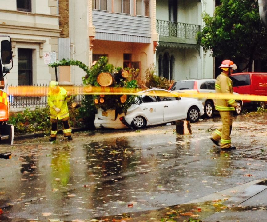
The brutal storm that has killed three people in New South Wales today is set to worsen tonight.
Residents in the Newcastle region have been warned via text messages from authorities to prepare for flash flooding and heavy rains.
Earlier today a Newcastle resident in Merewether Heights captured the moment a huge gum tree toppled over in strong winds.
In Dungog, where two elderly men and an elderly woman were found dead, residents have been told to evacuate after raging flood waters swept through the area.

Earlier today dramatic footage emerged of a house floating down a street in Dungog, where more than 312mm of rain in 24 hours was recorded.
The east coast low is expected to pound NSW for another 12 hours before easing on Wednesday morning.
The SES has described the weather conditions as the state's worst in five years.
"This is going to be catastrophic today," SES Deputy Commissioner Steve Pearce told Macquarie Radio.
More than 20 people have been rescued from floodwaters, 10 of them from rooftops in Stroud, just north of Newcastle.

Waves of up to 11m have been reported off Sydney's coast and more than 4000 calls have been made to SES over the past two days.
"There have been multiple persons trapped in vehicles, being trapped in buildings and being trapped on top of buildings while trying to take refuge from floodwaters," Mr Pearce said.
More than 100 NSW schools have been closed and gates closed at national parks as a severe weather warning continues for Sydney, the Hunter and the Illawarra.
A cruise ship is stuck outside Sydney Heads because of a massive swell - and it may be there for the next 48 hours.

 http://tvnz.co.nz/world-news/uprooted-trees-floating-houses-wrecked-boats-and-flash-floods-in-deadly-nsw-storm-6295681

 Embedded image permalink

Nepal Avalanche

A devastating 7.8 magnitude earthquake that struck Nepal on Saturday killed more than 2,000 people, left a wake of destruction across the broader region, and triggered a deadly avalanche on Mount Everest.
As rescue crews raced to find survivors, the death toll steadily rose. On Sunday afternoon, Nepal police said that more than 2,200 people were killed.
The earthquake, the worst to hit Nepal in over 80 years, also triggered a deadly avalanche on Mount Everest.
The avalanche buried part of the mountain's base camp, which was full of mountaineers who had come for the start of the main climbing season. Alex Gavan, a climber who said he was at base camp, wrote on Twitter: "Running for life from my tent. Unhurt. Many many people up the mountain."
An army spokesman told Reuters that at least 18 bodies had been found on Mount Everest. Google executive Dan Fredinburg was among those killed in the avalanche, CNN reports.
Powerful tremors also rocked neighboring countries, killing 34 in northern India, six in Tibet and two in Bangladesh, as well as two Chinese citizens on the Nepal-China border.
The earthquake's epicenter was 50 miles east of Nepal's second-largest city, Pokhara. Geoscientists noted that the shallowness of the quake amplified the power of its tremors at the surface, adding to the destruction.
Strong aftershocks continued throughout the afternoon, as rescue teams scoured the rubble for survivors.

 http://www.huffingtonpost.com/2015/04/25/nepal-earthquake-avalanche_n_7141944.html

 earthquake

China's Great Wall of Trees

China is the world’s largest emitter of greenhouse gases, but it is also engaged in a massive tree-planting program that has helped to offset tropical deforestation, and suck some of the climate-changing carbon dioxide out of the atmosphere.
Reforestation efforts in China, combined with regrowth on abandoned farmland in Russia, have helped offset 81% of the loss in above-ground biomass carbon lost to tropical deforestation since 2003, according to a new study in the academic journal Nature Climate Change. 
“The increase in vegetation primarily came from a lucky combination of environmental and economic factors and massive tree-planting projects in China,” said lead study author Yi Liu of Australia’s University of New South Wales. Liu said that the carbon storage in Chinese forests increased by about 0.8 billion tons (0.72 billion tonnes) between 2003 and 2012.
Analyzing two decades worth of satellite data, researchers found that the amount of carbon absorbed in vegetation had increased by about 4 billion tons since 2003, even as tropical forests have shrunk in Indonesia and Brazil, and pest infestations and wildfires have cleared forests in Canada and the United States.
Increases in above ground biomass carbon (in blue) can be seen in Russia, China, southern Africa, and northern Australia.("Recent reversal in loss of global terrestrial biomass," Nature Climate Change.)
In contrast, southern Africa, northern Australia, and parts of Russia have seen increases in vegetation, helped by more rainfall and higher levels of CO2 in the atmosphere, which helped plants grow “more vigorously,” according to the study. In China, most of the vegetation increase has been in the north, where the country has focused its main reforestation efforts, along with some additional growth in the southeast, Liu said.
Observers say China’s reforestation program in the north—also known as the “Green Great Wall”—is the world’s largest ecological engineering project. The country is building a belt of trees that will stretch some 2,800 miles across north and northwest China in an attempt to stop the advance of the Gobi desert. Overall, the country has planted 13 million hectares (32 million acres) of new forest since 2008, according to the State Forestry Administration.
Critics of China’s plans note that net tree cover continues to fall in the country. That’s due in part to the fact that many of the new trees are non-native fruit and rubber tree plantations that require large amounts of water, and are monocultures prone to disease and pests. According to Global Forest Watch, China has been suffering a net loss of about 523,248 hectares (1.29 million acres) of tree cover a year since 2011. Since 2008, that yearly amount appears to be dropping.

 http://qz.com/391797/china-is-building-a-great-wall-of-trees-to-fight-climate-change-and-the-encroaching-gobi-desert/

Chicago: The Snowy City?

The 19.3 inches of snow recorded at O'Hare ranks the storm as the fifth largest snowfall Chicago has seen, beating a March 1930 storm by one-tenth of an inch.
The city's biggest blizzard happened in 1967 when 23 inches of snow fell on Jan. 26 to 27. The second-biggest blizzard happened in 1999 when 21.6 inches fell. The third-largest storm was in February 2011, when the weather service recorded 21.2 inches of snow and the fourth-biggest storm was in January 1979 when there was 20.3 inches of snow.
The storm, with its steady snowfall and gusty winds, dropped visibility to less than one-quarter of a mile. It caused a myriad of problems for those trying to get around, prompted some businesses and city attractions to close early on a Super Bowl Sunday, and forced Chicago Public Schools officials to cancel Monday classes.
"This level of snowfall will present many challenges for our children," CPS CEO Barbara Byrd-Bennett said a Sunday evening statement. "The safety and well-being of our students always comes first."
The Chicago Transit Authority on Sunday evening rerouted buses that use Lake Shore Drive to nearby neighborhood streets. The main artery along Lake Michigan remained opened to all other drivers, however.
"The only issue we may or may not have with Lake Shore Drive today that we're watching is the wind," Streets and Sanitation Commissioner Charles Williams said during a midday Sunday press conference. "You have a strong wind coming off the lake. That could hit Lake Shore Drive with some flooding but we're watching it. Up to this point, it has not been a problem."
Williams said more than 350 pieces of snow-fighting equipment were out trying to maintain clearance on the city's main thoroughfares, including Lake Shore Drive.
Attention would turn to the city's side streets on Monday once the snow stopped falling, he said.
Aside from the roadways, Williams stressed the need for business and property owners to ensure walkways and sidewalks are cleared of snow as often and as quickly as possible. Volunteer shovelers may be available for those who can't do the work. The elderly and disabled residents can call 311 to see if a volunteer shoveler is available.
Dogs in the Snow Dogs in the Snow

Wildfire Season has Become Year-long

“Wildfire season” seems to be a thing of the past for drought-stricken California, with fires now raging throughout the year.
There have already been nearly 850 wildfires this year — 70 percent above the average, according to CAL FIRE data. High temperatures and low precipitation, both related to climate change, have dried out forests and scrublands across the western United States, allowing fires to spread faster and farther than usual, any time during the year.
“Since 2000 we’ve been seeing larger and more damaging fires,” Daniel Berlant, chief of public information for the California Department of Forestry and Fire Protection (CAL FIRE), told NBC News. “What we’re seeing now is that the rain is starting later and stopping much earlier. The fires are burning at explosive speed because the vegetation is so dry and that allows them to get much larger.”
In February, residents were shocked by a fire that destroyed 60 homes at the base of the Sierra Nevada range, in eastern California.
“Three years before, I had 12 feet of snow at my house on that exact date in February,” volunteer Fire Chief Dale Schmidt told the San Jose Mercury News. “Four years ago, they would have had a couple to 3 feet of snow where the fire started.”
Snowpack is a key source of water for California, and it is now at a historic low. In fact, even the ponds where firefighters fill up their helicopters have run dry.
“Because of the drought we are having to locate other water sources for our aerial program. Some of the holding ponds in central California are just not there anymore. So we have to plan prior to the fires where the helicopters can go to fill up,” Mike Mohler, a fire captain with CAL FIRE, told NBC News.
This all fits in with the scientific community’s consensus on climate change. The U.S Global Change Research Program — headed by the National Oceanic and Atmospheric Administration and backed by the Department of Defense, the Department of Energy, NASA, and the Smithsonian Institute among others — says there will be “more frequent heat waves, extreme precipitation, wildfires, and water scarcity” due to climate change.
Firefighters are seeing the climate change effects firsthand. The drought and higher temperatures are not only increasing the likelihood of fires, they are making fires worse, experts say.
“Five years ago without a drought in California you would still get wildland fires. But the vegetation wouldn’t burn as quickly. Now there’s zero moisture and you get explosive fire growth,” Mohler said.
The increased numbers and severity of fires is also taking a toll on the state’s finances. On top of the $209 million included in the state budget for firefighting, Gov. Jerry Brown has authorized an additional $113.7 million in emergency funds this fiscal year, which ends in June.

The record wildfire year is already beginning to startle Californians who's state is already plagued with firs issues. The water necessary to fight the fires isnt available, due to the drought currently dehydrating the Celebrity state.

 http://thinkprogress.org/climate/2015/04/26/3650923/californias-wildfire-problem/

California's firefighters are bracing for a long summer.

Australian Ozone Depletion Causes Increase in Skin Cancer

Australians suffer the highest rates of skin cancer in the world. Each year, around 1,200 Australians die from what is an almost totally preventable disease. Everyone can develop skin cancer; however, some people may be at higher risk than others, due to a range of factors.

Ultraviolet (UV) radiation levels in Australia are higher than in Europe, even during summer. Being located close to the ozone hole over the Antarctic means much higher, more severe levels of UV radiation get through to ground level. This increased radiation from UV rays leads to pigmentation issues, which can lead to melanoma

During summer, the earth's orbit brings Australia closer to the sun than Europe during its summer, resulting in an additional seven percent solar UV intensity. This, coupled with our clearer atmospheric conditions, means Australians are exposed to up to 15 per cent more UV than Europeans.


Australian media has directly addressed the issue, to the point where they have cartoon commercials that remind people to apply sunscreen.

 http://www.theozonehole.com/australianskincancer.htm

Ozone Depletion Over Antartica

The Antarctic ozone hole is a dramatic thinning of ozone in the stratosphere over Antarctica each spring. This damage is due not only to the availability of ozone-depleting substances in the stratosphere, but also specific meteorological conditions that facilitate the destruction of ozone over Antarctica.
The ozone holes in 2000 and 2006 were the largest on record, measuring around 29.8 and 29.6 million square kilometres respectively (more than three and a half times the size of Australia), and at times extended over populated areas.
The 2002 and 2004 ozone holes were much smaller, due in large part to the disruption of the hole by other weather conditions in the troposphere and stratosphere.
Prospects for the long-term recovery of the ozone layer are good. Non-essential consumption of major ozone depleting substances ceased for developed countries in 1996, and for developing countries in 2010.
Scientists predict that if the international community continues to comply with the Montreal Protocol, the ozone layer should recover to pre-1980 levels between 2050 and 2065.
While these repairs and natural reconstruction of the ozone are definitely a good thing, the expected dates are far ahead of us, and the final result isn't even the natural level of ozone depletion.

http://www.environment.gov.au/protection/ozone/ozone-science/ozone-layer

Antarctic Ozone Home TOMS ozone image 1979

2011 Tsunami Repurcussions

The 2011 tsunami that struck Japan released thousands of tons of ozone-destroying chemicals and greenhouse gases into the air, a new study shows.
Thanks to the country's strict building codes, the enormous magnitude-9 Tohoku earthquake left Japan's homes and businesses relatively untouched. But the earthquake triggered a deadly tsunami that roared through coastal cities and villages, destroying almost 300,000 buildings, according to the National Police Agency of Japan.
The damaged insulation, refrigerators, air conditioners and electrical equipment unleashed 7,275 tons (6,600 metric tons) of halocarbons, the study reported. Halocarbon emissions rose by 91 percent over typical levels in the year following the earthquake, said Takuya Saito, lead study author and senior researcher at the National Institute for Environmental Studies in Tsukuba, Japan. [In Pictures: Japan Earthquake & Tsunami
 These halocarbons add to and help accelerate global warming, especially considering that their levels have risen 34 percent in a single year. These gasses have been banned for over 15 years because of the understood detrimental effects it has on our environment. In fact, Japanese ecologists expressed bewilderment towards the evidence showing the immense increase caused by the tsunami.

 http://www.livescience.com/50371-japan-tsunami-released-ozone-destroyers.html

 An aerial view of damage to Sukuiso, Japan, a week after the earthquake and subsequent tsunami devastated the area in March, 2011.

Hail Storms in Texas

A severe storm system that swept across parts of Texas over the weekend brought numerous reports of tornadoes, damage to buildings, large hail and several inches of rain, the National Weather Service said Monday.
The weather service's Forth Worth office said it had received reports of twisters in rural Johnson and Hill counties but hadn't yet confirmed them.
Some homes and other buildings were flattened in the aftermath of the storm Sunday while other structures had their roofs torn away or were damaged by falling trees. There were no accounts of injuries.
Hail described as the size of ping pong balls, and larger, showered the area.
National Weather Service forecaster Lamont Bain said Monday that severe weather reached Comanche, Erath, Somervell, Bosque, Hill and Johnson counties. He said Glen Rose received more than 4 inches of rain.
Part of the Waxahachie police headquarters south of Dallas flooded as water several inches deep rushed into the building.
Videos and photographs depict incredible masses of ice ranging in size from a golf ball, to bigger than a softball. Incredible amounts of damage were caused.

http://www.foxnews.com/us/2015/04/27/twisters-reported-as-part-severe-texas-storm-system-that-brings-damage-to/

Texas Storms-1.jpg

Moore: The Heart of Tornado Alley

The 1999 twister that struck Moore, Oklahoma, part of a 74-tornado outbreak pulverized entire neighborhoods with winds reaching 318 miles per hour, the strongest ever recorded on Earth. In 2013, a 2-Mile-Wide tornado tore down almost the exact path as its 1999 predecessor, and resulted in catastrophic damage to the town.
Meteorologists say it's extremely rare for any town to get hit twice by killer tornadoes. Why does Moore have such terrible luck? A brief guide:
Why is this part of Oklahoma so vulnerable to killer tornadoes?
The short explanation is that Moore sits at the heart of Tornado Alley. Tornado Alley extends from the Rocky Mountains in the West to the Appalachians in the East. Seventy-five percent of the world's tornadoes hit in the U.S. That's more than 1,000 per year. (Canada, at No. 2, has just 100 per year.) And nowhere are they more common than in the swath of the nation's midsection centered around Texas, Oklahoma, Kansas, and the states to the north.
What makes tornadoes so common there?
The Rockies block moist air from flowing eastward. This clears the way for frigid Arctic air to stream south from Canada over the Great Plains. These cold blasts then run into warm, humid air coming up from the Gulf of Mexico. When these cold and warm air masses collide, they cause powerful rotating updrafts and downdrafts that can create dangerous thunderstorms known as "supercells," which in turn spawn powerful tornadoes.

 http://theweek.com/articles/464148/why-tornado-alley-prone-disaster