Showing posts with label Gustavo Lopez. Show all posts

Monday, December 2, 2013

Tropical Storm Melissa Recap

Tropical Storm Melissa was the thirteenth named storm of the 2013 Atlantic hurricane season.
On Monday, Nov. 18, 2013, Melissa began as a "subtropical storm," a sort of hybrid between a tropical and mid-latitude storm system. Over time, it developed a tighter core of convection (thunderstorms) close to its center, which led to Melissa's transition into a fully tropical storm on Wednesday Nov. 20, despite being centered north of 35 degrees North latitude—about the same latitude as Charlotte, N.C.
On Thursday, Nov. 21, Melissa became a post-tropical low. Although it was never a serious threat to land, Melissa did cause some gusty winds over the Azores.Amazing Hurricane Images: Isabel - 2003 (NASA)

Hurricane Season 2013: Least Active Since the 1990s

The 2013 Atlantic hurricane season was the least active season so far this century, and among the quietest on record since 1950.
2013 Atlantic Tracks
Tracks of named tropical storms and hurricanes in the 2013 Atlantic hurricane season.
ACE index by season
Graph of Atlantic Basin ACE index by year from 1970-2013. The 2013 total is highlighted in red at the far right. (Credit: Weather Underground)
While the total of 13 named storms was one more than the 30-year average of 12 named storms, that doesn't tell the whole story.
A better method of summing up hurricane season activity than simply counting storms utilizes the Accumulated Cyclone Energy, or ACE, index. This is calculated by adding each tropical storm or hurricane's wind speed through its life cycle. Long-lived, intense hurricanes have a high ACE index. Short-lived, weak tropical storms, a low ACE index. Summing up the ACE indices of each storm or hurricane will give you an ACE index for the entire season.
The bar graph at right from Weather Underground shows just that. Notice the paltry ACE index of 33 in 2013.
Since 1950, there were only five other hurricane seasons less active than 2013:
That stretch from 1982-83 was one of the strongest El Niño events on record. Increased wind shear during stronger El Niño events tends to suppress tropical cyclone development. Indeed, only 10 named storms formed during the 1982 and 1983 seasons, combined, though one was destructive Hurricane Alicia. In 2013, the equatorial Pacific was in a neutral state, neither El Niño, or its opposite, La Niña, was in play.
An average season's ACE index is about 110. Hurricane Ike in 2008 had an ACE index of 39, more than the entire seasons of 2013, 1983 and 1982.
(MORE:  Weather Underground ACE Page)
Only two Atlantic Basin storms strengthened to hurricanes in 2013, Humberto and Ingrid. Humberto pushed the record for the latest first Atlantic hurricane of the season, waiting until Sept. 11. Ingrid became a hurricane in the far western Gulf of Mexico before sliding into eastern Mexico.
Furthermore, there was not a single major hurricane, Category 3 or stronger on the Saffir-Simpson hurricane wind scale, this season. According to Digital Meteorologist Chris Dolce (Twitter), the last season lacking a single major Atlantic hurricane was 1994.
(MORE:  Hurricane Season By The Numbers)
Eight of the season's 13 named storms eventually succumbed to either dry air, strong wind shear or both. This includes each storm forming in the central and eastern Atlantic Ocean, as well as Tropical Storm Karen.

Monday, November 18, 2013

Severe Weather Taking a Break Early This Week

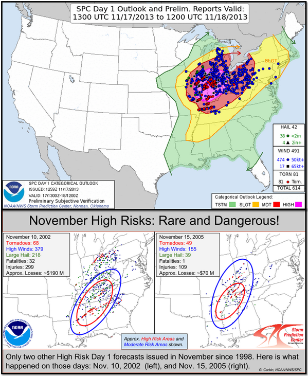
A powerful storm system brought tornadoes and widespread damaging wind gusts to the Midwest Sunday, and strong straight-line wind gusts to the Northeast Sunday night into early Monday morning.
(RECAPS: News Updates | Photos)
Monday, the cold front will have swept out to sea, except for parts of the Southeast coast and Florida, where scattered non-severe thunderstorms may flare up in the lingering warm and humid air.
Tuesday, scattered thunderstorms may rumble again over South Florida, but should remain non-severe.
Below you will find our live updates ticker with the latest updates and breaking information on Sunday's outbreak, including damage surveys, as well as information on any of Monday's thunderstorms in the Southeast.

Severe Weather Live Ticker: Latest Updates

All tornado warnings, along with other relevant tweets from The Weather Channel and local National Weather Service offices in current threat areas, will appear here.  Information updates automatically; no need to reload or refresh your browser. Time stamps on the left are in Eastern time; subtract one hour for Central time and two hours for Mountain time. For complete warning information and radar links, look below our live ticker.

Subtropical Storm Melissa Forms in the Atlantic Ocean

Subtropical Storm Melissa has formed in the central Atlantic Ocean about 700 miles east of Bermuda. It is expected to lift north and then northeast over the next several days with a slight increase in intensity. Melissa is no threat to land
Melissa is the 13th named storm and 14th tropical cyclone of the 2013 Atlantic hurricane season.

What's in a Name?

The only previous Atlantic storm named Melissa was in 2007; it was a weak tropical storm west of the Cape Verde Islands. It too never menaced any land areas.
"Melissa" replaced "Michelle" on the six-year rotating list of storm names after Hurricane Michelle slammed Cuba as a Category 4 storm on Nov. 4, 2001, causing its name to be retired by the World Meteorological Organization.
Previously, "Melissa" was the name of a super typhoon in the western Pacific Ocean in 1994. That cyclone also made no landfalls, but its peripheral effects killed three people in Japan.
Below, we have the latest details on Subtropical Storm Melissa.

Projected Path

Monday, November 11, 2013

Tropical Depression Zoraida Lurks as Haiyan Relief Continues

A tropical depression, named Zoraida by the Philippine weather agency PAGASA, is approaching the east coast of Mindanao, the largest island in the southern part of the Philippines. As of 4 a.m. Tuesday local time (3 p.m. EST Monday in the U.S.), Zoraida was centered about 120 miles east of Davao City.
Davao is one of the largest cities in the Philippines, with over 1.4 million people in the city and 2.2 million people in its metropolitan area.
Background

Philippines Satellite

Philippines Satellite

Philippines Satellite

Philippines Satellite
While winds are currently weak with this system and only minor intensification is expected, the rainfall that comes with it will be unwelcome, particularly if it nudges north into the central Philippines where Haiyan (known in the Philippines as Yolanda) dealt its worst blow. Zoraida is moving in a west-northwesterly direction, so the greatest impacts should remain across the southern Philippines.

Typhoon Haiyan Update: Little Aid Has Arrived in Hard-Hit Tacloban

In the wake of the devastating Super Typhoon Haiyan, international help trickled into the central Philippines Monday, with promises of more help on the way soon. But in the city of Tacloban, desperate survivors seeking to flee the typhoon one were made to wait another day.
Thousands of typhoon survivors swarmed the Tacloban airport on Tuesday seeking a flight out, but only a few hundred made it, leaving behind a shattered, rain-lashed city short of food and water and littered with countless bodies.
Four days after the typhoon struck, only a trickle of assistance has made it to affected communities along the eastern seaboard, which bore the brunt of Typhoon Haiyan. Authorities estimate it killed 10,000 or more. Millions are without shelter or food.
Tacloban, a city of about 400,000 people on Leyte island, is among the hardest hit.
Two Philippine Air Force C-130s arrived at its destroyed airport just after dawn, along with several commercial and private flights.
The planes were greeted by scenes of chaos as more than 3,000 people who camped out at the building surged onto the tarmac past a broken iron fence to get on the aircraft. Just a dozen soldiers and several police held them back.
Mothers raised their babies high above their heads in the rain, in hopes of being prioritized. One lady in her thirties lay on a stretcher, shaking uncontrollably. Only a small number managed to board.
"I was pleading with the soldiers. I was kneeling and begging because I have diabetes," said Helen Cordial, whose house was destroyed in the storm. "Do they want me to die in this airport? They are stone hearted."
Most residents spent Monday night under pouring rain wherever they could - in the ruins of destroyed houses, in the open along roadsides and shredded trees. Some slept under tents brought in by the government or relief groups.
Local doctors said they were desperate for medicines. Beside the ruined airport tower, at a small makeshift clinic with shattered windows an, army and air force medics said they had treated around 1,000 people since the typhoon for cuts, bruises, lacerations, deep wounds.
"It's overwhelming," said Air force Capt. Antonio Tamayo. "We need more medicine. We cannot give anti-tetanus vaccine shots because we have none."
International aid groups and militaries are rushing assistance to the region, but little has arrived yet.
The United States has ordered the USS George Washington aircraft carrier to the sail to the Philippines to provide assistance. The aircraft carrier, which carries 5,000 sailors and more than 80 aircraft, was in Hong Kong for a port visit. It is expected to reach the Philippines in about two days. Earlier Monday, the U.S. government announced it was sending $20 million in humanitarian assistance, including emergency medicine and food.
The Red Cross said its 1,400 evacuation centers in the region were housing 330,000 people who had nowhere else to go after the storm.
Monday, November 4, 2013

Severe Weather: Minimal Threat Early This Week

Tuesday, thunderstorms will be quite numerous in the southern and central Plains, but, again, instability will be meager, limiting the threat of severe storms. All tornado warnings, along with other relevant tweets from The Weather Channel and local National Weather Service offices in current threat areas, will appear here.  Information updates automatically; no need to reload or refresh your browser. Time stamps on the left are in Eastern time; subtract one hour for Central time and two hours for Mountain time. For complete warning information and radar links, look below our live ticker.Thunderstorm Forecast

Despite another storm system pivoting out of the Rockies into the Plains, we're not anticipating much in the way of severe weather the next couple of days.
Monday and Monday night, showers and thunderstorms will flare up from parts of Arizona and New Mexico and Texas northward into Kansas. Given a rather marginal return of warm, moist air near the surface, and the timing of most thunderstorms occurring after sunset, the severe threat will remain low.

Tropical Storm Haiyan to Threaten Philippines as a Strong Typhoon This Week

Latest Satellite Image
While the Atlantic hurricane season may have taken its last breath, that is certainly not the case in the western Pacific Ocean.

Forecast Path

Forecast Path

Forecast Path

Tropical Storm Haiyan, roughly 500 miles south-southeast of Guam, is gathering strength in a favorable environment of light winds aloft and warm sea-surface temperatures.
Haiyan's forecast west-northwest track will keep it well south of Guam, however, it will also put it on a collision course with the Philippines later this week.
According to the latest forecast from the Joint Typhoon Warning Center (shown in the second graphic at right), Haiyan may approach super typhoon status (sustained winds at least 150 mph) before reaching the central Philippines Friday morning, local time (Thursday evening, U.S. time).
Given this more southern track than past tropical cyclones this season, the Philippine capital of Manila, home to roughly 12 million people in the metro area, is in danger of a direct strike by Haiyan Friday night or Saturday local time (Friday, U.S. time).
Furthermore, another tropical cyclone has already soaked parts of the central Philippines.
Therefore, any additional rain from Haiyan will fall over saturated ground in the central Philippines, raising the threat of flooding and mudslides.
(MORE: Tropical Update)
According to the Joint Typhoon Warning Center, the Philippines are hit by six or seven tropical cyclones in an average year.
In October, Typhoon Nari flooded farmlands and destroyed thousands of homes north of Manila.
Heavy rainbands on the southern edge of Typhoon Trami flooded Manila in August, claiming at least 18 lives and chasing over one quarter million from their homes. This occurred just over a week after Typhoon Utor slammed into the northern Philippines.
Roughly 30 percent of the average annual rainfall in the northern Philippines is believed to be from tropical cyclones, according to a 2008 satellite study.
Haiyan is the Chinese word for petrel, a type of bird that lives over the open sea and returns to land only for breeding. Haiyan is the 28th named storm of the 2013 Western Pacific typhoon season.

Monday, October 28, 2013

Raymond Now a Tropical Storm

Raymond strengthened back into a hurricane for a second time on Sunday, at one point boasting 105 mph winds. But since then Raymond has weakened significantly.
As the storm moves over cooler water and experiences stronger wind shear, the weakening process will continue through midweek. Raymond should dissipate into a remnant low by Wednesday or Thursday.
Last week, Raymond brought heavy rainfall to the south-central Mexican coast. Acapulco, the largest city in Guerrero, reported nearly 10 inches of rain in the 72-hour period ending 7 a.m. CDT Wednesday, Oct. 23.

Storm History

Raymond developed as Tropical Depression Seventeen-E on the evening of Saturday, Oct. 19.
From Sunday morning, Oct. 20, into early Monday, Oct. 21, Raymond rapidly intensified with top sustained winds increasing from 40 mph to 120 mph, becoming the first major hurricane of 2013 in the entire Western Hemisphere. Raymond peaked in intensity late Monday with top sustained winds of 125 mph.
Raymond weakened to a tropical storm early on Wednesday, Oct. 23, before returning to hurricane strength in a second spurt of rapid intensification during the morning hours Sunday, Oct. 27.Projected Path

The Next Superstorm Sandy: Five Areas Most at Risk

There are five vulnerable areas of the county that could experience the next Sandy, one of the nation's foremost hurricane experts told the annual meeting of the National Weather Association in Charleston, S.C. last week.
Bill Read – whose meteorology career has spanned five decades, beginning in the early 1970s serving in U.S. Navy flying into hurricanes, and included 30 years with the National Weather Service and four years as director of the National Hurricane Center – stressed there are a number of locations from Brownsville, Texas to Maine that could suffer from a storm like Sandy.
To arrive at the top five locations, Read considered areas with significant population and infrastructure at risk, population growth and how long it's been since a historically significant storm had occurred.
Read, now the hurricane expert at KPRC in Houston, has worked more than 130 tropical cyclones during his career in the NWS. As a child growing up in Delaware, he experienced Hurricane Hazel in 1954.
In listening to Read's presentation, it's that clear his passion is not only meteorology, but also preparedness. He serves as a leadership partner with the Federal Alliance for Safe Homes (FLASH).
Here are the five areas that Read says should prepare for the next Sandy
Photo credit: NOAA/NWS

Tuesday, October 22, 2013

Hurricane Raymond Threatens Acapulco, Mexico with Heavy Rain

Heavy rain is expected to be the main impact from Raymond. This rainfall could cause life-threatening flash floods and mudslides near and inland from the coast of Mexico, specifically the states of Guerrero and Michoacan. These areas were devastated by flooding and mudslides from Hurricane Manuel last month, killing over 100 people. Satellite


Raymond's slow and erratic motion is expected to continue the next day or so. Slight wobbles in Raymond's position could bring it slightly closer to the coast through Tuesday.
On Wednesday, a gradual turn to the west-southwest away from the Mexico coast is forecast to occur.
Due to Raymond's intensity and the uncertainties in its near-term track, hurricane warnings are in effect for the coast of southern Mexico, spanning from Tecpan de Galeana westward to Lazaro Cardenas. This includes the Ixtapa-Zihuatanejo metropolitan area. Additionally  hurricane watches and tropical storm warnings are in effect from Acapulco to Tecpan de Galeana.

Severe Weather: Low Threat Next Few Days

Next 12 Hours The presence of widespread chilly air across much of the central and eastern U.S. will tend to suppress thunderstorm development in most areas over the next several days. On Tuesday, showers and thunderstorms will be possible in parts of Florida. That said, conditions are not favorable for widespread severe weather. All tornado warnings, along with other relevant tweets from The Weather Channel and local National Weather Service offices in current threat areas, will appear here.  Information updates automatically; no need to reload or refresh your browser. Time stamps on the left are in Eastern time; subtract one hour for Central time and two hours for Mountain time. For complete warning information and radar links, look below our live ticker

Tuesday, October 15, 2013

Priscilla Weakens to a Tropical Depression

Priscilla is no threat to any land areas as it moves off to the northwest in the open eastern Pacific Ocean. How does the system look on satellite imagery? Click on "infrared" satellite imagery, to see how "cold" the cloud tops are. Brighter orange and red shadings concentrated near the center of circulation signify a healthy tropical cyclone.Satellite

Priscilla formed on Monday morning to the southwest of Octave.
On Tuesday afternoon, Priscilla diminished into a tropical depression. The system is expected to continue to weaken and eventually dissipate by midweek.

Typhoon Wipha to Hit Near Tokyo

Wipha Projected Path

Typhoon Wipha is now being pulled northward toward Japan by a dip in the jet stream that is moving across eastern Asia. The center of Wipha is forecast to move near or just east of Tokyo, the capital, Wednesday morning local time (late Tuesday U.S. time). Given the increased upper-level winds from the approaching jet stream dip, it's expected that Wipha will continue to weaken as it accelerates northeastward near eastern Japan. The current forecast calls for Wipha to be the equivalent of a Category 1 hurricane as it makes its closest approach to Japan. Wipha will also be transitioning to a non-tropical system as it interacts with a cold front.
In addition to strong winds and pounding surf, torrential rainfall can be expected across eastern Japan. The heavy rainfall will likely result in some flooding. The typhoon peaked in intensity as the equivalent of a Category 4 hurricane this past weekend, but has since weakened significantly.
Nevertheless, Wipha is expected to brush past the southern coast of Japan, packing wind speeds near 60 mph (75 mph closer to the storm's center). Downed trees and power lines will combine with heavy rain to create hazardous conditions for the island nation.

Monday, October 7, 2013

Tropical Storm Andrea: Storm Reports Summary

Miami, Fla.

Tropical Storm Andrea brought heavy rain, storm surge flooding, tornadoes and high winds to the eastern Gulf Coast and East Coast.  
Andrea made landfall at 5:40 p.m. on June 6, 2013 about 10 miles south of Steinhatchee, Fla. in Dixie County.  Andrea was the seventh tropical storm to pass within 50 miles of Steinhatchee, Fla. in the past 14 years, according to the National Weather Service forecast office in Tallahassee.  The last hurricane to do so was Hurricane Dora in 1964.
Andrea then zipped up the East Coast on June 7 and June 8, bringing a swath of heavy rain from North Carolina to Maine.  A trailing band of torrential rain on June 7 parked over parts of the Miami/Ft. Lauderdale metro area,  bringing heavy flooding in some areas.

Midwest Severe Weather: Tornadoes Reported in Nebraska, Iowa and South Dakota


SIOUX CITY, Iowa. — Tornadoes were spotted in Iowa, Nebraska and South Dakota Friday evening, with reports of injuries and considerable property damage.
Storms packing powerful winds destroyed homes in the northeast Nebraska town of Wayne, where witnesses said a tornado appeared to be 2 miles wide, according to the National Weather Service. The weather service said witnesses also reported at least two tornadoes near Sioux City, Iowa, causing some damage in Jefferson, S.D., and Moville, Iowa.
At least 15 people were being treated for injuries in Wayne after a reported tornado struck the northeast Nebraska town. Mayor Ken Chamberlain said all of the residents in town were accounted for, and none of the injuries was considered life-threatening.
Witnesses reported that the tornado destroyed at least four homes and the city's softball complex. Several businesses were damaged.

Monday, September 30, 2013

Hurricane Manuel


Manuel formed on Sept. 13, 2013 and steadily moved northwestward before making its first landfall along the Pacific coast of Mexico on Sept. 15, 2013. Manuel was downgraded to a remnant low Sept. 16, 2013 after grinding across the rugged terrain of the states of Guerrero and Jalisco.
Throughout its time as a tropical storm and even as a remnant low, Manuel dumped enormous amounts of rainfall on the Mexican Riviera.
Over 14 inches of rain fell in Acapulco before the observation site stopped reporting. Severe flooding has claimed lives and cut off road access across the region.
Then, Manuel's remnants emerged over open water near the southern end of the Gulf of California. The system regained its circulation and strengthened into a hurricane on Sept. 18, 2013. Manuel made a second landfall the next day as a Category 1 hurricane.
Dozens of people were killed by Manuel in Mexico due to the flooding and mudslides it caused.

Tropical Storm Wutip

Typhoon Wutip

Tropical storm Wutip lashed central Vietnam on Monday after sinking at least two Chinese fishing boats near the Paracel Islands, leaving 75 fishermen missing, officials said.
The storm uprooted trees, cut power lines and damaged more than 1,000 houses. There was no immediate word of injuries, flooding or major structural damage.
Vietnam's national weather center said Wutip had weakened from a typhoon to a tropical storm by the time it made landfall. It was packing sustained winds of 117 kilometers (73 miles) per hour. Wutip sank at least two Chinese fishing ships as it neared the coast near the Paracel Islands, leaving 75 fishermen missing. Wutip was the strongest typhoon to gather off Vietnam this season. The most powerful Asian storm this year was Typhoon Usagi, which caused at least 33 deaths in the Philippines and China earlier in September.

Monday, September 23, 2013

Typhoon Usagi

A powerful typhoon that slammed into southern China with winds that blew cars off the road has caused more deaths, bringing the toll in Asia to at least 33 on Monday.
Typhoon Usagi, which was the season's strongest storm at its peak, forced hundreds of flight cancellations and shut down shipping and train lines before weakening to a tropical depression over the southern Chinese province of Guangdong on Monday. China said 25 deaths occurred in Guangdong, where the typhoon made landfall late Sunday near Shanwei with record sustained winds for the city of 175 kilometers (109 miles) per hour.


 typhoon usagi via NOAA.jpg

Tropical Disaster in Mexico

LA PINTADA, Mexico — Armed with shovels, hydraulic equipment and anything else they can muster, search crews are desperately digging in La Pintada, searching for victims of a massive landslide; sixty-eight people were still among the missing as of Monday morning.
The Mexican army's emergency response and rescue team slogged in several feet of mud and incessant rain with rescue dogs, recovering a total of five bodies as of Sunday, including a man found wedged under the collapsed roof of a dirt-filled home.
Survivors staying at a shelter in Acapulco recounted how a tidal wave of dirt, rocks and trees exploded through the center of town, burying families in their homes and sweeping wooden houses into the bed of the swollen river that winds past the village on its way to the Pacific
The scene by Sunday was desolate, a ghost town where 50 people still awaited evacuation. One man remained to care for abandoned goats, pigs and chickens that seemed disoriented as they roamed about.
When the rains get too hard, the crew has to stop for fear of being buried themselves by another slide