Showing posts with label Hayley Wolosek. Show all posts

Saturday, April 27, 2013

Severe Threat in the South This Weekend


The threat of severe thunderstorms will linger in the Deep South this weekend.  Thankfully, any weekend severe weather will pale by many orders of magnitude the destruction of the 2011 Superoutbreak, two years ago.

Saturday, the severe threat will stretch from the Lower Mississippi Valley to Texas.  Large hail, brief damaging winds, and, perhaps, an isolated tornado are the threats in these areas.

Sunday, the severe threat is perhaps a bit lower, but will persist in parts of the Deep South, with brief damaging winds and heavy rainfall the primary threats from the more vigorous thunderstorms.

http://www.weather.com/news/tornado-central/severe-weather-tracker-page

Wednesday, April 24, 2013

Rain, lightening and severe weather warnings disrupt PGA Tour's Zurich Classic Pro-Am

Heavy rain, lightning and a severe weather warning have disrupted Wednesday's Pro-Am event at the PGA Tour's Zurich Classic, briefly forcing players and fans to take shelter in the TPC Louisiana clubhouse.

Authorities briefly evacuated the course and temporary tents while the worst weather passed the New Orleans area.

For about a half hour, the clubhouse restaurant and pro shop were jammed. Some players retreated to the locker room. But others, including Jeff Overton and 14-year-old Guan Tianlang, remained in the dining area where some fans approached for a brief chat or handshake.
 
The tents have been reopened, but steady rain has caused a lengthy disruption to the charity Pro-Am. Officials say the 10-year-old course drains well is expected to be playable for Thursday's first round.

Severe Weather Hits New Orleans

New Orleans, LA - A strong line of storms swept through the New Orleans area around noon, cutting power to many homes and bringing damaging winds and street flooding.

Entergy's web site showed 36,000 homes without power in Jefferson and Orleans - 24,000 in Jefferson and 12,000 in Orleans.

Winds in excess of 50 miles per hour were reported in some areas and some windows were blown out in cars in Metairie. There was some damage also in Kenner.

The increase in storms is clearly a problem considering the impact of hurricanes and other deadly storms that reach this particular area almost every year. The lasting effects can be damaging and usually predict the beginning of a much larger and more major storm forming shortly.

http://www.wkrg.com/story/22067085/severe-weather-hits-new-orleans

Severe storms cause Mississippi mayhem


A state of emergency has been declared across much of the Midwest in the USA after heavy rain caused widespread flooding.  At least three people are known to have died as rivers, streams and creeks overflowed.

No less than six states have been affected. On Sunday, more than 45 rivers or streams were in major flood in parts of Missouri, Iowa, Illinois, Wisconsin, Indiana and Michigan.

The floods have reached record levels in parts of Illinois and Michigan. The rain was heavy enough in Chicago to rip open a sinkhole large enough to swallow three cars. One driver required hospital treatment.

Burlington, Iowa saw the Mississippi River reach its fourth highest level since records began after severe weather brought hail storms and 175mm of rain to the region. A number of people were trapped in their cars and there were mudslides with dozens of roads and bridges damaged or blocked.

In Indiana, the high waters threatened several towns, forcing hundreds of people to evacuate their homes. The Wabash River in Tippecanoe County reached its highest level since 1958.

The flooding is set to linger for some time yet and the river levels in parts of southern Illinois and Missouri may not crest until later this week. Worse still we do expect further rain across much of the Midwest throughout much of Monday night and Tuesday.

 The flooding is set to linger for some time yet and the river levels in parts of southern Illinois and Missouri may not crest until later this week. Worse still we do expect further rain across much of the Midwest throughout much of Monday night and Tuesday.

We could see a further 25 to 30mm of rain affecting parts of Wisconsin into Missouri. At the same time we could also see a further 15cm of new snow over the Black Hills of South Dakota.

http://www.aljazeera.com/weather/2013/04/201342294436422738.html

Thursday, April 4, 2013

Plains Storm to Bring Big Rain, Snow and Severe Weather


A major storm next week is poised to bring much needed rain, heavy snow and dangerous thunderstorms to the Plains.

The main storm will be preceded by a lesser system with spotty rain, snow and thunderstorms during late Sunday into Monday. However, the main event over the Plains will begin Monday night and Tuesday and will sprawl eastward as the week progresses.

Snow
Depending on how quickly cold air is utilized on the northern flank of the storm, there could be a swath of heavy snow from large areas of Colorado and Wyoming to parts of Nebraska, South Dakota and Minnesota.

Denver, Cheyenne, Wyo., and North Platte, Neb., are a few cities that could receive snow from the storm, depending on its track.

Enough snow could fall in some areas, combined with strong wind to lead to significant travel delays.

Severe Weather
Farther south and east, in the storm's warm sector, a severe weather outbreak is bound to unfold. There is a possibility of violent thunderstorms in parts of Texas, Oklahoma, Arkansas, Kansas, Missouri and Louisiana.

While it is a bit too early to say with certainty the exact coverage, nature and timing of the thunderstorms, the risk includes the full spectrum of severe weather ranging from large hail and damaging wind gusts to flash flooding, frequent lightning strikes and even tornadoes.


Rain
In between the snow to the north and severe thunderstorms to the southeast, a zone of drenching rain is likely. The exact swath of the heaviest rainfall, like the snow and severe weather area, will depend where and how the storm negotiates the high country of the West. However, states that could receive some of the drenching rainfall include Kansas, Nebraska, Iowa, Minnesota, Missouri and South Dakota.

http://www.accuweather.com/en/weather-news/plains-storm-to-bring-big-rai/9528058

Severe Weather Risk for Florida


A potent storm system developing in the Gulf of Mexico will spread heavy rain, thunderstorms and the risk of flooding and severe weather to much of the Southeast Thursday into Friday.

Some locations with the greatest potential for dangerous severe thunderstorms into Thursday night include The Villages, Orlando, Melbourne, Fort Myers and Tampa, to name a few.

The thunderstorms on Thursday will be part of the same storm system that spawned severe weather across Texas on Tuesday and Wednesday.

 The biggest impact from the thunderstorms on Thursday will come in the form of hail big enough to damage windshields, roofs and other structures.

 Damaging winds will also be a major concern with these storms as they blast through the region. In a few locations, winds could gust as high as 60 mph, which could down trees and power lines. The risk of strong to locally severe thunderstorms will reach southernmost Florida Thursday night into early Friday. This includes Fort Lauderdale, Miami, West Palm Beach and the Keys.


While there is a risk of urban flooding and blinding downpours with the thunderstorms, many locations could pick up an inch or so of rain. Farther north, a soaking rain will also drench areas from Georgia to the Carolinas, Virginia and the Tennessee Valley into early Friday.

http://www.accuweather.com/en/weather-news/severe-weather-threat-tallahas/9438346

Where Are All The Tornadoes?


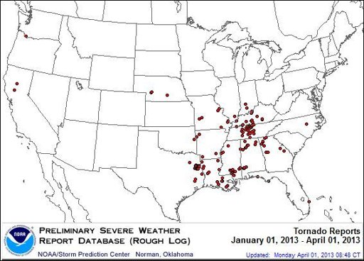
March is typically when tornado season ramps up, with spring's unstable weather giving rise to thunderstorms and twisters. But this year has been relatively quiet so far.

By early April 2012, there had been 290 tornadoes, including 60 tornado-related deaths. But this year, there have only been about 137 reported twisters, resulting in two fatalities, National Weather Service (NWS) records show.

So why so few twisters? The main reason, so far, is that it has been a colder-than-average spring and late winter, at least for much of the central and eastern United States, which is where most of the country's tornadoes occur. This can be blamed largely on a stationary mass of warm air over Greenland and the North Atlantic that has blocked the normal flow of air from west to east and south to north, Greg Carbin, a meteorologist with the NWS' Storm Prediction Center, previously told OurAmazingPlanet.

This flow of air, known as a jet stream, usually brings more warm, moist air from the south as the Northern Hemisphere begins to heat up for the spring.

Instead, winds have predominated from the north, bathing the eastern two-thirds of the United States in Arctic air. This tamps down the formation of tornadoes, which depend on muggy air to fuel their creation and destructive power, Carbin said.

A Tale of Two Marches

 A comparison with last year is somewhat incomplete, since 2012's tornado season got off to a roaring start, thanks to plenty of moist, warm air brought north from the Gulf of Mexico, which helped fuel the month's 154 tornadoes, a cluster of which hit on March 2-3 and were the year's first billion-dollar disaster. March 2012 was the warmest March on record in the U.S. according to the NWS.

The average number of tornadoes for March is 76; this past month, there were only 17 reported, Carbin said. The month was also tied as the second-coldest March since 2000.

http://weather.yahoo.com/where-tornadoes-215130617.html

Monday, March 25, 2013

Snow Reaches DC, Philly; Grazes NYC


A storm responsible for heavy snow from Denver to Kansas City on Saturday and from St. Louis to Indianapolis on Sunday will continue to affect the mid-Atlantic into Monday evening with snow, slush and rain.

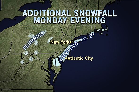
The heaviest snow will focus over part of South Jersey into Monday evening and could briefly swing into central and eastern Long Island for a time Monday night, following rain. These areas have the best chance at picking up a quick couple of inches. The timing of the snow along the mid-Atlantic coast should coincide with when road surfaces are cooling Monday evening.

As the storm heads out to sea later Monday night, precipitation will shut down from west to east from the western suburbs of the I-95 cities to the coast. However, pockets of flurries and intermittent snow will remain behind over the Appalachians and the Ohio Valley.

 From Washington, D.C., to Baltimore, Wilmington, Philadelphia, Trenton and New York City, precipitation falling for part of the day on Monday fought the March sun effect. Even when concealed by clouds, enough energy gets through to warm road surfaces, causing some or all of the snow to melt.

It has to snow very hard in urban areas to overwhelm the sun effect and accumulate on paved and concrete surfaces during the middle of the day. The greatest amount of snow will be on grassy and elevated surfaces from Washington, D.C. to Trenton, N.J. The snow had more success accumulating northwest and southeast of this major urban highway.

http://local.msn.com/WeatherArticle.aspx?cp-documentid=256943846

Midwest, northeast March Snowstorm Breaks Records

A snowstorm that will impact much of the Northeast Monday through Monday night is responsible for many cities record-breaking daily snow totals for the month of March.

The snow total for St. Louis, Mo., on Sunday was 12.4 inches, breaking the city's old record of 12.1 inches set in 1912.

Lincoln, Ill., broke their daily snow total of 4 inches which was set in 1947 with 10.8 inches of snow on Sunday.

As the storm moved through Columbus, Ohio, a record of 2.9 inches, reported at the airport, broke the old record of 1.8 inches set in 1965.

Although record-breaking snow didn't happen in some cities, there were some impressive snow totals in Ohio associated with the snowstorm. Newtown Falls received 3 inches, Marion received 5.2 inches and 4.9 inches was reported in Delaware.

Minimal snow was reported in Columbus, Ohio, as of early Monday morning.

Washington, D.C., also had notable accumulation. The city received its first inch of snow in the city during the month of March since 2011 due to this storm system.

Less than a half of an inch of snow was reported to be still on the ground in D.C. on Monday morning.

http://local.msn.com/WeatherArticle.aspx?cp-documentid=256940922

Powerful storm blankets parts of U.S. Midwest with snow

(Reuters) - There was little sign of spring across a large swath of the U.S. Midwest on Sunday as a powerful storm dumped heavy snow across a widespread area and threatened to bring more.

The storm was part of the same system that blanketed parts of Colorado and northwest Kansas with heavy snowfall on Saturday, said Ariel Cohen, a meteorologist with the National Weather Service. That included accumulations of nearly 19 inches of snow in Boulder County, Colorado, Cohen said.
The storm was moving across the mid-Mississippi Valley region on Sunday and had already left more than 6 inches of snow by mid-afternoon in parts of east-central Missouri, including the St. Louis area, Cohen added.

He said Indianapolis, Columbus, Ohio, and Pittsburg were also expected to be hit with heavy snowfall as the storm tracked east, possibly affecting coastal New Jersey and New England by late Monday and early Tuesday.

Some snow was possible in the Washington, D.C., area late Sunday and into Monday morning but Cohen said temperatures there were a too warm for any substantial accumulation.

http://weather.yahoo.com/powerful-storm-blankets-parts-u-midwest-snow-192125582.html

Spring snowstorm hits central states, pushes east.


PITTSBURGH (AP) — A wide-ranging storm is hitting the East Coast after blanketing the Midwest and burying thoughts of springtime weather under a blanket of heavy wet snow and slush, though less snow was predicted to fall as the storm moves eastward.

Light rain and snow fell in New Jersey on Monday morning after as the storm dropped 2 to 6 inches in Ohio.

Similar accumulations were expected in some areas of Pennsylvania, except for higher elevations like the Laurel Mountains southeast of Pittsburgh, where 6 to 10 inches were forecast. No major problems reported.

In the mid-Atlantic, Heather Sheffield, a meteorologist with the National Weather Service in Sterling, Va., said more than 3 inches of snow had been reported by 8 a.m. Monday at Washington Dulles International Airport, and more than an inch at Reagan National Airport.

 And, the slushy morning commute and widespread school delays as the storm moved eastward were minor compared to the storm's impact on the Midwest, where it was blamed for separate crashes in Illinois, Kansas and Missouri on snow-slicked roads.

Springfield, in central Illinois, got slammed with a record 17 inches of snow, and several central Indiana counties declared snow emergencies after getting hit with up to 8 inches of snow.

The storm was expected to weaken as it moved east. Before it exits off the coast of New Jersey on Monday night, the storm was forecast to leave 2 to 4 inches in that state as well as Delaware, northern Maryland and southern New York.

http://weather.yahoo.com/spring-snowstorm-hits-central-states-pushes-east-085406171.html

Sunday, March 17, 2013

Severe Weather Threat Monday: Nashville, Birmingham

The unseasonable warmth across the South will go out with a bang on Monday--in the form of severe weather across the Tennessee Valley.

Southeastern Kentucky, central and eastern Tennessee, northeastern Mississippi, northern Alabama and northwestern Georgia are expected to become the target of violent thunderstorms on Monday afternoon.

The strongest of these thunderstorms will be capable of unleashing damaging winds, hail and downpours. A few tornadoes may also touch down and cause destruction.

The powerful thunderstorms will then shift to the south and east early on Monday night, rattling southwestern Virginia, western North Carolina, places just to the north and west of Atlanta and central Alabama.

Among the communities in Monday's threat zone include London, Ky., Nashville, Knoxville and Chattanooga, Tenn., Tupelo, Miss., Huntsville and Birmingham, Ala., and Rome, Ga.


Sparking Monday's severe weather will be a cold front, part of the storm that will soon return disruptive snow to parts of the Upper Midwest and Northeast, set to erase April-like warmth encompassing the South this weekend.

http://local.msn.com/WeatherArticle.aspx?cp-documentid=256793892

March 2013's Slow Tornado Pace Could Change Soon


March tornadoes are getting off to a very slow start this year, according to The Weather Channel's severe weather expert Dr. Greg Forbes. But it all could change soon.

An EF-1 tornado hit in Glascock County, Ga. on March 5. Three homes and and a church were damaged. That tornado is the only confirmed tornado anywhere in the U.S. this month, making it the slowest start to tornado season since 2002.

This year's March lull is dramatically different from the weather pattern one year ago. In 2012, a two-day severe weather outbreak March 2 and 3 produced 69 tornadoes, setting a dramatic pace that would end with more than 150 twisters for the month.

But Dr. Forbes reminds us severe weather, particularly heading toward Spring, can pick up rather quickly.

"It only takes one big tornado outbreak to make a huge difference," Dr. Forbes explained.

Those changes could happen by the middle of next week. Dr. Forbes says some weather prediction models are picking up on rising chances for severe weather around March 20.

 http://www.weather.com/news/tornado-central/march-tornado-slow-pace-20130313

Friday, March 8, 2013

'Snowquester' doesn't pan out in DC; situation nastier in Virginia

People walk as snow falls at the U.S. Capitol in Washington on Wednesday, March 6. A winter storm that set snowfall records in Chicago arrived in the capital region early Wednesday, shutting down federal offices and schools. It's been dubbed "snowquester," a play on the recent forced spending cuts in government.

But where 5 to 10 inches of wet snow was supposed to fall on DuPont Circle, not even slush was accumulating Wednesday afternoon, said organizer Michael Lipin.

While the storm was dumping plenty of snow in other places, Washington was getting just fractions of an inch, said CNN meteorologist Sean Morris.

In fact, the National Weather Service dropped its winter storm warning for the Washington area Wednesday afternoon.

In nearby Virginia, however, things were quite different.

Transportation officials reported particularly nasty conditions on many secondary and some primary routes in 15 central and northern counties, with deep snow or ice covering the pavement. State and many county offices closed early.

The storm is the same one that earlier dumped about a foot of snow in parts of Illinois, Minnesota and North Dakota, paving a white swath across the Upper Midwest.

Chicago's O'Hare International Airport had 6 inches of snow Tuesday, beating a 1999 record for the date by 2.2 inches. It was the first snowfall of 6 inches or more in the Windy City since February 2011, the weather service said.

Plows removed snow from roads and trucks spread salt and sand, but drivers still slipped off of roadways, leaving snow-covered cars to be retrieved by tow trucks.

Tuesday's snow put a drag on air traffic in the Midwest, leading to delays and cancellations, but planes continued to fly in Columbus, Ohio, and Minneapolis, Minnesota, after plows removed the snow from runways.

http://www.cnn.com/2013/03/06/us/winter-weather/index.html

Late-winter storm hampers New England

 Ocean waves crash over a seawall and into houses along the coast in Scituate, Mass., Thursday, March 7, 2013. A winter storm brought strong winds to coastal areas in the state. (AP Photo/Steven Senne)

A slow-moving storm centered far out in the Atlantic Ocean dropped up to a foot of snow in New England, caused coastal flooding in Massachusetts and slowed the morning commute in the region to a slushy crawl.

 In Massachusetts, flooding at the morning high tide closed some coastal roads north and south of Boston. On Plum Island, north of Boston, an unoccupied home fell into the ocean, apparently a victim of high tide, according to the Newburyport Daily News.

 Snow and accidents were making the morning commute in Connecticut difficult for a second-straight day on Friday.

Some parts of the state had a foot or more by midmorning, with more expected before the storm peters out early in the afternoon. A winter storm warning remains in effect until 1 p.m.

In Scituate, Mass., a shoreline town about 20 miles south of Boston, police Chief Brian Stewart breathed a sigh of relief Friday morning after high tide.

Some less severe beach erosion was forecast along the southern Maine coast, and up to six inches of snow in southern Maine and New Hampshire.

http://weather.yahoo.com/winter-storm-hampers-england-142830054.html

Saturday, March 2, 2013

St. Louis to Cincinnati: Travel-Disrupting Snow


The same storm that will threaten the mid-Atlantic during the middle of next week will first cross the Plains and Ohio Valley with the potential for moderate to heavy snow.

The storm will start to spread snow across the northern Plains on Sunday night into Monday. Accumulations should generally be light across the Dakotas, southern Minnesota and Iowa.

However, travel could still become slick and dangerous along portions of I-29, I-80, I-90 and I-94.

Once the storm reaches the Ohio Valley next Monday night into Tuesday, it will pick up steam and gather moisture from the Gulf of Mexico. The intensity of snow is expected to increase as a result.

Cities in the path of moderate to heavy snow as the storm ramps up include St. Louis, Louisville and Cincinnati. Flight delays and cancellations due to snow are possible in this zone.

Some light snow may reach as far north as Minneapolis and Chicago on the northern edge of the storm.
 
http://www.foxnews.com/weather/2013/03/01/st-louis-to-cincinnati-travel-disrupting-snow-possible/


Freezing Temperatures for Florida, Deep South


The Deep South is immersed in a cold flow of air, and the chill will persist through Monday morning. Not until Tuesday will a milder southwesterly wind allow temperatures to rebound to normal.

Though it's quite chilly with sub-freezing temperatures due across the interior of the northern third of Florida Sunday night, it's not nearly as cold as it could be this time of year. Here are some of record lows for the first week of March: Tallahassee 20, Jacksonville 23, Gainesville 22, Tampa 29, Orlando 25 and Fort Myers 33. None of these records will be touched Sunday night.

The rest of the Southeast will have low temperatures in the 20s Sunday night but that's not terribly unusual for this time of year.

The daylight hours won't be much kinder to the locals. Throughout the Southeast highs in the 40s and 50s will be common place Sunday and one will have to be south of Tampa to have highs in the 60s. But even 60s, which are quite pleasant in the mid-Atlantic in early March, are well below normal in the Sunshine State.

Turning the page to next week Tuesday will be noticeably warmer especially from Georgia southward. To the north however, it will remain on the cool side early in the week and another shot of cold will hit the the Carolina region Wednesday. That next surge of cold air will be accompanied by snow late Tuesday night and Wednesday morning. Eastern Tennessee and western North Carolina could get a few inches then and up to a foot of snow will fall on the Smokey Mountains.

http://local.msn.com/WeatherArticle.aspx?cp-documentid=256545669

Tuesday, February 19, 2013

Winter storm to hit US from Calif. to Midwest

A winter storm moving in from the Pacific Ocean was expected to bring a foot or more of snow and 75 mph wind gusts to mountainous areas of California on Tuesday, before aiming for the Midwest and laying down a wintry blanket as it goes, the National Weather Service said.

 Even coastal Californians would feel the storm's wrath in the form of high winds and heavy rains, forecasters said.

Meteorologists said the storm originated in the Gulf of Alaska and was taking a southerly course that would hammer California before the system turns inland and strikes as far northeast as Chicago and the Midwest.

Mountainous parts of Los Angeles, San Diego and Ventura counties in California were under winter storm warnings, and snow could present a danger on mountain highways, including Interstate 15 the weather service reported.

Those on the Southern California coast were expected to see see wind-whipped waves. High-surf advisories, predicting waves up to 10 feet, have been issued from Ventura County south through Los Angeles, Orange and San Diego counties.

Up to two inches of rain could fall in some areas as the storm moves through, and high winds and snow are likely to also cause problems inland, in heavily populated Riverside and San Bernardino counties, both of which are under winter storm and high-wind warnings.

Weather Channel meteorologist Nick Wiltgen said that as the storm moved eastward, cold air from Canada and moist air from the western Gulf of Mexico would mix to bring snowfalls of up to an inch an hour for several hours, setting the stage for a "major winter storm" over the Plains that could produce double-digit snowfalls along the Interstate 80 corridor. Just to the south, an icy mix could make travel treacherous.

Chicago is expected to get heavy snowfall later in the week (Thursday night into Friday).

http://usnews.nbcnews.com/_news/2013/02/19/17014410-winter-storm-to-hit-us-from-calif-to-midwest?lite

Muliple chances of storms in South

The next significant threat of severe thunderstorms begins late Wednesday in the southern Plains.  Large hail and some high wind gusts are the primary threats overnight Wednesday night in Texas and extreme southern Oklahoma, potentially including Dallas, Austin and San Antonio.

The severe threat then sweeps into the Lower Mississippi Valley Thursday, including parts of east Texas, Louisiana and Mississippi, in association with Winter Storm Q.

Damaging straight-line winds, hail, and possibly a few tornadoes are possible in these areas, including Houston, Baton Rouge, and New Orleans.

The height of the storms will begin late on Wednesday and continue to travel into Thursday. Looking at the map below, it appears that the bulk of the thunderstorms will occur on Thursday during the day. Wednesday night temperatures may drop and clouds will begin to form.

The weather map below for Thursday shows a slight chance of tornadoes (dark red color) developing near Houston, New Orleans and Jackson.

 http://www.weather.com/news/weather-severe/severe-weather-tracker

Friday, February 15, 2013

Severe Weather slams India and Pakistan

Severe weather has affected northern parts of India and Pakistan.

In Pakistan days of torrential rain have triggered flash floods, which have led to the death of at least 29 people. Most of the causalities occurred when people’s homes collapsed on them.

The worst hit region has been the northwest, on the border with Afghanistan, but elsewhere the rain has also been exceptionally heavy.

Islamabad reported 191mm of rain in three days. This is nearly three times the amount you’d expect in the entire month of February.

The same weather system also brought heavy snowfall to parts of northern India.

Some districts over the higher reaches of Himachal Pradesh have seen as much as 90cm of snow recently.

Snow here often provides a welcome boost to tourism and the hospitality sector, but this has been disruptive.
Fortunately the weather system has now cleared and no more significant rain or snow is expected in the coming days.


http://www.aljazeera.com/weather/2013/02/20132791824919718.html