Showing posts with label Jada Fleming. Show all posts

Tuesday, October 21, 2014

Gulf of Mexico Low: Heavy Rain Threat for South Florida, Cuba, and Mexico

Gulf of Mexico Low: Heavy Rain Threat for South Florida, Cuba, and Mexico
 
This system is expected to slowly move east to east-northeast and be near the Yucatan Peninsula midweek. It may then interact and possibly merge with a frontal system towards the end of the week.
Later in the week, the path of the low pressure could bring it closer to Florida, enhancing rainfall through at least Friday and possibly into the weekend. By that time, it's unlikely to be a tropical cyclone, given the likelihood of merging with the frontal system

Part of this low has come from Trudy, which made landfall in southwestern Mexico on Saturday, bringing heavy rain and deadly mudslides. It is possible that if it does develop it could retain the name Trudy or it could become Tropical Depression Nine and then possibly strengthen into Tropical Storm Hanna.
Conditions are generally favorable for development, as water temperatures are warm and wind shear is expected to be low in the region. However, just to the north of this system, over the next few days, there will be strong upper-level winds and very dry air, which are not conducive to tropical development.

Regardless of whether this low pressure develops into a tropical depression or a tropical storm, locally heavy rain remains possible in south Florida, especially Thursday and Friday. Even Tuesday and Wednesday rain chances will be higher than usual for this time of year in southernmost parts of Florida due to the tropical moisture that will be over the region.
Heavy rain was already reported on Monday night with the Florida Keys Marathon Airport reporting over four inches of rain. Parts of West Palm Beach picked up over 7 inches of rain Tuesday.

http://www.wunderground.com/news/heavy-rain-south-florida-gulf-mexico-tropical-threat-20141020


Nor'easter Expected To Bring Heavy Rain, Strong Winds, Beach Erosion To The Northeast, Mid-Atlantic

Nor'easter Expected To Bring Heavy Rain, Strong Winds, Beach Erosion To The Northeast, Mid-Atlantic
 
 
An upper-atmospheric area of low pressure sliding southeast from the Great Lakes has spawned an area of low pressure. This low was over the Delmarva Peninsula late Tuesday evening and will quickly slide off the Atlantic coast, then remain off the New England coast through at least Thursday. The low will also intensify as it meanders off the Eastern Seaboard.
This low will combine with a strong surface high pressure system in eastern Canada to create a tight pressure gradient which will bring strong easterly to northeasterly winds into parts of the Northeast. This is an onshore wind for parts of New England, raising concerns for coastal flooding and beach erosion due to the prolonged duration and long fetch of these winds, particularly from the North Shore region of Massachusetts into Downeast Maine.
The subtropical jet stream will also move north which will bring tropical moisture northward, enhancing the rainfall across the region.
Anywhere from the northern Mid-Atlantic to New England will likely be affected by heavy rain and strong winds. The exact track of the low will determine the timing and location of the heaviest rain and strongest winds.


http://www.wunderground.com/news/noreaster-heavy-rain-strong-winds-beach-erosion-northeast-mid-atlantic-20141018


Gonzalo's Remnants Hit the United Kingdom: 2 Killed, Travel Disrupted

Gonzalo's Remnants Hit the United Kingdom: 2 Killed, Travel Disrupted
 
The remnants of Hurricane Gonzalo swept across the United Kingdom Tuesday, bringing high winds that disrupted travel and downed trees, killing at least two people.
Wind gusts reached 80 mph, the BBC reports, and the U.K. Met Office to issue a "yellow warning" -- signaling residents to be aware of potential impacts -- for windy conditions.
And that's exactly what has played out. There are multiple reports of trees downed by high winds across the region, and in central London, gusty winds caused a tree from foliage-rich Hyde Park to land on a woman walking across the street from Hyde Park Barracks. The woman was pronounced dead on the scene, according to the London Ambulance Service.
The second death happened midday in Essex. The UK Telegraph reports high winds collapsed a car jack, sending the van it was holding onto the man underneath it.In addition to gusty winds, the U.K. Environment Office issued flood warnings for coastal areas in the Anglian region of the U.K., warning of high tides, amplified by tidal surge and strong winds,  that could flood residences. The office also issued more than a dozen flood alerts for northern, southern and eastern portions of the U.K., hinting at the possibility for widespread flooding in the region.


http://www.wunderground.com/news/gonzalo-united-kingdom-travel-20141021


Tuesday, October 14, 2014

Severe weather: 32 million in U.S. at risk, air travel could suffer

A car is damaged after severe weather passed through Little River County, Arkansas, on Monday.


Severe weather: 32 million in U.S. at risk, air travel could suffer


CNN) -- Storms battering the southern United States put 32 million people from West Virginia to Florida at risk of facing severe weather Tuesday, CNN Meteorologist Indra Petersons reported.
Air traffic could be affected as Atlanta, home to the world's busiest airport, is included in the threat, Petersons said.
By 2 p.m. ET, Hartsfield-Jackson Atlanta International Airport had more than 200 delays Tuesday, according to flightaware.com.
The storms are already blamed for two deaths, the first October tornado fatalities in the United States since 2009, CNN Meteorologist Pedram Javaheri reported. Both took place Monday -- one in Alabama and another in Arkansas.


Severe Storms Hit North Texas; Lightning Sets Oil Well on Fire; Thousands Without Power

Severe Storms Hit North Texas; Lightning Sets Oil Well on Fire; Thousands Without Power
 
Heavy rains and powerful winds hit North Texas early Monday morning, toppling power lines, leaving thousands without power, and causing a home and oil well to catch fire.
In Longview, about two hours east of Dallas, a lightning strike caused a large oil well fire, leading police to evacuate the nearby area, according to KETK NBC.
KLTV-7 reports that the oil well fire was brought under control at 8:30 a.m. Monday morning and the 20 households and 13 businesses evacuated were allowed to return. No injuries have been reported from the fire.
Lightning struck a home in Denton County around 2 a.m. Monday and caused a fire that left the home significantly damaged, according to NBC DFW. The couple living in the home made it out safely.
The Dallas Morning News reports that over 20,000 homes and businesses are without power across the Dallas-Fort Worth metroplex. Dallas saw the bulk of the outages with 8,000 powerless.
Several roads were closed across the metroplex after high winds blew down power lines. NBC DFW reports that authorities closed down a section of a major highway after a two-car wreck blamed on the storms.
There have been no reports of injuries in the Dallas-Forth Worth metroplex, but the same outbreak of severe weather killed at least one person in southwestern Arkansas.
Severe weather is expected to continue moving throughout the Deep South, possibly generating damaging winds, lightning and hail.

Hurricane Gonzalo Damages Homes, Injures 12 in Antigua; 5 Missing in Martinique

Hurricane Gonzalo Damages Homes, Injures 12 in Antigua; 5 Missing in Martinique
 
Hurricane Gonzalo was moving through the Caribbean Tuesday morning as a Category 2 storm, disrupting travel across the region, causing structural damage to homes in Antigua and causing the disappearance of five people.
Those five people were said to be aboard boats off the coast of Martinique that either ran aground or were sent drifting into the ocean due to Gonzalo. Search crews from Martinique, Guadeloupe and St. Maarten were scouring the coasts and ocean looking for the missing people, but it wasn't immediately clear exactly where they went missing.
Hundreds of power outages were reported on the north coast of Puerto Rico, but the U.S. territory escaped major damage because Gonzalo's eyewall remained miles off the coast as it passed by.
Antigua and the Leeward Islands took the brunt of the storm on Monday, when Gonzalo was still a Tropical Storm, downing trees, ripping roofs off of homes and causing at least 12 minor injuries on the island nation of around 80,000 people.
Winds, which gusted up to 88 mph, damaged a luxury hotel on the west coast of Antigua, tourists told The Weather Channel.


http://www.wunderground.com/news/hurricane-gonzalo-travel-puerto-rico-anguilla-antigua-20141014


Wednesday, October 8, 2014

The latest on severe weather around Oklahoma City

The latest on severe weather around Oklahoma City
 
(CNN) -- As they dug out from deadly twisters that ravaged the Oklahoma City metropolitan area -- with the suburb of Moore being hardest hit -- people there suffered through yet another powerful storm Friday.
The National Weather Service reported numerous tornadoes around the area. The agency also noted there was a "confirmed and extremely dangerous tornado" around St. Louis, Missouri.The two people reported dead at Integris Canadian Valley Hospital in Yukon are a mother and a child, Integris Health's Brooke Cayot said. She said that hospital received 14 patients, three of them critical.
-- More than 170,000 customers are without power Friday night throughout the Midwest -- including in Oklahoma and Missouri -- after severe weather rocked the region.-- Some 50,000 customers in the Oklahoma City metropolitan area were without power at about 8 p.m. Friday (9 p.m. ET), Oklahoma Gas and Electric reported.


China's Yunnan Province Rocked by Strong Earthquake; At Least 1 Dead

China's Yunnan Province Rocked by Strong Earthquake; At Least 1 Dead
 
A strong earthquake rattled southwest China's temblor-prone Yunnan province Tuesday. Preliminary reports indicate at least one person was killed and a number of buildings were damaged.
The U.S. Geological Survey said the earthquake measured magnitude 6.0 and was centered 18 kilometers (11 miles) from Weiyuan city at a depth of 10.9 kilometers (6.7 miles). Its shallow focus was likely to cause greater damage, but there were no immediate reports of serious destruction.
China's national earthquake monitoring agency gave the quake's magnitude as 6.6 and said it struck just 5 kilometers (3.1 miles) below the surface. It said the quake was followed by eight aftershocks, the strongest of which registered at magnitude 4.2.
The earthquake occurred at 9:49 p.m. local time (9:49 a.m. EDT in the U.S.), when most people would have been at home.The remote mountainous region near the border with Myanmar is prone to earthquakes. A 6.1-magnitude quake in northern Yunnan in August killed at least 615 people and left more than 100 others missing. In 1970, a magnitude-7.7 earthquake in Yunnan killed at least 15,000 people


http://www.weather.com/news/china-earthquake-yunnan-20141007


Snow in September? Severe storm brings hail, snow to Colorado

Snow in September? Severe storm brings hail, snow to Colorado


DENVER -- Some people in Colorado are cleaning up after hail piled up like snow in some areas.
In western Colorado, the National Weather Service says several people reported golf-ball size hail near Pagosa Springs on Monday.
The system that brought the unusual early fall weather to Colorado is headed for the Midwest, where officials have issued warnings about severe thunderstorms across the Great Plains.
Quarter-sized hail piled up like snow in Greenwood Village while the unsettled weather led to a tornado watch for 14 counties.
Monday's raging storm damaged more than 500 cars and shattered windows at the Hyundai dealership in Arapahoe.


colorado-weather-snow.jpg


http://www.cbsnews.com/news/snow-in-september-severe-storm-brings-hail-snow-to-colorado/


Tuesday, September 30, 2014

Albuquerque Festival Tent Flattened in Surprise Microburst; Wild Hailstorms Strike Denver

Albuquerque Festival Tent Flattened in Surprise Microburst; Wild Hailstorms Strike Denver
The Weather Channel has confirmed that no severe thunderstorm or tornado warnings had been issued by the National Weather Service in Albuquerque prior to the burst of wind, which hit the festival site at approximately 2:10 p.m. The NWS office issued a "significant weather advisory" for 55-mph wind gusts and half-inch-diameter hail at 2:14 p.m. for a "strong thunderstorm 7 miles southeast of Albuquerque" affecting eastern Bernalillo and northern Valencia counties.A Weather Underground personal weather station in Hugo, Colorado, recorded a 76-mph wind gust at 5:49 p.m. MDT. Another weather observer in rural Cheyenne County, Colorado, reported an 84-mph gust to the National Weather Service at 6:10 p.m. MDT.


Strongest Storm on Earth In Route to Hong Kong

Strongest Storm on Earth In Route to Hong Kong


Super-Typhoon Usagi became the strongest storm on Earth on Thursday. Though it’s weakened since then, the storm is still churning toward Hong Kong and could create major disruptions with a likely landfall as early as Sunday.
On Thursday, Usagi measured sustained wind speeds of 160 mph. Those winds made it the strongest storm on Earth this year, besting Utor, which recorded wind speeds of 150 mph prior to making landfall in the Philippines in mid-August according to the Capital Weather Gang. NASA created a 3D satellite image of Usagi at its peak, showing an extremely well-developed eyewall.
 Measurements by the Joint Typhoon Warning Center on Friday morning showed that Usagi had sustained winds of 150 mph with gusts up to 184 mph. That’s still enough to classify it as a supertyphoon or make it the equivalent of a Category 4 hurricane. The storm is also kicking up waves as high as 45 feet.
The storm is expected to deliver a sharp blow to Taiwan on Friday and Saturday before likely heading toward Hong Kong. Taiwan’s Central Weather Bureau has issued an “extremely torrential rain advisory” for the southeastern part of island. The storm could potentially drop 20-30 inches of rain on Taiwan over the next two days. That’s prompted the Defense Ministry to deploy more than 1,600 soldiers to areas most prone to landslides and flooding according to AFP.
 
http://www.climatecentral.org/blogs/strongest-storm-on-earth-en-route-to-hong-kong-16508


Monster Cyclone Phailin Poses Deadly Threat to India

Monster Cyclone Phailin Poses Deadly Threat to India


One of the strongest tropical cyclones to form in the Bay of Bengal since 1980 is heading for the northeast Indian state of Odisha, packing winds of close to 160 mph and a storm surge of at least 10 feet, but possibly much higher. The storm, named Phailin — a Thai word for “sapphire” — has intensified after weakening for a time on Thursday. By some measures, it may already have become the strongest storm on record in the Indian Ocean. It is expected to make landfall in Odisha or the far northeastern corner of the Andrha Pradesh State on Saturday afternoon or early evening.
Sea level rise due to climate change will only increase the risk of low-lying areas in Bangladesh and India to cyclone-related storm surge events. As weather.com reported, one small island that was involved in a dispute between India and Bangladesh disappeared entirely in 2010 due to rising water. 


Tuesday, September 23, 2014

Tropical Storm Fung-wong: At Least 13 Dead, Thousands Evacuated As Storm Lashes Philippines, Taiwan

Tropical Storm Fung-wong: At Least 13 Dead, Thousands Evacuated As Storm Lashes Philippines, Taiwan
 
Thirteen people are now dead and 18 injured in two countries as tens of thousands have been forced from their homes due to Tropical Storm Fung-wong, which lashed the Philippines and then Taiwan with extremely heavy rainfall.
The Philippine government's National Disaster Risk Reduction and Management Council says 425 houses have been destroyed and another 1,710 damaged due to the storm, which was called "Mario" in the Philippines. Laoag reported a peak wind gust of 60 mph during the storm's passage. Rain continued Sunday even after the tropical storm itself had moved on to Taiwan, and the Laoag observation site had received 457.1 millimeters (18.00 inches) of rain in the 78-hour period ending at 8 p.m. local time (8 a.m. EDT) Sunday.

View image on Twitter
 

El Paso, Texas Flash Flooding Kills One; Cars Washed Away, Water Rescues

El Paso, Texas Flash Flooding Kills One; Cars Washed Away, Water Rescues
 
 
Flash flood warnings were reissued Monday afternoon as a new round of heavy thunderstorms developed over the El Paso, Texas, metropolitan area, where flash floods earlier in the day turned deadly. By Monday night, numerous roads were flooded in the Las Cruces area.
Earlier Monday, a cluster of heavy rain parked over the north side of El Paso and triggered deadly flash flooding. 64-year-old Consance Manzanares drowned Monday after her car was trapped in a canal by flood waters, KVIA reports. 
A National Weather Service employee measured 5.37 inches of rain in just over four hours over a part of the northeast El Paso metro northwest of Biggs Army Airfield. Incredibly, just about five miles away, El Paso International Airport only picked up around one-quarter inch of rain Monday morning.
This is roughly equal to the city's combined average rainfall from July through September (5.07 inches).

http://www.weather.com/news/weather-severe/el-paso-texas-flooding-20140922
View image on Twitter

Northeast India Flooding, Mudslides Kill at Least 28

Northeast India Flooding, Mudslides Kill at Least 28
  
 
Two days of heavy rainfall have triggered flooding and mudslides in India's remote northeast, killing at least 28 people.
Fourteen of those people died in northern Meghalaya state, while another 14 people died in neighboring Assam state, where the capital, Gauhati, and several districts experienced severe flooding.
Ninety villages were completely flooded in Assam's Goalpara district, forcing the evacuation of 150,000 people, according to district official Pritam Saikia. Once the local shelters were totally filled with evacuees, residents were left with no choice but to camp out on a state highway.
The rain halted for several hours Tuesday, but more rain was forecast for the next 36 hours.
The area is prone to flooding during the June-to-September monsoon season. In June, at least 11 people were killed in heavy flooding in Gauhati city.


http://www.wunderground.com/news/india-flooding-mudslides-20140923


Tuesday, September 16, 2014

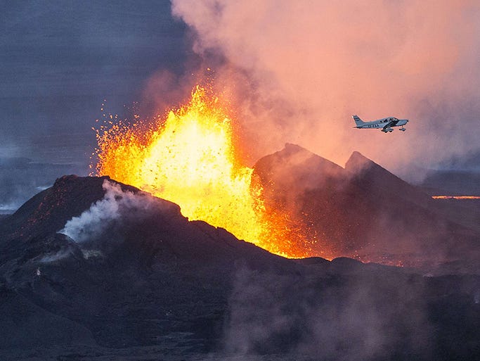
Breathtaking Photos of Iceland's Bardarbunga Volcano

Breathtaking Photos of Iceland's Bardarbunga Volcano

  
Volcanic activity near Iceland's Bardarbunga volcano is creating some spectacular scenes on the island nation. Earthquakes and other seismic activity first started in the area in mid-August, prompting fears of an explosive glacial eruption, but so far the only human impacts appear to be health related, with fumes from the volcano causing sore throats, headaches and other minor irritations.
Instead volcanologists and casual sightseers alike have been treated to fountains of brilliant-colored lava spewing out of large fissures at the surface of the Holuhraun lava field. According to Vox, the fissures are ejecting lava up to 165 feet into the air, part of a lava flow that's more than 10 miles long.
Lava eruptions started on August 31, and according to Wired, geologists at Iceland's Meteorological service believe the scenes like the ones seen above could play out for more than a year. Even though these type of eruptions are largely harmless to humans -- save for the aforementioned health impacts -- geologists aren't ruling out the possibility for a much more devastating eruption at Bardarbunga.

An aircraft flies over the erupting Bardarbunga volcano on Sept. 14 in southeast Iceland. The volcano has been rocked by hundreds of tremors since mid-August, prompting fears that it could explode.


http://www.wunderground.com/news/icelands-bardarbunga-volcano-photos-20140916

Pakistan, India Flood Leaves Health Risks in Its Wake


Pakistan, India Flood Leaves Health Risks in Its Wake

    Recent flooding in the Himalayan region of Kashmir, divided between India and Pakistan, has left an "unprecedented catastrophe" in the region, local officials said Tuesday, as fears over health problems brought on by the onslaught of water take center stage.
With hundreds of thousands of individuals displaced, and at least 528 dead, "the chance of cholera, jaundice and leptospirosis spreading are high," said Dr. Swati Jha with the aid group Americares. "The most essential need right now is that of clean water."
Countless bloated livestock carcasses were floating across the waterlogged Kashmir region of India, The Associated Press reported Tuesday. Many residents, warned to avoid the floodwaters, were rationing water bottles brought every few days by aid workers, as people accused the government of having been slow to respond to the floods that hit the Himalayan region.
Most hospitals have been inundated, their diagnostic equipment, CT scanners, operation theaters and ventilators destroyed.


http://www.wunderground.com/news/pakistan-india-flood-leaves-health-risks-its-wake-20140916

Odile Dumping Heavy Rains on Southwest U.S.; Edouard Becomes a Major Hurricane

Odile Dumping Heavy Rains on Southwest U.S.; Edouard Becomes a Major Hurricane    Residents of Mexico's Baja Peninsula are picking up the pieces after devastating Hurricane Odile smashed ashore at Cabo San Lucas near 12:45 am EDT Monday as a Category 3 storm with 125 mph winds. Odile was the strongest hurricane on record to hit the Baja Peninsula, tied with Hurricane Olivia of 1967. Odile's powerful winds caused heavy damage on the southern tip of Baja, where the tourist meccas of Cabo San Lucas and San Jose del Cabo lie. The airports in both cities are closed, with the San Jose del Cabo airport (7th busiest in Mexico) closed until September 22, and the Cabo San Lucas airport may be closed until October. Fortunately, no deaths are being attributed to the hurricane--a tribute to the excellence of Mexico's civil defense system.
     

http://www.wunderground.com/blog/JeffMasters/comment.html?entrynum=2800

Tuesday, September 9, 2014

El Nino may bring good weather news -- depending on where you are

A map shows sea surface temperatures in the equatorial Pacific Ocean Wednesday.

The National Oceanic and Atmospheric Administration said Thursday that there's about a 50% chance of a weather phenomenon called El Nino developing this summer or fall. That's not a guarantee, but conditions are favorable enough in the next six months to warrant an "El Nino Watch."
An El Nino event occurs about once every three to seven years, said Kevin Trenberth, senior scientist at the National Center for Atmospheric Research. It involves the warming of the central and eastern Pacific Ocean, and results in major changes in the jet stream where storms track.
As the ocean builds up heat in the western Pacific Ocean, some of the heat goes into the atmosphere through evaporation. The moistened atmosphere invigorates storms, Trenberth said, changing where hurricanes and typhoons occur.
 

Weather slows wildfire at Yosemite National Park that dozens fled

California Wildfires 9714.
 
YOSEMITE NATIONAL PARK, Calif. — Cooler weather on Monday slowed the spread of a wildfire that forced the helicopter evacuation of dozens of people from the famous Half Dome rock in Yosemite National Park.
"We were pleasantly surprised with high humidity and scattered showers throughout the morning," said Kari Cobb, a park ranger. "So anytime you have weather like that it's going to help suppress fire activity."
The fire, which had burned about 4 square miles of timberland, wasn't threatening any buildings. The park remained open, but some campsites were closed.
About 120 firefighters and 11 aircraft fought the blaze, which may have erupted from embers of a fire sparked by lightning several weeks ago, officials said.
Firefighters had monitored and controlled that fire before winds and temperatures increased on Sunday.
On Sunday, 100 people were evacuated from Little Yosemite Valley, and 80 to 85 were removed by helicopter from the top of 5,000-foot Half Dome.


http://www.masslive.com/news/index.ssf/2014/09/weather_slows_wildfire_at_yose.html