Showing posts with label Maria Valenzuela. Show all posts

Monday, December 10, 2018

Climate change is not only influencing extreme weather events, it's causing them

https://www.cnn.com/2018/12/10/world/climate-change-extreme-events-wxc/index.html


(CNN)Extreme weather events that spanned the globe in 2017 have been directly linked to -- and in some cases were even caused by -- continued warming of the planet via human influence through greenhouse gas emissions, according to a new report.

For the second year in a row, the annual report from the American Meteorological Society found weather extremes that could not have happened without human-caused warming of the climate. Advances in scientific modeling and additional climbs in temperatures are making the connection between global warming and extreme weather much more concrete.
"Global temperature, the backdrop in which extremes are unfolding, continues to rise. ... Nature is thereby increasingly rolling back its curtain of sensitivity to rising greenhouse gases," Martin Hoerling, a research scientist at the National Oceanic and Atmospheric Administration and one of the authors of Monday's report, wrote in an email.
"This alone is making it easier to scientifically identify the fingerprint of human influence, not to mention improved modeling tools," Hoerling said.
Scientists found that record warm waters in the Tasman Sea in 2017 and 2018 "were virtually impossible without global warming," and they concluded that a crippling drought in East Africa that has led to food shortages for millions of people would not have occurred naturally before the Industrial Revolution, when humans began to interfere with the climate system.

People walk through the flooded streets of Houston on August 27, 2017, after Hurricane Harvey dumped record rains.

Potential tropical cyclone may impact India during mid-December

https://www.accuweather.com/en/weather-news/potential-tropical-cyclone-may-impact-india-during-mid-december/70006841

An area of disturbed weather in the Bay of Bengal may develop into a tropical cyclone later this week and could impact southern India this weekend.

Several days of largely dry weather across southern India into Friday will allow residents of southern India to prepare for potential impacts and evacuations from the storm.

The low pressure system in the Bay of Bengal may strengthen into a tropical depression or cyclonic storm by mid to late week. As it nears the coast of southeast India, regardless of strength, it will likely bring areas of rain and thunderstorms with the risk for flooding and mudslides.

Should it organize into cyclonic storm, the name Phethai would be given to the tropical system.

In this scenario, an area of intense wind and rain would occur near where the storm makes landfall and may spread inland as the storm moves northwestward and weakens.

Based on the current forecast, areas from northern Tamil Nadu into southern Andhra Pradesh are most at risk for impacts from a land-falling tropical cyclone this weekend.

While wind damage will likely be confined to areas close to the coast, downpours may spread far inland bringing the risk for localized flooding to much of Andhra Pradesh and Telangana on Saturday and Sunday.

A few downpours may also reach Orissa and Chhattisgarh, bringing brief travel disruption.

Another concern is that increasing wind around the system is expected to churn up seas across the southern Bay of Bengal. Fisherman in southeast India will have to use extra caution later this week and into the weekend as seas become dangerously rough.

Bathers will also be a risk due to increased surf and rip currents along the coast of Tamil Nadu and Andhra Pradesh.

India 12/10

At least two dead, thousands without power after historic snowstorm in North Carolina

North Carolina was blanketed with too much snow too soon: more than a foot in several areas — and winter had barely just arrived.

Years' worth of snowfall swept through parts of the state in a little more than a day, causing hundreds of crashes, thousands of power outages and at least two confirmed deaths, officials said Monday. Double-digit snowfall totals dropped in many cities and towns over the weekend, far higher than what the state normally sees this time of year.

In one county, five families were stranded while 20 inches of snow buried the area.

By Monday, much of the snow has dissipated, but the state — which is still recovering from the damage wrought by Hurricane Florence in the summer — is not out of the woods yet. A deadly mix of ice and rain will keep roads treacherous, and many could turn into ice rinks overnight, Gov. Roy Cooper said at a news conference.

“Even the parts of our state that didn’t see a flake may feel effects from the storm today,” he said. Coastal communities are under flood warnings, and water may wash over parts of Highway 12, which connects the Outer Banks’s barrier islands.

Cooper issued a state of emergency Friday, and the deluge began Saturday.

Just after 4 p.m. Saturday, a tree fell on a moving vehicle in the Charlotte suburb of Matthews. The vehicle crashed into a nearby church. The driver died, while the passenger suffered minor injuries, police said.

In Haywood County in western North Carolina, a woman in hospice care died in her home, Cooper said. No other details were immediately available.

In the eastern city of Kinston, a truck drifted off the road and into a river. Divers have recovered the truck’s cab, but the driver has not been found, officials said.


https://www.washingtonpost.com/weather/2018/12/10/least-two-dead-thousands-without-power-after-historic-snowstorm-north-carolina/?noredirect=on&utm_term=.f2dd2f350516

After Dumping Snow on the Rockies, The Next Eastern Storm Will Likely Be More Wet Than Wintry

https://weather.com/forecast/regional/news/2018-12-10-next-eastern-storm-more-wet-than-wintry

At a Glance

  • A low-pressure system will bring mainly rain to the central and eastern U.S. late this week into the weekend.
  • The rain could be heavy in some areas.
  • Strong to severe thunderstorms are possible in parts of the South.
  • With limited cold air, any wintry weather should be confined to the nation's northern tier.


A new storm system will sweep from the Northwest to the Rockies into midweek before emerging over the central and eastern United States, where it will likely produce more rain than snow or ice late this week into the weekend.

Rain and mountain snow, heavy at times, are expected in the Northwest Tuesday, with snow then spreading into the Rockies by Wednesday.


The system will emerge over the Plains and Midwest Thursday before slowly moving toward the East Coast Friday into the weekend.

Energy from a disturbance farther south may also track into the central U.S., likely resulting in a strengthening area of low pressure. Moisture from the Gulf of Mexico will surge northward, increasing the amount of precipitation that may fall with this system.


Major storm bringing severe weather to South, whiteout conditions to Northern Plains

https://abcnews.go.com/US/major-storm-bringing-severe-weather-south-whiteout-conditions/story?id=59540477

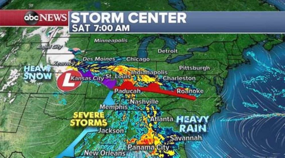
A major storm developing in the central U.S. is bringing ongoing severe weather across the south, a flash flood threat to parts of the Gulf Coast and a major winter storm in the Northern Plains and upper Midwest.

There was one reported tornado in eastern Oklahoma overnight as several tornado warnings were issued in the eastern parts of the state. Additionally, there were nearly 60 reports of strong winds from northern Texas to southern Missouri. Numerous tornado warnings were issued during the overnight hours in southern Missouri, where winds reached 83 mph.

The U.S. averages 24 tornadoes in December with most developing in the southern U.S.

A clear circulation was evident on radar and satellite imagery across Kansas on Saturday morning. This developing major storm will slowly move east during the day.

A tornado watch is in effect for parts of Missouri and Arkansas through the early Saturday morning hours as a line of strong storms moves through the region. A couple of tornadoes will be possible through the early morning hours in the watch area. The risk will diminish by mid-Saturday morning in this region.

Heavy rain has spread from eastern Kansas to Florida and snow is beginning to develop across parts of Nebraska.

PHOTO: Heavy snow will fall in the Plains while severe storms and heavy rain move into the South on Saturday.

If you’re cold, they’re cold; Local ordinances protect pets in severe weather

CHESAPEAKE, Va. - When you're outside for too long in the wintertime, you're cold, right? Well if you are, then chances are so is your dog. Owners in some Hampton Roads cities could face punishment if their dogs are left outside for too long.

Local animal control officers said pets need to have adequate housing and water if they are left outside.

"They have to have bedding, they have to have adequate shelter that the animal can stand up, turn around, lie down freely, " superintendent with Chesapeake Animal Services, Sharon Sockman said.

During severe weather warnings, pets must be brought inside. So by rule of thumb, officials said animals should be brought in the house if the temperature is lower than 35 degrees or higher than 85 degrees.

Sockman said the county's animal welfare check goes up by 25-35%  during the winter. She added that anyone can anonymously report if they believe an animal is being neglected or mistreated.

"We have emergency calls [for animals that are] injured [or] aggressive. So those calls do come before a cruelty, unless an animal is absolutely in distress, then it jumps right up there with those other priorities," Sockman said.

In recent years, we have seen certain areas across Hampton Roads change their city ordinances when it comes to tethering animals outside.

In Chesapeake, the owner has to be home when the dog is tethered outside and it can only be up for an hour.

https://wtkr.com/2018/12/10/local-ordinances-protect-pets-in-severe-weather/

Severe weather possible as storms move through Central Florida

ORLANDO, Fla. (FOX 35 WOFL) - Central Florida may experience severe weather on Sunday as rain and storms pass through.

Rain started to come through Central Florida early on Sunday morning, meaning that sunshine and instability was limited throughout the day. The risk of severe weather is limited though thanks to early start.

There were however tornado warnings in the Gulf Coast early on Sunday. A Severe Thunderstorm Warning was issued shortly after 11:10 a.m for southwestern Orange County and northwestern Osceola County until 11:30 a.m. by the National Weather Service.

photo
http://www.fox35orlando.com/weather/severe-weather-possible-as-storms-move-through-central-florida

Thursday, December 6, 2018

'Blizzard-like' storm could bring 5 to 8 inches of snow to Michigan

Michigan is bracing for heavy snow and dangerous conditions that had already caused a number of reported airport delays and road closures by Sunday in other parts of the Midwest and the Plains.

Parts of Michigan are expected to see some snowfall starting Sunday evening.

The incoming winter storm is expected to bring 5 to 8 inches of snow to parts of Michigan starting later Sunday into Monday, according to an urgent warning published by the National Weather Service.

The bulk of the snowfall is expected to land well north of metro Detroit. Places like Howell and Flint are under a winter storm warning and could see as much as 8 inches of the white stuff.

But the city of Detroit, which is only under a lesser storm advisory, should plan for 1 to 2 inches of snow. Still, just north of the city in places in and around Pontiac could see between 4 and 6 inches.

Those in Ann Arbor as well as those near Port Huron should expect between 3 to 4 inches of snowfall during the storm. The areas south of Detroit in an around Monroe should be hit with less, about 1 to 2 inches, according to forecasters.

“It is important to note that the snow will be a heavy wet snow,” the National Weather Service said in its forecast commentary posted online Sunday afternoon.

Anthony Walters of Mission, Kan., wipes snow from a vehicle before loading groceries into it on Sunday, Nov. 25, 2018, in Roeland Park, Kan.

https://www.freep.com/story/news/local/michigan/2018/11/25/midwest-storm-heavy-snow-airport-delays/2108883002/


Officials: Tornado warning issued for Mason County in central Illinois

The National Weather Service issued a tornado warning for Mason County, about 200 miles southwest of Chicago, as a band of hazardous weather moved through Saturday.

The warning was issued at 4:42 p.m. and remained in effect until 5:30 p.m., according to the service.

At 4:55 p.m., a “confirmed tornado” was located 4 miles west of Easton and was moving northeast at 25 mph, according to the service. “Quarter-sized” hail was also spotted in that area.

Flying debris will be dangerous to those caught without shelter, and mobile homes will be damaged or destroyed, the service said. Move to a basement or interior room on the lowest floor of a sturdy building and avoid windows, the weather service urged.

If outdoors, in a mobile home or in a vehicle, move to the closest substantial shelter and protect yourself from flying debris.

Earlier, the service warned high winds, thunderstorms, flooding and fog were possible as the day continues. The forecast covers portions of north-central and northeast Illinois, and northwest Indiana.

Officials said strong easterly winds are expected to continue into the afternoon with possible wind gusts of up to 40 mph. The winds are expected to cause large waves on Lake Michigan, spurring some minor flooding on the shores, officials said.

Officials also mentioned the possibility of scattered thunderstorms late Saturday afternoon into late evening south of I-80. The storms could produce gusty winds in the area.

A lakeshore flood advisory was issued shortly before 9:45 a.m. and was in effect until 9 p.m. Officials warned that onshore winds of 25 to 40 mph could produce waves 8 to 12 feet in height. Lake levels are already above average, they said.

Flooding is expected along the lakefront bike path and other areas.

There was also an elevated fog risk late Saturday night. As of 10:55 a.m., temperatures were under 40 degrees.


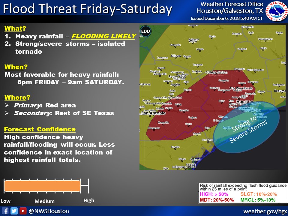
Houston area to see severe weather, potential flooding Friday and Saturday, Dec. 7-8

The National Weather Service forecasts heavy rain for the Houston area beginning Friday, Dec. 7, with the potential for flash flooding beginning in the afternoon hours.

The NWS Houston-Galveston branch released a briefing Dec. 6 detailing the storm, which is expected to bring 2-6 inches of rain to the majority of the Greater Houston area, with some localized areas receiving 8-10 inches. The area is under a flash flood watch.


https://communityimpact.com/houston/the-woodlands/public-safety/2018/12/06/houston-area-to-see-severe-weather-potential-flooding-friday-and-saturday-dec-7-8/

Severe weather shelters opening across Puget Sound region

As the cold snap continues, cities and counties in Western Washington are opening up their severe weather shelters.

Seattle's Human Service Department is opening a shelter Thursday night. Salvation Army will operate the shelter for adults 18 and older at the Seattle Municipal Tower. The shelter will operate from 7:30 p.m. to 6:30 a.m.

Thurston County Public Health and Social Services issued a "Code Blue" advisory to increase shelter capacity through 7 a.m. on Friday. Expanded shelter options are available at the Salvation Army and Union Gospel Mission for single men and women. Family Support Center's Pear Blossom Place is available for families with children needing shelter. Community Youth Service is available for adults ages 18-24.

There are four severe weather shelters in Kitsap County. Gateway Fellowship in Poulsbo, Port Orchard United Methodist Church in Port Orchard, and Silverdale United Methodist Church in Silverdale are open from 6 p.m. to 7 a.m. The shelter at Village Green Community Center in Kingston is open from 6:30 p.m. 6:30 a.m.

Lynnwood's severe weather shelter is open to families and individuals. Everyone in need of shelter are asked to meet outside of Lynnwood City Hall by 7 p.m. for transport to a local shelter facility. An additional shuttle stop is located in the Trader Joe's parking lot at Highway 99 and 196th Street SW.

Overnight temperatures are again expected to drop near or below freezing overnight Thursday. Temperatures will dip into the mid- to upper-teens for some areas. It will be in the 20s in most other areas around Western Washington, except for Seattle, where temperatures will be in the 30s, according to the Weather Service.

The cold snap we're experiencing is expected to continue through Friday

Storm to sweep through southern US with flooding, severe weather Friday to Sunday

A multifaceted storm will unleash flooding rainfall and localized severe weather across the southern tier of the United States beginning on Friday.
While the Deep South will escape the snowy, icy side of the storm, disruptions due to rain and flooding are likely along the Interstate 10 and I-20 corridors.
Airline passengers at the major hubs of Dallas, Houston, New Orleans and Atlanta can face significant delays. Ripple-effect delays can spread elsewhere across the country.
Very heavy rainfall and flooding will be a big threat with this storm, according to AccuWeather Meteorologist Ryan Adamson. 
Most areas from the lower Mississippi Valley to the southern Atlantic Seaboard received above-normal precipitation during the month of November, leaving the ground saturated and making it harder for additional rainfall to soak in.
Soaking rain will first gather over central, southern and eastern Texas and spread into southern Arkansas and northern Louisiana on Friday and Friday night.
“Cities that may experience enough rain for travel difficulties and flash flooding include Dallas, Houston, Austin and San Antonio, Texas; Little Rock, Texarkana and Pine Bluff, Arkansas; and Shreveport, Louisiana,” said AccuWeather Senior Meteorologist Alex Sosnowski.
While greatest risk to lives and property will be from flooding, feisty thunderstorms that can inflict damage cannot be ruled out. 
Fri-Fri night storm snapshot 12.6 AM

Wednesday, December 5, 2018

Connecticut Preps for Weather Extremes, Flooding Highlighted in Climate Report

Barrett's lessons are fitting for the Northeast region, which faces seasonal shifts, extreme weather, sea level rise, erosion, increased flooding and higher risks of diseases — including West Nile virus and Lyme disease — carried by fleas, ticks and mosquitoes, according to a stark U.S. climate report released on Nov. 23.

"All the predictions are essentially worse," Barrett said. She noted an increase in unusual weather events, such as an October nor'easter that caused coastal flooding, and a rise in what she called "sunny day flooding," which occurred during the most recent full moon, inundating roadways and the entrance to Bluff Point State Park in Groton. "Flooding and coastal erosion are moving up to the forefront," she said. "People are seeing that flooding doesn't have to come from a major storm. And people are starting to say, 'What are we going to do about this?' Nobody's ready to retreat, so we have to really think about what we're doing."

Issued by 13 federal agencies, the climate assessment projected that by 2035, the Northeast — encompassing New England and New York, Pennsylvania, New Jersey, Maryland, Delaware and West Virginia — would become more than 3.6 degrees warmer on average than during the preindustrial era. The increase would be the biggest temperature rise in the contiguous U.S. "and would occur as much as two decades before global temperatures reach a similar milestone," the report said.

"We used to have spring. We used to have fall," Lessor said. "Now it just seems as though you go from winter to early summer. We certainly seem to go from summer straight into extreme coolness."

Not every winter will be warmer, Lessor noted, but on average winters will continue to be warmer as they have for the last 20 years. The state could more often see food crop loss due to early bud break, like the loss of the peach crop in 2016, he said. Ski areas may have to rely on more artificial snow, an expense that could translate into higher ticket prices, he added.


Charlotte could get 8 inches of snow this weekend, National Weather Service predicts

Charlotte can expect 6 to 8 inches of snow this weekend, the National Weather Service predicted Wednesday, while cautioning that forecast totals will change in the days ahead.

Even higher amounts are predicted to fall west, north and northeast of Charlotte, according to an early snowfall forecast map issued at 5 p.m. by the NWS office in Greer, S.C.

The season’s first Charlotte area snowstorm could be a doozie, with a foot to 18 inches of snow predicted in Statesville, Hickory and LIncolnton, 8 inches to a foot in Gastonia and Salisbury, and 4 to 6 inches in Monroe, according to the NWS map.


https://www.charlotteobserver.com/news/local/article222683370.html

Could 'mega-fires' push California cities on the world's most polluted list more often?


The United States ranks as one of the countries with the lowest air pollution, but the country could see an opposite trend if monster wildfires become the new norm as the recent U.S. government climate assessment indicates.
The Camp Fire, which recently became the most deadly and destructive wildfire in California history, bumped three of California's cities on the list of the most polluted cities in the world on Nov. 16.
San Francisco, Sacramento and Stockton were briefly ranked as the world's three most polluted cities during the wildfires, according to Berkeley Earth, a nonprofit that collects data from air-quality monitoring sites.
Countries that often top the list for poor air quality levels include India, China and Bangladesh.
Air pollution in India is due to population growth, increase in the numbers of vehicles, use of fuels, poor transportation systems, poor land use patterns, industrialization, as well as ineffective environmental regulations.

Eherts said investing in in-home air purifiers and smoke masks can also help to limit the health impacts of poor air quality when wildfires spark nearby.
Wildfire smoke includes particles from burning vegetation and building materials mixed with gases. Toxins and fumes are added to the harmful mix when other things burn, like plastic from house fires
All of those particles could affect the people's health such as respiratory system and eyes, especially if somebody already has underlying respiratory problems, like asthma, emphysema, COPD. Smokers could also be affected.
According to Angel Waldron, a spokesperson for the Asthma and Allergy Foundation, air pollution can worsen asthma symptoms, and it is also connected to the development of asthma.


Photos: Severe weather generates record-setting December tornado outbreak for Illinois

over the weekend.

A swarm of tornadoes rocked central Illinois on Saturday, making it one of the most violent December days in the state’s history.

There were 26 confirmed tornadoes in the state, according to the National Weather Service in Lincoln, Illinois. This breaks the previous December tornado record in Illinois of 21, which occurred on Dec. 18-19, 1957.


In Taylorville, all non-residents were urged to avoid the town due to severe storm damage and closed roads, according to the Illinois State Police.

“All residents of Taylorvillle are urged to stay in their homes and off the streets as first responders respond to multiple calls,” the state police said on Twitter.


Over 1,400 flights canceled on busy travel Monday amid stormy weather

Over 1,400 flights were canceled on this post-Thanksgiving Monday as a dangerous snowstorm tore through the Midwest before heading to the Northeast as rain.

Airlines were forced to cancel over 1,200 flights on Sunday as snow blanketed parts of the Midwest on the busiest travel weekend of the year.

Airlines are now overloaded as the cancellations bleed into Monday -- and heavy rain is hitting Northeast airports, making matters worse.

There have been 1,468 Monday flight cancellations so far, with Chicago's O'Hare International Airport feeling the brunt of the impact with 1,189 of the day's cancellations. 


Transcript for 1 person dead, dozens injured as tornadoes slam Midwest

We'll move on now to that deadly tornado outbreak in the midwest. This twister right here, nearly one of two dozen reported in the region. One person was killed and at least 30 others injured as those twisters tore through the midwest and south. Ginger is here with those details. Good morning. Good morning. 15 of those confirmed tornadoes was in Illinois and that will end up their second largest outbreak in the month of December, but it's not over this morning. Tornado warnings happening now in Florida. Reporter: A violent weekend. For the love of god, please miss that farm. Reporter: 27 reported tornadoes from Oklahoma to Illinois to Georgia just last night. A tornado injured four people at the king's bay submarine base. High water rescues. Look at taylorville, Illinois. An ef-2 tornado, winds up to 130 miles per hour swept through. This home collapsed. That's just one of more than a hundred homes destroyed. It's on the ground. Reporter: In Havana, this storm swallowing the daylight. We're close to this. Reporter: In bluff city, whipping up debris less than 100 yards from the road. You can see debris going up through the air. Reporter: And in Oklahoma, an ef-2 tornado flipping boats, mangling buildings, dangling trees. The storm was deadly. One man was killed when an ef-1 with winds more than 100 miles per hour struck this Aurora motel. We have those severe thunderstorm warnings and tornado warnings from Georgia through north Florida and that's all along that same front. The strong storms should continue today and that will become potential for flash flooding and it will eventually die out tomorrow. George? Thanks. We move to the recovery efforts

https://abcnews.go.com/GMA/News/video/person-dead-dozens-injured-tornadoes-slam-midwest-59570995

Storm set to bring heavy rain to Southern California before moving east

A slow-moving storm system continues to bring rain to California’s coastal cities and snow to the mountains.

As the storm gets closer, heavy rain is expected Wednesday afternoon from Los Angeles to San Diego with some flash flooding possible. Also, ahead of the storm, gusty winds near 70 mph have been reported in Southern California.

There is further concern for mudslides near Malibu, California, where the Woolsey Fire burned through thousands of acres last month. This is the second rain storm to hit the region since the fire.

Heavy rain will continue on Thursday afternoon as the low near the coast, especially near San Diego, with a threat for flash flooding in the area.

Rainfall totals will range from 1 to 2 inches for Southern California on Wednesday and Thursday, while the Sierra Nevada Mountains will see an additional snowfall total near half a foot. Some snow is also possible outside of Los Angeles in the mountains.

The storm moves into the Gulf Coast on Saturday with heavy rain and strong storms to the south and heavy snow and ice from Texas to Oklahoma into Arkansas. Significant ice and snow accumulation is expected for the Southern Plains and Mid-South.

This same storm system moves into the Southeast and onto the East Coast by the end of the weekend into next week, bringing possibly significant snow and ice accumulation to the Carolinas and parts of mid-Atlantic.


https://abcnews.go.com/US/storm-set-bring-heavy-rain-southern-california-moving/story?id=59619185

Wednesday, October 10, 2018

Eyewall of Hurricane Michael Is Coming Ashore on Florida Panhandle, Life-Threatening Storm Surge, Catastrophic Winds Imminent

At a Glance
  • Michael is expected to make landfall along Florida's northeastern Gulf Coast Wednesday afternoon.
  • A Category 4 or stronger hurricane has never made landfall in the Florida Panhandle.
  • Catastrophic storm surge and destructive winds will occur near the landfall in the Florida Panhandle.
  • Over a million power outages will occur not just near the coast, but also inland after landfall.
  • Rainfall flooding is also a significant threat inland into the Carolinas.
Wind
- Hurricane-force winds (74-plus mph) and tropical-storm-force winds (39-plus mph) are spreading onshore in the hurricane warning area on the northeastern Gulf Coast.
- Hurricane-force winds will also spread well inland across portions of the Florida Panhandle, southeastern Alabama and southwestern Georgia.
- According to the National Hurricane Center, Category 4 winds in the eyewall of Michael are capable of catastrophic damage, including severe damage of well-built framed homes, many trees snapped and uprooted blocking numerous roads.
- Tropical-storm-force winds are expected to arrive in the tropical storm warning area along the southeastern U.S. coast by late Wednesday.

Rainfall

- Rainfall totals of 4 to 8 inches are forecast from the Florida Panhandle and Big Bend into southeastern Alabama and southwestern and middle Georgia, according to the National Hurricane Center. Locally, up to a foot of rain is possible. This may cause life-threatening flash flooding in some areas.
- The rest of Georgia, the Carolinas and southern Virginia may pick up 3 to 6 inches of rain, potentially triggering flash flooding. Locally, up to 8 inches is possible. This will include some areas devastated by flooding from Hurricane Florence. That said, this system will move quickly rather than stall like Florence did and will, therefore, not bring extreme rainfall amounts.
- The Florida Peninsula, eastern mid-Atlantic states and southern New England coast may see 1 to 3 inches of rain.

Tornadoes
- As is typical with landfalling hurricanes, isolated tornadoes will be a threat on the eastern side of the storm.
- A tornado watch has been issued for portions of northern Florida and southwestern Georgia until 5 p.m. EDT.
- Wednesday and Wednesday night, the tornado threat will be in play mainly from parts of north Florida to south and middle Georgia and southern South Carolina.
- Thursday and Thursday night, that tornado threat spreads into the coastal Carolinas.

https://weather.com/storms/hurricane/news/2018-10-10-hurricane-michael-cat4-historic-landfall-gulf-coast-florida