Showing posts with label Sierra Parham-Gantt. Show all posts

Monday, November 16, 2015

Colorado Blizzard


Colorado, Nebraska and Kansas will experience blizzard condition with heavy snow and strong wind gusts. This is the second storm that hit the areas in less than a week. It is forecasted to bring about approximately a foot of snow, with an inch or two falling every hour. The wind gusts can get up to 50mph. The storm will move eastward on Tuesday. This storm will cause significant complications for those traveling. It is expected to produce slippery and decreased visibility, which can become dangerous. The temperatures are going to drop to the single digits. Temperatures are expected to increase and melt most of the snow during the middle of the week. 
 

Sunday, November 8, 2015

East and West States Switch Temperatures for a Week

Widespread Snowfall Whitens Western US

This week in the western United States, it snowed from Wyoming to New Mexico. It was partly due to the areas having the coolest temperatures since April. “Montana's Big Sky Resort received 20 inches of snow through Wednesday afternoon. Another 13 inches of snow covered Yellowstone National Park, and a daily record of 9.9 inches was measured in Flagstaff, Arizona, on Wednesday. The previous record was 5 inches set in 1926.”

While on the east coast, the states saw record highest in temperature, especially in Florida (as high as 92 degrees Fahrenheit). It was 80 degrees Fahrenheit in Philadelphia.

Most of this weather can be attributed to the strong shift in the El Nino.

Tropical Cyclone Chapala


Tropical cyclone Chapala formed in the Arabian Sea and made landfall in Yemen on Tuesday November 2, 2015. It is the second strongest cyclone on record in the Arabian see. The lowest pressure recorded for Chapala was 922mb, which the first strongest cyclone’s, Gonu, pressure was 920mb. At its peak, Chapala was the equivalent of a Category 4 hurricane.

Three people were killed as a result of the cyclone Chapala and 700 homes have been damaged or destroyed. 

 
"Tropical Cyclone Chapala batters Mukalla, Yemen, on Monday, Nov. 2, 2015. The day before, the rare and rapidly intensifying cyclone killed one person and injured nine Sunday on the remote Yemeni island of Socotra as it moved toward the Yemeni mainland, local security officials said." (AP Photo/Mohammed Bazahier)

Potential Storm Brewing near Bahamas


A storm forming in the Atlantic near the Bahamas can turn into a tropical cyclone within the next couple of days. The wind shear will be low and the water temperatures are warm enough to be favorable for growing development. “Such conditions could cause the low to become the first tropical depression in the Atlantic since Joaquin hit a month ago.”

It is expected to curve away from the United States by Tuesday. This hurricane season has seen ten tropical storms and three hurricanes—only two of which became major hurricanes. These data are below the average for this time of they year.

Aurora Lights


A rare occurrence of aurora borealis, also known as the northern lights, was seen across Canada and northern United States this week. In the Southern Hemisphere a display of southern lights, known as aurora australis, could also be seen. Auroras are lights that are caused by a “spray of charged particles from the sun interacting with Earth’s magnetic field.” Another event occurred in this past October. I missed both views, unfortunately.

  
Iowa: aurora, jets, meteorites 
 
Michigan view

Sunday, November 1, 2015

Comet size of Skyscraper misses Earth


A dead comet was just discovered earlier this month and is estimated to be about the size of a skyscraper. It shot past Earth on Halloween, at dangerously close proximity.  It is a dead comet, which indicates that it doesn’t have a tail. This comet is 2,000 ft in diameter, which is larger than the Empire State Building. Although it is smaller than the asteroid that causes the dinosaurs to go extinct, if it were to hit Earth, it would cause substantial damage to the lives and properties of those in the effected areas. “Fortunately, the comet will miss the Earth, but it still made an uncomfortably close approach of 302,885 miles. To put this in perspective, the average distance from the Earth to the moon is 238,900 miles.”

Sunday, October 25, 2015

Flooding from Hurricane Patricia


Texas, Louisiana Brace for More Life-Threatening Flooding as Patricia's Moisture Arrives
Parts of Texas have started to experience major flooding this weekend as a residual effect of the tropical moisture from both the Gulf of Mexico and ex-Hurricane Patricia.


One of the hardest-hit areas had rainfall totals exceeding 20 inches. “Much of Texas received between 4 and 8 inches of rain, leading to road closures, sporadic power outages and widespread flooding.” Another potential threat from the hurricane is isolated tornadoes that can form and hit the coast, like the one that touched down in Pearland, Texas. Even if flooding isn’t a threat, travel disruptions are likely to happen due to poor visibility and heavy rainfall. 
 

Warmer Winter for Canada


2015-2016 Canada Winter Forecast: El Nino to Promote One of Warmest Winters on Record

Canada is going to see the warmest winter on record this upcoming season due to a strong El Nino. The average temperature can get up to 5.5 degrees Fahrenheit above the typical temperatures for winter in Canada this year. A drier and milder weather is also predicted for the Prairie region this winter as the Polar jet stream gets “displaced farther to the north. This pattern will greatly limit the amount and duration of Arctic air masses that normally impact the region.” Due to this increase in temperature, there is an increased probability for ice storms. 


Hurricane Patricia: In Mexico


Hurricane Patricia was a category 5 hurricane that formed on Oct. 20, 2015 and fizzled out on Oct. 24, 2015 in southwest Mexico. “On Oct. 23, Patricia became the most powerful tropical cyclone ever measured in the Western Hemisphere.” the storm quickly increased in intensity. In 24 hours the winds increased from 85 mph to 200 mph, but just 24 hours later, they decreased to 75 mph. It’s central pressure was record breaking too, as it had risen 106mb in 24 hours, from 880mb to 986mb and decreased 100mb 24 hours later. Rainfall can get up to 20 inches in some areas of Mexico, which could cause life-threatening flash floods and mudslides.


Friday, October 9, 2015

Ex-Hurricane Oho


Remnants of Hurricane Oho to Bring High Winds, Heavy Rain to Southeast Alaska, British Columbia
 
Hurricane Oho became a strong non-tropical cyclone that formed over the central north Pacific Ocean. It is quickly moving north-northeast toward Alaska and British Columbia, which will cause severe weather in the area. It is a non-tropical cyclone because the water in the ocean isn't warm enough to support a tropical cyclone.

Portions of southeastern Alaska will see wind gusts of over 60 mph. Oho took a peculiar track to the northeast. “Although tropical systems do, on occasion, move to the northeast in the central Pacific, since 1949, no late season (October or later) system has formed south of Hawaii and moved to the northeast.” On average the central Pacific basin sees an average of 5 tropical systems in a given season compared to the northwest Pacific whose average is 26 systems.

Forecast Winds

Thunderstorms in the Southwest

Drenching Thunderstorms to Target Texas, New Mexico Into Friday
A thunderstorm  and flash flooding watch was issued this morning for near Albuquerque, New Mexico, and El Paso, Texas. The warm moisture from the Pacific will continue converge into the storm system and contribute to the widespread showers and thunderstorms. The rain will be beneficial in lowering the risk of wildfires; although, the storm system, by itself, will not be enough to impact drought conditions significantly. The storm system is predicted to southwestward over Baja California, Mexico into the weekend.

Thursday, October 1, 2015

The Picture Perfect Storm

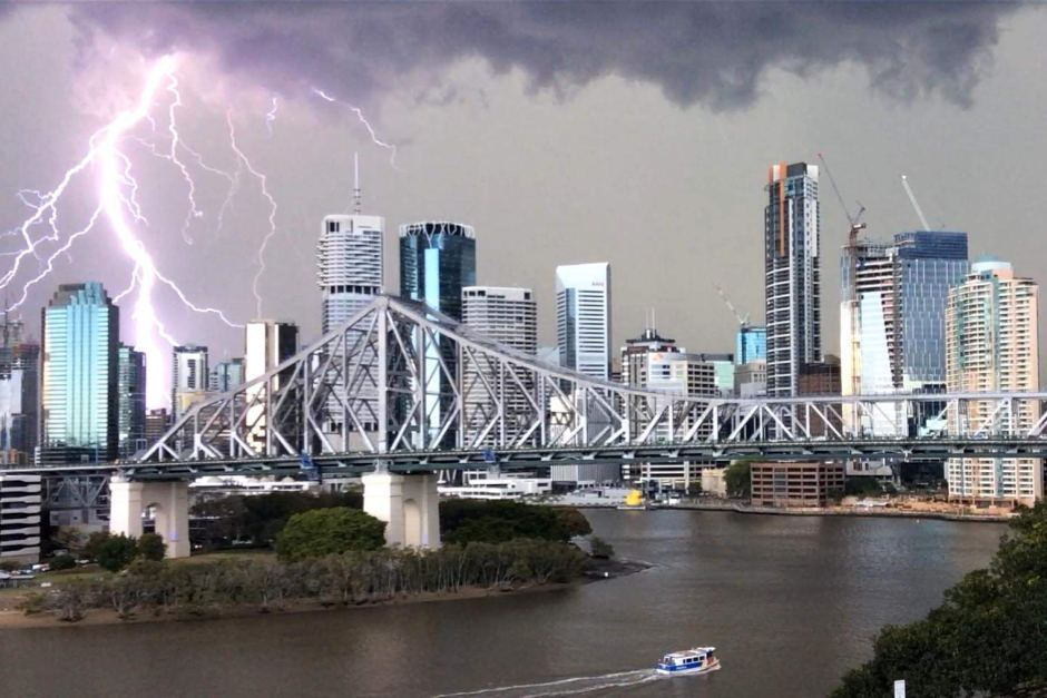
A thunderstorm hit Brisbane, Australia on Tuesday. It caused heavy rainfall and hail. Flights were delayed going into and out of the city. There were 10,000 lightning strokes. From what I observed at the museum about lightning, I am wondering the role of sprites in creating such a powerful storm. Approximately 5,000 homes lost power. There were more storm warning issued, but have since been cancelled. However, damaging wind and hail is still in the forecast. 

Higgins Storm Chasing shared this photo of hail that reportedly fell in Maleny on Wednesday afternoon.Embedded image permalink

Storm in Brisbane, Australia, Creates Apocalyptic Images

Hurricane Joaquin

Hurricane Joaquin is growing rapidly, heading north in the Atlantic Ocean. It is en route to hit the Bahamas with wind gusts of up to 120 mph. Flights to and from the Bahamas have been cancelled. This hurricane was category three yesterday Wednesday, September 30, but it is now being classified as a category four hurricane. South Carolina up into Massachusetts will experience residual impacts of the hurricane through Monday. It is expected that the east coastline will see heavy rainfall, strong winds of up to 40 mph, coastal flooding, and mudslides. There is a flash flood warning for the states along this area. In addition, road closing and power outages are predicted as a result of the hurricane.

 Meteorologists are unsure if it will hit the United States, but it is projected to decrease in intensity as it moves north. If it does hit land, it do so on Monday.
"Governors in Virginia, Maryland, New Jersey and North Carolina have issued a State of Emergency. Other states may follow suit."

http://vortex.accuweather.com/adc2004/pub/includes/columns/newsstory/2015/650x366_10011801_hd25-3.jpg
Major Hurricane Joaquin to Impact Over 65 Million From South Carolina to Massachusetts

Wednesday, September 23, 2015

Lunar Eclipse

A rare lunar eclipse will appear on Sunday, September 27, 2015 at 9:07pm EDT. It will be fully eclipsed for over an hour, but still visible for three hours. The moon will appear 14 percent larger. It will coincide with a supermoon, which is a harvest or blood moon that typically occurs around the beginning of fall. The moon will pass behind the Earth, into its shadow, causing a red tint on the surface. This event isn't expected to occur for another 18 years.

This eclipse will be best seen in the Plains, Midwest, and Southwest. While, the Atlantic storm in the east and cold front in the northwest may obstruct views due to cloud coverage.

Viewing Conditions: Supermoon to Coincide With Lunar Eclipse in Rare Celestial Event Sunday Night

Large Atlanic Storm Spanning the East Coast

An Atlantic storm moving slowly westward will affect around 600 miles along the east coast with approximately one to three inches of rain and gusty winds of up to 40 miles per hour. This storm could cause airline delays, poor visibility, coastal flooding, and beach damage. It will start in Georgia and head towards the Carolinas and eventually southern Virgina. These regions may start to see some flash flooding as well.

This storm may indirectly cause rain and thunderstorms in Florida. Currently in New England, there is dry air and high pressure, so once the storm travels north, it is undetermined whether it will head in New England or span out into the sea. Either way, the dry air will cause some rain to fizzle out.

The flow of air around the high pressure to the north and the storm itself will direct winds and ocean water toward the middle part of the East coast through this weekend.

Atlantic Storm to Pound 600-Mile Stretch of East Coast

Thursday, September 17, 2015

Most Destructive Wildfire This Year in California

California's Valley Fire Ranks as One of the Most Destructive in the State's History

A valley fire ignited Saturday near Cobb, California. It has destroyed about 73,300 acres thus far. It has consumed about 600 homes and hundreds of buildings. This wildfire is so destructive because it erupted so close to civilization and it spread 30,000 acres in just 24 hours. Although it isn't the largest wildfire this year, it is in the running to become the most destructive wildfire in California, yet it stands at ninth on the list currently. Firefighters have increased containment to 35 percent. This progress was partially assisted by the weather drop during the week. This fire has taken the life of one individual and injured four others.

Large Earthquake Causing Waves Worldwide

Deadly Earthquake Rocks Central Chile; Tsunami Reaches Southern California, Hawaii

An 8.3 magnitude earthquake hit the coast of central Chile on Wednesday evening. It was the third most powerful earthquake in five years and the largest worldwide since April of last year. This earthquake lasted three minutes; yet it was deadly. It killed ten people, and 135,000 went without power. There were dozens of aftershocks with the largest being a 7.0 magnitude. These aftershocks have caused landslides and even a tsunami in the Pacific Ocean. The tsunami waves were about 15.6 feet high in Chile and about 13 inches high near Ventura Harbor in California. There was also a tsunami wave about a foot high in Hawaii. Minor waves could even hit China and Japan Friday. New Zealand has also issued a tsunami warning.


Monday, September 14, 2015

Japan experiences Severe and Unusual Weather Diasters

This week has been quite interesting on the weather front for Japan. In the past week alone, they have experienced severe flooding, landslides as a result, and to top that all off, this morning, Japan experienced a moderate Earthquake.

Tropical Storm Etau Devastates Japan
The flash flood was a result of more than 20 inches of rainfall due to the Tropical Storm Etau. More than 13,000 homes were flooded. In addition, three people died, 16 people are missing, and 30 others were injured. This flood caused the levee to break north of Tokyo, causing 99 landslides. Over the weekend, there was a 4.6 magnitude earthquake in eastern Japan that caused very little damage and injury; but many had to evacuate their homes.

Mount Aso Erupts in Western Japan; Flights Disrupted
This morning Mount Aso, in western Japan, erupted ash, volcanic rock, smoke, and steam 6000ft into the air. This volcanic ash disturbe and delayed flights. No injuries or damages occurred as a result of the earthquake.


Saturday, September 12, 2015

Huge Ice Field Found on Mars


Subterranean Ice Field On Mars Larger Than California and Texas Combined
Scientists found a rare terraced crater on mars that revealed an ice field 130ft thick. This crater may be larger than the area of Texas and California combined. Ali Bramson suggests that Mars was hit with an object and its outer surface was weaker than its second layer, which in turn revealed the ice field beneath the surface. Knowing that Mars has ice beneath its surface provides us with details about Mars' past climate. Perhaps the most interesting this about the ice was that it was accumulated, buried, and preserved instead of sublimating into the dry Mars atmosphere.


 alt

Baseball-Sized Hail Struck Down in Italy

Baseball-Sized Hail Pummels Parts of Italy This Weekend
On Saturday in Pozzouli, Italy near Naples, base-ball sized hail fell down from thunderstorms at speeds of 75 mph. This hailstorm was as large and dangerous as the most destructive hailstorm in Munich Germany in the year 1958. This severe and unusual storm was caused by a strong southward surge of the jet stream. This hailstorm injured several people and animals and caused two billion dollars in damages.
alt
alt