Showing posts with label Tyree York. Show all posts

Tuesday, December 10, 2013

Seventh person dies after Illinois tornados

Viewer-Submitted Storm Damage Photos
Getty Images
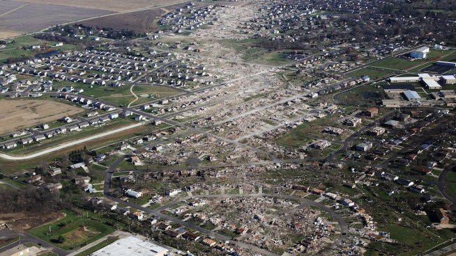
Tornado-damaged homes are seen on November 18, 2013, in Washington, Ill. The tornado that ripped across Washington was classified as an EF-4.
A seventh person has died from injuries sustained during the Nov. 17 tornadoes that swept through central Illinois.
Rosamund Allison, 82, was pronounced dead at 11:15 p.m. Thursday, the Peoria County coroner confirmed. Allison sustained multiple injuries when an EF-4 tornado hit her Washington home as it raked the small town. 
Family members told NBC affiliate WEEK-TV the tornado's winds pulled the woman from her home and dropped debris on her.
The tornado traveled 46.2 miles on the ground, forecasters said, leveling countless homes. Steve Neubauer, 51, was also killed and at least 122 were injured. Tornadoes were blamed for the deaths of five others across the state.
The coroner said an autopsy will be done Saturday.


Source: http://www.nbcchicago.com/weather/stories/Seventh-Person-Dies-After-Illinois-Tornadoes-233853271.html#ixzz2n6M6C2GQ

First big snowfall of season blankets chicago

Several delays were reported at area airports Sunday afternoon. O'Hare International Airport reported up to two-hour delays on some airlines and more than 140 cancellations for flights Sunday. Midway Airport reported more than a dozen flights were delayed up to three hours.
A traffic accident in Racine County, Wis., left all eastbound lanes of Interstate 94 blocked near Seven Mile Road, officials said. The crash, which took place at 10 a.m., shut down lanes for more than two hours. Traffic was being rerouted at Seven Mile Road and could enter again Highway 20, according to WisDOT.
One person was killed in another crash near Milwaukee.
A special weather statement was issued for LaPorte County, Ind., warning of light snow during the mid afternoon hours. The snow was expected to change to a period of freezing drizzle during the late afternoon and early evening hours.
"Anyone planning travel across the area this afternoon into tonight should be prepared for the possibility of slick roads," the alert stated.
Saturday's highs dropped into the teens, marking some of the coldest air to move into Chicago this season. The day started with wind chills below zero and those wind chills rose only into the single digits by the afternoon.
Temperatures were expected to fall into the single digits Monday, with those lows sticking around for much of the week.


Source: http://www.nbcchicago.com/weather/stories/Chicago-Could-See-Snow-Sunday-234599631.html#ixzz2n6Kt83Nh

Conditions ripe for awful Wednesday morning

Your December Snow Photos
Weather conditions on Wednesday morning will likely make for a morning commute full of delays, spinouts and crashes.
Another two to four inches of snow is expected to fall between 4 a.m. and 9 a.m. Wednesday with temperatures in the teens. Road salt is most effective to temperatures of roughly 20 degrees, meaning that any salt that is spread likely won't do all that much good.
In Chicago, the Department of Streets and Sanitation uses a mixture of sugar beet byproducts and liquid salt brine to make the salt work more effectively at lower temperatures.
Additionally, snow-fighting equipment out at that time will also be competing with increasing morning traffic as commuters head out to start their days.
Metra officials said preparations were already taking place to ensure commuters can get to where they need to go as smoothly as possible.
"We have heaters near critical switches to keep them warm and operational and prevent ice buildup, but some of them can be extinguished by high winds so our personnel have to watch for that," said spokesman Michael Gillis. "Of course if there is any accumulation of snow we will have people in the field to shovel and salt platforms, and we will be working to keep our yards clear so there are no problems getting trains in and out."
The snow should be completely out of the area by midday Wednesday, but that's going to be followed by some of the coldest air we've seen so far this season.


Source: http://www.nbcchicago.com/traffic/transit/chicago-weather-december-11-2013-235248951.html#ixzz2n6GKrq1Q

Tuesday, November 19, 2013

Typhoon Haiyan survivors plead for help


Typhoon-ravaged Philippine islands faced an unimaginably huge relief effort that had barely begun Monday, as bloated bodies lay uncollected and uncounted in the streets and survivors pleaded for food, water and medicine. Police guarded stores to prevent people from hauling off food, water and such non-essentials as TVs and treadmills, but there was often no one to carry away the dead -- not even those seen along the main road from the airport to Tacloban, the worst-hit city along the country's remote eastern seaboard.

At a small naval base, eight bloated corpses -- including that of a baby -- were submerged in sea water brought in by the storm. Officers there had yet to move them, saying they had no body bags or electricity to preserve them.
Two officials said Sunday that Friday's typhoon may have killed 10,000 or more people, but with the slow pace of recovery, the official death toll remained well below that. The Philippine military confirmed 942 dead, but shattered communications, transportation links and local governments suggest the final toll is days away. Presidential spokesman Edwin Lacierda said "we pray" that the death toll is less than 10,000.
Tacloban resembled a garbage dump from the air, punctuated only by a few concrete buildings that remained standing.
"I don't believe there is a single structure that is not destroyed or severely damaged in some way -- every single building, every single house," U.S. Marine Brig. Gen. Paul Kennedy said after taking a helicopter flight over the city. He spoke on the tarmac at the airport, where two Marine C-130 cargo planes were parked, engines running, unloading supplies.

Hurricane Season

Hurricane Season

Add this to:
del.icio.us Digg Reddit Facebook Newsvine
Tropical Update
Michael Lowry, Hurricane Specialist, The Weather Channel
Nov 18,  2013 2:18 pm ET
An area of low pressure that originated along a frontal boundary has separated from the front to become Subtropical Storm Melissa, the 13th named storm of the Atlantic hurricane season.
Melissa is a large storm, with tropical storm force winds extending 230 miles from the center. The storm is expected to move slowly northwestward and eventually northward before accelerating northeastward and out to sea by mid-week. Melissa could strengthen or briefly attain full tropical storm status as it remains over ocean waters in the mid to upper 70s but will quickly transition to an extratropical storm by late week as accelerates toward much cooler waters.
Melissa is no threat to the U.S. or any other land areas.

Severe Weather Affecting Millions

Illinois

  • At least 50 homes were destroyed by a possible tornado in Brookport, according to reports. Search and rescue operations occurred in that town on Sunday afternoon and evening. WPSD reported that there was “massive devastation” in Brookport, with gas leaks and downed power lines. Mayor Dave Mingus tells NBC News that approximately 100 houses are damaged and that 25 to 50 of those are uninhabitable.
  • More than 80,000 customers were without power on Sunday, most of them in Peoria.
  • Severe damage was reported in Pontiac and northeast of Champagne.
  • At least one tornado hit portions of Washington and another touched down in Pekin, authorities confirmed. The Peoria Journal Start reported that Georgetown Commons apartment complex in Washington was severely damaged and other areas were hit hard. Authorities were doing a house-to-house search.

Indiana

  • Kokomo police asked residents to stay home and off the streets after city officials declared a state of emergency in the wake of severe storms.
  • The town of Kokomo has declared a state of emergency through Monday morning. Schools will not be open on Monday.
  • Gov. Mike Pence says the cities of Washington in southwestern Indiana and Lebanon in central Indiana have sustained significant damage and that 12 counties either reported tornado touchdowns or storm damage.
  • Indiana State Police Sgt. Kim Riley says a teacher has been injured after the storm heavily damaged a school south of Lafayette.
  • The NWS says a trained spotter reported a tornado along Interstate 74 near State Route 63 in northern Vermillion County on Sunday afternoon. It also reported power lines down in adjacent Fountain County.
  • Vermillion County Sheriff's Department Director of Communication Derrek Williams reported widespread damage in the northern part of the county, about 60 miles northwest of Indianapolis.


    Michigan

    Friday, November 15, 2013

    Snow to bring slippery travel to Northwest rockies

    Play video
    Snow and locally gusty winds will spread rapidly across Washington, Idaho, Montana and Wyoming this weekend, making for slippery travel.
    The some of the heaviest snow is forecast to fall on Snoqualmie and Lookout passes along I-90 in Washington and Montana, respectively. Motorists traveling through these areas should expect delays and restrictions due to 6 to 12 inches of snow with blowing and drifting.
    Motorists who must travel cross country may want to take a more southern route such as I-84 to I-80.
    Most of the snow will fall over the mountains in the Northwest and northern Rockies, but not all of it.

    What made the Halloween nor'easter of '91 the perfect storm?

    While these conditions are rare, this was not a one-time occurrence. The storm's iconic name and its popularity in film and literature have greatly helped make this storm stand out the most, but according to Kottlowski, storms from such conditions have occurred since then.
    Satellite image of the Perfect Storm. Photo courtesy of Wikimedia Commons.
    "It's rare for a tropical and a non-tropical system to join," he said. "But these conditions are favored this time of year. Late October to early November southern Atlantic waters are still warm enough for a tropical system, but cold air is already coming down from Canada. It's the right time for these systems to meet."
    The Gale of 1878, for example, was created with similar conditions. In late October a tropical system moved out of the Keys northward along the East Coast, bringing 4.5 inches of rain to Cape Hatteras, N.C. By the time the storm reached Philadelphia, it met with a cold air system. The result was hurricane-force winds on Oct. 23 in the city and its surrounding areas, up to 72 mph. Estimates gauge that from 500-700 buildings were destroyed.
    Superstorm Sandy was another similar storm, since it was part tropical and part nor'easter.

    Super typhoon death toll could reach 10,000

    Official: Super Typhoon Death Toll Could Reach 10,000

    By Eric Leister, Meteorologist
    November 13, 2013; 8:45 PM
    Play videoWeather across Asia is detailed in the above AccuWeather.com video.
    In the wake of once-Super Typhoon Haiyan (local name Yolanda), the death toll has climbed to over 3,600 with more than 12,000 injured and more missing according to the Philippines government.
    A senior regional police official and a city administrator in the typhoon-ravaged Tacloban city in the central Philippines say the death toll there could reach 10,000 people as reported by the Associated Press.
    Most of the deaths have been caused by drowning and collapsed buildings. However, it is feared that the coastal cities will have even more casualties. With wires, trees and debris cutting off access to these areas, aid has been struggling to reach victims and unable to determine a final death toll.
    Tacloban was "ground zero" for Haiyan's devastation, stated AccuWeather.com Meteorologist Eric Wanenchak. CNN reports that no building in Tacloban appeared to have escaped damage from Haiyan.

    Climate change debate rages on in Haiyan's Wake

    Climate Change Debate Rages on in Haiyan's Wake

    By Jillian MacMath, AccuWeather.com Staff Writer
    November 15, 2013; 11:29 AM
    In the wake of Super Typhoon Haiyan, the issue of climate change and stronger storms has once again reared its head in the scientific and political community. (Photo/EU Humanitarian Aid and Civil Protection)
    Just days after Haiyan made landfall in the Philippines, the 2013 UN Climate Change Conference kicked off in Warsaw, prompting a big message from Philippines delegate Yeb Sano.
    At the opening of the two-week conference, Sano vowed to fast voluntarily until a "meaningful outcome" was in sight, in solidarity with those who do not have food in the wake of Haiyan.
    @a_b_world tweeted: "WMO says Typhoon Haiyan is climate 'wake-up call'http://bbc.in/HMpfkq #environment #climate #cdnpoli #sustainability #co2 #eco #health"
    "What my country is going through as a result of this extreme climate event is madness," he said at the conference this week.
    "Typhoons such as Haiyan and its impacts represent a sobering reminder to the international community that we cannot afford to procrastinate on climate action."
    The country has been a center for natural disasters over the past year. Since June, the Philippines were in the direct path of typhoons Nari, Utor and Krosa, which moved over the northern island of Luzon.

    Monday, October 7, 2013

    Flooding forces evacuations in Louisville

    Flooding late Saturday into early Sunday forced more than 80 people to be evacuated from parts of Louisville, Ky., emergency officials said.
    Most of the flooding came from Beargrass Creek and evacuations took place in four sections of the city, according to the Louisville Emergency Management Agency Facebook page.
    Heavy rainfall generated ahead of a slow-moving cold front broke two records in Louisville Saturday. One of those records included one that was a century-old.
    It was the wettest Oct. 5 on record with 5.91 inches of rain, the National Weather Service forecast office in Louisville reported. The previous record was 3.1 inches, set in 1910.
    The rain also broke the all-time daily record for October, clobbering the previous mark of 5.07 inches of rain on Oct. 18, 2004.
    At least 45 roads were closed late Sunday morning, according to the Louisville Metro police.

    Gusty Storms, Rain to End Unusual Warmth in East

    Thunderstorms with potentially damaging winds will aim for New England Monday night.
    Some of Karen's moisture will get drawn northward and enhance the rain accompanying a cold front spreading into the mid-Atlantic and Northeast. This is despite Karen weakening into a tropical rainstorm in the northern Gulf this past weekend due to dry air and disruptive winds above the surface of the water.
    "One to 3 inches of rain will occur near and along the front as it works eastward across the eastern United States," AccuWeather Expert Senior Meteorologist Dan Kottlowski said.
    There is also the risk of a couple of brief, spin-up tornadoes into Monday evening. These could be concealed by drenching rain in some cases right along the mid-Atlantic coast and over New England.

    Midwest pounded with autumn storms producing snow


    Blizzards rolled into parts of Wyoming and South Dakota on Friday, bringing the snow-savvy states to an unseasonably early winter standstill and forcing a tourist town to cancel its annual Octoberfest's polka-dancing bar crawl.

    The storm dumped 33 inches of snow in a part of South Dakota's scenic Black Hills near Lead, "and it's still coming down," National Weather Service meteorologist Eric Helgeson said Friday afternoon.
    Wind gusts reached as high as 68 miles per hour just outside the weather service office in downtown Rapid City, where 8 inches of snow had accumulated, Helgeson said.
    In northwest Nebraska, three people were killed in an accident on snow-slicked U.S. 20 Friday morning, authorities said. The storm system also generated a tornado in Nebraska, blanketed Colorado's northern mountains with snow and was threatening to push strong thunderstorms as far east as Wisconsin. Forecasters said the cold front would eventually combine with others to make for a wild, and probably very wet, weekend for the central U.S. and Southeast.
    Julie Lee said she and fellow members of her White Rose Band were accustomed to snow, just "not for the fourth of October." They had barely unloaded their instruments in South Dakota's Old West casino town of Deadwood before the wet, heavy snow started falling and closed part of Interstate 90, the area's only interstate.
    "Our car is like an igloo," said Lee, who sings and plays the clarinet and saxophone for her North Dakota-based polka band. "I'm glad we got everything out."

    Tornadoes in October, November

    Spring is known for its strong storm system that can create violent twisters. However, it's not the only season known for tornadoes. Autumn is considered the "second" tornado season.
    (MORE: Today's Severe Storm Threat)
    "The second half of October and especially November can often be a second season for tornadoes and severe thunderstorms," said tornado expert Dr. Greg Forbes. "In many ways, this is the counterpart to spring, when strong fronts and upper-air systems march across the United States. When enough warm, moist air accompanies these weather systems, the unstable conditions yield severe thunderstorms and sometimes tornadoes."
    While most of the largest tornado outbreaks still occur in spring, autumn has its share of storms as well. Dr. Forbes examined the storm statistics and found six of the largest 55 known tornado outbreaks occurred in October and November.
    (INTERACTIVE MAP: Radar, Watches, and Warnings)
    May is still the peak month for tornadoes. Up to 52 percent of September's tornado outbreaks are due to landfalling tropical storms and hurricanes. October and November's tornadoes are caused by strong cold fronts and low pressure systems affecting the South and sometimes the Midwest.
    So far, 2013 is on pace to be a record low tornado year. January was the only month that's been above average for tornadoes. It had 74 tornadoes, 2.3 times the average number of tornadoes.

    Read more at http://www.wunderground.com/news/fall-second-tornado-season-20131002#x2jst4vsKWgjuCOR.99

    New York City Tornado Watch

    Parts of the New York City metro area were placed under severe thunderstorm warnings as a storm system moved through the Big Apple on Monday afternoon, dumping plenty of rainfall and producing some incredible images as dark clouds rolled overhead.
    Christian Brock
    A photo taken from Hoboken, NJ shows the menacing skies.
    The same system knocked out power for about 12,000 customers in eastern New York. Downed trees caused headaches for commuters on NJ TRANSIT.
    (MORE: Check the Upcoming Severe Threat)
    Before the storms unleashed sheets of rain, a few moments of nearly pitch-black skies gave NYC residents enough time to snap pictures of a rare strong thunderstorm, and we collected some of the best photos and videos below.

    Read more at http://www.wunderground.com/news/new-york-city-storm-photos-20131007#B7fGvItwTYM6d4o8.99

    South Dakota blanketed by several feet of snow as storms hit Great Plains

    South Dakota snow storm
    A shopper wades through a large snow drift in downtown Rapid City, South Dakota. Photograph: Chris Huber/AP
    In the span of 24 hours, the scenic Black Hills in South Dakota were coated in up to three and a half feet (1.1 meters) of wet, heavy snow. South Dakota is one of several Great Plains states to have been hit hard by a storm system that has caused millions of dollars in damage.
    A National Weather Service meteorologist, Katie Pojorlie, said the snow was expected to end later on Saturday, giving people a chance to start digging out from the unusual, record-setting early fall snowstorm.
    But wintery weather wasn't the only thing wrapped into the powerful cold front, as thunderstorms brought heavy rain, hail and as many as ninetornadoes to Nebraska and Iowa. Fifteen people in northeast Nebraska were injured in a tornado on Friday, and three died in a car accident on a snow-slicked Nebraska road.
    Forecasters said the front would eventually combine with other storms to make for a wild and probably very wet weekend for much of the central and south-eastern US.
    Power outages and impassable roads plagued western South Dakota on Saturday. More than 25,000 people lost power in the Rapid City area, and authorities were recruiting snowmobilers to help rescue about 80 motorists who had been stuck in their vehicles overnight. A Pennington County emergency management spokeswoman, Alexa White, said the stranded motorists turned on their cars at times during the night, in order to stay warm. The rescue efforts, she said, were slow-going, because "the only way to get there is the snowmobiles or the Sno-Cats". "The plows have gotten stuck in the roads," she said.

    Government Shutdown Affects Weather, Climate Programs

    With the federal government shut down for the first time in 17 years, many of the nation’s weather forecasters remain at work, but longer-term climate research is taking a hit. According to Commerce Department documents, 6,601 of the 12,001 employees of the National Oceanic and Atmospheric Administration (NOAA) -- or 55 percent of the agency's workforce -- have been sent home without pay. That leaves 5,400 “excepted” from the shutdown, mainly because they are needed for the protection of life and property. 
    NOAA and NASA satellites will continue operating during the government shutdown, but the public may have trouble accessing images as websites are not maintained.
    Credit: NASA.

    In particular, the National Weather Service will continue operating its network of 122 local forecast offices to provide weather forecasts, watches, and warnings, and NOAA will also continue to operate its weather and climate computer models, as well as satellite data feeds to ensure that forecasters have uninterrupted access to weather information.
    But while the weather service forecast offices are open, employees are not allowed to engage in their typical full range of activities, according to a NWS meteorologist.
    “We are restricted to 'mission critical' duties. We aren't allowed to engage the public in outreach activities (such as spotter talks or school talks), and we're supposed to only include forecast-critical information on Facebook and Twitter accounts," the meteorologist told Climate Central, speaking on the condition of anonymity because they were not authorized to talk to the media about the shutdown. "Only emergency equipment maintenance is allowed, which means that routine maintenance is not. This will hamstring us in the future, either when the shutdown is lifted and the rush of delayed work hits or when equipment breaks because it is not being maintained properly,” the meteorologist said.

    NWS Staff Walks to Work in Blizzard Despite Shutdown

    During the government shutdown, the 122 National Weather Service (NWS) forecast offices across the country are still operating, issuing potentially life-saving forecasts and warnings. "Neither snow nor rain" is part of the unofficial motto of the U.S. Postal Service. However, NWS employees in Rapid City, S.D. seem to have taken that motto to heart.
    The record snowstorm in Rapid City, S.D. buried this Dodge Durango truck. 
    Credit: @MsXtine/twitter

    Like most other federal workers during the shutdown, the NWS meteorologists are not getting paid right now, and are hoping to receive back pay for work performed during this period. Not only are the meteorologists working for no pay, at least temporarily, but they’ve had to deal with some truly exceptional weather conditions this past weekend that have posed forecasting challenges and even put them in harm’s way.

    A record-breaking early season blizzard struck a number of states from the northern Rockies to the Northern High Plains on October 4-5, dumping as much as 4 feet of snow and piling the snow into drifts up to 10 feet high in places. Those conditions created hurdles for NWS staff that would be tough to surmount under any circumstances, least of all during a government shutdown when offices are short-staffed and support services, such as technical support from NWS headquarters, are stretched thin.

    Below is a message sent from the NWS forecast office in Rapid City to the NWS Central Region Headquarters in Kansas City, Mo. on Sunday morning at 9:09 Central Time. This was sent to Climate Central from an NWS meteorologist who was not authorized to share any information related to the government shutdown, and some of the details contained within the message were confirmed with a staff member from the Rapid City office on Monday morning. The employee said the message speaks to the "dedication" of the NWS staff during the shutdown.

    Thursday, September 12, 2013

    Record heat


    The record-breaking temperatures scorched parts of the Plains on SundayWichita, Kan. (101),McCook, Neb. (105) and North Platte, Neb. (101) were among the cities that either tied or broke daily record highs for Sept. 8.
    In Des Moines, IowaMonday became the latest 100-degree day on the calendar in records dating back to 1878, and tied the city's all-time September record high of 101 degrees. Their previous latest triple-digit day in a calendar year was Sept. 7 back in 1939; that day also hit 101 degrees.
    Highs surged well into the 90s Monday in cities from Minneapolis/St. Paul and Chicago to St. Louis,Kansas City, and Omaha, Neb.
    Tuesday brought a slew of record highs:
    Although the hot temperatures will persist Wednesday from the southern Great Lakes to the central Plains, you can see the signs of changes ahead as cooler air nudges its way southward. St. Louis and Indianapolis will flirt with record highs.
    http://www.weather.com/news/weather-forecast/record-heat-midwest-des-moines-chicago-20130909

    Hurricane Watch


    Background

    Storm Information

    Storm Information

    Current Inform

    So, where exactly is the cyclone's center located now? If you're plotting the storm along with us, click on the "Current Information" map below to get the latitude/longitude coordinates, distance away from the nearest land location, maximum sustained winds and central pressure (measured in millibars).  

    Satellite

    How does the system look on satellite imagery. Click on "infrared" satellite imagery, to see how "cold" the cloud tops are. Brighter orange and red shadings concentrated near the center of circulation signify a healthy tropical cyclone.


    Background

    Latest Radar

    Latest Radar

    South Texas Radar

    How much rain is wrapping into South Texas? We have the latest radar image at left. Click on the link below the map to use our interactive radar of Deep South Texas.


    Background

    Watches/Warnings

    Watches/Warnings

    Tropical Storm/Hurricane Watches/Warnings

    A tropical storm or hurricane watch means tropical storm or hurricane conditions, respectively, are possible in the specified area within 48 hours. A tropical storm or hurricane warning means tropical storm or hurricane conditions, respectively, are expected in the specified area within 36 hours.
    http://www.weather.com/news/weather-hurricanes/tropical-depression-ten-storm-hurricane-ingrid-20130911