Tuesday, September 4, 2018

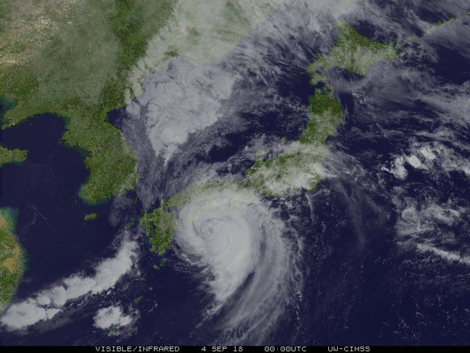
Jebi sweeping through Japan as a life-threatening typhoon


Typhoon Jebi will continue to threaten lives and property as it sweeps through Japan into Wednesday.
Jebi made landfall in eastern Shikoku around midday Tuesday, local time, with the equivalent strength to that of a Category 3 hurricane. The storm then crossed through southern and central Honshu. 

Nearly one million people were put under evacuation advisories as the typhoon approached, according to Reuters.
https://www.accuweather.com/en/weather-news/typhoon-jebi-to-deal-japan-another-dangerous-blow/70005948

Metro Detroit weather forecast: Heat advisory begins today, goes into tomorrow

DETROIT - Low clouds are leaking a little spit and drizzle early around Metro Detroit keeping some of our roads a little damp.

The bigger weather story once again today is the heat! We have a Heat Advisory Tuesday and Wednesday in the heart of SE Lower Michigan because of temperatures reaching well above average near 90 degrees with high dew points and humidity. Several days of this now can take a toll on your body so we are all advised to stay hydrated, find air conditioning as much as possible, and take it easy.

The heat index will be 95° to 100° today and tomorrow. We have clouds to partly cloudy skies today warming us quickly. Warming winds SSE 5-10 mph will keep the humidity pouring in and there may be a few isolated rain and thunderstorms with the peak heat of the day between 2 p.m. and 7 p.m.

https://www.clickondetroit.com/weather/metro-detroit-weather-forecast-heat-advisory-begins-today-goes-into-tomorrow

Helene and Possibly Isaac Could Form This Week on the Heels of Florence and Gordon

Right on cue with the September peak of hurricane season, the Atlantic Basin has come to life with Florence and Gordon, and two more storms could soon develop off the African coast.

In the far eastern Atlantic Ocean near the Cabo Verde Islands, the National Hurricane Center is monitoring a broad area of low pressure, dubbed Invest 92L, with disorganized shower and thunderstorm activity. This is a naming convention used to identify features that could develop into a tropical depression or storm.

The NHC has given Invest 92L a high chance of development into a tropical depression by the end of the week. If this system strengthened into a tropical storm, it would be given the name Helene.

Invest 92L isn't the only system we might have our eyes on in the Atlantic this weekend.

Forecast model guidance is depicting another tropical disturbance that will roll off the African coast by late-week. That system is also being watched for tropical development.

The NHC has given the next system a low chance of development through the weekend. The next named storm after Helene would be Isaac.

Even if both of these systems form, it's too early to determine whether either of these would affect any land areas down the road.

https://weather.com/safety/hurricane/news/2018-09-04-tropical-atlantic-helene-possibly-isaac-formation

Gordon Should Have Retired 24 Years Ago

According to an article on The Weather Channel, the name Gordon, should not be used for the upcoming tropical storm that is set to hit the Gulf Coast this week. The World Meteorological Organization which is responsible for naming storms, repeats its list about every six years. The only time that a name on the list is retired and not used for any future storms is when a storm with a given name ends up being extremely catastrophic. According to the article, in 1994 there was also a tropical storm that was given the name Gordon. That storm in particular hit Haiti and caused terrible flooding which resulted in the death of over 1,000 people.

The only reason why Gordon was not retired from the list of names for storms was because none of the countries that were affected by the extreme weather submitted a formal request to have the name permanently retired. There have been other storms in recent years that should have not received certain names. The article also mentions Alberto, which also resulted in terrible flooding and the death of 30 people has also been reused in recent years. It would be interesting to see how often this continues to occur as time goes on.

https://weather.com/safety/hurricane/news/2018-09-04-tropical-storm-gordon-name-retired-haiti-1994


How hot weather – and climate change – affect airline flights

National and global transportation systems and the economic activity they support have been optimized for the climate in which it all developed: Machines are designed to operate in common temperature ranges, logistical plans depend on historical weather patterns and coastal land development is based on known flood zones. In the aviation sector, airports and aircraft are designed for the weather conditions experienced historically. Because the climate is changing, even fundamental infrastructure elements like airports and key economic sectors like air transportation may need to be redesigned and reengineered.

 Global temperatures have been steadily rising for decades, and they will almost certainly continue to do so. In some regions, there is evidence that the hottest temperatures may increase at a faster rate than the average, further stacking the deck in favor of extreme heat. These hotter temperatures will reduce air density and make it much more likely weight restrictions are needed for flights taking off during the hottest parts of the day.


Many sectors of the economy, including the aviation industry, have yet to seriously consider the effects of climate change. The sooner, the better: Both airport construction and aircraft design take decades, and have lasting effects. Today’s newest planes may well be flying in 40 or 50 years, and their replacements are being designed now. The earlier climate impacts are understood and appreciated, the more effective and less costly adaptations can be. Those adaptations may even include innovative ways to dramatically reduce climate-altering emissions across the aviation sector, which would help reduce the problem while also responding to it.

https://theconversation.com/how-hot-weather-and-climate-change-affect-airline-flights-80795
More Flooding Rain Through Tuesday in Flood-Weary Parts of New York, Pennsylvania and New England

An area of heavy rain developed Monday morning, triggering significant flooding in parts of eastern Pennsylvania, New Jersey and northern Delaware.
Numerous water rescues, evacuations and road closures were reported in the region. A few homes and businesses were reported flooded in Ocean County, New Jersey, where 7 to 8 inches of rain was measured.
Heavy rain in northeastern Pennsylvania prompted the National Weather Service to issue a flash flood emergency for western Bradford County, Pennsylvania, through Monday evening because up to 4 inches of rain had fallen and "major life-threatening flash flooding was ongoing."

Unusual summer windstorm to create dangerous waves, possible flooding around Great Lakes

An unusually potent storm for late August will cause gusty winds and rough waters around the Great Lakes region through the middle of the week.
The same storm responsible for severe weather and flooding to start the week over the Midwest has departed the Upper Midwest.
However, gusty winds more typical of storms during October and November will stir the waters on the Great Lakes in its wake.
Winds averaging 15-30 mph with gusts to 40 mph are forecast.Great Lakes 8.22 AM