https://weather.com/storms/tornado/news/2018-12-04-us-tornado-deaths-on-pace-to-finish-with-fewest-since-1875
Showing posts with label Kendal Freeze. Show all posts
Showing posts with label Kendal Freeze. Show all posts
Wednesday, December 5, 2018
Illinois Severe Weather Causes 10th Death by Tornado This Year
A person was killed by a tornado in Missouri last week, bring the count of death by tornado to ten people this year. Since the start of the year, nine tornadoes have been responsible for the ten deaths, but this number is low compared to death tolls in other years. Although it is too soon to predict if the numbers will change, 2018 has the least amount of deaths by tornado since 1875. In previous years, the fewest number of deaths was 12, and that was in the year 1912. The average of people killed by tornadoes per year is 69, so this years total comes in way below that number. One reason why this number may be lower than usual is that the jet stream pattern was not favorable to tornado formations in the spring, when most tornadoes occur.

Saturday, December 1, 2018
12 Tornadoes Reportedly Touch Down in Central Illinois
Approximately a dozen reports of tornadoes were made on Saturday, December 1st in central Illinois. Surveys are scheduled to be conducted on Sunday, December 2nd. Five different counties had reports of tornadoes, according to article in the Chicago Tribune. No injuries or deaths have been reported, however. The tornado watch for central Illinois expired at 7pm on Saturday, and storms are expected to lose strength as they move toward Chicago. Some thunderstorms are expected to happen near the city, but mostly light rain will occur.
https://www.chicagotribune.com/news/local/breaking/ct-met-tornado-20181201-story.html
https://www.chicagotribune.com/news/local/breaking/ct-met-tornado-20181201-story.html
Thursday, November 29, 2018
Airplanes Cause Snow to Develop Near Chicago
Tuesdays burst of heavy snow was likely caused by airplanes making landing in Chicago. According to an article on weather.com, flight tracking on Tuesday showed evidence of flights making a loop for landing over Lake Michigan in approximately the same spot where doppler radar picked up a pocket of snow and precipitation. In a process called inadvertent cloud seeding, planes descended for landing through water-laden clouds in temperatures below freezing. The airplanes caused the formation of ice and ice crystals to happen as they passed through altocumulus clouds. These formations are rare.
https://weather.com/news/news/2018-11-28-chicago-lake-michigan-airplanes-snow
https://weather.com/news/news/2018-11-28-chicago-lake-michigan-airplanes-snow
Severe Storms Expected in Southern US
Severe weather is expected to happen in southern United States. According to accuweather.com, a warm air surge will emerge out of the Golf of Mexico during the end of this week. This warm air will mix with the incoming store system and create conditions for severe weather in states like Texas, Louisiana, Tennessee, Arkansas, Missouri, and southern Illinois. Temperatures are expected to rise dramatically, for example, Little Rock will have a low of 25 degrees on Tuesday night, but reach a high in the 70s the next day. The peak of the severe weather is expected to occur on Friday night, with high wind speeds and low visibility. Tornadoes are also a possibility, and will likely have a greater chance at forming during the evening.

https://www.accuweather.com/en/weather-news/southern-us-warmup-to-fuel-severe-weather-event-through-friday-night/70006755
https://www.accuweather.com/en/weather-news/southern-us-warmup-to-fuel-severe-weather-event-through-friday-night/70006755
Tuesday, November 13, 2018
Death toll of California Wildfire jumps to 42
The current California wildfire that is being nicknamed the "Camp Fire" has already claimed 42 lives, according to reports. This would make it the deadliest wildfire in California history. Although official numbers report 42 people dead, there are still reports of 228 individuals that are missing. It has also been reported that 7,600 homes have been destroyed, also a record high.
The fire ranges approximately 175 miles north of San Francisco, and has expanded about 125,000 acres. Only 30 percent of the fire is considered to be contained, and more than 52,000 people are under evacuation orders.
A separate fire that's being named the "Woolsey Fire" is burning in Southern California, near the Malibu coast. This fire has 200,000 people under evacuation orders, has killed at least two people, and has ruined 435 structures. The Woolsey fire is currently 35 percent contained.
Other states have sent in fire crews to help with efforts to stopping the fire. These states include Oregon, Texas, Georgia, and Missouri. There are currently 9,000 fire fighters trying to contain these fires. California has experienced two of the worst wildfire seasons in the past few years, many experts are saying this is due to the droughts in Western United States.
https://www.cnbc.com/2018/11/13/death-toll-jumps-to-42-in-californias-deadliest-wildfire-ever.html
The fire ranges approximately 175 miles north of San Francisco, and has expanded about 125,000 acres. Only 30 percent of the fire is considered to be contained, and more than 52,000 people are under evacuation orders.
A separate fire that's being named the "Woolsey Fire" is burning in Southern California, near the Malibu coast. This fire has 200,000 people under evacuation orders, has killed at least two people, and has ruined 435 structures. The Woolsey fire is currently 35 percent contained.
Other states have sent in fire crews to help with efforts to stopping the fire. These states include Oregon, Texas, Georgia, and Missouri. There are currently 9,000 fire fighters trying to contain these fires. California has experienced two of the worst wildfire seasons in the past few years, many experts are saying this is due to the droughts in Western United States.
https://www.cnbc.com/2018/11/13/death-toll-jumps-to-42-in-californias-deadliest-wildfire-ever.html
First measurable snowfall in Chicagoland area
Last Friday, the Chicagoland area experienced it's first measurable snowfall of the season. By 9am on Friday, some areas had already seen up to two inches of snowfall. While the suburbs experienced visible snowfall, closer into the city snowfall was not as visible. Flurries occurred, but O'Hare and Midway only received about .1-.3 inches of snow, while the Loop received almost none at all. The snow did cause slick road conditions, however. There was a reported crash on Route 41 that caused a Fedex truck to roll over.
https://abc7chicago.com/weather/chicago-weather-area-sees-first-measurable-snowfall-of-season-/4652886/
https://abc7chicago.com/weather/chicago-weather-area-sees-first-measurable-snowfall-of-season-/4652886/
Wednesday, October 24, 2018
Hurricane Willa Makes Rainfall
Hurricane Willa made landfall in Mexico late Tuesday evening. The estimated maximum winds during landfall were around 120mph, with pressure at 965 millibars. For a brief period earlier in the week, Willa was classified as a category 5 hurricane, but it weakened due to the eyewall replacement cycle and increasing wind shear. By the time the storm hit land it was reduced to a category 3, and lost a lot of strength as soon as it made its initial landfall. The damage has yet to have been estimated, but the moisture from the storm is expected to enhance rainfall in Texas and along the Gulf Coast.
https://weather.com/storms/hurricane/news/2018-10-22-hurricane-willa-pacific-ocean-mexico-landfall
https://weather.com/storms/hurricane/news/2018-10-22-hurricane-willa-pacific-ocean-mexico-landfall
Super Typhoon Yutu hits U.S. Territories
According to an article on weather.com, a category 5 super typhoon is currently hitting U.S. territories. The two islands affected are Saipan and Tinian, which are in the U.S. Commonwealth islands of the Northern Mariana Islands, about 120 miles northeast of Guam. The storm has been classified as a category 5 typhoon, with wind speeds up to 180mph. The National Weather Service doppler had a clear view of the tycoons eyewall until the service was knocked out, presumably from the intensity of the storm. There had been clear signs that there was lightening strikes within the eyewall, which usually means the the storm is intensifying even more. The typhoon hit the islands late Wednesday an is expected to continue to continue to cause damage until Thursday afternoon. The storm surge is projected to reach anywhere from 15-20 feet. This is the strongest typhoon on record to hit these islands.
https://weather.com/storms/typhoon/news/2018-10-24-super-typhoon-yutu-mariana-islands-guam-western-pacific
https://weather.com/storms/typhoon/news/2018-10-24-super-typhoon-yutu-mariana-islands-guam-western-pacific
NOAA Makes Changes to its Weather Model
According to an article on arstechnica.com, NOAA (National Oceanic and Atmospheric Administration) is making big changes to its global weather model. Recently, NOAA just appointed Brian Gross the new director of the Environmental Modeling Center, which deals with the forecasting models of the agency. The primary model used is the Global Forecasting System, which provides 7-10 day forecasts. The new model will implement an F3 core, which is a more computationally efficient model that allows the supercomputers to process the models more quickly, provide more rapid results, and allow the model to run at a higher resolution. The F3 model has been running in the background at the NOAA for the past year and it overall performs a bit better than the GFS model. There have been some problems with the F3 model, like its accuracy with predicting hurricane tracks and the amount of precipitation hurricanes have the potential of producing. Regardless, the change is very exciting and is projected to be better at predicting weather.
https://arstechnica.com/science/2018/10/noaa-is-about-to-make-some-big-changes-to-its-global-weather-model/
https://arstechnica.com/science/2018/10/noaa-is-about-to-make-some-big-changes-to-its-global-weather-model/
Tuesday, October 16, 2018
Iceberg 5 Times the Size of Manhattan About to Break from Antartica
According to an article written on The Weather Channels website, scientists have recently discovered a large rift on the Pine Island Glacier that could cause a major ice breakaway. The rift currently extends 19 miles, but if it continues another six miles it could cause more icebergs to break away. If it were all to break off in one piece, it would be approximately 115 square miles. It is very common for calving to occur, but scientists are concerned with the frequency at which Pine Island is experiencing break aways. If this piece of ice were to break away, it would be the sixth largest to occur since 2001.

https://weather.com/science/environment/news/2018-10-15-pine-island-glacier-iceberg-rift
https://weather.com/science/environment/news/2018-10-15-pine-island-glacier-iceberg-rift
Texas Experiences Terrible Flooding
South-central Texas experiences major flooding last night that has already caused one death. It has been reported that approximately 10 inches of rain fell, causing the Llano River to flood and cause dramatic flooding. All residents within a quarter mile of the river were urged to evacuate, as flood waters caused bridges to collapse and homes to flood. Reports say that there have already been eight emergency rescues in the areas affected.
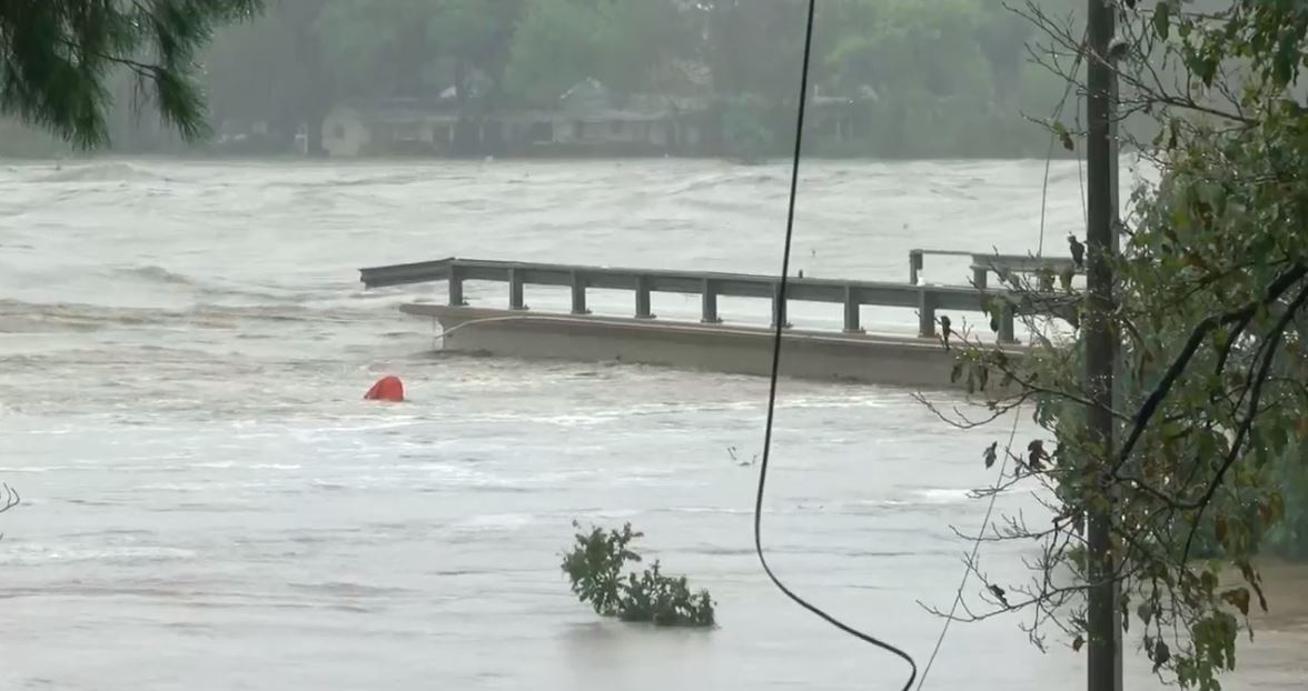
https://weather.com/news/news/2018-10-16-texas-flooding-evacuations
Monday, October 15, 2018
Weather Extremes Could Cause Decrease in Beer Supply
A new study from University of East Angila is reporting that severe drought and heat could cause barley supplies to decrease, meaning that beer consumption would also decrease and the price of beer would go up. According to the article, in recent years the worlds beer sector has consumed approximately 17% of the worlds supply of barely. Beer is also the most popular alcoholic beverage consumed in the world. The study predicts that in the worst-case scenario, the worlds consumption of beer will decrease by 16%. In less extreme circumstances, consumption will still decrease by 4%, but price of beer will increase by 15%. European countries like Belgium and Germany may see the biggest decrease in supply, anywhere from 27-38%.
https://phys.org/news/2018-10-beer-threatened-future-weather-extremes.html
https://phys.org/news/2018-10-beer-threatened-future-weather-extremes.html
South-Western France Damaged By Flooding
France has been dealing with horrible flooding after officials say that month's worth of rain fell within hours overnight this week. The rain caused the River Aude to flood tremendously, and had already killed ten people. Some residents are angry about the lack of warning given about the large amounts of rainfall and the flooding. The flooding has caused seven helicopters and 700 emergency response personnel to be deployed. Reports say that in some areas, flood waters reached twenty-three feet. Many schools and tourist attractions have been closed until the waters lower.
https://www.bbc.com/news/world-europe-45861428
https://www.bbc.com/news/world-europe-45861428
Death Toll Rises to 18 After Hurricane Michael
The death toll due to Hurricane Michael is now 18. Searches are still underway as at least 46 people have not been accounted for. The storm. which hit the golf coast last week, resulted in major damage for many cities which officials are saying may take years to rebuild. Many people chose not to evacuate, despite the many warnings given by officials that the storm would be powerful and deadly. The poor were majorly affected by the storm, and many did not have the choice to evacuate since they did not have working vehicles to escape from the storm. Along with many buildings being damaged, including schools and prisons, agriculture was also damaged in Georgia. Hurricane Michael will have lasting effects on cities effected.
https://weather.com/storms/hurricane/news/2018-10-15-hurricane-michael-latest-impacts-florida-georgia
https://weather.com/storms/hurricane/news/2018-10-15-hurricane-michael-latest-impacts-florida-georgia
Wednesday, October 10, 2018
Hurricane Michael Hits Golf Shore
Hurricane Michael made landfall today on the panhandle of Florida and has proven to be a strong and dangerous storm. Hurricane Michael is currently categorized as a category 4, and more than 350,000 people along the golf coast have been urged to evacuate. By 3pm today, it was already reported that approximately 250,000 homes were without power. President Trump has issued a state of emergency for Florida in order to provide as many resources as possible to the areas affected. Many Universities have closed until the hurricane passes.
https://weather.com/storms/hurricane/news/2018-10-10-hurricane-michael-impacts-florida-gulf-coast
https://weather.com/storms/hurricane/news/2018-10-10-hurricane-michael-impacts-florida-gulf-coast
Wednesday, September 26, 2018
Weather and AI For Brands
According to an article on adage.com, Brands are starting to use artificial intelligence regarding weather to better predict which ads will do better and certain times of the year. According to the article,"Fluctuations in weather can determine the frequency and timing of everything from doctors visits to shopping trips to attendance at entertainment and sporting events" (Kinzler). Recently IBM Watson Advertising merged its WEATHERfx platform with Truven MarketScan database to create WEATHERfx Health. This database helps predict which certain weather patterns are associated with different health conditions. For example, those with frequent migraines may be more prone to getting one in dry or humid climates. With information like this, retailers and manufacturers can better determine when their ads will be more effective. A cough drop brand recently used the database to do just that and as a result their ads were more effective in generated revenue. It is very interesting to see how weather databases are beneficial to the market and how this will affect marketing in the future.
https://adage.com/article/ibm-watson-advertising/ai-unlocking-a-sixth-sense-brands/311552/
https://adage.com/article/ibm-watson-advertising/ai-unlocking-a-sixth-sense-brands/311552/
NASA Shrinks Satellites
According to an article on cnet.com, NASA is testing smaller satellites to get a better look inside storms. Recently, NASA has tested a satellite about the size of a shoebox and have been receiving promising results. NASA's department Jet Propulsion Laboratory is testing RainCube to see if the smaller satellites can produce more information in a shorter amount of time. These satellites would be more cost-effective than those being currently used. These smaller satellites would fly together (the article gives the examples of a flock of geese) and track real time information on things like rain, hail, snow, and sleet. The RainCube only weighs 26 pounds, and signals from its antenna bounces off raindrops and sends back information. NASA, although excited about this new device, does mention that these will not provide a global view of storms but is definitely better at understanding specific storms.

The RainCube
https://www.cnet.com/news/nasa-shrinks-weather-satellites-way-down-to-better-see-inside-storms/
The RainCube
https://www.cnet.com/news/nasa-shrinks-weather-satellites-way-down-to-better-see-inside-storms/
Tuesday, September 25, 2018
Six Tornadoes Hit Ottawa
This past weekend Ottawa, Canada, was hit with multiple tornadoes as the result of extreme weather. According to an article on ctvnews.ca, six tornadoes touched down and caused severe damage and power outages throughout the area. The strongest tornado was an EF-3, which tore through a rural part of Ottawa, and the others have been classified as EF-2's and EF-1's. Combined, these tornadoes damaged around fifty homes and around 200 buildings. The storms left 3500 people without power for a period of time, though most of it has been restored by now. As of today, most of the areas affected are now back to business, with schools and federal buildings reopening. Those that are still without power should have it restored by Thursday morning. It will be interesting to see how much money the damages will cost and if any more severe weather happens to those regions in the coming weeks.
https://www.ctvnews.ca/canada/environment-canada-6-tornadoes-hit-ottawa-area-last-friday-1.4108217
https://www.ctvnews.ca/canada/environment-canada-6-tornadoes-hit-ottawa-area-last-friday-1.4108217
Hurricane Season and Farmworkers
A article recently posted on The Atlantic details how hurricane season tends to be extra devastating for farmers in areas affected by hurricanes. Farmworkers livelihood depend on crops to pick and because of their legal status, they are often fearful about contacting the government when their crops are ruined in the storm. According to the article, in North Carolina 75 percent of cash crops are grown in the eastern part of the state which tends to be the most affected areas when it comes to hurricane flooding. Farmworkers, whose employment is already uncertain because most of them are migrant workers, have especially hard times during hurricane season since the storms often damage large amounts of crops. This leaves workers without jobs and without an income to support their families. The article also details how most farmworkers are pulled a week before the storm hits, further depleting their income.
The situation gets worse for farmworkers living in "campos", which are shoddily built trailers in labor camps near the farms. Most of these trailers were completely destroyed, and many of the workers living in these conditions were made to work during the storm. I think that this article was very interesting since it shows another side of how severe weather can cause distress among people in the community it affects.
https://www.theatlantic.com/family/archive/2018/09/hurricane-seasons-new-normal/571159/
The situation gets worse for farmworkers living in "campos", which are shoddily built trailers in labor camps near the farms. Most of these trailers were completely destroyed, and many of the workers living in these conditions were made to work during the storm. I think that this article was very interesting since it shows another side of how severe weather can cause distress among people in the community it affects.
https://www.theatlantic.com/family/archive/2018/09/hurricane-seasons-new-normal/571159/
Monday, September 24, 2018
Typhoon Becomes Threat to Taiwan
According to an article on weather.com, a category five typhoon names Trami could potentially hit parts of Taiwan and Japans Ryukyu Islands. Over the weekend, the typhoon went under massive intensification, starting with winds around 35 mph, gaining winds up to 65 mph, which put it in a category 4 intensity. Because of warm waters low wind shear, the typhoon is expected to intensify even more within the next few days, ultimately turning it into a category 5 storm before it hits land later this week. The path of the storm is still hard to determine at this point since it could take many directions, but at the moment, the areas that should be closely watched include Taiwan, China, and Japan. Typhoons often cause a lot of flooding, damaging winds, and sometimes landslides. Asia has been getting hit with many typhoons recently, including one in the Philippines last week and another one in Japan earlier this month. It will be interesting to see how this storm develops over the week and what damage it causes.
https://weather.com/storms/typhoon/news/2018-09-23-typhoon-trami-forecast-taiwan-japan
https://weather.com/storms/typhoon/news/2018-09-23-typhoon-trami-forecast-taiwan-japan
Subscribe to:
Posts (Atom)