Thursday, October 3, 2019

Vast iceberg bigger than Los Angeles breaks off Antarctic shelf

A enormous iceberg bigger than Los Angeles or Greater London has separated from the Amery Ice Shelf in Antarctica, the largest to do so in more than half a century.
The table iceberg, named D-28 by scientists, broke off the shelf in east Antarctica on September 26. It measures 1,636 square kilometres (632 square miles) in area, is 210 meters (689 feet) thick and weighs a massive 315 billion tons.
The iceberg will now be tracked because it poses a potential hazard for shipping. Scientists from the Australian Antarctic Program, Institute for Marine and Antarctic Studies and the Scripps Institution of Oceanography, San Diego have watched developments on the ice shelf for almost 20 years, after first spotting a rift developing in the early 2000s.
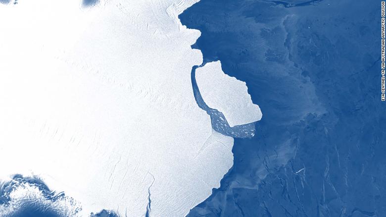
The D-28 iceberg calving off the front of the Amery Ice Shelf.


The Surpassing of October Temperature Records in Eastern U.S. Cities

On Tuesday alone, over 30 cities set new all-time high temperatures for the month of October.


"A roller coaster-like jet stream pattern across the country is to blame for the summer-like heat across a wide swath of the eastern United States," AccuWeather Meteorologist Brandon Buckingham said.

For a time on Wednesday afternoon, every weather station across eight different states were reporting temperatures higher than that of Death Valley National Park in California, one of the hottest places on Earth.


Tuesday, October 1, 2019

Hail, Tornado, and Low Temps Hit California

A series of unusual weather events hit the city of Davis, California, on September 28 and 29, 

2019. Thunderstorms swept through the state's central part, producing dime-sized hail. A 

tornado was also spotted near the area. The tornado touched down on September 29 to the east. 

Meanwhile, gustnadoes were reported as well on the same day, near HWY 80 Westbound near 

Davis. According to Robert Shackelford, CNN Weather producer, the tornado was weaker 

then those of typical Midwestern. "California sees about 10 tornadoes a year, so this is rather rare 

for the area," he said. They are more likely to see tornadoes in the winter and spring, but it isn't 

uncommon to see tornadoes in the fall. Heavy hailstorms were reported in the area prior to the 

tornado. On Sunday morning, September 29, a record low temperature of 45 °F was 

experienced in nearby Sacramento, breaking the previous record of 46 °F in 1986.


Hail, tornado, and record-low temperatures hit California, USA

September Snowstorms hits Montana

A record-smashing snowstorm with wet snow and strong winds hit parts of the Northern Rockies on September 28 and 29, 2019, resulting in power outages, uprooted trees, and road closures. Several parts of Montana experienced blizzard conditions and more than a foot of snow, setting new daily rainfall records. Wind gusts from 40 to 60 mph were measured in Montana.
AccuWeather Senior Meteorologist Alex Sosnowski explained the cause behind the historic snowfall, saying "the combination of a storm from the Pacific Ocean, a fresh injection of cold air from northern Canada, moisture from the Gulf of Mexico and a northeast-ascending flow that squeezed extra moisture from the atmosphere produced the amazing snowfall."
The highest snowfall was recorded in Browning, Montana with a total of 4 feet. Meanwhile, East Glacier Park received 2 feet of snow.
It beat the daily record of 6.1 inches set in 1954. With a total of 19.3 inches, the two-day record came second to that of April 27 to 28 in 2009, with 24.2 inches, which was the city's heaviest snowfall in two days.
It usually takes until a week before Christmas for the area to have a total of 19.3 inches of snowfall in an average winter.
Blizzard conditions were experienced across the northern and southern Rocky Mountain front, including at the Cut Bank, Montana, Airport where there was moderate to heavy snowfall with sustained winds of 30 mph on September 29.

Record-breaking September snowstorm dumps 4 feet of snow on parts of Montana, USA

Tropical Storm Nardan Kills Two

What was once Tropical Storm Narda dissipated on Tuesday morning but not before killing two people while raking along Mexico’s Pacific coast.
The two deaths occurred in the southern state of Oaxaca on Sunday, according to the Associated Press. A 26-year-old man died while trying to cross a river in San Pedro Mixtepec, and a 17-year-old boy was swept away in a river at San Jeronimo.
Also in Oaxaca, where Narda made landfall Saturday, thousands were evacuated. Thirteen municipalities suffered serious damage, according to Mexico News Daily.
Narda's rainfall also caused a landslide that buried a butcher shop and a clothing store in the Oaxacan town of Santa Catarina Juquila, Mexico News Daily also said. No injuries were reported in the landslide.
Floodwaters dragged three vehicles off the roads in Acapulco, and flooding damaged a public hospital.
A number of people had to be rescued after getting caught in fast-flowing rivers, Televisa reported.


This is what politicians debating global warming will look like soon


Aurora Borealis Forecast for Tuesday, October 1, 2019

https://cdn.softservenews.com/Aurora.htm

By JIM THOMAS -- Soft Serve News
Auroras are difficult to predict with precision. They have stops and starts (known as sub-storms). If you are out there, you need to be patient and lucky. Here are some tools that will increase your chances. 


The New Soft Serve News Aurora Prediction Program estimates that . . .


in 4 minutes, the Geomagnetic Activity level (Kp number) will be 0.67 -- Quiet
in 8 minutes, the Geomagnetic Activity level (Kp number) will be 1 -- Quiet
in 12 minutes, the Geomagnetic Activity level (Kp number) will be 0.67 -- Quiet
in 17 minutes, the Geomagnetic Activity level (Kp number) will be 1 -- Quiet

Why miss your Aurora?  
Get Aurora Alerts customized for your location.

Now, find the Kp number line on one of the following maps that matches the Kp number predicted above. If you are located at or above the estimated Kp line, you are in the right spot. You might even be in luck if you are located within next lower line, but you will have to look lower on the horizon. Be aware though, ground based light pollution and weather will have a greater impact at these more marginal locations.