At a Glance
- Severe thunderstorms are likely into Tuesday morning over parts of the South.
- Damaging thunderstorm winds and tornadoes are the main threats.
- More severe thunderstorms are expected in a swath of the East Tuesday.
Severe thunderstorms packing a threat of damaging winds and tornadoes are likely into Tuesday morning over a swath of the South. This threat of severe weather will then spread into the East.
(MORE: Tornado Central)
NOAA's Storm Prediction Center has issued the following severe weather watches:
- A tornado watch valid until 3 a.m. CST for southeastern Arkansas, northern Mississippi and western and middle Tennessee. This watch area includes Nashville, Memphis, Tennessee, and Tupelo, Mississippi.
- A tornado watch valid until 6 a.m. CST for northern Alabama, a section of middle and eastern Tennessee, and south-central Kentucky. This watch includes Huntsville, Alabama; Chattanooga, Tennessee; and Campbellsville, Kentucky.
Current Radar, Watches and Warnings
(Watches and warnings are issued by the National Weather Service.)
Damaging thunderstorm wind gusts and tornadoes are the main threats. Locally heavy rainfall is also likely.
Please have at least two ways of receiving severe weather alerts – NOAA weather radio, EAS cell phone alerts, mobile app or push alerts – that will wake you up if severe weather threatens you overnight.
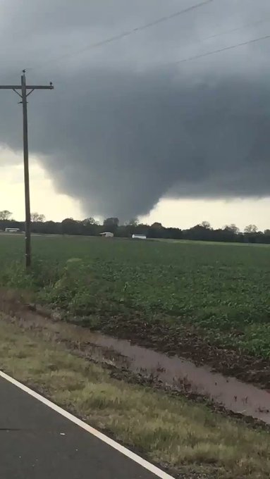
At least one tornado was spotted Monday evening in Natchitoches Parish, Louisiana, where damage was reported near Natchez and Natchitoches.
Additional damage was reported in Marthaville, Louisiana, where a home was severely damaged by a possible tornado.
(LATEST NEWS: Tornadoes, Damage Reported in the South)
Timing the Storms
Into Tuesday morning, severe storms in the form of a squall line will sweep eastward through central and eastern Kentucky, middle and eastern Tennessee, northern and central Mississippi, northern Alabama and northwestern Georgia. Some damaging thunderstorm winds are possible as far north as Ohio.
Tuesday
- Forecast: Severe storms could be ongoing Tuesday morning in western portions of the red area depicted on the map below. Strong to severe storms could then spread to parts of the mid-Atlantic and Southeast coast through the day while gradually weakening over time.
Storms may reintensify on Tuesday afternoon and evening from eastern Virginia across the Delmarva region, perhaps including the Washington and Baltimore areas.
- Threats: Damaging winds and a few tornadoes are possible, as well as locally heavy rainfall.
(MORE: Election Day Forecast)
Tuesday's Severe Thunderstorm Forecast
(Shaded on the map above is the likelihood of severe thunderstorms. Note that not all categories apply for the severe weather risk on a particular day.)
Many of the areas that could experience another round of severe weather just saw dangerous storms that spawned at least 45 confirmed tornadoes in six states.
Second Severe Weather Season
Although the threat of tornadoes is generally highest in the spring, fall is considered the second severe weather season.
The highest threat of tornadoes in November is from eastern Texas into Alabama, which is included in the area to watch this week.
This is due to southward dips in the jet stream and cold fronts that track across the South and Midwest, where warmer temperatures and higher dew points are more likely to be found in November compared to areas farther north.
The average number of tornadoes in the U.S. in November from 1991-2015 is 56.
(USTornadoes.com)
Just two years ago, November had more than 35 tornadoes from Louisiana to the Carolinas. Three of these tornadoes were rated EF3, and there were five deaths.
Another recent November tornado outbreak occurred on Nov. 17, 2013, when over 70 tornadoestore across seven states. More than 50 of those tornadoes were in Illinois and Indiana. Two tornadoes from this outbreak were rated EF4, and three were rated EF3.
In late-November 1992, there was a tornado outbreak with more than 90 tornadoes across the South that killed 26.
https://weather.com/storms/severe/news/2018-11-02-severe-thunderstorms-tornado-wind-hail-south-lower-mississippi-valley
posted by Ciela Marie Acala


No comments:
Post a Comment