Showing posts with label Nelson Rivera. Show all posts

Saturday, December 6, 2014

Great Falls second most unpredictable weather city

Great Falls was named the second most unpredictable city in the nation — weatherwise at least.
After comparing three years of data from across the United States, FiveThirtyEight.com awarded the Electric City the silver, behind Rapid City, S.D.
Authors Nate Silver and Reuben Fischer-Baum gathered data from 120 National Weather Service forecast offices to compare daily weather to long-term averages. They also considered weather statistics relating to temperature, precipitation and severe weather.
The article found that most unpredictable weather happened in cities that were landlocked.
Robert Hoeisch, a meteorologist with the Great Falls National Weather Service, said water moderates temperatures because it doesn’t change temperature as easily as air. He added that Great Falls’ unpredictabality also relied on the systems brought by Arctic air.
Hoeisch cited last year’s drastic temperature changes as an example. Dec. 7, recorded 33 degrees below zero. On Dec. 27, it was 58 degrees.
“A lot of places don’t even have that range in their lowest and highest temperatures of the year,” he said.
During its calculation, FiveThirtyEight found Great Falls had the nation’s least predictable temperature.
While Hoeisch thinks the short-term temperature changes made Great Falls stand out the most, he agrees that the city deserves its second-place title.
“We’ve had over 6 inches of snow in Great Falls in August — that’s a tough one to beat in a lot of places,” he said.

California Rainfall: Sinkholes, Mudslides Reported; Flooding Hits San Diego Area

The drought-parched state of California definitely needed a soaking rain event, but all this precipitation has also had negative consequences.
Mudslides, rockslides and sinkholes have all been reported following days of rainfall across the state, leaving some streets flooded and residents in wildfire-scarred areas reaching for sandbags. While much of the event is ending, some areas are still expected to see more rain before the system leaves California.
The San Diego area was struggling with lingering rainfall Thursday morning, where some residents woke up to find flooded streets, partially-submerged cars and even reports of a mudslide or two. San Diego 6 was reporting a 60- to 80-foot-wide mudslide had occurred near the Sycuan reservation, east of San Diego, according to reporter Heather Myers.
Linda Lam, weather.com meteorologist, said the persisting rain showers should be out of San Diego by mid-morning Thursday.
Rain caused problems along the Pacific Coast Highway as early as Sunday, where rockslides were reported, but the Bay Area began seeing the heaviest precipitation on Tuesday. Street flooding was reported Tuesday morning in Mill Valley as vehicles tried to drive through the floodwaters.
Nearly six inches of rain had fallen in parts of Monterey County by midday Wednesday.

Typhoon Hagupit Makes Landfall in Philippines, Impacting Areas Vulnerable After Haiyan

A very dangerous situation is unfolding in the Philippines as Typhoon Hagupit, locally known as Ruby, makes landfall in the province of Eastern Samar. More than 30 million people will be impacted by this cyclone.
Hagupit rapidly strengthened into a super typhoon on Wednesday afternoon and into Thursday with sustained winds over 241 kph (150 mph), the equivalent to a Category 4 hurricane in the Atlantic or Eastern Pacific Ocean.
It weakened on Thursday evening and into early Friday after going through some strong wind shear. Hagupit briefly restrengthened back to a super typhoon on Friday evening before losing super typhoon status again early on Saturday morning.
AccuWeather.com Meteorologist Anthony Sagliani warned "Even with the frequent intensity changes of Hagupit, it is important that those in its path realize that a deadly, destructive storm surge is still possible near and just north of where landfall occurs."
The cyclone could still bring catastrophic damage, especially near land-falling areas. Sagliani mentioned "the coast of Western Samar, Northern Samar, Sorsogon, Albany, Camarines Sur and Catanduanes provinces are the most susceptible."
Wind gusts over 240 kph (150 mph) are expected near landfall in eastern Visayas. Landfall is expected within 100 miles of where Super Typhoon Haiyan made landfall last year.
Hagupit will slow its forward speed as it approaches and moves through the Philippines through early next week. Due to this slow movement, areas will experience this extreme weather for a long duration, further increasing the damage and impacts of the storm.

Northeast Coastal Storm: Snow, Heavy Rain, High Winds Possible Next Week


Winter has eased off the gas pedal so far in December, in contrast to a persistently cold, snowy November in the Midwest and Northeast.
Despite that, atmospheric ingredients may combine to spawn a coastal storm bringing a potpourri of wind-driven heavy rain and wet snow to parts of the Northeast in the week ahead.

The Setup

Low pressure is expected to form along the western end of a stalled frontal boundary near or offshore the Mid-Atlantic coast later Monday into Tuesday and head north into New England.
At the same time, a cold front will sweep eastward through the Great Lakes into the interior Northeast.
The interaction and intensity of each of these features remains somewhat in question this far out, holding the key to all the important foreast details. 
"Much of this uncertainty has to do with the way in which models handle various features that are still a continent away," says winter weather expert, Tom Niziol.
Another challenge with this system, as with most Northeast coastal storms, is how much cold air will be available.
Despite the passage of a cold front through the Northeast this weekend, the path of this coastal low appears likely to dislodge the cold air (translation: air below freezing near the surface) from a significant swath of the Northeast, at least for a time.

Saturday, November 8, 2014

POLAR VORTEX RETURNS (But What Does That Really Mean?)


The term "polar vortex" became frozen in our minds last winter when it became very cold and stayed that way. Meteorologists have always known about the circumpolar vortex. It is a general area of low pressure aloft that it is typically close to the North Pole in summer but spreads out and changes shape in winter. The launch pad for the widespread use of polar vortex came when last winter's circumpolar cortex expanded southward, but one part of it stretched out much more than usual. Cold air then had a straight shot from northwestern Canada right into the Midwest and on eastward.
Now, however, it seems someone is bringing up "polar vortex" every time it gets cold. In a way, saying there is a polar vortex is as useful as saying there are cars on the highway. Cars are used to get places. They're all over the place. However, if there is an accident with fatalities or injuries and backed up traffic, it is a very serious matter. The polar vortex steers winds around the globe. Sometimes it brings very cold air to us and sometimes it causes the weather to become warm, but it would be silly to say that a warm spell is brought to us by a polar vortex even though that is a common way to get a reprieve from wintry cold!
In this video, I show the forecast layout on a different map base than usual. The map is too big to show minute details, but it should help you picture why it should turn cold in the Midwest and Northeast as we go through next week.

January in November: Arctic blast to hit USA


Whether or not it's dubbed a polar vortex, icy cold will spread across much of the central and eastern USA by next week, bringing temperatures more typical of January than November.
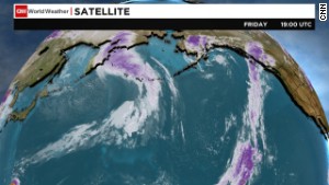
The onslaught will be fueled in part by remnants of Typhoon Nuri, which will wallop Alaska's Aleutian Islands with furious, hurricane-force winds and mammoth 50-foot waves over the weekend.
The system is expected to push cold air into much of the continental USA next week, said Bob Oravec, National Weather Service forecaster.
"In brief, when a typhoon curves away from Asia, it causes the jet stream farther to the east across the Pacific and into North America to buckle days later," said Brett Anderson, an AccuWeather meteorologist.
That contorted jet stream can lead to storms and outbreaks of cold air, as well as surges of warmth, throughout the nation.
Snow will accompany the frigid air in areas including the northern Rockies, northern Plains and upper Midwest. Milwaukee and Grand Rapids, Mich., could be the cities that see the most snow, the Weather Channel predicts.
"It looks like winter's starting early," Oravec said.
The Plains, western Great Lakes and Upper and mid-Mississippi Valleys will see high temperatures 10 to 30 degrees below average by Monday and Tuesday, the Weather Channel predicts.
Cities such as Minneapolis, Chicago and St. Louis will endure the worst cold as high temperatures reach only the 30s, said Alex Sosnowski, AccuWeather meteorologist.
Highs may struggle to top the freezing mark in the Twin Cities for several days, and strong winds will add to the wintry feel.

Flash Floods Hit Italy; Two Injured, Farmlands Destroyed


Flash flooding affected several regions in Northern Italy on Wednesday, leaving at least two injured and farmlands destroyed.
Heavy rains hit the city of Carrara in Tuscany, causing including an industrial center and neighborhood, according to the GlobalPost.
"A high-amplitude weather pattern was responsible for Italy's high-impact weather this week," weather.com meteorologist Jonathan Erdman said. 
Euronews reports that .
Around and 300 required rescue in Carrara, according to the Reactions Catastrophe Center.
Rain wasn't the only problem this week, however.
"A slow-moving, U-shaped southward plunge of the jet stream carved out over the Mediterranean Sea and North Africa. Ahead of that, moisture was pumped into southern Europe, leading to rounds of thunderstorms, and heavy snow in the Alps, as well," Erdman said. 
In Sicily, a tornado damaged several roofs, while two waterspouts formed off the northwestern coast of Italy in Liguria.
Tuscany’s agricultural association said the flooding destroyed orchards, vineyards and livestock populations.
Following the flooding, red alerts have been issued for other areas in Italy including Rome and Sicily.

Severe storm in Alaska will whip cold weather to East Coast


A strong storm over the Bering Sea -- the remnants of Super Typhoon Nuri -- will bring intense winds, massive waves and heavy rain and snow to coastal Alaska and the Aleutian Islands.
But don't ignore it just because it is a sparsely populated area with residents who are accustomed to severe weather. The powerful storm will whip the jet stream, causing a ripple effect that will carry the cold air to the East Coast.
This arctic outbreak will funnel down through Canada over the next week, bringing a deep freeze to the eastern United States, with temperatures forecast 20 degrees below average.
The ripple of frigid air starts in Alaska, where the remnants of Super Typhoon Nuri -- which earlier in the week was tied for the strongest storm typhoon of the year based on wind speed -- have strengthened, though it isn't a typhoon any longer.
Technically, it's called a mid-latitude storm.
The storm carries the energy of the typhoon and its current strength is derived from clashes of hot and cold air. This incredibly strong cyclone will alter the jet stream allowing for the cold air to plunge into the United States next week.
The effects of the cold air will be felt as early as the weekend, as temperatures will cool in the East Coast. But a second cold front with really cold air will make its way into the Upper Midwest Sunday and the East Coast by the end of next week.

Sunday, October 26, 2014

Weather Service stops receiving satellite data, issues notice about forecast quality


It appears that some satellite imagery has been restored, but that the feed of satellite data used for models remains somewhat incomplete. “The last update I received was that we are not yet fully restored, but there has been some improvement in datasets for the models,” said Chris Vaccaro, National Weather Service spokesperson. A technical notice from the National Weather Service stated the “majority” of satellite data has become available for the models.

Since at least Tuesday, some satellite data – an important input to weather prediction models – has stopped flowing into the National Weather Service due to an apparent network outage.

At 1 p.m. today, the National Weather Service’s National Center for Environmental Prediction (NCEP) issued the following statement cautioning the outage could impact forecast quality:

NCEP HAS NOT RECEIVED A FULL FEED OF SATELLITE DATA FOR INPUT INTO THE NUMERICAL MODELS SINCE 22/0000Z…POTENTIALLY IMPACTING THE MODEL FORECASTS.NESDIS AND NCEP ARE INVESTIGATING THE ROOT CAUSE OF THE ISSUE. ONCE THE SITUATION IS RESOLVED ANOTHER MESSAGE WILL FOLLOW.

http://www.washingtonpost.com/blogs/capital-weather-gang/wp/2014/10/22/weather-service-stops-receiving-satellite-data-issues-warning-about-forecast-reliability/

Heavy Rain, Strong Winds Hitting the Pacific Northwest This Weekend (FORECAST)


A heavy rain maker has set up in the Pacific Northwest, and it will continue to bring much needed rain and mountain snow through the rest of the weekend. With that said, it is also producing strong gusty wind that is downing numerous trees and powerlines. A large southward dip in the jet stream has developed over the eastern Pacific Ocean and is swinging into the West Coast this weekend. The first round of rain came ashore Tuesday night through Thursday as a low pressure system and its trailing cold front barrel into the Pacific Coast from Washington to northwest California. Less rain occurred on Friday, though a band of showers did develop from the coast of Washington through Seattle and into western Montana.
On Saturday, a second low pressure system ushered heavy rain into the Pacific Northwest. This second system brought rain as far south as San Francisco and Sacramento, as well as snow over the Cascades and northern Rockies.
A general 1 to 3 inches of rain is expected from Northern California through coastal Washington through Sunday, with up to 4 to 5 inches possible in a few spots. Thunderstorms may develop in northern California and western Oregon and a few thunderstorms may be severe, with an isolated tornado possible as well.
Strong wind will also accompany this system and wind advisories are still in effect into midday Sunday.


Saturday, October 18, 2014

Hurricane Gonzalo Moving Toward Newfoundland After Hitting Bermuda (FORECAST)


Hurricane Gonzalo is quickly moving away from Bermuda and is expected to pass near Newfoundland through the overnight hours into early Sunday morning.
Gonzalo is weakening and is now a Category 1 hurricane with 90 mph maximum sustained winds.
At 8:30 p.m. EDT Friday, Hurricane Gonzalo made landfall as a Category 2 hurricane with 110 mph winds along the south-central coast of Bermuda. Despite Bermuda being a small target (21 square miles), the center of Gonzalo's large eye still passed over the islands. This was the second time in less than a week that Bermuda had a direct hit from a tropical cyclone.
Sustained winds at the Bermuda airport reached 74 mph with gusts up to 96 mph reported. Commissioners Point, which has an elevation of 262 feet, reported a sustained winds of 101 mph and a gust to 144 mph.
Gonzalo continues to race off to the north-northeast and the tropical storm warning for Bermuda has been discontinued.
Conditions on Bermuda have improved. Meanwhile, tropical storm-force winds may reach Newfoundland, where there is a tropical storm watch in effect.

Hawaii Residents Prepare for Hurricane Ana Impacts


Hurricane Ana pushed south of Hawaii's Big Island early Saturday morning EDT, generating heavy rains and winds.
As of Saturday morning, the storm, which was upgraded from a tropical storm to a hurricane Friday, had weakened slightly, with maximum sustained winds of 80 mph. Very little change in strength is expected throughout the day Saturday.
Although the center of Hurricane Ana passed south of the Hawaiian Islands, some impacts will still be seen. The National Weather Service issued a public alert about outer rain bands moving onto the Big Island at 2 a.m. local time Saturday morning (8 a.m. EDT). 
Waves were expected to crest to 10 to 15 feet on both the North and South shores of Hawaii's islands late Saturday and to remain tall through Sunday. The National Weather Service had flood advisories in place for the Big Island until 7:30 a.m. HST (9:30 a.m. PDT) and Honolulu until 8:30 a.m. HST (10:30 a.m. PDT).
Gov. Neil Abercrombie declared a state of emergency Friday, which will allow the state to access state and federal resources.
Ana became a Category 1 hurricane earlier in the day when it was about 230 miles south of Hilo. Shortly before midnight, it had maximum sustained winds of 85 mph and was churning along its course at 13 mph.
The hurricane was expected to gradually weaken to become a tropical storm again by early Sunday morning, Chris Brenchley, a forecaster with the National Weather Service in Hawaii, told The Associated Press.
Swells were picking up on the Big Island's south shores Friday afternoon, with 15-foot waves seen in Pohoiki Bay.
But the approaching storm didn't stop some tourists in Honolulu from spending time around the beach Friday.

Friday, October 10, 2014

Genoa, Italy and Nimes, France Swamped By Flash Flooding; One Dead


Heavy rainfall sent floodwaters rushing through parts of northern Italy and southern France Thursday into Friday, swamping buildings, trapping vehicles and killing at least one.
Flooding swamped city streets in the northern Italian coastal city of Genoa (population about 600,000) Thursday night. , then floated, and piled into and on top of each other once the floodwaters subsided.
A 57-year-old man was killed in Genoa after being swept away in floodwaters, according to Reuters. Streets were left covered in mud after the water receded. A and forced the evacuation of 16 families and a few mudslides were reported on several major highways, according to Italian news site Primocanale.it. 
More than 7 inches of rain fell in Genoa in a three-day period ending Friday morning, local time. However, Thursday into early Friday, alone, 7-12 inches of rain had fallen in the Apennine Mountains north of the city, helping to push the Bisagno River well out of its banks. 

Rains cause minor flooding in Colorado Springs; snow in mountains


Wet weather socked in the Front Range on Thursday, causing some urban flooding and traffic problems in Colorado Springs and elsewhere.
Fountain Creek, south of Colorado Springs, ran over its banks Thursday afternoon, flooding into mostly agricultural areas and not causing major problems, said Larry Walrod, a senior meteorologist with the National Weather Service in Pueblo.
The Weather Service issued a flash-flood watch for the Interstate 25 corridor Thursday north of Colorado Springs and south to the New Mexico state line, including Pueblo and Trinidad.
There was minor urban flooding Thursday afternoon in Colorado Springs and water washed over some streets, including the intersection of Siferd Boulevard and Date Street, forcing temporary closures.
In cities there's "lots of asphalt and no place for the water to go when it comes down so quick," Walrod said.
Some areas in and around Colorado Springs received up to 3 inches of rain Thursday, but that was over about a four-hour period, not in a torrential downpour.

Thursday, October 2, 2014

Severe Weather Slams Dallas, Millions Under Threat


A line of powerful thunderstorms rumbled across Dallas on Thursday, knocking out power for thousands and grounding flights — part of a system that stretched to the Great Lakes and threatened 40 million with flash floods, hail and perhaps even tornadoes.
Emergency management officials, already busy with the city’s response to the first U.S. diagnosis of Ebola, had to shift their attention. “Short break from Ebola Response to Severe Weather management,” Dallas emergency officials said on Twitter.
Gusts as strong as 70 mph, almost the force of a tropical storm, were recorded as the storms tore through Dallas in the late afternoon, The Weather Channel reported. Police reported one minor injury after the roof was blown off a building at Arlington Baptist College, and a teacher in Denison was taken to the hospital after lightning either struck her or struck the ground next to her outside an elementary school, the county emergency management director said.
Hundreds of thousands were without power across Texas late Thursday, including nearly 263,000 in the Dallas-Fort Worth area alone, according to Oncor Electric Delivery.
More than 700 flights into and out of Chicago were scrapped. It was mostly a precaution, but it complicated the travel mess created by a fire at a radar facility there last week.

Typhoon Phanfone Threatens Japan, Tokyo This Weekend


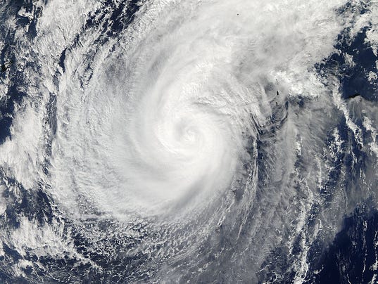
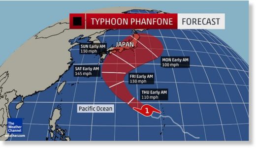
Phanfone strengthened from a Category 1 equivalent typhoon (75 mph estimated max winds) early Wednesday evening, local time (Japan is 13 hours ahead of U.S. EDT) to a Category 4 equivalenttyphoon (130 mph estimated max winds) early Thursday evening, local time, a jump of 55 mph (or 50 knots) in 24 hours.
"Phanfone had the dreaded pinhole eye rarely seen in tropical cyclones," said The Weather Channel hurricane specialist Michael Lowry. "The eye was so small even our best microwave satellites have trouble seeing it."
Typhoon Phanfone will continue to be in a favorable environment of low wind shear and high sea-surface temperatures through Friday. Therefore, additional strengthening is possible, possibly to super typhoon status (150 mph max sustained winds) for a brief time.
It should be noted intense tropical cyclones often go through eyewall replacement cycles, where a new outer eyewall cuts off, then replaces the old, inner eyewall. Tropical cyclones typically weaken a bit during this process, and the timing of these cycles is not able to be forecast using current technology.
Regardless of all that, the forecast track of this intense typhoon is critical.

Thursday, September 25, 2014

Butterfly swarm seen winging its way on weather radar


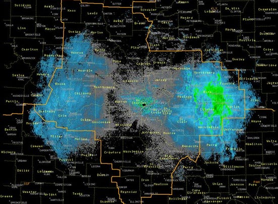
A swarm of butterflies, winging its way south for the winter, was "spotted" as large blue blobs on weather radar last week over southern Illinois and central Missouri.
"We think these targets are Monarch butterflies," the National Weather Service in St. Louis noted on its Facebook page, which also includes a technical explanation of how the weather service came to this conclusion.
The monarchs were flapping their way south toward their winter home in Mexico. As noted earlier this year, the colorful insects were under stress this spring because of ongoing drought, an unusually cold winter and a lack of milkweed, their primary food source.
This isn't the first time weather radar has "seen" bugs this year: Both grasshoppers in New Mexico and mayflies in Wisconsin were spotted on radar.
Scientists are finding that weather radar is proving useful to track birds, bats and insects. While this information is just clutter to the weather folks, it is just the thing biologists need to study the activities of flying creatures, a science newly christened "aeroecology."

Tropical Storm Rachel Strengthens Off the Coast of Mexico


Tropical Storm Rachel became the 17th named storm of the 2014 Eastern Pacific hurricane season Wednesday night, and is now gathering strength off the Mexican Pacific coast.
Wind shear, or changing wind direction and/or speed with height, is now weakening, and will allow Rachel to near hurricane-strength this weekend. Then, the system will track over cooler water and more stable air, inducing further weakening later in the weekend or early next week.
Rachel is forecast to move west-northwest over the next several days, before curling north sometime this weekend. While Rachel may indeed curl back toward the Baja peninsula next week, it is expected to have weakened to a tropical depression or remnant low if it ever makes it to land.
This is now the third busiest eastern Pacific hurricane season on record, as measured by the number of season-to-date named storms, according to The Weather Channel hurricane specialist Michael Lowry. Only 1992 (19 storms) and 1985 (20 storms) were busier, says Lowry.

Friday, September 19, 2014

California Wildfires: King Fire Balloons, More Evacuations Ordered


The latest round of evacuations comes as thousands of Californians have fled their homes in recent days, with about 200 structures across the state reduced to ash and hundreds of other homes and buildings still under threat from encroaching flames.
The fires are just three of at least nine fires burning across the state, part of an ongoing crisis indrought-plagued California.
State fire officials have already responded to more than 4,800 wildfires so far this year, USA Today reports, 1,000 more than an average fire season, and peak wildfire season is only just now underway.
"We've seen a lot more fires, and with those fires, more and more people are at threat. Every day we continue to see new fires ignite, forcing hundreds to evacuate," Cal Fire spokesman Daniel Berlant told USA Today.


Tropical Storm Fung-Wong Brings Flooding to Philippines, May Impact Taiwan Next


Tropical Storm Fung-Wong, known as Mario in the Philippines, brought heavy rain and gusty winds to portions of the northern Philippines. Over a foot of rain has already fallen in the mountainous terrain  and widespread flooding has been reported in Luzon.
Flooding was reported in Manila where according the the Associated Press. Three deaths have been reported as well.
Fung-Wong formed Thursday just east of the Philippines and is moving to the northwest, but will continue to bring rain and gusty winds to the northern Philippines through Saturday.
The Philippine Atmospheric, Geophysical and Astronomical Services Administration (PAGASA) warns that . Heavy rainfall is the greatest concern with .
Earlier this week, parts of the Philippines were impacted by Typhoon Kalmaegi.