Monday, October 31, 2016

Halloween Surprise: Rare Tropical Storm Forms in Mediterranean Sea

https://www.wunderground.com/news/medicane-tropical-storm-mediterranean-sea-31oct2016

A tropical storm formed Halloween weekend, not in the typical Atlantic or Pacific, but in the Mediterranean Sea.
This rather strange sequence of events began as an area of low-pressure dropped southward from southern Europe and became temporarily left behind by the jet stream over the central Mediterranean Sea south of the Italian coast.
By Saturday, Oct. 29, a non-tropical low pressure center formed east of Malta, a group of islands between Sicily and the coast of Libya over the weekend. 
RGB composite satellite image of the Mediterranean storm as it was making the transition to a subtropical storm on October 30, 2016, at 12:00 UTC.
(NERC Satellite Receiving Station, University of Dundee)
The next day, thunderstorms became more clustered near the low-pressure center to warm the mid levels of the atmosphere sufficiently to morph the system into a subtropical storm. 
A subtropical storm displays features of both tropical and non-tropical systems, including a broad wind field, no cold or warm fronts, and generally low-topped thunderstorms displaced from the center of the system. 

After El Niño, what weird weather could La Niña bring?

https://www.theguardian.com/news/2016/oct/23/el-nino-la-nina-drought-flood-weatherwatch

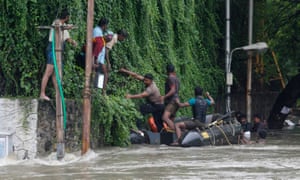
The strongest El Niño on record: flood waters in Chennai, India, in December last year.

This time last year the world’s weather was being dominated by one of the strongest El Niño events on record. As surface waters in the equatorial Eastern Pacific warmed by more than 2°C, a chain reaction of extreme weather events was set in motion. From torrential rains in Peru and huge storms pounding the coast of California, to drought and bushfire in Australia and Indonesia and catastrophic floods in south-east India (submerging parts of Chennai under eight metres of water), this El Niño really packed some punch. ByMay 2016 the El Niño conditions had gone, but the big question now is whether El Niño’s opposite phase – La Niña – is waiting in the wings?
La Niña, which is associated with abnormal cooling of equatorial Eastern Pacific waters, usually does follow El Niño, and in this case we’d expect to see La Niña emerge by the end of this year or in early 2017. And like El Niño, La Niña also tends to whip up some weird weather, often bringing cooler temperatures to many regions, drier conditions to East Africa and wetter weather over south-east Asia.
So far scientists have measured cooler than average sea surface temperatures in the Central Pacific, but this hasn’t spread further, and right now most climate models are predicting a return to average conditions for the Pacific, or at most a weak La Niña event. If La Niña does arrive then its cooling influence might cause a break in the string of global record-breaking warm months we’ve seen since March 2015, but without La Niña the world’s thermostat is likely to continue inching upwards.

'The atmosphere is being radicalized' by climate change

https://www.theguardian.com/environment/climate-consensus-97-per-cent/2016/oct/24/the-atmosphere-is-being-radicalized-by-climate-change

Climate change’s impacts on extreme weather and society are becoming increasingly clear and undeniable. While we are making progress in solving the problem, we’re still moving too slowly, and one of the two political parties governing the world’s strongest superpower continues to deny the science. This led astrophysicist Katie Mack to make the following suggestion, related to a common refrain from Donald Trump and Republican Party leaders:

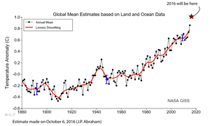
Average global surface temperatures.

Global warming intensified Hurricane Matthew

Hurricane Matthew set a number of records. Its record-breaking rainfall and storm surge caused historic flooding and destructive winds along the coasts of Florida, Georgia, the Carolinas, and Virginia. Hillary Clinton touched upon the science linking global warming and hurricane impacts in a recent speech in Florida:
At Climate Progress, Joe Romm summarized the various ways in which global warming makes hurricanes like Matthew more intense:
  • Hotter sea surface and upper ocean temperatures fuel hurricanes, leading to more of the strongest (Category 4 and 5) storms.
  • Hotter ocean temperatures also cause more rapid intensification of hurricanes, and the most intense storms are those that undergo rapid intensification.
  • Global warming causes sea level rise, which creates larger storm surges and thus worse flooding.
  • Global warming also adds more water vapor to the atmosphere, which causes more intense rainfall and exacerbates flooding.
In short, global warming made Hurricane Matthew and its impacts more severe, and will lead to more such devastating hurricanes in the future.


Landfalling Typhoons Have Become More Intense Over Last 40 Years

https://weather.com/news/climate/news/climate-central-landfalling-typhoons-more-intense

In the Northwest Pacific, already a hotspot for tropical cyclones, the storms that strike East and Southeast Asia have been intensifying more than those that stay out at sea over the last four decades, a new study finds.
The proportion of landfalling storms that reach Category 4 or 5 strength — the storms that wreak the most damage, as recent examples like 2013’s devastating Super Typhoon Haiyan show — has doubled and even tripled in some areas of the basin, researchers found. The increases seem to be the result of faster intensification linked to warmer ocean waters in coastal areas.
Super Typhoon Haiyan as it headed toward landfall in the Philippines, where it caused enormous destruction in November 2013. (NASA)
The findings, detailed Monday in the journal Nature Geoscience, are in line with the broader increase in the most intense tropical cyclones expected with rising global temperatures, though these trends have not yet specifically been linked to human-caused climate change.

‘Little Doubt’ Typhoons Intensifying

The Northwest Pacific normally sees the most tropical cyclone activity of any ocean basin because of the deep well of ocean heat available to fuel typhoons, as such storms are called there.
The new work is an outgrowth of a previous study by the same researchers that found that typhoon intensity had increasedbasin-wide since the late 1970s and suggested that another 14 percent increase in intensity could be expected by the end of the century, as the ocean takes up most of the excess heat trapped by greenhouse gasses.
Wei Mei, a tropical cyclone and climate researcher at the University of North Carolina at Chapel Hill, said that he and his colleagues were curious if typhoons in some parts of the basin were intensifying more than others. To investigate this, they grouped the typhoons into clusters based on where they formed and the paths they followed.
They found that the clusters that had the most landfalling hurricanes showed much clearer increases in intensity than those where most storms stayed out at sea. The cluster with the biggest trend had a 15 percent increase in intensity and, as part of that trend, saw the number of Category 4 and 5 storms increase from about one per year in the late 1970s to more than four per year recently.

Arctic's Melting Permafrost Problem Is Slowly Destroying Russian Cities

https://weather.com/news/climate/news/melting-permafrost-arctic-russia-buildings-destroyed

All over the world, climate change is altering our world in ways that are both obvious and subtle. Some effects of global warming change rapidly, while others are slow-moving disasters.
But in northern Russia, where the permafrost zone is shrinking as a side effect of climate change, towns are watching helplessly as their buildings are being deformed and even destroyed by the moving ground. In Norilsk, a town of 177,000 known for its nickel production, about 60 percent of the buildings have been deformed, according to a local report earlier this year.
The permafrost melt has forced more than 100 Norilsk homes to be abandoned, the Guardian also reported. It's the most polluted town in Russia, the report added, but despite the pollution and other issues, experts agree that the changing climate is as much to blame for the permafrost melt as anything else.
"In most cases, the effect of climate change was not accounted for properly or at all, so the story is not about one building falling, even though there are examples of that, but about thousands of people living in buildings which have the potential to fall," Dmitry Streletskiy, an assistant professor of geography at George Washington University, told the Guardian.


Fall Heat Wave Will Smash Records Into the First Days of November

https://weather.com/forecast/national/news/record-warmth-west-central-south-late-october
Record warmth will continue to give a summer feel into the first days of November this week, with hundreds of daily record highs and warm lows likely to be set, along with some monthly record highs in parts of the heat-weary South and Plains states.
Dozens of daily record highs were broken Monday, making it the hottest Halloween on record in those cities.
Halloween's record highs included Dodge City, Kansas (90 degrees), Garden City, Kansas (90 degrees), Asheville, North Carolina (81 degrees), Huntsville, Alabama (88 degrees), Tallahassee, Florida (90 degrees), Pensacola, Florida (89 degrees), and Fort Smith, Arkansas (89 degrees).
Atlanta also set a new record high Monday at 86 degrees, which is the latest on record that it has been that warm.
Denver finished the month of October with no measurable snow for the third-consecutive October, which is the first time this happened in Denver weather history, according to the National Weather Service in Boulder, Colorado.
Current Temperatures
    Some southern cities could set a new daily record high each day through much of this week.

    Sunday, October 30, 2016

    Chicago Bracing For Heavy Snowfall, Frigid Temps This Winter: Report


    This coming winter had a chilling effect on today's City Council budget hearing.
    Streets and Sanitation Commissioner Charles William said during the meeting the department is preparing for 16 inches of snow that could start falling as soon as Thanksgiving, the Chicago Sun-Times is reporting.
    William also reportedly told the council temperatures will be lower than normal in January and February.

    “It’s going to be a bad winter,” the newspaper reported Williams as saying.
    This year's El Nino is one of the strongest on record and it could have a big impact on winter weather across the nation, according to the latest forecast models.

    Despite predictions that the Chicago area will see another frigid winter this year, it appears El Nino could bring warmer than usual temperatures to the area during the winter months.
    El Nino is characterized by unusually warm sea surface temperatures in the Pacific Ocean along the equator. The shift in temperatures could cause a change in weather patterns thousands of miles away – including in Chicago.

    Forecasts from the National Oceanic and Atmospheric Administration predict the weather phenomenon will continue in the Northern Hemisphere through the winter, peaking in the late fall-early winter months. The event will likely weaken by spring of 2016, forecasters said.

    The National Weather Service Climate Prediction Center reported Illinois has an increased chance for above-average temperatures and below-average precipitation for the months of December, January and February.
    That doesn’t mean area residents won’t need their winter coats and snow shovels, however.
    According to the state climatologist, other factors come into play when determining the winter weather and even a mild winter can contain short periods of intense cold and heavy snow.

    "While temperature and precipitation impacts associated with El Niño are favored, El Niño is not the only player," Mike Halpert, deputy director of NOAA's Climate Prediction Center, said in a statement. "Cold-air outbreaks and snow storms will likely occur at times this winter. However, the frequency, number and intensity of these events cannot be predicted on a seasonal timescale."
    Last month, the Old Farmer’s Almanac predicted frigid weather in the Midwest this winter season.

    Source: City Bracing For Heavy Snowfall, Frigid Temps This Winter: Report | NBC Chicago http://www.nbcchicago.com/news/local/chicago-winter-snow-398954931.html#ixzz4Oby8h1NH

    President Obama Orders Government to Plan for 'Space Weather' Chaos

    Turning his attention to the heavens — and how turbulence there could create chaos on Earth — President Obama directed the federal government Thursday to come up with a plan to deal with "space weather." 
    Space weather, by the way, is a catch-all for disturbances in the area between the sun and Earth, such as solar flares, that wreak havoc on the electrical power grid, GPS systems, aviation equipment, satellites and other technology that have become integral to human life. 

    Image:

    The Aurora australis, also known as the southern lights, glows above the Earth on July 15, 2012. Joe Acaba / NASA via AP

    Particularly bad storms of this kind can bring down parts of the power grid, "resulting in cascading failures that would affect key services such as water supply, healthcare and transportation," according to an executive order Obama signed Thursday. "Space weather," the order adds, "has the potential to simultaneously affect and disrupt health and safety across entire continents." 
    The directive put several federal agencies on notice that they have six months to come up with a sweeping plan to predict and detect these interstellar events, alert the public, protect critical infrastructure and recover from the damage. That includes NASA, which will create a research program to "understand the sun and its interactions with Earth and the solar system. The president signed the order as he prepared for a daylong Frontiers Conference in Pittsburgh, where he planned to announce $300 million in spending on a variety of projects aimed at keeping the United States on the edge of technological innovation over the next 50 years, from understanding Alzheimer's disease and road traffic to preventing biased policing to putting a person on Mars.

    (Source)

    Be aware of these 5 fall weather trends

    Fall's reputation for clear, calm days doesn't always hold true. This can particularly be the case later in the season for some parts of the country.
    Given it's a transitional time of year, there can be a little taste of everything: snowstorms, tornado outbreaks and even hurricanes. Here are five fall weather threats that are possible each year.

    1.) A Second Tornado Season

    The greatest chance of tornadoes in November is near the Gulf Coast.
    The second half of October and especially November can often be a second season for tornadoes and severe thunderstorms.
    With cold fronts and jet stream winds becoming stronger in the fall and warm, moist air available at times, the atmosphere can become unstable. As a result, severe thunderstorms with damaging winds, large hail and sometimes tornadoes can develop.
    Most of the time, the second-season tornado outbreaks are in the Gulf Coast states where warm and moist air is more common, but they can sometimes spread farther north.
    One such outbreak that occurred well away from the Gulf Coast occurred on Nov. 17, 2013. On that day, damaging tornadoes touched down in several Ohio Valley and Great Lakes states.
    The largest fall tornado outbreak struck the South Nov. 21-23, 1992. A total of 105 tornadoes touched down in the three days, killing 26 people.

    2.) 'November Witch' Storms With Strong, Damaging Winds

    Strong low pressure system that affected the Great Lakes on Nov. 12, 2015 with high winds.(NOAA)
    As temperature contrasts increase from north to south across the country, storm systems that develop are stronger in fall. The more intense those low pressure systems become, the stronger the winds they can produce.
    Early November – and late October, for that matter – have a long, notorious history of intense Midwest windstorms. If you live in that region of the country, you may have heard the phrase "witches of November" used to describe these storms that often pack powerful winds.
    Those low pressure systems can have winds so strong that they cause tree damage and power outages. One such "November Witch" struck parts of the Midwest and Great Lakes in early November of last year, downing trees and causing power outages.
    The storms are also a major hazard for shipping on the Great Lakes. One of the most well known storms sank a huge iron-ore ship called the Edmund Fitzgerald while it was on Lake Superior in November 1975.

    3.) Wet Snow

    Big snowstorms in fall can sometimes be destructive.
    The heavy, wet nature of most early-season snowfalls can weigh down tree branches and power lines, causing them to break.
    Also playing a role is the fact that many trees may still have their leaves, adding extra weight to branches already being weighed down by snow.
    Add the force of strong winds to this, and you could have a widespread mess of downed trees and power outages, sometimes lasting for days.
    One such storm dubbed "Snowtober" struck the Northeast Oct. 29-30, 2011.
    Satellite image from Oct. 30, 2011, showing the swath of snow produced by Snowtober from West Virginia to southern New England.(NOAA)
    This rare, major October snowstorm dumped more than a foot of snow from northeast Pennsylvania to southern Maine. Incredibly, parts of Massachusetts and New Hampshire saw more than 30 inches.
    Trees were damaged and power lines were downed by the heavy, wet snow, causing more than 3 million to lose power. In some of the hardest hit areas, power was out for more than a week.

    4.) Santa Ana Winds 

    Typical Santa Ana setup.
    Fall is the time of year when Santa Ana winds make a return to Southern California. These wind events are most common September through March.
    Strong high-pressure systems that build into the interior West help to send offshore winds from the northeast or east through the canyons and passes located in the mountains of Southern California.
    These wind events can have several impacts on Southern California, including:
    • Low humidity levels, which makes the danger of wildfires high.
    • Wind damage that can fan any ongoing wildfires.
    • Wildfire danger is typically the highest in the fall because the vegetation is dry since Southern California is coming out of its summer dry season.
    • The air that descends after passing over the mountains compresses and warms up, resulting in warmer-than-average temperatures in the valleys of Southern California. This is the reason why temperatures have been as hot as the upper 90s and even near 100 degrees into early November in Los Angeles.

    5.) Hurricane Season Comes to a Close, But You Can't Let Your Guard Down Yet

    Hurricane Wilma makes landfall in southwest Florida on Oct. 24, 2005.(NOAA)
    As we saw with Hurricane Matthew in early October, the hurricane season still needs to be closely watched in October and into November,
    In recent years there have been disastrous hurricanes impact the U.S. in late October, including Sandy in 2012 and Wilma in 2005.
    Though exceedingly rare, three hurricanes have struck the U.S. in November. In 1985, Hurricane Kate made landfall in Florida just days before Thanksgiving.
    November as a whole averages about one named storm every two years in the Atlantic.
    The Atlantic hurricane season officially ends Nov. 30, but tropical storms and hurricanes can still develop even after that date.

    How does 2016's World Series forecasted weather match up with 1995 and 1997's?

    CLEVELAND, Ohio – The Indians made it to the World Series, Cleveland! The first time since 1997. Game 1, this Tuesday, Oct. 25, is forecasted to be in the mid 40s, with thankfully near zero rain chances.
    What's the weather for Cleveland Indians World Series Game 1 and Cavaliers opener on Oct. 25?
    Meteorologist Kelly Reardon takes an early look at the weather expected for Game 1 of the World Series and the Cleveland Cavs season opener on Tuesday, Oct. 25.

    So, wear a warm coat, bring your Tribe hats and gloves, and give thanks that the weather is better than the chilly World Series in 1997.
    Screen Shot 2016-10-24 at 9.09.38 AM.pngNote: All temperatures are from first pitch. Red denotes home games, grey denotes away games. Games 5, 6, and 7 of this year's World Series are pending on the results of Games 1 through 4. 
    1995: The games played in Cleveland against the Braves were definitely pretty warm for late October, in the 50s with no rain. Talk about perfect game weather for both fans and players!
    1997: The games played in Florida were obviously very toasty compared to Cleveland, in the mid 70s to 80s. Here in 1997, games 3 and 5 weren't bad, in the high 40s to 50s. It was game 4 that was notably chilly, with game temperatures starting at 41 degrees which dropped to the mid 30s - burr!
    For the fans, the game was spent bundled up head to toe with star-struck eyes peeping between their scarves and hats.
    BALTA  SNOWDENBaltna Snowden, of Wooster, Ohio, is bundled up from the cold as she waits for the start of Game4 of the World Series at Cleveland's Jacobs Field, Wednesday, Oct. 22, 1997. Temperatures at game time were in the 30s with snow flurries.  
    2016: This year, we're looking quite a bit warmer than in 1997, making it much easier to cheer in the stands! The first two games' start temperatures are in the mid 40s -- definitely doable.
    However, Tuesday it's looking there will be some rain, so that'll make it a bit harder for the players, but if you're lucky enough to be in the stands, definitely bring a rain coat.
    If games 6 and 7 occur, they'll be in Cleveland, in the mid 50s with only slight chances of rain for now.

    How bad is this winter's weather going to get?

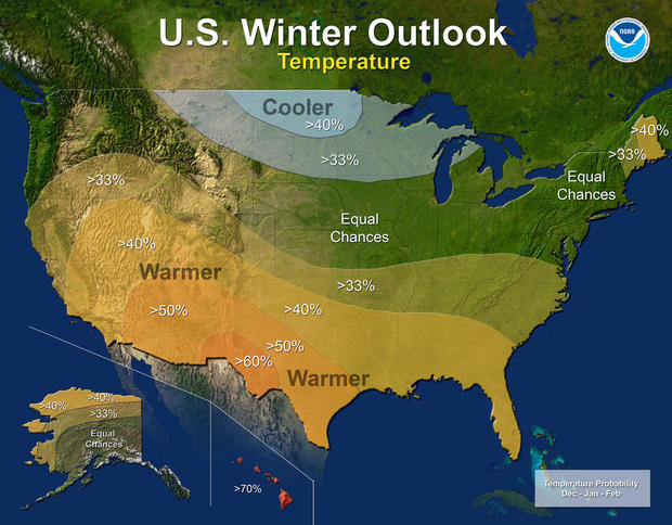
    WASHINGTON -- Federal forecasters predict this winter may paint the U.S. in stripes of different weather: Warmer and drier than normal in the south, and colder and wetter than usual in the far north.
    The National Weather Service winter outlook, issued Thursday, gets murky in the nation’s middle belt, with no particular expectation for trends in temperature or precipitation.
    Still, some nasty storms might make the winter there memorable, said Mike Halpert, deputy director of the weather service’s Climate Prediction Center.
    winteroutlook1.jpg
    This map provided by NOAA shows the winter temperature outlook for the U.S. 
     NOAA VIA AP
    The major driver of the winter forecast is a budding La Niña, a cooling of the central Pacific that warps weather worldwide and is the flip side of the better-known El Niño, Halpert said.
    For the South and California, “the big story is likely to be drought,” Halpert said.
    And that’s not good news for California, which is in year five of its drought. The winter is the state’s crucial wet season when snow and rain gets stored up for the rest of year. Halpert said the state’s winter looks to come up dry, especially in Southern California.
    “It’s probably going to take a couple of wet winters in a row to put a big dent into this drought now,” said weather service drought expert David Miskus. He said it will take “many, many years and it’s got to be above normal precipitation.”
    The northern cold band that the weather service predicts is mostly from Montana to Michigan. Maine is the exception, with unusually warm weather expected.
    The prediction center’s track record on its winter outlooks is about 25 percent better than random chance for temperature and slightly less than that for precipitation, Halpert said.
    Private weather forecasters are predicting quite a different winter. They foresee a harsher one for much of the nation, including a return of the dreaded polar vortex, which funnels cold Arctic air into the U.S.
    Judah Cohen of Atmospheric and Environmental Research in Lexington, Massachusetts, forecasts an unusually cold winter for the eastern and middle two-thirds of the nation, especially raw east of the Mississippi River.
    Cohen, whose research is funded by the National Science Foundation and closely followed by meteorologists, links North America’s winter weather to Siberian snow cover in October.
    He agrees that Maine will have a warm winter, and also predicts a warm Southwest.
    The private Accuweather of State College, Pennsylvania, calls for frequent storms in the Northeast, early snow in the Great Lakes, bitter cold in the northern tier and occasional cold in the middle. Like other forecasters, it predicts a warm and dry southwest, with some hope for rain and snow from San Francisco northward.