Saturday, August 31, 2013


More Severe Storms Target Midwest

Published: Aug 31, 2013, 6:50 AM EDT weather.com

http://bcove.me/6x0c84vk
Kicking off the Labor Day holiday weekend, another round of severe thunderstorms is expected to erupt in parts of the Plains and Midwest.
Background

National Forecast: Next 12 Hours

National Forecast: Next 12 Hours
Saturday, sufficient moisture and instability coupled with an advancing jet-stream level disturbance will fire off strong thunderstorms in the northern Plains from the eastern Dakotas into Minnesota Saturday afternoon, spreading southward into eastern Nebraska, western Iowa, southern Minnesota and possibly northern Kansas and northwest Missouri Saturday night into early Sunday morning.   
The main threat from these storms will be large hail, high winds and frequent lightning. That said, a tornado or two may touch down in parts of northern Minnesota or the eastern Dakotas.
Scattered thunderstorms will also flare up from the Ohio Valley into the Appalachians, New England, Florida and the northern Gulf Coast. A brief damaging wind gust, along with heavy rain and frequent lightning, is possible only in the strongest storms.
Thunderstorms will also be plentiful from the Desert Southwest into the central Rockies with a deep plume of moisture in place. Flash flooding (along with frequent lightning) is the primary threat from the Mojave Desert of California into southern Nevada, Arizona, Utah, Colorado and far northern New Mexico. 

Jacqueline Hennessy


http://www.weather.com/news/peru-heavy-snow-20130829
The Southern Hemisphere is just weeks away from a winter-to-spring transition, but in southern Peru, a heavy snowstorm has crippled life for thousands of residents.
Approximately 12,000 families are stranded after at least three feet of snow fell in the city of Puno's Carabaya province, according to Peru This Week. 
With food and medicine running short in the snow- and ice-covered areas, the government made air deliveries of necessary supplies, reports the Wall Street Journal. At least one person has died and many others have suffered damage to their homes due to the heavy snowfall.
"Temperatures typically tumble below freezing at this high elevation this time of year (late winter)," said weather.com senior meteorologist Jon Erdman. "However, precipitation is typically sparse in late-August in southeast Peru, so picking up over an inch of snow can make travel difficult in this high terrain."
The heavy snowfall has been devastating to livestock as well. According to a Reuters video, more than 250,000 alpacas have died, unable to find food in the bleak conditions. Other animals have died from being trapped under blizzard conditions.
A state of emergency has been declared for much of the region, located in the Andes mountains.

Friday, August 30, 2013

Arctic Sea Ice

In 2012 the summer sea ice in the Arctic Ocean reached a minimum, this year it is expected to be greater.

http://www.bbc.co.uk/weather/feeds/23904997

A new map released by the National Oceanic and Atmospheric Administration (NOAA) paints a stunning portrait of North America's ongoing battle against wildfires. The map, based on six months of data collected from NOAA's GOES satellites, shows a continent glowing with autumnal hues, each dot representing a wildfire picked up by one of NOAA's satellites.
But don't be alarmed if North America seems unusually ablaze. Plots on the graphic represent the lump sum of fire signatures picked up by all of NOAA's satellites, not the actual total number of fires. In layman's terms: if two satellites pick up a thermal signature for the same fire they both record a separate plot on the map. All of that plotting ads up to 323,828 dots, well above the 34,064 fires observed by the National Interagency Fire Center (NIFC) so far in 2013. 
Play Video
Overlay

Fighting Fire From Above

Autoplay
ON
OFF
It's also important to note that the map plots individual fires, not acreage burned. That means the points on the map portray large wildfires, particularly endemic in 2013 to the West and Southwest, with equal weight to smaller, less damaging blazes. That caveat goes a long way toward explaining the Southeast United States, which despite enjoying a relatively mild wildfire season to date, Wired reports, looks as though it had a run in with a two-year-old and a pack of highlighters. 
Regardless of its deficiencies the map illuminates an interesting trend in wildfire progression: as the seasons change, so too do the geographic locales of wildfires. In early spring, agricultural fires sprout up in the Southeast before making a general push West, where drought-related infernos, like the ongoing Rim Fire in California, take hold in the Western mountain ranges. According to the NIFC, all 28 ongoing wildfires are burning in the West, reinforcing this trend. 
So where does this wildfire season stand historically? Even though fires continue to rage on in the West, the wildfire season thus far remains relatively timid. To date, there have been 9,868 fewer wildfires in 2013 than there were in 2012, and more tellingly, more than 3 million less acres scorched. Last year's season was the third worst in terms of acreage burned since the NIFC started recording data in 1960, continuing an upward trend in large wildfires over the past 30 years. 


The Impact of Floods in Sudan

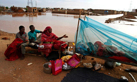
MDG : Floods in Sudan : A Sudanese homeless family rest on the side of a highway in Khartoum
Forty-eight people have been killed and more than 500,000 affected by the worst floods in Sudan in quarter of a century.
The region around the capital, Khartoum, was particularly badly hit, with at least 15,000 homes destroyed and thousands of others damaged. Across Sudan, at least 25,000 homes are no longer habitable. A UN official described the situation as a disaster.
The flooding, caused by continuous rains, has damaged public buildings, including schools, clinics, offices, shops, markets and water and sanitation facilities. Roads have been inundated, disrupting transport.
One of the major health worries is the collapse of more than 53,000 latrines; the World Health Organisation (WHO) has warned of an increase in malaria cases in the past two weeks.
WHO and Unicef, the UN agency for children, are supporting Sudanese authorities and national NGOs to run 50 emergency health clinics. The centres will be open for two months in eight states – Khartoum, White Nile, El Gezira, River Nile, Northern, Blue Nile, North Darfur and South Darfur.

Flash Floods in Yemen


photo_1376752958281-1-HD.jpg

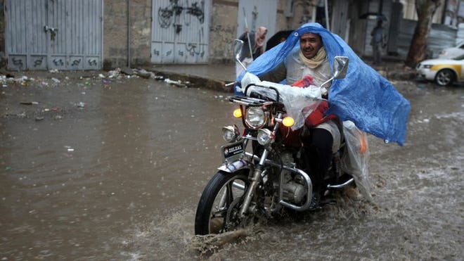
Lightning and flash floods have killed 50 people in Yemen since Friday, including 27 who died when a torrent washed away a wedding convoy, local officials said Saturday.
Storms have battered the Arabian Peninsula country since Friday, triggering flash floods in several areas that killed 41 people, while nine others, including a soldier, were struck by lightning and died


Read more: http://www.foxnews.com/world/2013/08/17/lightning-flash-floods-kill-50-in-yemen/#ixzz2dV77iXlS

Midwest Drought: Hot, Dry Spell Brings Back Crop Concerns

David Pitt Published: Aug 30, 2013, 8:19 AM EDT Associated Press
Overlay

Drought in West Getting Worse

Autoplay
ON
OFF
DES MOINES, Iowa -- A growing season that began unusually wet and cold in the Midwest is finishing hot and dry, renewing worries of drought and its impact on crops.
"Over the last couple of months, drought conditions have expanded in the Midwest from northern Missouri to portions of Minnesota and the eastern Dakotas," said weather.com meteorologist Chris Dolce. "Severe drought conditions now exist in parts of central Iowa and northern Missouri. As of Aug. 30, Des Moines, Iowa has seen under an inch of rain for the month. The total rainfall deficit since June 1 has grown to more than eight inches."
Temperatures soared to records in recent days in parts of the region, reaching nearly 100 degrees in some areas.
"It's about the worst case scenario we could have with these high temperatures and the lack of water with soil moisture declining," said Roger Elmore, an agronomy professor at Iowa State University.
Background

Latest National Drought Status

Latest National Drought Status
A wet, cool spring delayed planting and slowed crop growth - but it also replenished soil moisture in many crop producing states, causing some of last year's widespread drought to retreat. The rain stopped in July in many of those states, however, and as the soil dried out, the heat set in and stressed corn and soybean crops.
The southeast Iowa city of Burlington, which is surrounded by corn fields, had its wettest spring on record at 19.23 inches of precipitation, nearly 8 inches above normal. Yet it's now on track to have its driest summer on record, with only 3.86 inches so far, 8.41 inches below normal.
Wayne Humphries farms about 1,000 acres about 45 miles north of Burlington at Columbus Junction. He grows corn and soybeans and raises hogs.
He said he delayed planting by about 30 days because of wet fields and now is watching the lower leaves of cornstalks turn brown from lack of moisture. He hasn't seen a measurable rain for 30 days.
Soybean plants are suffering too as seeds are developing in the pods.
"I have solace in the fact that we did everything we could and we did it to the best of our ability and now whatever happens, happens," he said. "It's sort of a philosophical moment."
Corn and soybeans have developed enough that weather conditions are not likely to reduce the number of kernels on the corn cob or the seeds in soybean pods. But those kernels and seeds could develop smaller and weigh less, which could reduce the harvest this fall, Elmore said.
Unless it's a drastic reduction, it's unlikely to affect consumer prices at the grocery store. A shortage of corn and soybeans from a bad year would likely have a more immediate impact on meat prices because it costs more for livestock farmers to feed their herds.
The crops are holding up good. In another week or so, they are going to need a drink.
Dean Stoskopf, farmer
The dry conditions aren't confined to Middle America: for the first time since early April, more than half of the country is now in some stage of drought, according to the weekly U.S. Drought Monitor report released Thursday. That includes much of the West, where the hot, dry weather has fueled wildfires.
Drought conditions surged in the past week in corn-producing states, up to 45 percent of the region from 25 percent the week before, said Brad Rippey, a meteorologist with the U.S. Department of Agriculture. Soybeans in drought also increased sharply in the last week to 38 percent from 16 percent, he said.
In northwest Kansas, farmer Brian Baalman watched the temperature reach 94 degrees on his truck thermometer Wednesday. He farms about 30 miles west of Colby, where corn plants are turning white and ears are drooping as the heat kills the corn that's not irrigated.
"We are basically back to where we (were) in the moisture situation before the rain came, you know," he said. "Go west of me and it is a lot different, drier yet, and folks are worse off than we are," he said.
Lack of rain has caused drought conditions to expand in most of Wisconsin and Minnesota, along with eastern Illinois, western Indiana and northern Michigan, and parts of Texas, Arkansas, and Louisiana, according to the drought report.

Tropical Storm Kong-Rey: 3 Dead as Storm Floods Taiwan

Published: Aug 30, 2013, 7:25 AM EDT Associated Press
Overlay

19 Inches of Rain from Typhoon

Autoplay
ON
OFF
TAIPEI, Taiwan -- Three people in Taiwan perished as a result of heavy rains spawned by a destructive tropical storm, the government said Friday.
Tropical Storm Kong-Rey battered the island Thursday, dumping more than 19 inches of rain on the heavily populated west coast and causing widespread flooding.
The government's emergency operations center said one of the fatalities occurred when a man in Pingtung county in Taiwan's far south drowned after being thrown into a river from his skidding motorbike. Farther to the north in Yunlin country, one woman was electrocuted in her home after heavy flooding and another woman drowned.
Kong-Rey skirted the island's east coast on Thursday before heading north toward Japan.
Particularly hard hit in Taiwan were the large west coast cities of Chiayi, Tainan and Kaohsiung, where flooding in some areas reached second-story levels. Officials evacuated a total of 3,600 residents and cancelled some train services.
Kong-Rey is the second major storm to hit Taiwan this month. Last week, a severe tropical storm dumped up to a meter (39 inches) of rain on the southern part of the island. High winds caused the cancellation of scores of international flights and in conjunction with the rain led to the disruption of high speed rail service between the capital of Taipei and Kaohsiung.

Local residents walk through floodwaters from passing Tropical Storm Kong-Rey in Tainan, Taiwan, Thursday, Aug. 29, 2013. (AP Photo)

Wildfire Map: NOAA's Satellites Show North America Ablaze

By Eric Zerkel weather.com

This map provided by NOAA shows six months of wildfires in North America as captured by NOAA's satellites.
A new map released by the National Oceanic and Atmospheric Administration (NOAA) paints a stunning portrait of North America's ongoing battle against wildfires. The map, based on six months of data collected from NOAA's GOES satellites, shows a continent glowing with autumnal hues, each dot representing a wildfire picked up by one of NOAA's satellites.
But don't be alarmed if North America seems unusually ablaze. Plots on the graphic represent the lump sum of fire signatures picked up by all of NOAA's satellites, not the actual total number of fires. In layman's terms: if two satellites pick up a thermal signature for the same fire they both record a separate plot on the map. All of that plotting ads up to 323,828 dots, well above the 34,064 fires observed by the National Interagency Fire Center (NIFC) so far in 2013. 
Play Video
Overlay

Fighting Fire From Above

Autoplay
ON
OFF
It's also important to note that the map plots individual fires, not acreage burned. That means the points on the map portray large wildfires, particularly endemic in 2013 to the West and Southwest, with equal weight to smaller, less damaging blazes. That caveat goes a long way toward explaining the Southeast United States, which despite enjoying a relatively mild wildfire season to date, Wired reports, looks as though it had a run in with a two-year-old and a pack of highlighters. 
Regardless of its deficiencies the map illuminates an interesting trend in wildfire progression: as the seasons change, so too do the geographic locales of wildfires. In early spring, agricultural fires sprout up in the Southeast before making a general push West, where drought-related infernos, like the ongoing Rim Fire in California, take hold in the Western mountain ranges. According to the NIFC, all 28 ongoing wildfires are burning in the West, reinforcing this trend. 
So where does this wildfire season stand historically? Even though fires continue to rage on in the West, the wildfire season thus far remains relatively timid. To date, there have been 9,868 fewer wildfires in 2013 than there were in 2012, and more tellingly, more than 3 million less acres scorched. Last year's season was the third worst in terms of acreage burned since the NIFC started recording data in 1960, continuing an upward trend in large wildfires over the past 30 years. 

Weather could be controlled using lasers

Scientists are attempting to control the weather by using lasers to create clouds, induce rain and even trigger lightning.


Experts from around the world are to gather at the World Meteorological Organisation next month to discuss how powerful laser pulses can be used to generate changes in the atmosphere that influence the weather.
Their experiments have shown that intense pulses of light can cause ice to form and water to condense, leading to the formation of clouds.
The scientists have now begun testing their equipment outside for the first time with extremely short pulses of laser light were fired into the sky.
Researchers have also proved that lightning discharges can be triggered and channelled through the air using laser pulses.
They hope the technology could allow lightning during thunderstorms to be guided away from sensitive buildings such as power plants or airports
Scientists are attempting to control the weather by using lasers to create clouds, induce rain and even trigger lightning.
It could also be used to manipulate the weather by creating clouds and triggering rainfall ahead of major public events.
Professor Jean-Pierre Wolf and Dr Jerome Kasparian, both biophotonics experts at the University of Geneva, have now organised a conference at the WMO next month in an attempt to find ways of speeding up research on the topic.
They said: “Ultra-short lasers launched into the atmosphere have emerged as a promising prospective tool for weather modulation and climate studies.
“Such prospects include lightning control and laser-assisted condensation.”
There is a long history of attempts by scientists to control the weather, including using techniques such as cloud seeding.
This involves spraying small particles and chemicals into the air to induce water vapour to condense into clouds.
In the 1960s the United States experimented with using silver iodide in an attempt to weaken hurricanes before they made landfall.
The USSR was also claimed to have flown cloud seeding missions in an attempt to create rain clouds to protect Moscow from radioactive fallout from the Chernobyl nuclear disaster.
More recently the Russian Air force has also been reported to have used bags of cement to seed clouds.
Before the 2008 Olympic Games in Beijing, the Chinese authorities used aircraft and rockets to release chemicals into the atmosphere.
Other countries have been reported to be experimenting with cloud seeding to prevent flooding or smog.
However, Professor Wolf, Dr Kasparian and their colleagues believe that lasers could provide an easier and more controllable method of changing the weather.
They began studying lasers for their use as a way of monitoring changes in the air and detecting aerosols high in the atmosphere.
Experiments using varying pulses of near infra-red laser light and ultraviolet lasers have, however, shown that they cause water to condense.
They have subsequently found the lasers induce tiny ice crystals to form, which are a crucial step in the formation of clouds and eventual rainfall.
In new research published in the Proceedings of the National Academy of Sciences, Professor Wolf said the laser beams create plasma channels in the air that caused ice to form.
He said: "Under the conditions of a typical storm cloud, in which ice and supercooled water coexist, no direct influence of the plasma channels on ice formation or precipitation processes could be detected.
“Under conditions typical for thin cirrus ice clouds, however, the plasma channels induced a surprisingly strong effect of ice multiplication.
“Within a few minutes, the laser action led to a strong enhancement of the total ice particle number density in the chamber by up to a factor of 100, even though only a 10−9 fraction of the chamber volume was exposed to the plasma channels.
“The newly formed ice particles quickly reduced the water vapour pressure to ice saturation, thereby increasing the cloud optical thickness by up to three orders of magnitude.”
Another paper in the journal of Applied Physics Letters also indicated that ultraviolet lasers were far more efficient at producing condensation.
In March this year, Professor Wolf and his team also tested a high powered 100 terawatt laser in the field by firing it into the sky above a research centre in frascati, near Rome in Italy.
He said: "The aim of the experiment is to investigate the scaling up of the water condensation experiments already demonstrated at lower intensities."
Professor Jean-Claude Diels, from the department of Physics at the University of New Mexico in Albuquerque, will talk at the conference on how laser pulses can be used to guide lightning.
Previous attempts to guide lighting have used rockets towing wires as they were fired into storm clouds.
Laboratory tests by Professor Diels, however, have shown that electrical discharges can be guided along the path of a laser beam.
Their work has raised hopes that pulses of light can be used to steer lightning strikes away from buildings, vehicles and areas where they would be dangerous to humans.
Professor Diels said: “We are investigating a scaling up of these experiments across larger gaps. An application being investigated is the triggering and guiding of lightning.”

Dry weather helps Minn. farmers harvest grains

ST. PAUL, Minn. (AP) -- Dry weather is helping Minnesota farmers with the small grain harvest, but it's also hurting crop conditions.
The U.S. Department of Agriculture said Monday that Minnesota's spring wheat harvest has reached 65 percent complete. That's nearly up to the normal harvesting pace of 66 percent.
The oat harvest is now 80 percent complete, slightly behind normal.
But crop conditions continue to decline as dry weather persists. An average of only 0.31 inch of rain fell last week, 0.50 inch below normal. But there was marginal improvement in the condition of sunflowers.
Soybean conditions declined slightly to 54 percent good or excellent.
Warmer-than-normal temperatures and continued sunny days combined for 6.6 days suitable for fieldwork. Topsoil and subsoil moisture levels continued to decline.

Thursday, August 29, 2013

Global warming slowdown linked to cooler Pacific waters


Scientists say the slow down in global warming since 1998 can be explained by a natural cooling in part of the Pacific ocean.
drought

Although they cover just 8% of the Earth, these colder waters counteracted some of the effect of increased carbon dioxide say the researchers.
But temperatures will rise again when the Pacific swings back to a warmer state, they argue.
The research is published in the journal Nature.
Climate sceptics and some scientists have argued that since 1998, there has been no significant global warming despite ever increasing amounts of carbon dioxide being emitted.
For supporters of the idea that man made emissions are driving up temperatures, the pause has become increasingly difficult to ignore.
Scientists have tried to explain it using a number of different theories but so far there is no general agreement on the cause.
"For people on the street it is very confusing as to which story is closer to the truth," lead author, Prof Shang-Ping Xie from the Scripps Institution of Oceanography told BBC News.
"We felt a similar contradiction and that's why we started doing these modelling studies."
Cooling the carbonAlthough it only covers 8.2% of the planet, the region is sometimes called the engine room of the world's climate system and atmospheric circulation.
Prof Xie said there were two possible reasons why the continuing flow of CO2 has not driven the mercury higher.
The first is that water vapour, soot and other aerosols in the atmosphere have reflected sunlight back into space and thereby had a cooling effect on the Earth.
The second is natural variability in the climate, especially the impact of cooling waters in the tropical Pacific ocean.


Source: http://www.bbc.co.uk/news/science-environment-23854904

Huge canyon discovered under Greenland ice


One of the biggest canyons in the world has been found beneath the ice sheet that smothers most of Greenland.


The canyon - which is 800km long and up to 800m deep - was carved out by a great river more than four million years ago, before the ice arrived.  


It was discovered by accident as scientists researching climate change mapped Greenland’s bedrock by radar.  
The British Antarctic Survey said it was remarkable to find so huge a geographical feature previously unseen. 
The hidden valley is longer than the Grand Canyon in Arizona. It snakes its way from the centre of Greenland up to the northern coastline and before the ice sheet was formed it would have contained a river gushing into the Arctic Ocean. Now it is packed with ice.The ice sheet, up to 3km (2 miles) thick, is now so heavy that it makes the island sag in the middle (central Greenland was previously about 500m above sea level, now it is 200m below sea level).The canyon still runs “downhill”, though, and meltwater from the ice sheet seeps out below sea level at the northern end – at a relative trickle, rather than a torrent. Glaciologists think the canyon plays an important role in transporting sub-glacial meltwater produced at the bed towards the ocean. 
Read more (click below): 
http://www.bbc.co.uk/news/science-environment-23866810 


Haboob in Phoenix


A huge dust storm, called a "haboob," blasted through Phoenix and the surrounding metro area on Monday evening.  ?Around sundown, winds from an approaching storm pushed a hazy brown cloud over most of the Phoenix area, bring low visibility and gusty winds in its wake.  
At peak intensity the haboob caused wind gusts of more than 60 miles per hour and a dust storm warning was issued as visibility in the area dropped below 1/4 of a mile.  
There were no immediate reports of any injuries or property damage, but images from social media did show some uprooted trees.
Phoenix Sky Harbor Airport initiated a ground stop, temporarily halting all inbound and outbound flights.  Flights are expected to resume later Monday evening.
After the dust storm passed, moderate rain began to fall in and around Phoenix, washing away the dust but causing additional problems of its own.  Some parts of southern Arizona have been dealing with flash flooding.
The Mohave Daily News reported that rain in the Bullhead City area closed several roads on Sunday as runoff deposited mud, rocks and debris in low-lying areas.
This is the second large haboob for Phoenix in the last six weeks.  On July 12th another large dust storm swept the city.