Friday, October 30, 2015

Severe Storms in Texas may Cause Tornadoes

CSkxQMuUEAQ72p6.jpg

Several reported tornadoes left damage in small towns near San Antonio, Texas, on Friday morning. In those areas, as well as near Austin, a flood emergency forced people to evacuate their homes.
The flash flood emergency was in effect for much of Comal County, as well as parts of Hays and Bexar counties, according to the National Weather Service. This includes areas like northern San Antonio and New Braunfels.


http://www.weather.com/storms/severe/news/severe-weather-impacts-southern-plains-texas

Thursday, October 29, 2015

>>>>>>Watch a video<<<<<< of a Wet microburst

https://youtu.be/a_G2KRzha7o


Rain Bomb: Rare 'Wet Microburst’ Caught on Camera in Stunning Timelapse

A STORM chaser captures a huge burst of wind and rain which explodes in the sky and crashes to the ground. Shot on August 8, this dramatic timelapse was shot by photographer Bryan Snider, 29, in Tucson, Arizona. The incredibly detailed footage shows a weather event known as a wet microburst which occurs when a cooled column of air sinks rapidly through the middle of a thunder storm. The unique storm phenomena affects an area of no more than two and a half miles and can generate winds of over 150 mph. New Mexico-born Bryan lives and works in Phoenix, Arizona, as a full time videographer.

Videographer / Director: Bryan Snider, LSM
Producer: Mark Hodge, Chloe Browne
Editor: Joshua Douglas

Chicago Area Sets Record for Most Tornadoes in a Year in 2015


The severe weather season in northern Illinois typically doesn’t start heating up until late April, and the season generally peaks in June, but this year it started fast and furious. 
 
An unusually strong early spring storm system moved into the Midwest on Apr. 9, 2015. A northward push of humid, unstable air collided with cool, dry air draining down from the Plains. The perfect recipe for an early season tornado outbreak.
 
 
**Radar image of a tornado-producing supercell thunderstorm on the night of Apr. 9, 2015, near Rochelle, Illinois. 
                
 
The result was 14 tornadoes across the central U.S. that day, seven of which tore through northern Illinois. One of them was an EF-4 on the Enhanced Fujita Scale, which caused extensive damage in Rochelle, Illinois and surrounding areas. That EF-4 remains the strongest tornado reported in the U.S. so far in 2015.


HIGH TIDES IN SOUTH CAROLINA


**High tide, third highest on record, set Tuesday morning in Charleston, South Carolina, on October 27, 2015. (NOAA)

Only three events produced higher tides at Charleston Harbor: Hugo on Sep. 21, 1989 (12.56 feet), an August 11, 1940 hurricane (10.27 feet) and a New Year's Day 1987 coastal storm (8.84 feet) produced higher tides at Charleston Harbor.

Tuesday's tide level was 4-5 inches higher than the peak measured during the historic South Carolina flooding and coastal flooding event earlier in October. Fortunately this time, there wasn't 17-27 inches of rainfall occurring at the same time.


We mentioned earlier, there was no tropical storm, hurricane, or even bullish coastal low-pressure system associated with this event.

Instead, the pressure gradient between strong high pressure centered over the Northeast U.S. and low pressure over the northern Gulf Coast set up the persistent east to northeast winds driving water ashore.

http://www.weather.com/storms/severe/news/charleston-south-carolina-georgia-coastal-flooding

RECAP OF HURRICANE PATRICIA

Hurricane Patricia was a tropical cyclone that formed in the eastern Pacific and rapidly intensified into a Category 5 hurricane. Even more quickly than the storm strengthened, it rapidly weakened over the rugged terrain of Mexico.
Patricia initially formed on Oct. 20, 2015 and dissipated on Oct. 24, 2015.

Looking Back at Patricia

Just 30 hours after peaking in intensity as the most powerful tropical cyclone ever measured in the Western Hemisphere, former Hurricane Patricia degenerated into a weak remnant low over northeast Mexico.
On Oct. 23, Patricia became the most powerful tropical cyclone ever measured in the Western Hemisphere as its maximum sustained winds reached an unprecedented 200 mph (320 kph) and its central pressure fell to 879 millibars (25.96 inches of mercury).


Data from an Air Force Hurricane Hunter airborne reconnaissance mission late on the night of Oct. 22 provided critical data demonstrating the extreme intensification of Hurricane Patricia in near-real time. A new NOAA reconnaissance aircraft reached the eye of Patricia early on the afternoon of Oct. 23 to gather additional direct measurements of the storm's intensity.


Patricia's intensity decreased very quickly as the storm's center grinded across the rugged terrain of Mexico's interior.

The center of Patricia pushed inland on a track that spared Mexico's major cities from the worst damage, including the popular coastal resort cities of Manzanillo and Puerto Vallarta and the inland metropolis of Guadalajara, Mexico's second-largest city.

Rainfall was heavy enough to cause flooding and mudslides, including a slide in the state of Michoacán that took a section of roadway out with it, injuring two people whose vehicle fell into the slide.

http://www.weather.com/storms/hurricane/news/hurricane-patricia-mexico-coast

November Pattern Change Brings September Warmth to East and Mountain Snow, Cold to West


The polar jet stream will take a sharp southward nosedive in the West while simultaneously bulging northward into eastern Canada. 


**Weather Pattern the First Week of November
Blue streamlines trace the forecast jet stream over the U.S. in the first week of November. Beige and yellow indicates warmer temperatures. Bluer colors indicate colder air. Forecast model snow in West indicated by aqua, teal, purple, pink contours.
 
 
While a sharp cold front is delivering a chillier reality check to parts of the Midwest and Great Lakes right now, November's chilly, raw brand name couldn't be further from the truth in the week ahead.
With high pressure eventually setting up shop near the Eastern Seaboard, and generally lower pressure in the western U.S., a belt of warm air will flow northward from the southern Plains into the Upper Midwest, Great Lakes, Ohio Valley, and eventually into the Northeast in November's first week.

Midwest: 60s return to the northern Plains, Upper Midwest, southern Great Lakes this weekend into early in the week ahead. 70s possible from the central Plains to the southern Great Lakes, Ohio Valley, potentially for multiple days.
  • South: 70s in most areas with the exception of the Gulf Coast, Florida, central and south Texas where 80s will dominate.
  • Northeast: 60s in most areas except a few 50s in northern New England and some 70s in the mid-Atlantic states.

  • Wednesday, October 28, 2015

    Persian Gulf could experience deadly heat

    Climate change could bring deadly heat waves to Persian Gulf, say researchers. Their detailed climate simulation shows a threshold of survivability could be crossed without mitigation measures.

    Within this century, parts of the Persian Gulf region could be hit with unprecedented events of deadly heat as a result of climate change, according to a study of high-resolution climate models.


    http://www.sciencedaily.com/releases/2015/10/151026174106.htm

    Death Toll Rises Above 375 in Afghanistan, Pakistan Earthquake

    Officials worked Wednesday to rush aid to survivors of the Pakistan and Afghanistan earthquake that killed at least 385 people.
    Afghani and Pakistani officials said 267 of those deaths occurred in Pakistan, while 115 have been confirmed dead in Afghanistan. The temblor was centered deep beneath the Hindu Kush mountains in a sparsely populated region of northeastern Afghanistan that borders Pakistan, Tajikistan and China.
    Rescue crews were working to reach the villages near the epicenter, located 45 miles south of Fayzabad, the capital of Badakhshan province.

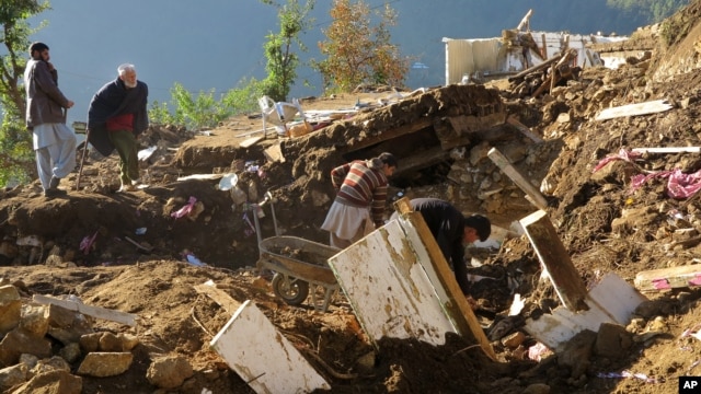
    Pakistani villagers collect their belongings under the rubble of their homes destroyed from an earthquake in Shangla in Swat valley, Pakistan, Oct. 28, 2015.

    http://www.wunderground.com/news/earthquake-afghanistan-pakistan

    Hurricane Olaf Recap

    Olaf moved across the eastern and central Pacific Ocean basins Oct. 14-27, 2015. It did not directly impact land, but did generate high surf that affected Hawaii for several days.
    Here's a recap of Olaf:


    http://www.weather.com/storms/hurricane/news/tropical-depression-nineteen-e-tropical-storm-hurricane-olaf-eastern-pacific

    Cars Trapped In Mud After Rain Brings Flash Flooding To Los Angeles

    LOS ANGELES (AP) — Flash flooding north of Los Angeles sent water and mud flowing into canyons and across roadways Thursday, trapping drivers and closing a stretch of one of the state's main north-south freeways.

    "Due to the drought and fires, all the rain coming down heavily is causing floods," CHP Officer Andrew Mack said. "We have a lot of people up there trapped on the roadway." 

    <span class='image-component__caption' itemprop="caption">This still frame from video provided by KABC-TV shows vehicles stuck in a muddy road in the mountainous community of Lake Hughes, Calif., about 65 miles north of downtown Los Angeles, Thursday, Oct. 15, 2015.</span>

    http://www.huffingtonpost.com/entry/los-angeles-flash-flooding_56205577e4b069b4e1fb9837

    California 2100: More frequent and more severe droughts and floods likely

    A new study suggests that the weather patterns known as El Nino and La Nina could lead to at least a doubling of extreme droughts and floods in California later this century.

    The study shows more frequent extreme events are likely to occur. Other research shows the Golden State's average precipitation increasing gradually, but not enough to account for the occurrence of extreme events. A better understanding of what gives rise to El Nino and La Nina cycles -- together known as El Nino-Southern Oscillation -- might help California predict and prepare for more frequent droughts and floods in the coming century.


    http://www.sciencedaily.com/releases/2015/10/151021161032.htm

    Canada Mountain Experiences Massive Unexplained Landslide

    On Oct. 11, massive amounts of ice and rock came crashing down the southeast flank of the fifth highest mountain in Canada, Mount Steele.

    "‘Normal’ landslides move a horizontal distance that is fairly similar to the height drop, but landslides on top of glaciers often have an elongated runout since the ice surface has low friction,” explained Stark. In this instance, debris fell at a rapid pace for about 0.6 miles and slowed once it hit the glacier’s surface and began sliding northeast. According to Stark and Ekström’s analysis, the maximum speed of the debris was about 30 meters per second.


    http://www.weather.com/science/news/yukon-canada-mount-steele-landslide-avalanche-glacier

    Olaf Weakening After Bringing High Surf to Hawaii

    Olaf Weakening After Bringing High Surf to Hawaii

    Olaf has weakened to a tropical storm over a thousand miles east-northeast of Hawaii. The former hurricane brought high surf to Hawaii the last few days, but that is now subsiding.

    Here is the latest on Olaf:
    • Olaf is located more than 1,000 miles east-northeast of the Big Island of Hawaii.
    • Olaf is moving to the east-northeast and will continue to weaken, becoming a remnant low soon.
    • This storm is not a direct threat to Hawaii or any other land areas.
    • However, high surf generated by Olaf has affected the Hawaiian Islands the last few days, but has now subsided.
    • Last Monday morning, Oct. 19, Olaf strengthened into a major hurricane (Category 3 or stronger), and by Monday afternoon had rapidly intensified to a Category 4 hurricane. Olaf remained a Category 4 until early Wednesday morning, Oct. 21, when it was downgraded to a strong Category 3 hurricane.
    • According to the National Hurricane Center, Olaf was the farthest south forming major hurricane on record in the eastern Pacific basin. Reliable records in that basin began in 1971.
    • Hurricane specialist Eric Blake from the National Hurricane Center says Olaf was the first tropical cyclone on record to track from the eastern Pacific basin (east of 140 degrees W longitude) to the central Pacific basin (west of 140 degrees W longitude), then back to the eastern Pacific basin again.

    Latest Storm Status and Satellite Image

       Forecast Path, Intensity


    Original Article: http://www.wunderground.com/news/tropical-depression-nineteen-e-tropical-storm-hurricane-olaf-eastern-pacific

    Persian Gulf could experience deadly heat

    Detailed climate simulation shows a threshold of survivability could be crossed without mitigation measures


    The research reveals details of a business-as-usual scenario for greenhouse gas emissions, but also shows that curbing emissions could forestall these deadly temperature extremes.

    The study, published in the journal Nature Climate Change, was carried out by Elfatih Eltahir, a professor of civil and environmental engineering at MIT, and Jeremy Pal PhD '01 at Loyola Marymount University. They conclude that conditions in the Persian Gulf region, including its shallow water and intense sun, make it "a specific regional hotspot where climate change, in absence of significant mitigation, is likely to severely impact human habitability in the future."

    That tipping point involves a measurement called the "wet-bulb temperature" that combines temperature and humidity, reflecting conditions the human body could maintain without artificial cooling. That threshold for survival for more than six unprotected hours is 35 degrees Celsius, or about 95 degrees Fahrenheit, according to recently published research. (The equivalent number in the National Weather Service's more commonly used "heat index" would be about 165 F.) This limit was almost reached this summer, at the end of an extreme, weeklong heat wave in the region: On July 31, the wet-bulb temperature in Bandahr Mashrahr, Iran, hit 34.6 C -- just a fraction below the threshold, for an hour or less.

    But the severe danger to human health and life occurs when such temperatures are sustained for several hours, Eltahir says -- which the models show would occur several times in a 30-year period toward the end of the century under the business-as-usual scenario used as a benchmark by the Intergovernmental Panel on Climate Change. The Persian Gulf region is especially vulnerable, the researchers say, because of a combination of low elevations, clear sky, water body that increases heat absorption, and the shallowness of the Persian Gulf itself, which produces high water temperatures that lead to strong evaporation and very high humidity.

    While the other side of the Arabian Peninsula, adjacent to the Red Sea, would see less extreme heat, the projections show that dangerous extremes are also likely there, reaching wet-bulb temperatures of 32 to 34 C. This could be a particular concern, the authors note, because the annual Hajj, or annual Islamic pilgrimage to Mecca -- when as many as 2 million pilgrims take part in rituals that include standing outdoors for a full day of prayer -- sometimes occurs during these hot months.

    Original Article: http://www.sciencedaily.com/releases/2015/10/151026174106.htm

    Tropical Update

    Tropical Update: Atlantic, Pacific Quiet; Watching Indian Ocean


    • There are still three invests in the Indian Ocean, at least one of which, in the Arabian Sea, is likely to further organize & strengthen and could eventually head toward land by this weekend or early next week.
    • The tropics have quieted down elsewhere.

    INDIAN OCEAN

    Land is in play in the path of invests 93B (near Sri Lanka) and 92S (near northern Madagascar) for moisture/rainfall, but neither system is expected to further organize/strengthen much. Whereas, models are adamant that Invest 94A in the central Arabian Sea will crank up. While details of landfall location, should one occur, are uncertain as is always the case so far in advance, all indications are a track in the direction of land.  

    ATLANTIC

    There are no active areas of interest in the Atlantic basin at this time.

    PACIFIC

    Olaf has weakened to a remnant low. High surf is subsiding in Hawaii.
    Eastern Pacific Basin Satellite Image

    Western Pacific Basin Satellite Image
    Original Article: http://www.weather.com/storms/hurricane/news/tropical-update-atlantic-pacific-hurricane-season

    Intensifying Storm to Bring Strong Winds, Heavy Rain and Some Snow to Midwest, East

    Intensifying Storm to Bring Strong Winds, Heavy Rain and Some Snow to Midwest, East

    An intensifying area of low pressure is delivering a trifecta of inclement weather to portions of the Midwest and East through Thursday. Those impacts include strong winds, soaking rainfall that will contribute to commuting hassles, and even a little snow. Strong winds from the storm system have already caused scattered power outages in several states, including parts of western Pennsylvania, southwest New York and Virginia. 

    The main threat of strong winds will be Wednesday and Thursday from two different sources. First, bands of rain and thunderstorms may produce strong wind gusts ahead of a cold front from the Appalachians to much of the Eastern Seaboard from the Carolinas to southern New England. The strong wind gusts over 50 mph may lead to some power outages and downed trees and limbs Wednesday afternoon into Wednesday night. In addition, the pressure gradient around the large-scale low pressure system pivoting into eastern Canada will produce strong winds over a larger area of the Plains, Midwest and Great Lakes Wednesday. Those strong winds will persist in the Great Lakes through Thursday. Most locations will see sustained winds of 20 to 30 mph with higher gusts. However, even stronger winds with gusts in excess of 60 mph are possible along the east and southeast shores of Lakes Erie and Ontario. The National Weather Service has posted high wind warnings for those locations. Tree damage, power outages and lakeshore flooding are possible.Wind advisories and high wind warnings have also been issued in parts of Pennsylvania and New England. Wind gusts up to 60 mph in coastal Maine may lead to power outages and downed tree limbs.
    Steady rainfall, heavy at times, will continue to spread through the Ohio Valley, Great Lakes, Mid-Atlantic and Northeast into early Thursday. Here's an overview of the forecast timing showing when you can expect travel hassles.
    Through Wednesday Night: Most of the Northeast and Mid-Atlantic will be impacted by the rain, which could be heavy at times. This may result in both commuting delays on the roads and at all major airports in the region. Some minor or poor drainage flooding is also possible. The rain may also be accompanied by localized strong wind gusts as mentioned above.
    The powerful low-pressure system will allow some colder air to sweep through the Midwest into Thursday. It's not a noteworthy cold air mass for late October, with high temperatures about 5 to 10 degrees below average in most spots across the region. However, the combination of strong winds and chilly temperatures will produce wind chill values in the 10s and 20s across parts of the Upper Midwest and northern Plains Wednesday night and Thursday morning. However, just enough moisture and cold air may combine to bring snow or a rain-snow mix to parts of the Upper Midwest into early Thursday. Any slushy accumulations should be minor, and confined to elevated or grassy surfaces in North Dakota, Minnesota, Wisconsin and the Upper Peninsula of Michigan.
    Current Radar

    Current Winds

    Wednesday's Thunderstorm Forecast

    Original Article: http://www.wunderground.com/news/eastern-storm-rain-wind-snow


    Halloween Plans May Be Impacted By Wet Weather For Some This Year

    Halloween Plans May Be Impacted By Wet Weather For Some This Year

    An area of low pressure will bring the return of rain to portions of the southern Plains and Lower Mississippi Valley late this week. Flooding may be a concern by Halloween as well, especially in areas that received very heavy rainfall this past weekend.

    Northeast

    High pressure is expected to bring dry conditions and near-average temperatures to the Northeast for most of Halloween weekend. Temperatures will reach the 50s for much of the region with 40s in parts of northern New England and 60s toward the Mid-Atlantic states. Clouds will increase and showers will likely develop in interior sections of the Northeast toward evening and for Halloween night. Temperatures will dip into the 30s by Sunday morning in portions of New England with 40s or low 50s for most of the Northeast.

    South

    The Lower Mississippi Valley, Deep South and northern Gulf Coast will see rain and thunderstorms for Halloween, as a southward dip in the jet stream moves east across the area.
    The rain may be locally heavy at times and flooding may be a concern in areas that are already saturated from the rain this past weekend. A few severe thunderstorms cannot be ruled out.
    Rain may spread as far east as north Georgia and eastern Tennessee by Saturday evening.
    Meanwhile, much of the Southeast coast and Florida will see mainly dry conditions, courtesy of high pressure over the East. Highs will generally be a few degrees within average, ranging from the 80s along the Gulf Coast to the 60s near the Tennessee Valley and the Ozarks.

    Midwest

    An upper-level disturbance may bring light rain to portions of the Great Lakes, middle Mississippi Valley and Ohio Valley during daylight hours on Halloween. Otherwise, the remainder of the region will see a mix of sun and clouds. Temperatures will top out in the 50s and 60s across the area, with a few locations not reaching 50 degrees in northern Minnesota, northern Wisconsin and the Upper Peninsula of Michigan.

    West

    The Pacific Northwest will see rain as a plume of moisture ahead of a cold front soaks the region. High-elevation snow and valley rain are also expected in the northern Rockies. Winds will be quite strong ahead of the Pacific frontal system along the Front Range of the Rockies in Montana and Wyoming. Elsewhere, dry conditions are expected. High temperatures will be near to above average in most areas.
    Halloween Forecast

    Halloween Night Forecast

    Original Article: http://www.wunderground.com/news/halloween-forecast-2015

    Tuesday, October 27, 2015

    How Did Mexico Escape the Strongest Hurricane in Recorded History with No Deaths?

     As Hurricane Patricia drew within miles of the western Mexico coastline, weather forecasters around the world shuttered as they tried to imagine the devastation that was about to take place.
    The strongest hurricane ever observed in either the Atlantic or Eastern Pacific basins was barreling toward a coastline that has struggled with intense storms in the past. Warnings were sent and the coastline was evacuated, but experts still feared a high death toll was inevitable.
    But after the storm passed and officials were able to survey the damage, the Mexican government released its official death toll from Patricia: zero. How were they able to achieve such a massive success in the face of the strongest storm North America has seen since meteorologists began studying hurricanes?
    There were two factors at play: preparedness and luck.
    Certainly, the Mexican government and emergency officials deserve a large amount of praise. According to the Los Angeles Times, tens of thousands of residents and vacationers were evacuated into some 1,200 shelters to prepare for the imminent devastation. 
    It was their only hope to survive: hunker down in the best-built structures along the coast and wait for the beast to pass. Their preparedness was rewarded.
    There was also an element of luck at play. According to Michael Lowry, hurricane specialist at The Weather Channel, the core of Patricia hit a sparsely populated area of the Mexican coastline, not far from several larger cities. Had the storm wobbled a little south or further north, we could be telling a much different story about Patricia right now.


    http://www.wunderground.com/news/hurricane-patricia-mexico-no-deaths

    Olaf Weakening After Bringing High Surf to Hawaii

    Olaf has weakened to a tropical storm over a thousand miles east-northeast of Hawaii. The former hurricane brought high surf to Hawaii the last few days, but that is now subsiding.
    Here is the latest on Olaf:
    • Olaf is located more than 1,000 miles east-northeast of the Big Island of Hawaii.
    • Olaf is moving to the east-northeast and will continue to weaken, becoming a remnant low soon.
    • This storm is not a direct threat to Hawaii or any other land areas.
    • However, high surf generated by Olaf has affected the Hawaiian Islands the last few days, but has now subsided.
    • Last Monday morning, Oct. 19, Olaf strengthened into a major hurricane (Category 3 or stronger), and by Monday afternoon had rapidly intensified to a Category 4 hurricane. Olaf remained a Category 4 until early Wednesday morning, Oct. 21, when it was downgraded to a strong Category 3 hurricane.
    • According to the National Hurricane Center, Olaf was the farthest south forming major hurricane on record in the eastern Pacific basin. Reliable records in that basin began in 1971.
    • Hurricane specialist Eric Blake from the National Hurricane Center says Olaf was the first tropical cyclone on record to track from the eastern Pacific basin (east of 140 degrees W longitude) to the central Pacific basin (west of 140 degrees W longitude), then back to the eastern Pacific basin again.
    http://www.wunderground.com/news/tropical-depression-nineteen-e-tropical-storm-hurricane-olaf-eastern-pacific

    Death Toll Rises to Nearly 340 in Afghanistan, Pakistan Earthquake

    Officials worked Tuesday to reach the hardest-hit remote areas of Pakistan and Afghanistan, one day after a 7.5 magnitude earthquake left at least 339 people dead.
    Afghani and Pakistani officials said 258 of those deaths occurred in Pakistan, while 78 have been confirmed dead in Afghanistan. The temblor was centered deep beneath the Hindu Kush mountains in a sparsely populated region of northeastern Afghanistan that borders Pakistan, Tajikistan and China.
    Rescue crews were working to reach the villages near the epicenter, located 45 miles south of Fayzabad, the capital of Badakhshan province.
    (MORE: Flooding Swamps Texas; Homeless Man Found Alive)

    In Pakistan, the Swat Valley and areas around Dir, Malakand and Shangla towns in the mountains of Khyber Pakhtunkhwa province were also hard-hit. Officials said 202 of the dead were killed in Khyber Pakhtunkhwa.
    The Pakistani town closest to the epicenter is Chitral, while on the Afghan side it is the Jurm district of Badakhshan.
    More than 2,000 people were injured in Monday's temblor, which also damaged more than 4,000 homes in Pakistan, officials said.
    In Afghanistan, Qameruddin Sediqi, an adviser to the public health minister confirmed 78 dead and 466 wounded, based on numbers reported by hospitals across the country.
    "We believe the exact numbers are much higher because not all people bring the bodies to the hospitals so there are many that are not being counted. And there are still areas we don't have access to so we are not aware of the situation there," he said.
    Badakhshan Gov. Shah Waliullah Adeeb said more than 1,500 houses there were either destroyed or partially destroyed.

    http://www.wunderground.com/news/earthquake-afghanistan-pakistan

    Homes Damaged From Highest Tides in Decades Along Parts of Georgia, South Carolina

    Persistent onshore winds coupled with the monthly spring tides led to the highest tides in decades Tuesday morning along the South Carolina and Georgia coasts, driving coastal flooding into Charleston, South Carolina, among other areas.
    Enlarge

    Flooding in Charleston, South Carolina, during the morning high tide on October 27, 2015.  (Steve Petyerak/The Weather Channel)
      Enlarge

      High tide, third highest on record, set Tuesday morning in Charleston, South Carolina, on October 27, 2015.   (NOAA)

      http://www.weather.com/storms/severe/news/charleston-south-carolina-georgia-coastal-flooding
        At least 20 homes, including two businesses, were damaged by the high water at Edisto Beach, South Carolina, according to a local storm report from the National Weather Service.
        Coastal flooding closed several streets and intersections on the Charleston peninsula Tuesday morning, according to the Charleston Police Department
        Tide levels at Charleston's harbor topped out at 8.686 feet above mean lower low water level, the location's fourth highest tide on record, dating to 1921.
        Only three events produced higher tides at Charleston Harbor: Hugo on Sep. 21, 1989 (12.56 feet), an August 11, 1940 hurricane (10.27 feet) and a New Year's Day 1987 coastal storm (8.84 feet) produced higher tides at Charleston Harbor. 
        Tuesday's tide level was 4-5 inches higher than the peak measured during the historic South Carolina flooding and coastal flooding event earlier in October. Fortunately this time, there wasn't 17-27 inches of rainfall occurring at the same time.

        A Few Severe Thunderstorms With Damaging Winds Possible in the East Wednesday (FORECAST)


         Severe thunderstorms are not expected on Tuesday. However, the risk of isolated severe thunderstorms will return on Wednesday as a cold front slices into the East.
        Locally heavy rain will be a concern through midweek and strong wind gusts will be a threat as well, especially in the Great Lakes region.
        We have the latest severe threat forecasts and radar maps including watches and warnings below.

        Tuesday

        • Severe thunderstorms are not currently anticipated. Otherwise, locally heavy rain may cause spotty flooding in the Tennessee Valley and Deep South. 

        Wednesday

        • Bands of rain and thunderstorms may produce strong wind gusts ahead of a cold front from the Appalachians and Upper Ohio Valley to much of the eastern seaboard from the Carolinas to southern New England Wednesday and Wednesday night.
        • These strong winds gusts may lead to some power outages and downed trees, tree limbs.
        • Strong non-thunderstorm wind gusts are also expected behind the cold front in the Great Lakes region.

        Thursday

        • Severe thunderstorms are not expected. Wind gusts will remain strong near in the Great Lakes region all day and in parts of coastal New England early in the day.
        • Thunderstorms should increase later in the day in parts of the Desert Southwest, with some small hail and heavy rain possible.
        http://www.weather.com/storms/tornado/news/severe-weather-tracker-page

        Heavy Rain Caused Flooding in Texas and Along the Gulf Coast

        An upper-level low pressure system and an area of low pressure slide east along the Gulf Coast and combined to deliver the drenching downpours. The surface low pressure system in the Gulf of Mexico formed partially in response to the mid- and upper-level remnants of Hurricane Patricia. Also involved is the leftover moisture from Patricia.

        This setup resulted in flooding along parts of the Texas Gulf Coast, including the Houston metro area, on Saturday. Many roadways and vehicles were reported to be under water around Houston Saturday night. Other parts of Texas have also seen flooding in recent days, with localized rainfall totals of more than one foot. Corsicana, Texas, has already received more than 20 inches of rain since Thursday, causing serious flash flooding.
        New Orleans International Airport recorded 8.67 inches of rain on Sunday, making it the fourth wettest calendar day on record there dating to 1946.
        On Monday, the heavy rain moved farther east with more than 4 inches of rain reported in Mobile, Alabama and Pensacola, Florida

        http://www.weather.com/forecast/regional/news/patricia-gulf-coast-lower-mississippi-valley-flooding

        Monday, October 26, 2015

        The official death count from the strongest hurricane ever measured in the Western Hemisphere: zero.


        Two days after Hurricane Patricia made landfall, packing winds of 165 mph, the toll appears to be limited to flooding and wind damage to houses, power outages and small mudslides that briefly blocked some roadways.

        For the Mexican government of President Enrique Peña Nieto, it was a rare bit of good news in a year in which it has sometimes seemed that everything that could go wrong, did. Peña Nieto has been hammered by criticism over his handling of the disappearance of 43 college students and the prison escape of drug cartel leader Joaquin “El Chapo” Guzman, and his administration has been beset by corruption scandals.

        But this time, Mexico — and Peña Nieto — benefited from what appears to have been a successful emergency response and extraordinary good luck. Patricia, at one point the strongest hurricane ever measured in the Western Hemisphere, struck land in a relatively remote stretch of Mexico’s Pacific coast and quickly petered out as it hit the coastal mountains.

        Source: http://www.latimes.com/world/mexico-americas/la-fg-mexico-patricia-manzanillo-20151025-story.html

        Another Flood Threat Might Be Brewing for the South-Central States

        One of the hardest hit areas was Corsicana, Texas, which saw more than 20 inches of rain late last week into the weekend. With the recent rains, Dallas-Fort Worth International Airport has now seen 46.64 inches of rain in 2015, making it the seventh wettest year on record there.

        A southward dip in the jet stream will move from the West into the southern Plains late this week into the weekend.

        As the storm system moves east, heavy rain may once again impact parts of the southern Plains and lower Mississippi Valley Friday through this weekend, including Texas, Oklahoma, Arkansas and Louisiana.

        Depending on how this weather system evolves, we could see multiple rounds of rain across the same areas. Of course, that scenario would lead to the potential for more flooding. Conversely, if the weather system moves along progressively, that would reduce the threat of flooding.

        Source: http://www.wunderground.com/news/three-weather-stories-eastern-rain-wind-south-flooding

        Severe Storms Cause Power Outages in New Orleans


        Screen Shot 2015-10-25 at 10.18.21 PM.png

        The heavy rains and storm gusts moving through the New Orleans area late Sunday (Oct. 25) are causing power outages throughout the region, and restoration crews are out working to restore service while contending with the severe weather conditions.

        According to Entergy's Louisiana power outage map, more than 22,800 customers were without power as of 10:30 p.m. Sunday. The larger concentrations locally were in the 7th Ward, Lakeview, Meraux, Timberlane and near Estelle.


        http://www.nola.com/weather/index.ssf/2015/10/power_outages_accompany_severe.html