Monday, August 31, 2015

Hurricane Fred

Hurricane conditions will spread from northeastern Cabo Verde to the northern and northwestern islands through Monday night and into early Tuesday. Hurricane-force winds extend out 15 miles from the center of Fred.
Rainfall accumulations of 4 to 6 inches are likely with up to 10 inches possible in spots, which could trigger life-threatening flash flooding and mudslides. Coastal flooding is an additional concern in areas of onshore winds. 
After passing through Cabo Verde Islands, Fred will turn west-northwestward over the open Atlantic Ocean. Southwesterly winds aloft, stable air and cooler water temperatures should begin to weaken Fred later in the week.
There is no indication at this time that Fred will come anywhere near the Caribbean or North America based on the latest computer model guidance and the state of the atmosphere. In fact, Fred is forecast to weaken to a tropical depression and then a remnant low in about 4-5 days.


http://www.weather.com/storms/hurricane/news/tropical-storm-hurricane-fred-atlantic-2015

map_tropinfo06_ltst_5nhato_enus_650x366.jpg

California Water Cuts

Evidence of strict conservation efforts strikes the eye when driving through Palm Springs, a desert city in Southern California popular with tourists since the early 1900s. Known as California’s Desert Oasis, the city’s once lush green grass is now a moribund yellow and brown. Certain fountains that flowed for decades with endless streams of water have been shut off. And residents have been made aware that they could face fines if they consume too much water.
In April, Gov. Jerry Brown mandated that the Coachella Valley’s three local water providers, which service Palm Springs and the surrounding area, cut their consumption by 36 percent - the highest reduction rate across the state. At times over the past year, Palm Springs has consumed two to three times the average amount of water as the rest of the state. But on Thursday, members of the State Water Resources Control Board announced the Desert Water Agency, headquartered in Palm Springs, had reduced its consumption by 35 percent.


http://www.foxnews.com/politics/2015/08/28/california-cuts-water-use-amid-drought/


Can Erika Quench Three Separate Droughts?

Tropical Storm Erika has fizzled, but one impact somewhat regardless of intensity is its potential for heavy rain.
Torrential rain over the mountainous island of Dominica proved deadly and destructive Thursday, and over 24 inches of rain soaked parts of the southern Dominican Republic Friday night.
A recently published study examining a 58-year period found that, contrary to conventional wisdom, tropical cyclones really don't help Southeast U.S. droughts
Despite that, Erika's remnant rain, if not triggering flash flooding, would at least be a welcome sight in three separate drought areas.

http://www.weather.com/storms/hurricane/news/erika-puerto-rico-florida-carolinas-drought-relief

Warm Pacific = Extreme El Niños

Warming Pacific Means Extreme El Niños Could Hit Twice As Often


The most intense El Niño events may soon hit every 10 years, instead of every 20 years, thanks to warming water in the eastern Pacific Ocean, a new study predicts.
An El Niño is the warm phase of a long-standing natural climate cycle in the Pacific Ocean. When changing wind patterns start piling up warm water in the eastern part of the equatorial Pacific, the redistribution of hotter water triggers changes in atmospheric circulation that influences rainfall and storm patterns around the world — an El Niño.
During extreme El Niños, sea surface temperatures warmer than 82 degrees Fahrenheit (28 degrees Celsius) develop in the normally cold and dry eastern equatorial Pacific Ocean.

http://www.weather.com/science/environment/news/extreme-el-ninos-could-hit-twice-often-20140120


CLIMATE SHIFT


2


As we know, our earth atmosphere is melting away. Earth temperatures are warming as sea level rises. Above left picture is the Alaskan Muir Glacier taken on August 13, 1941; above right is taken from the same vantage point on August 31, 2004.

The two pictures is a result of CO2 and many other fossil fuel gases that are being abused in our Earths atmosphere. It only took approximately 63 years to cause this "melt down". That's how long it takes a tree to fully mature! The melting of sea glacier causes sea levels to rise and like a domino affect; it shifts the sea temperature causing other natural disasters such as hurricanes.

But what it really boils down to, are these disasters natural like we believe they ought to be? Or are we causing the disasters?

"Taken as a whole, these changes provide compelling evidence that increasing temperatures are affecting both ecosystems and human society." - Our Changing Climate


Written by: Brittany F. Smith
August 31, 2015


Sunday, August 30, 2015

Pacific Trio

Rare Trio of Hurricanes over the Pacific Ocean 


As common as hurricanes are it is not common to have multiple in one place. This Saturday, 8/29/15, there were three category four hurricanes in the pacific ocean for the first time in history. Hurricane Kilo had the speed of 135 mph, Hurricane Ignacio and Hurricane Jimena both had speeds of 140 mph. Category four hurricanes are classified as storms with the maximum winds of 130-156 mph. This rare weather event is credited to El Nino; a common and rather unknown warming of the central and eastern pacific ocean. When El Nino occurs wind shear is diminished allowing for these storms to form with more ease than with usual weather conditions. These storms stayed category four storms until Sunday, 8/30/15, at 5pm when Kilo and Ignacio diminished into category three hurricanes. Even though Hurricane Ignacio has been lowered to a category three hurricane it is still threatening Hawaii.


Three Category 4 hurricanes on Sunday morning in the Pacific Ocean, Kilo (left), Ignacio (center), and Jimena (right).

http://www.weather.com/storms/hurricane/news/three-category-4-hurricanes-pacific-kilo-ignacio-jimena

Typhoon Soudelor Kills 6 in Taiwan and Leaves Millions Without Power

http://www.nytimes.com/2015/08/09/world/asia/typhoon-soudelor-kills-6-in-taiwan-and-leaves-millions-without-power.html?ref=topics


The center of the typhoon left Taiwan’s western shore by 11 a.m. Saturday, as the storm headed west toward the Chinese province of Fujian, weakening as it went. Tropical Storm Risk, a British weather company, said the storm was a Category 3 typhoon when it made landfall in Taiwan, dropped to Category 2 by midday and was Category 1 when it reached Fujian late Saturday, with maximum sustained winds under 95 m.p.h........

Weather Pattern Change: Heat Wave Ahead in Chicago

Last week, in North America, the jet stream dipped south across the East, which brought cooler temperatures to the East, Midwest, and even deep South.States in these areas experienced below-average and record low temperatures for the month.  The temperature in Chicago didn't rise above 75 degrees, which was particularly below average. Arkansas's temperatures got as low as 49 degrees on last Tuesday. But all of that is soon to change.


The jet stream has lifted in the Midwest and East, and is dipping south across the West. Therefore, the Midwest and East will experience a heat wave the week of August 30, 2015, with temperatures climbing back up to the 90s. In Chicago and New York City it is expected to be in the upper 80s, around five to ten degrees above average. 


However this jet stream shift brings good news to the West, which is surviving one of the hottest summers on record. Most of Washington and Oregon experienced temperatures in the upper 80s and 90s this month. This hot and dry weather has caused wildfires to spread across the Northwest. By the jet stream dipping south across the West, the temperatures will drop down to the 70s and most of the states should receive some rainfall and heavy winds.

First Winter Storm Warning of 2015 Issued for Northern Alaska

The calendar may still say August, but the first winter storm warning was issued this past Wednesday in the U.S. and you guessed it – the warning was in far northern Alaska. In addition to the snow, coastal flooding was reported in Barrow, Alaska.
There was snow last week in Glacier National Park, but winter storm warnings were not issued. Temperatures dipped into the 30s into much of northern Montana, including Cut Bank, where the low hit 32 degrees Aug. 23.
Now, at the end of August, a winter storm warning had been issued for the northeastern Brooks Range above 2,500 feet in northern Alaska. While snowfall totals were generally light, it was enough to dust some of the higher peaks. All winter weather advisories and warnings have since been canceled.

Snowfall Forecast


Information from: http://www.wunderground.com/news/first-winter-storm-warning-2015-16-alaska

Erika weakens

Erika Weakens, Quiet Weather Locally


As of 9:30 this morning, Erika weakened to a remnant low. However the remnants of Erika will still produce heavy rain across Cuba, the Bahamas and southern Florida tonight. So, there is a chance Erika could strengthen back into a tropical storm if it stays over water. Plus the wind shear is forecast to decrease across the Gulf over the next few days, so that could help Erika get stronger as well. Regardless of whether Erika turns back into a tropical storm or not, it is still going to bring between 3-5 inches of rain and gusty winds to the southern and western parts of Florida over the next few days. Some of the leftover tropical moisture from Erika could move into Hampton Roads by the end of the work week in the form of rain. So we have put a chance for showers and storms in the forecast Thursday and Friday.

Godzilla

Godzilla' weather pattern may hit California in fall, winter


In 1998, the Times noted, the region saw so much rain so quickly that widespread flooding and mudslides killed 17 people and caused more than half a billion dollars in damage. Downtown Los Angeles got nearly a year's worth of rain in February alone.
Mike Halpert of the National Oceanic and Atmospheric Administration's Climate Prediction Center warned that one season of above-normal rain and snow "is very unlikely to erase four years of drought," KTLA reported.
State climatologist Michael Anderson agreed, saying in a statement that California "cannot count on potential El Niño conditions to halt or reverse drought conditions." Historical weather data show that there's a 50% chance at best of California seeing a wetter winter. "Unfortunately, due to shifting climate patterns, we cannot even be that sure," he said.
http://www.usatoday.com/story/news/2015/08/13/godzilla-el-nino/31647757/


88 Homes Evacuated in New Mexico


"Surging floodwaters prompted authorities in Carlsbad, New Mexico, to urge residents to evacuate their homes early Monday morning.
According to Emergency Center spokesman Kenny Rayroux, crews went door-to-door in the James Street area urging residents of 88 homes to evacuate. People in another 30 homes along Fiesta Street were told to be ready to leave, if necessary. "

http://www.weather.com/storms/severe/news/carlsbad-new-mexico-flooding-20140922

Saturday, August 29, 2015

Washington Wildfire

http://www.weather.com/safety/wildfires/news/western-wildfires-latest-news 
The largest wildfire in Washington state history grew by another 22 square miles on Friday, and fire officials worried that high winds over the weekend would only make the situation worse.
At least 472 square miles of land have been burned by the Okanogan fires, which were only 23 percent contained Saturday afternoon.The wind-whipped and drought-fueled fire has destroyed at least 45 homes, 49 cabins and 60 outbuildings, and three firefighters have died battling the blaze. A memorial service was planned Sunday in Wenatchee.
Fire spokeswoman Sierra Hellstrom said temperatures were lower and humidity higher on Friday — conditions expected to slow the fire.However, lightning and high winds predicted for the weekend could spread the flames, she said.The fire was just five miles from merging with a 281-square-mile wildfire north of Nespelem, Hellstrom said.
Meanwhile, a wildfire burning in Stevens County north of Spokane grew almost 15 square miles overnight after jumping a containment line and stood at 87 square miles. That fire was about 25 percent contained.
"The winds, terrain and vegetation have created the potential for large growth," fire officials said in a press release.
With wind gusts expected to reach 20 mph, firefighters were concerned the blaze could threaten homes.
Meanwhile, high fire danger prompted the U.S. Forest Service to close an area north of Highway 2 that includes a major portion of the Okanogan-Wenatchee National Forest from f the Columbia River to the crest of the Cascade Range.
All the fires burning in eastern Washington were hurting air quality. Readings were hazardous in Republic, Omak and Nespelem, and unhealthy in Colville, Wellpinit and Davenport.
More than 7.7 million acres have burned in wildfires this year, according to the National Interagency Fire Center. That's well above the 10-year average of about 5.4 million acres through Aug. 28.
There are currently dozens of large wildfires burning across the West; here's an update on a few of them.

Course of Deadly Tropical Storm Erika Puzzles Forecasters

http://www.nbcnews.com/news/weather/course-deadly-tropical-storm-erika-puzzles-forecasters-n417386

    Forecasters and emergency agencies prepped for a long weekend early Friday as Tropical Storm Erika wobbled toward Puerto Rico and then the southern Atlantic coast, where it could be a hurricane when it arrives early next week. A tropical storm warning was in effect for Puerto Rico and the U.S. Virgin Islands after Erika caused mudslides blamed for at least four deaths on the Caribbean island of Dominica. More than 12 inches of rain poured down on Dominica in less than 12 hours, the National Weather Service said — and it could do close to the same overnight and Friday on Puerto Rico, where forecasters warned that major flooding is possible. After that, it's anybody's guess.
    The center of Erika started "wobbling" Thursday, according to the weather service, making it difficult to project its course. The storm was about 135 miles south east of San Juan, Puerto Rico, at 11 p.m. Thursday night with maximum sustained winds of 45 mph, the National Hurricane Center said. Late Thursday afternoon, forecasters said Erika looked increasingly likely to reach the U.S. mainland Monday night or Tuesday morning, possibly as a Category 1 hurricane.
   TODAY (Aug. 28, 2015) weather anchor Al Roker said coastal areas were likely to get 5 to 7 inches of rain by next week — with some getting as much as a foot."

"It's been 10 years since Florida had a significant hurricane, and this one could be the one," Roker said Thursday evening.

Embedded image permalink

Watch Issued for Hawaii

Highlights:

  • Hurricane Ignacio is located roughly 525 miles east-southeast of Hilo, Hawaii Saturday afternoon, EDT.
  • Hurricane Ignacio strengthened to a Category 3 hurricane Saturday. Slow weakening is forecast by Sunday.
  • Ignacio is not a threat to land this weekend, but may come close to Hawaii as early as Monday Tuesday.
  • A tropical storm watcis in effect for the Big Island of Hawaii.
  • Interests in the Hawaiian Islands should monitor the progress of this latest hurricane.
Latest Storm Information
Enlarge
Latest Storm Information
    Ignacio Watches/Warnings
    Enlarge
    Ignacio Watches/Warnings
    Watches mean conditions are possible within 48 hours. Warnings mean conditions are expected within 36 hours.


      Ignacio continues to strengthen in a favorable environment for tropical cyclone, just over 500 miles east-southeast of the Big Island of Hawaii. Wind shear remains somewhat low and ocean temperatures are still warm. Ignacio is likely to remain a major hurricane for at least the next 12 to 24 hours. 
      Later this weekend, however, conditions are expected to become less favorable, with an increase in wind shear and slightly cooler water temperatures, so a weakening trend is likely as it approaches the Hawaiian Islands.
      The increase in wind shear is thanks to the proximity of the subtropical jet over the Hawaiian Islands. As Ignacio gains latitude, it will likely face increased shear, which tends to push convection away from the center of tropical cyclones.
      http://www.weather.com/storms/hurricane/news/tropical-storm-ignacio-hurricane-eastern-pacific-hawaii-august-2015


      Major Pattern Change Coming to U.S.

      Pattern Change Overview

      Jet Stream Pattern
      Enlarge
      Jet Stream Pattern
      The forecast jet stream pattern on Sunday.
        The key to this pattern change is the rearrangement of the jet stream across North America. The jet stream is a ribbon of fast winds aloft in the upper atmosphere that helps dictate the weather conditions we see near the surface of the earth.
        Right now, the jet stream is dipping south across the eastern half of the United States. This has brought a cooler, refreshing air mass to parts of the Midwest, East and even the Deep South. Through this weekend, the main ribbon of strong winds associated with the jet stream will build north into Canada, though there will be some lagging upper-level energy in the East south of the main jet stream. The end result is building warmth across the nation's midsection and points east.
        At the same time, the jet stream will buckle southward along the West Coast in response to its northward shift in the East. This will bring much cooler air and the potential for some welcome rainfall to the Pacific Northwest.
        The pattern change may also play a role in helping to steer the latest Atlantic named storm, Erika. However this will depend on Erika's future path and intensity. For more on that story, click here
        http://www.weather.com/forecast/national/news/pattern-change-late-august-early-september-northwest-midwest-east

        The Details of Hurricane Ignacio

        On Saturday morning Hurricane Ignacio was declared a category three storm, however it is expected to weaken over the weekend. While the storm is located 600 miles southeast of Hilo, Hawaii and currently no threat to land, a tropical storm watch has been implemented for the Big Islands of Hawaii. The storm is currently strengthening due to the relativltey low winds and warm ocean temperatures. However conditions are expected to become less favorable as the wind shear increases and the ocean temperatures become cooler. The change in conditions will causes the hurricane to become weaker. The increase in wind shear is thanks to the proximity of the subtropical jet over the Hawaiian Islands. As Ignacio gains latitude, it will likely face increased shear, which tends to push convection away from the center of tropical cyclones.

        The picture to the left displays the current projected path of the storm. The picture on the right represents the latest details of the storm. 


        Original article: http://www.wunderground.com/news/tropical-storm-ignacio-hurricane-eastern-pacific-hawaii-august-2015

        The Development of Hurricane Kilo


         The article discussed the development of Hurricane Kilo and the path it is taking across the central Pacific Ocean. While Hurricane Kilo was initially in route of hitting Hawaii, the storm's course has changed and is now headed northwest toward the International Dateline. While the hurricane is strengthening, it is believed that the storm will not pose a direct threat to land. Instead, the hurricane is continuing to move northwest over open waters. If the storm were to cross the International Dateline, it would be renamed "Typhoon Kilo."

        The picture to the left shows a satellite image of the storm along with details regarding it's strength and location. The picture on the right shows the current intended path of the storm, confirming it is moving towards open waters.
          
        While Hawaii has been cleared from the direct path of the storm, the islands are still suffering the effects from it. The state has experienced heavy rainfall and thunderstorms. The excessive rainfall has caused flooding and road closures throughout the area. The thunderstorms have produced over 10,000 cloud to ground lightening strikes in a 24 hour period. There is still currently a flood warning issued in the effected areas. 

        Original article: http://www.wunderground.com/news/tropical-depression-three-c-tropical-storm-hurricane-kilo-pacific-hawaii-2015

        Friday, August 28, 2015

        Thunderstorms Soak Chile Desert in Years of Rain and Kill at Least 9 Thor Hicks II

        Thunderstorms brought the equivalent of 7 years of rain to Chile's Atacama desert region and caused deadly flooding Thursday. 
        Antofagasta, Chile, where the annual average precipitation is 0.13 inches, saw 0.9 inches of rain in 12 hours.
        "The Atacama Desert is an extremely arid region and has been for millions of years. As a result, the terrain is hard and rocky because rainfall isn't frequent or abundant enough for either weathering rocks into sand or supporting the kind of ecosystem that would help turn rocks and minerals into soil. Without soil and plant cover to help absorb rainfall, it just runs off instantly as torrents of water," weather.com senior meteorologist Nick Wiltgen said. 
        These torrential rains caused the Copiapo River in northern Chile to overflow and kill at least nine people, while simultaneously knocking out power, making roadways impassable and leaving 19 people missing. 
        Thousands evacuated after officials warned of mudslides in the normally-parched region. 
        Chile's Deputy Interior Minister Mahmud Aleuy called the flooding "the worst rain disaster to fall on the north in 80 years." 
        TV images showed brown, muddy waters flooding the streets and reaching a hospital in Copiapo city. Some people living along the river had to be rescued by helicopter because roads were blocked by water and mud. TV footage showed several families waiting on the roofs of their homes, including a man who had punched a hole through his roof to save his toddler.
        At least seven people have been killed and 19 people were listed as missing in three communities hit by flooding, officials said.
        Desperate family members of the victims took to Twitter pleading for help in finding their loved ones.
        The government declared a state of emergency, putting the region under military control, and President Michelle Bachelet flew to the area Wednesday evening to observe the problems first hand.
        "We're living an extremely difficult situation," she said. "The previous forecast was that there was a huge drought here, so the rains were not necessarily seen as a catastrophe. Foreseeing was really difficult because no one knew."
        Aleuy said that military helicopters were flying in supplies to areas cut off by the rains. 
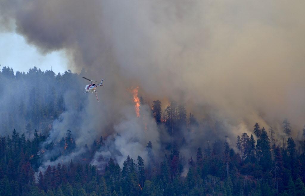
        The heavy rains came after several days of high temperatures and a drought that stoked raging wildfires in Chile's south-central regions. The fires have burned nearly 93,000 hectares in the 2014-2015 season, far above the annual average of 59,300 over the previous five years.
        Earthquake-prone Chile is no stranger to the forces of nature. The national geological service Sernageomin said residents should be on alert due to increased activity at the Villarica Volcano in the country's south, which erupted on March 3, forcing evacuations and disrupting air traffic.
        The storms prompted Chile's state-run copper giant Codelco to suspend work due to blocked roads, but the company said Thursday it was reopening sites in the north, including some of the world's largest copper mines


        y The Associated Press

        Four Tropical Cyclones At Once : How Rare Is It? Thor Hicks II

        The strongest of these is Cyclone Pam, whose maximum sustained estimated winds had topped 165 mph as it slammed the Republic of Vanuatu Friday night and Saturday morning, local time.
        Meanwhile, Cyclone Olwyn made landfall in far western Australia, Cyclone Nathan made a U-turn in the Coral Sea north of Cairns, Australia and, finally, Tropical Storm Bavi is spinning well east of Guam in the western Pacific Ocean.
        Wind field analyses also picked out the four circulations well. You could trace wind streamlines coming from the western side of Tropical Storm Bavi eventually feeding into the eastern side of much stronger Cyclone Pam. The centers of Bavi and Pam were about 1,600 miles apart, at that time. (Remember winds flow clockwise around low-pressure systems, such as tropical cyclones, in the Southern Hemisphere).


        By Jon Erdman
        Published Aug 26 2015

        Tropical Storm Erika causes major damage and at least 12 fatalities on the small island of Dominica.

        About 20 others remain missing on the tiny Lesser Antilles island that's home to about 72,000, and many homes have been destroyed in the storm, the AP also reported.
        "The situation is grim. It is dangerous," Ian Pinard, Dominica's communications minister, told the AP.
        About 80 percent of the island was left without electricity, and the water supply was cut off. Trees and light poles were strewn across streets, and several buildings sustained damage, including torn off scaffolding. AP also reports the main airport was closed because of flooding, with water rushing over at least one small plane."The capital city is a wreck. It is a sight to behold. It's a disaster," policewoman Teesha Alfred told the AP about Roseau.

        Main story: http://www.wunderground.com/news/tropical-storm-erika-preparations-caribbean-florida-impacts

        Wednesday, August 26, 2015

        Tropical Storm Ignacio Gets Stronger.

        "Ignacio continues to gather strength in a favorable environment for intensification about half way between Los Cabos, Mexico and Hilo, Hawaii.

        The airmass that the storm is moving through has relatively low wind shear, or the change in wind speed with height. When wind shear is too significant, it can effectively rip apart the structure of a tropical cyclone. With limited wind shear in the storm's path, Ignacio should continue to get better organized over the next few days as it eventually turns west-northwest."


        map_tropinfo12_ltst_5nhpao_enus_485x273.jpg


        http://www.wunderground.com/news/tropical-storm-ignacio-hurricane-eastern-pacific-hawaii-august-2015

        Tuesday, August 25, 2015

        Trouble In The Edens- Ivanna


        Tropical Storm Erika Approaching the Leeward Islands; Potential Threat to Puerto Rico, Virgin Islands, Hispanola, Bahamas


        Tropical Storm Erika is currently centered just under 500 miles east of the Lesser Antilles and is moving quickly westward at 18 mph. 
        For the next couple of days, Erika will be moving into an environment with some vertical wind shear, some dry air, both general inhibitors for tropical cyclone intensification.
        Erika may face a lower magnitude of wind shear and dry than did the former Hurricane Danny, but these negative factors, plus a potential future track over land in the Caribbean complicate both the intensity and track forecasts.
        The tropical storm was clearly struggling Tuesday night as Air Force hurricane hunter data suggested that the low-level center of Erika remained exposed to the north of limited convection. Also, the central pressure rose to 1006mb at 11 p.m. EDT Tuesday, a sign that the storm is having difficulty better organizing.
        http://www.weather.com/storms/hurricane/news/tropical-storm-hurricane-erika-atlantic-august-2015


        Western Wildfires

        Currently in Washington state, there is a wildfire that has spread to about three times the size of Seattle. As of this evening, only ten percent of the fire has been contained. The fire is still spreading and is anticipated to burn for several more months. So far, three firefighters have lost their lives fighting this wildfire and four have been injured.

        Most states in the west experiencing these wildfires are recruiting volunteers, former firefighters, and construction workers. This year alone, 7.5 million acres have burned as a result of wildfires; which is about 2 million acres more than the average for this decade. Most of the wildfires are occurring in Idaho, with 17 wildfires currently burning. In Oregon, a wildfire has destroyed more than 36 homes, burned about 114 square miles, and it has only been 30 percent contained.

        I am wondering what impact these wildfires have on our environment, considering the smoke and fumes that they release and the vast number of environmental resources they consume?

        Embedded image permalink
         (this is a photo of a wildfire that broke out on August 24, 2015, photo courtesy of Andrius Baskys)
        Western Wildfire Article