Wednesday, April 30, 2014

Torrential Rain Hits Florida Panhandle


Tuesday night into Wednesday morning, Alabama's Gulf Coast and the Florida pandhandle were hit with torrential rain that caused widespread flooding. As much as 15 to 20 inches of rain fell on the Panhandle over a 24-hour period, and there was plenty of photo documentation. 


Twisters Past and Present: Interactive Tornado Tracker


The heart of the tornado season is upon us, with twisters touching down in parts of the U.S. nearly every week through mid-summer. The 2012 tornado season is already off to a busy start, but fortunately not on the scale of last year’s deadly season.
The 2011 tornado season was the deadliest since modern record keeping began in 1950, as 550 people were killed and about 5,400 injured, many of them during large-scale outbreaks in the Southeastern states. One tornado, an EF-5 monster, became the fourth-deadliest tornado in U.S. history and the most expensive tornado on record when it tore through Joplin, Mo., on May 24.
Now, using Climate Central’s new interactive tornado tracker, you can track tornado reports for this season and investigate reports during past years.
Using the tracker, you can look back at one of the largest tornado outbreaks in U.S. history, which took place last year on April 25-28. Or you can examine one of the big events this season so far, which took place on March 2-3.
The tracker plots tornado reports from NOAA's Storm Prediction Center in Norman, Okla., and is updated multiple times a day to capture breaking events. Keep in mind, though, that this tracker shows reported tornadoes, not confirmed tornadoes. The National Weather Service conducts damage assessment surveys after tornadoes are reported to determine if a tornado actually touched down, and if so, how powerful it was.
The number of tornado reports is typically greater than the number of actual tornadoes, since multiple reports can come in from storm spotters, all reporting the same single tornado at different points along its path.

To access the interactive map and view the entire article, click here:  http://www.climatecentral.org/blogs/twisters-past-and-present-interactive-tornado-tracker

Tornado Technology Innovation Born From 1974 Tragedy


Thursday marked the 40th anniversary of one of the most destructive tornado outbreaks in U.S. history. The event, deemed a Super Outbreak, took place over two days and spawned nearly 150 tornadoes across 13 states and the Canadian province of Ontario. The storm left behind millions of dollars in damage and caused 300 deaths and 6,000 injuries. The only outbreak with more tornadoes occurred in late April 2011.

The map above shows the meticulous detail that went into analyzing the 1974 Super Outbreak by Ted Fujita, who devised the Fujita Scale to quantify the strength of tornadoes. Without computers, Fujita had to hand draw each tornado track and width after doing extensive aerial surveys. The National Weather Service's Wilmington office has a large version well worth looking at if you don't mind the load time.

As shocking as the geographic scope of the outbreak is the number of intense tornadoes it spawned. Of the 148 tornadoes that touched down, 30 were rated F4 or F5, the two most destructive categories. According to U.S. Tornadoes, the U.S. only sees 7 such tornadoes per year, underscoring just how violent the outbreak was.
There was a small silver lining in the aftermath, outlined in a story by the University Corporation for Atmospheric Research’s Bob Henson. During his aerial surveys, Fujita discovered a previously unknown weather phenomenon. Among the wreckage, he noticed not all the damage was consistent with tornado winds, which tend to swirl. Instead, there were areas that were flattened like a rolling pin had gone wild. Further research of this and other similar events found previously unidentified microbursts -- intense downward pulses of air that can disrupt air travel in addition to flattening trees and homes -- as the culprit.
The results have led to aviation safety improvements. “It’s likely that hundreds of deaths have been avoided thanks to Ted Fujita’s uncommon insight, his exhaustive documentation, and the careful field work carried out by NCAR scientists and their collaborators,” Henson wrote.
Tornado prediction has also dramatically improved. To illustrate some of those advancements, the Storm Prediction Center used observations of conditions that preceded the 1974 storm and ran computer models on Wednesday to see how well they could forecast the outbreak if it happened today. It turns out the models were able to identify conditions that were conducive for tornadoes to develop in a number of locations where twisters did touch down in 1974.
That forecast skill come from decades of technological upgrades since the Super Outbreak, including Doppler radar technology and powerful computers  that can crunch exponentially more calculations than their 1974 brethren. And those upgrades are extremely helpful on a day like Thursday when nearly 52 million people are at risk from severe weather according to the National Oceanic and Atmospheric Administration.

Despite Spate of Tornadoes, 2014 on Track for Low Total


Even with the deadly spate of tornadoes spawned this weekend, 2014 is still on pace to see one of the lowest recorded counts for a tornado season, scientists say. That it comes on the heels of one of the busiest seasons on records just a few years earlier is part of a trend in extreme variability that researchers are examining in an effort to determine the cause, including the potential influence of climate change. 

The string of recent tornadoes that stretched from Arkansas to Georgia marked the end to a streak of 159 days without a tornado ranking an EF3 or higher on the Enhanced Fujita scale (which goes from 0 to 5). And after cataloging only 93 tornado reports through April 24, the National Weather Service’s Storm Prediction Center had tallied 87 reports alone on Monday. 

The streak and dearth of tornado reports were indicators of how uneventful the 2014 season has been in its early parts, much like the 2013 season was. The past three seasons have all stood in stark contrast to the 2011 tornado season, which had the second highest tornado count on record.

All of the years since 2011 have actually seen relatively dampened activity in terms of tornado counts, a stark juxtaposition that seems to be following a trend of more extreme changes in tornado activity in recent years, Greg Carbin, the warning coordination meteorologist at the SPC, and his colleague Harold Brooks have found. The pair is looking at whether climate change, among many other factors, could be playing a role in this and other tornado trends. 

For much of the 2014 season, the overriding atmospheric pattern of cooler-than-normal conditions in the eastern U.S. has kept a lid on tornado formation, as the warm, moist air over the Gulf of Mexico was kept at bay. This warm air can flow in over the land surface and make the atmosphere unstable, as it is less dense than cooler air above and so it rises, a necessity to get the thunderstorm activity that produces tornadoes. 

Which Month Is Your State Most Likely To See A Tornado?


The National Atmospheric Administration's National Climatic Data Center compiled this data from 1991 through 2010, revealing the average state-by-state frequency for tornadoes for each month of the year. "There really is no national tornado 'season,'" the agency explains. Rather, tornado potential is greater for different regions at different times of the year. 


Rotating Supercells Resemble a 'Mothership'


They look like an alien invasion, but rotating supercells happen far more often than a visit from E.T.
The photos above are examples of what happens when forces of weather combine to produce an incredibly photogenic sight -- known simply as the "mothership" cloud.
Captured by storm chasers and weather-gawkers, these approaching storms were already ominous. However, with the rise of photo-enhancement apps like Instagram, which allow amateurs to make images appear professionally edited, rotating supercells look more like alien spacecraft than ever.

The Science Behind Supercells

From Nick Wiltgen, weather.com meteorologist in an April 2013 article:
"A supercell thunderstorm is characterized by a sustained and powerful rotating updraft. These storms originate in unstable air accompanied by a particular type of changing wind direction at various altitudes in the atmosphere; a common combination supportive of supercells is a southerly or southeasterly wind near ground level and a southwesterly or westerly wind higher up in the atmosphere.
This combination of changing wind directions creates a horizontal rolling motion in the lower atmosphere. The same rapidly rising air motions that form the thunderstorm turn this horizontal rotation into a vertical rotation, and in the case of this particular storm, this rotation is spectacularly evident in the circular striations, or layers, visible in the cloud structure.
The structure of supercell thunderstorms allows rain and hail to fall well away from the source of the warm, unstable air fueling the storm, so these storms do not choke on their own rain-cooled air. In some cases this allows supercell thunderstorms to stay intact for hours, covering tens or even hundreds of miles. In the process they can produce giant hail, very high winds, and tornadoes."


Tornado Outbreak Kills at Least 37 as Threat Pushes Into Fourth Day


A multi-day severe weather event is expected to continue across parts of the South and mid-Atlantic Wednesday, bringing deadly flooding, damaging winds, hail and tornadoes to the region for a fourth consecutive day.
Flash flooding and at least five tornadoes were reported in eastern North Carolina by Tuesday evening, the Associated Press reported. Meanwhile, areas of the Florida Panhandle were under flash flood warnings Thursday morning as record rainfall left homes, cars and streets under water.
On Monday, dozens of tornadoes flared up across the South inflicting widespread damage across Alabama and Mississippi that contributed to the deaths of more than a dozen individuals. At least 15 people were killed in Mississippi from the wave of tornadoes that scarred the state, nine of which died in Winston County. In Alabama, three people were reported dead, two in the northern part of the state and one in Tuscaloosa. In total, at least 37 people have been killed, and countless more injured, from the severe storms that started in the Midwest Sunday and continue to push into the South into Tuesday.
Arkansas suffered some of the heaviest damage and the largest number of deaths so far from the multi-day severe outbreak, after tornadoes from a long-lived supercell thunderstorm ripped through the center of the state, killing at least 15 people Sunday.

Click here to read the entire article and see the outbreak's impact state by state:  http://www.weather.com/news/tornado-central/severe-weather-tornado-outbreak-late-april-impacts-20140427

Severe Weather Forecast: Threat for Tornadoes, Major Flash Flooding Shifts to the East


  • Severe thunderstorms, with a threat of tornadoes continues Wednesday.

  • Threat of local flash flooding, as well.

A slow-moving, lumbering low pressure system over the central and eastern U.S. will maintain the dual threats of flooding rain and severe thunderstorms through Wednesday night in parts of the East.
The specific forecasts for each day are below. If you are in one of regions affected, be sure you have a plan to get the latest weather information multiple times a day.

    Severe Threat

    • Threat area: Scattered severe thunderstorms from the Mid-Atlantic states to the Southeast coast. 
    • Hazards: Damaging wind gusts, hail and some tornadoes possible.
    • Maximum TOR:CON: 5 in the Carolinas and Virginia
    • Cities: Richmond | Raleigh | Columbia

    Flood Threat

    • Threat area: From parts of Florida to the Mid-Atlantic states, Lower Hudson Valley and parts of southern New England.
    • Timing: Through Thursday morning
    • Rainfall potential: See inset map. Local totals over three inches likely in parts of north Florida and the Mid-Atlantic states.
    • Flood alerts map: Shaded in blue
    • Cities: Norfolk | Washington | NYC

    Tuesday, April 29, 2014

    KYEM Monitoring Possible Severe Weather

    The National Weather Service places Kentucky in the slight risk category for possible severe weather late this afternoon and evening as a threatening weather system continues to linger to our south. KYEM encourages everyone to continue monitoring local media for weather conditions and monitor their NOAA Weather Alert Radios for weather alerts and warnings. Kentucky officials have reported numerous trees down and scattered power outages overnight. Several homes were damaged and possibly two businesses destroyed in the community of Evarts, located in Harlan County. Also in Harlan County, Kentucky Utilities report 490 customers are still without power, down from 6,700 late last night. Bell and Whitley counties also reported numerous trees down. A Powell County man is expected to be released from the hospital today after being struck by lightning yesterday afternoon. Fulton County officials reported damage to a residence and a church. The Paducah National Weather Service will evaluate the damage today and determine if the damage was the result of a tornado.

    http://surfky.com/index.php/communities/123-general-news-for-all-sites/47900-kyem-monitoring-possible-severe-weather-damage-from-recent-storms

    New Images of the 2013 Arctic Sea Ice Mega-Fracture


    Satellite image of the large fracture in Arctic sea ice in the Beaufort Sea (north of Alaska). Image from NASA, acquired February 23, 2013.

    New images of 2013's Arctic sea ice mega-fracture have been posted on NASA's website. Sea ice fractures are not uncommon, though, according to NASA, the extent of this one is. Two things have combined this year to create the mega-fracture:
     Arctic sea ice is not what it used to be. It is becoming thin and fragile, whereas thick, multi-year ice (ice that is around for many years and is much more stable) has declined. Arctic sea ice extent has plummeted since 1979, and reached an all-time low in September 2012. According to the National Snow and Ice Data Center, through 2013, February sea ice extent has declined at a rate of 2.9% per decade compared to the long-term average. This represents an overall reduction of more than 606,000 square miles from 1979 to 2013, which is equivalent to more than twice the area of the state of Texas. Scientific consensus points to global warming from fossil fuel emissions as the culprit of the Arctic's decline.

    Severe Weather in the Middle East - Another Result of a Changing Climate?


    Severe weather is pummeling the Middle East. Latest reports puts the death toll at dozens. I’m fresh back from a trip to my family's two homesteads: the USA, where we toured New Jersey's hurricane-battered shoreline, and the UK, where new lakes of rainwater cover Cotswolds' fields and the British Meteorological Office declared the highest annual precipitation since they began keeping records. An exceptional spate of extreme weather events? Or is this climate change? (I'll duck under my keyboard so comment-hurling can commence).
    In northern Jordan, relief workers were injured in a human stampede at a Syrian refugee camp where hundreds of tents have been destroyed by the rains, according to a report in the Irish Journal.
    Anmar Hmud, a government spokesman for refugee affairs, told reporters, "Refugees started to push each other as they ran towards aid workers. They hurled stones at each other and there was a stampede, which hurt some aid workers." The incident occurred at the Zaatari camp on the Syrian border, where two days of heavy rains have destroyed hundreds of tents. Over 60,000 refugees live in that camp.

    Earth Has Its 4th Warmest March on Record; Weekend Severe Weather Outbreak Coming


    March 2014 was the globe's 4th warmest March since records began in 1880, according to NOAA'sNational Climatic Data Center (NCDC) and NASA. March 2014 global land temperatures were the 5th warmest on record, and global ocean temperatures were also the 5th warmest on record. The year-to-date January - March period has been the 7th warmest on record for the globe. Global satellite-measured temperatures in March 2013 for the lowest 8 km of the atmosphere were 11th or 9th warmest in the 36-year record, according to Remote Sensing Systems and the University of Alabama Huntsville (UAH), respectively. Northern Hemisphere snow cover during March was the 6th lowest in the 48-year record. Wunderground's weather historian, Christopher C. Burt, has a comprehensive post on the notable weather events of March 2014 in his March 2014 Global Weather Extremes Summary. 

    Polar Vortex, Global Warming, and Cold Weather


    • Polar vortexes exist at a high altitude.  They are most well-defined in the stratosphere, higher up than the portion of the atmosphere in which most of what is typically thought of as weather is (troposphere).  Their circulations extend down to lower altitudes (the atmosphere is a continuum) but are more irregular and chaotic in the troposphere.  As observations and understanding of higher altitudes have evolved, the American Meteorological Society Glossary definition has evolvedoriginally referring to the middle and upper troposphere (which is where I originally learned it was), and then the middle troposphere to the stratosphere, and the now the scientific literature mostly refers to the stratospheric polar vortex.  NASA Goddard refers to it extending from the tropopause (boundary between troposphere and stratosphere) all the way up to the mesosphere, which begins approximately 50 kilometers (~31 miles) above the Earth's surface, and indeed the current chart above of the *1* millibar height shows the polar vortex very pronounced at almost that altitude!    [Update: The AMS has again changed the definition.  There's what seems to be an a typo at that link: "not merely a stratospheric phenomenon" must mean "not merely a tropospheric phenomenon," since it's referring directly to the original Glossary entry that cited only the troposphere. They still refer to two "centers" when they're really axes or lobes, and only in the long-term means, which can be misleading, as they're not necessarily there at any given time (and much of the time are not).  And it says the vortex is strongest during the winter in the upper troposphere and stratosphere, whereas what started all the "endless media mangling" was the L in on the chart below at 500 mb in the mid troposphere.  And about that troposphere ... interestingly there are apparently many more uses of "circumpolar vortex" in the literature in regard to that level than just "polar vortex" ... which makes sense, since while a subtle semantic difference, the definition of circum- seems to apply well to the tropospheric manifestation, given that there it's largely a band of westerlies circulating around, but removed from, the pole, and relatively irregular and chaotic, stretching (figuratively and literally) the term "vortex," whereas the stratospheric polar vortex is more truly polar and more truly a vortex.]

    Could Air Travel Be Disrupted by Alaska Volcano?

    ANCHORAGE, Alaska  -- Alaska's Cleveland Volcano is undergoing a continuous low-level eruption following an explosion early Saturday morning, scientists from the Alaska Volcano Observatory and the U.S. Geological Survey said.
    Satellites and cameras suggest low-level emissions of gas, steam and ash, scientists said, and satellites detected highly elevated surface temperatures at the summit. A faint plume of ash extended eastward below 15,000 feet, but the Federal Aviation Administration said there were no flight restrictions as a result.

    At least 13 killed as tornadoes and severe weather pound South

    At least 13 deaths have been reported in Alabama, Mississippi and Tennessee from a storm system that's spawned tornadoes and damaged homes as it moves across the South, threatening millions in its path, officials said.
    As the storm hopscotched across a large swath of the U.S., the overall death toll was at least 30, with 13 killed Monday and 17 Sunday in a band stretching from Oklahoma to Alabama. Forecasts showed the storm continuing to move east early Tuesday, with Georgia and Alabama residents waking to sirens, howling wind and pounding rain.
    Others found their loved ones missing and their homes pulverized early Tuesday. Along Mississippi Highway 397 on the eastern edge of Louisville, firefighters picked through the remains of mobile homes, searching for three people unaccounted for after a tornado tore through. Twenty firefighters linked hands and waded through an area where wood frame homes had also been heavily damaged. Rescue workers stepped gingerly over downed power lines and trees that were snapped in half and stripped of branches.

    Storm Damage At Least $50M

    State Insurance Commissioner Ralph Hudgens says a storm that hit Georgia June 13 caused an estimated $50 million in insured losses. Hudgens said Monday that the figure could rise once all the claims associated with the storm are settled. The storm caused two EF1 tornadoes in Cherokee and Cobb counties and knocked out power to thousands. This tree fell at the home of GPB’s Mark Bradway. (Photo by Mark Bradway.)
    State Insurance Commissioner Ralph Hudgens says a storm that hit Georgia June 13 caused an estimated $50 million in insured losses. Hudgens said Monday that the figure could rise once all the claims associated with the storm are settled. The storm caused two EF1 tornadoes in Cherokee and Cobb counties and knocked out power to thousands. This tree fell at the home of GPB’s Mark Bradway. (Photo by Mark Bradway.)
    State Insurance Commissioner Ralph Hudgens says a storm that hit Georgia June 13 caused an estimated $50 million in insured losses.

    Hudgens said Monday that the figure could rise once all the claims associated with the storm are settled. The storm left more than 160,000 Georgia Power customers without service and caused two EF1 tornadoes in Cherokee and Cobb counties. Several people were also injured by falling trees.

    Hudgens says policy holders who are still looking for help with claims are asked to call 1-800-656-2298. Phone lines are open Monday through Friday from 8 a.m. to 7 p.m.

    Threats Of Hail, Damaging Winds Across The State Tuesday


    The National Weather Service has issued a flood watch until Wednesday night.
    The National Weather Service has issued a flood watch until Wednesday night.
    Severe weather is expected to continue across the state Tuesday and into Wednesday.

    Governor Nathan Deal has declared a state of emergencyin preparation for severe thunderstorms across Georgia

    Portions of Georgia could see as much as five inches of rain before conditions start to dry out Thursday. Georgia's Emergency Management Agency spokesman Ken Davis says to watch the forecast and beware flooded roads.

    "If you can leave safely prior to the onset of flooding, do so. But certainly, do not go through standing water to enter a flooded area."


    The National Weather Service has issued a flood watch for multiple counties until late Wednesday night.

    UK floods: PM says money 'no object' in relief effort

    The prime minister says money will be no object as flood relief efforts continue across swathes of the UK.
    David Cameron warned the severe weather was not over, saying: "Things could get worse before they get better."
    Fourteen severe flood warnings remain in place in Berkshire and Surrey and two remain in Somerset.
    Around 1,000 properties have been evacuated, thousands more are at risk and there are warnings of snow, high winds and more rain later and tomorrow.
    The Met Office has issued an amber "be prepared" warning of wind on Wednesday as well as yellow "be aware" snow, wind and rain warnings.
    It said the "potentially damaging winds" could be strong enough to bring down trees, causing transport and power network problems.
    Speaking at a Downing Street press conference after returning from the flood-stricken South West, Mr Cameron said: "Money is no object in this relief effort. Whatever money is needed, we will spend it."

    Implications of global warming

    Global carbon emissions
    Scientists, politicians and industrialists continue to debate the causes of global warming, with some arguing that it is a natural process that's been going on for centuries. However, the Intergovernmental Panel on Climate Change (IPCC)- established by the United Nations in 1988 - has stated the evidence suggests that human activity does affect global warming, in particular through the release of greenhouses gases and the use of aerosols.
    There is also debate over how quickly the earth is warming up. Some scientists estimate that atmospheric temperatures could rise by 1.4°C - 5.8°C in the next 100 years. Others believe that they will rise more slowly.

    Flooding, power outages still a concern

    UPDATE 9 a.m.
    The number of Alabama Power customers without service in central Alabama continue to fall. Currently, 900 customers are without service in central Alabama. 37,900 customers remain without service statewide.
    The greatest concentration of outages locally exist in the following area:
    Montgomery: 680 outages
    Scattered outages also exist in Ft. Deposit (42), Marion (25) and Selma (40) with much smaller outage numbers in Prattville, Tallassee, Auburn and Clanton.
    ORIGINAL STORY-
    Flooding and power outages are the main concern for Montgomery residents after last night's rain and severe weather.
    The River Region and Central Alabama remain under a Flash Flood Watch in effect through Wednesday morning as some are still without power.
    The National Weather Service is predicting an additional 1-3 inches of rain Tuesday and overnight which they say may aggravate rivers and streams already above normal levels.
    Alabama Power crews continue to work to restore power to 800 Montgomery customers, 40 in Prattville and 70 in other parts of central Alabama.
    Mike Jordan with Alabama Power confirmed crews working on areas of Virginia Loop Road and Lower Wetumpka Road to remove trees that had fallen across power lines there.

    More Severe Weather After Deadly Tornado Outbreak

    Scott Peake captured on video his encounter with the storm in Louisville, Miss.
    At least 11 people died Monday in Alabama, Mississippi and Tennessee after a powerful storm system spawned multiple tornadoes and ripped across several states in the South, bringing the total death toll from the severe weather to more than two dozen people since Sunday, as our colleagues report.
    Emergency management officials in Mississippi delivered an update on Tuesday afternoon.

    In Alabama and Mississippi, where people were sifting through debris from flattened homes and businesses, weather officials warned there was a risk for more tornadoes in the same parts of both states today, as severe weather is expected from Michigan to Florida.

    Since Sunday, at least 30 people have died, including 15 people in Arkansas alone on Sunday. The National Weather Service has issued 191 tornado warnings. There have been 114 reports of tornadoes.
    On Monday, Mississippi and Alabama were hardest hit with tornadoes flattening entire neighborhoods. The devastation was captured on the front pages of two newspapers in Mississippi.

    A view of the damage in Tupelo from a resident, Jay Ward.

    In Alabama, emergency officials said the storms from Monday had caused widespread damage in Limestone County and they were urging people to stay off the roads.

    Severe weather threat closes area schools

    BAY MINETTE, Ala.— Continued severe weather possibilities across the Gulf Coast have prompted schools to dismiss students early in Baldwin and Mobile counties Tuesday afternoon. Both counties' public schools will dismiss at 12:30 p.m., with student pickup and bus routes moving to that same time frame.
    The Baldwin closings will extend to all activities, including athletics and extracurricular activities, after-school programs and the previously scheduled community meeting in Foley which will be rescheduled at a time to be determined.

    The Baldwin central school district office will close at 2:00 p.m.

    More rain to come, severe weather possible later today


    by 13News Now
    WVEC.com
    Posted on April 28, 2014 at 11:17 PM
    Updated today at 11:14 AM
    Showers. sometimes heavy, and some strong storms are likely for Hampton Roads Tuesday afternoon and evening. 
    Winds continue from the east, but temperatures should warm into the mid to upper 60s by late afternoon. Some southern and inland areas may hit the lower 70s.
    Temperatures will warm as the winds shift to the south/southeast. With highs reaching the upper 70s, we will have even better chances for stronger storms tomorrow and Thursday.
    It looks like the rain and storms will be gone in time for the weekend

    Family experiences severe weather

    Tuesday, April 29, 2014

    (Photo)
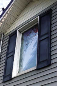
    A broken window of the Cliftons' home was caused during possible tornadic activity early Monday morning.
    As tornadoes touched down around the southern and midwestern portion of the United States over the past couple of days, Northwest Tennessee also saw its share of hazardous weather.
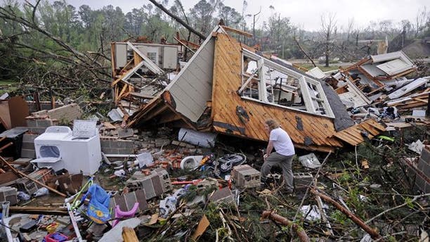
    The Clifton family in the RoEllen community is one Dyer County family that awoke to some intense storm activity on Monday morning.
    According to Deitra Clifton, the family's home and a barn received substantial damage during a potentially dangerous storm on Monday morning. Clifton says at approximately 4:30 a.m., she was awakened by a loud roar and the house shaking. She jumped up and yelled for her daughters to get out of bed and saw her bedroom window was shattered.
    "As I jumped from my bed I heard another noise and looked back to see our bedroom window bursting and breaking," stated Clifton.
    She says the family has a storm shelter on their property and they made a run for it.
    "The girls met me at the bottom of the stairs and we made a run for our storm shelter," stated Clifton. "Each girl had their shoes on, clothed (not pajamas), a flashlight, cell phone, charger, and ID."

    (Photo)
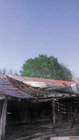
    Monday morning's round of severe weather caused damage to the Clifton family's barns in the RoEllen community in Dyer County.
    Clifton says the property did receive severe damage, but they are thankful and blessed it wasn't any worse and they are still alive. She also notes the importance of each family having a safety plan in the event of severe weather.
    "Having a plan, sticking to it, being prepared, and acting on it is a must in this area," said Clifton.
    Debra Roberson, Northwest Tennessee Chapter of the American Red Cross executive director, added that now is a great time for families to develop and begin practicing a plan of what to do and where to go during a tornado.
    "With our frequency of tornadoes here, it is essential each family has a plan on how to respond during severe weather," said Roberson. "Having a plan saves lives and it doesn't take long to develop one."
    She adds families should also have an emergency survival kit to use in case of an emergency.
    A basic kit should include:
    * Water -- one gallon per person, per day (three-day supply for evacuation, two-week supply for home)
    * Food -- non-perishable, easy-to-prepare items (three-day supply for evacuation, two-week supply for home)

    (Photo)
    * Flashlight
    * Battery-powered or hand-crank radio (NOAA Weather Radio, if possible)
    * Extra batteries
    * First-aid kit --
    Anatomy of a first-aid kit:
    * Medications (seven-day supply) and medical items
    * Multi-purpose tool
    * Sanitation and personal hygiene items
    * Copies of personal documents (medication list and pertinent medical information, proof of address, deed/lease to home, passports, birth certificates, insurance policies)
    * Cell phone with chargers
    * Family and emergency contact information
    * Extra cash
    * Emergency blanket
    * Map(s) of the area
    For more information on dealing with severe weather, visit www.redcross.org