Tuesday, September 29, 2015

Severe Weather in Oklahoma and Texas

Three Killed in Oklahoma, Texas Floods; More Bad Weather on the Way


Weekend flooding that had killed three people through Sunday night left eight other people missing and forced the evacuations of hundreds more across Oklahoma and Texas as emergency crews took stock of the damage caused by the severe weather.
A man was killed in the floods that washed over San Marcos, Texas, according to city officials. A thousand residents in San Marcos' Hays County were displaced by the heavy flooding, which damaged or destroyed at least 400 homes, Hays County emergency management coordinator Kharley Smith told reporters.
Rescue crews were searching for eight people from two families who were missing in the Hays County town of Wimberly, authorities told NBC News. Among them were three children under age 10.
"Now is not the time to try to return to your homes," San Marcos Fire Marshal Ken Bell said Sunday, adding that buildings, power lines and bridges were damaged "throughout the entire region."
The Blanco River in Hays County rose to 40.2 feet — breaking a record crest dating to 1929 by nearly six feet, The Weather Channel reported. The National Weather Service in San Antonio said the river was causing "catastrophic" flooding.
Hays County officials said numerous rescues were under way along the Blanco in the Wimberley area, adding that more officers have been called in to assist. The city of San Marcos announced a 9 p.m. curfew to keep people out of the dangerous weather.
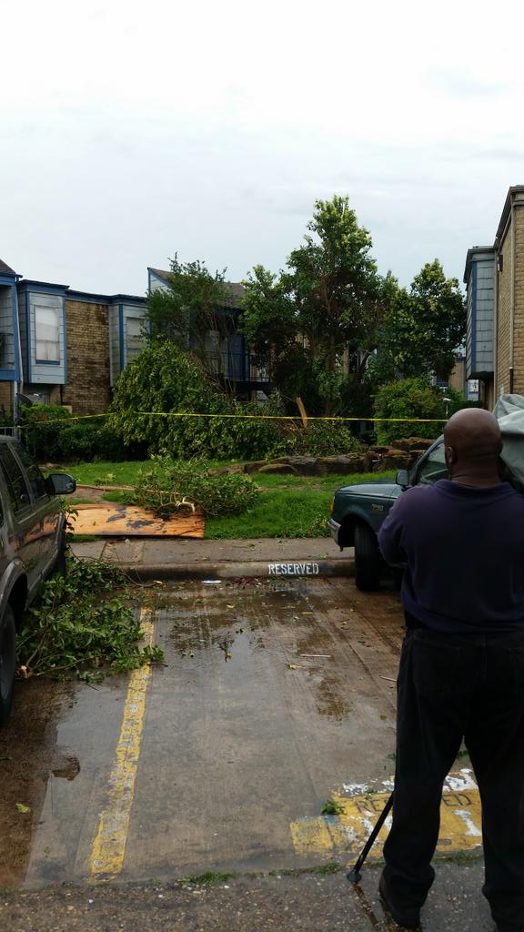
In Houston, heavy rain and winds caused an apartment building to collapse, injuring two people and severely damaging 10 of the 41 units, the Houston Fire Department said.
About 40 miles north of Houston, hundreds of residents were evacuated from their homes Sunday in Montgomery County, where officials feared heavy rainfall might cause the Lewis Creek Dam to break, according to the county's office of emergency management.
A kayaker had to be rescued Sunday morning on the on the San Gabriel River in Georgetown, Texas, after his kayak flipped over, the Georgetown Fire Department said. He was caught in the current for five to seven minutes before a passing family pulled him to safety with a rope.
Fire officials said the looking for excitement in a very unsafe way.
Two people were killed in Oklahoma, one of them a firefighter who drowned after being swept away by flood waters. Claremore Fire Chief Sean Douglas said Capt. Jason Farley was assisting in the rescue of about 10 people who were trapped in duplexes Sunday morning when he was swept into a drainage ditch and drowned. Farley had been a firefighter for 20 years, Douglas said.
The heavy rainfall washed out roads, trapped residents and knocked out power to thousands. A 33-year-old woman died after a car hydroplaned in Tulsa and smashed into the car in which she was a passenger Saturday, the state Department of emergency Management told NBC News on Sunday.
Tornado watches also were in effect for much of eastern Oklahoma and parts of central and south Texas overnight.
A large tornado was confirmed in Oklahoma's Grady County, and several others were reported in the state Saturday evening, The Weather Channel reported.
Six inches of rain triggered flash flooding in Elk City, about 100 miles west of Oklahoma City. Emergency management officials said as many as 30 people were displaced.
The wet and stormy weather was forecast to last into next week for the Plains, Texas and the Mississippi Valley. While there will be a chance of isolated tornadoes, flooding will pose the main threat. One to 3 inches of rain could fall over the next week in Texas, Oklahoma, Kansas and Missouri and parts of Louisiana and Arkansas — and some areas could see 5 inches or more.
Image: George and Susan Kruger make one of three trips with their animals from their flooded house to safety on Sunday, May 24, 2015 in Purcell, Okla.

Severe Weather in the South


Severe Weather Rips Through South, Killing At Least Two


A violent storm system wielding tornadoes, high winds, lightning, hail and rain walloped the South and Midwest on Monday, killing at least two people, according to authorities. The devastation stretched from Texas to Alabama, leaving a path of torched homes, uprooted trees, crumpled cars and downed power lines.
Embedded image permalink
The dead included a 33-year-old former Marine whose Arkansas home was hit by a tornado and a 75-year-old woman in Alabama whose home was crushed by a tree, The Weather Channel reported. Other tornadoes were reported in Missouri, where Game 4 of the American League Championship Series between the Kansas City Royals and Baltimore Orioles was postponed.
The extreme weather was expected to continue roiling the region on Tuesday, affecting an estimated 36 million people, including residents of Memphis, Nashville, Houston, Indianapolis, New Orleans and St. Louis. Flash flooding was expected in many of those places. In Louisiana, Gov. Bobby Jindal declared a state of emergency as thousands of people were without electricity.
Several homes in Little River, Arkansas, about 150 miles southwest of Little Rock, were destroyed. Elsewhere in the state, trees and power lines had toppled, said Rick Fahr, a spokesman for the Arkansas Department of Emergency Management. The storm shut off power to about 7,200 homes and businesses in Arkansas, the Associated Pres reported.
NBC Dallas-Fort Worth reported downed power lines in North Texas following heavy rain and hail Monday morning.
The storms will move southeast on Tuesday. Although the risk of tornadoes is lower in cities from Tallahassee to Cincinnati, rains and winds could still cause heavy damage on Tuesday, according to Weather.com.

Embedded image permalink

Amsterdam Trees Hard-Hit by European Windstorm "Zeljko"; Casualties Reported in Netherlands, Germany, Poland, Slovakia

EDITOR'S NOTE: The text of this article was last updated on Saturday, July 25, 2015.
Residents in at least four European countries will be cleaning up after being blasted by damaging winds from an unseasonably strong low-pressure system and several lines of severe thunderstorms associated with it Friday and Saturday.
At least three people have reportedly been killed and 15 others injured by the stormy weather associated with a strong low-pressure system, which the Free University of Berlin's meteorology department has named Zeljko.

The Netherlands

Enlarge

A woman stands amidst the wrecked branches of a large tree that fell in Amsterdam. The city experienced a long period of high winds due to the low-pressure system named 'Zeljko' on Saturday, July 25, 2015. (Credit: Instagram/Annemarije Heijerman) 
    The Dutch news website Omroep Gelderland said one man was killed in Wolfheze, Gelderland, when a tree fell on himwhile he was standing next to his stopped car outside a hotel. In a separate incident, a passenger was seriously injured and hospitalized after being struck by a falling tree while inside a car in Apeldoorn, according to the same report.
    Another injury was reported in Rotterdam, where wind gusts as high as 52 mph knocked down a market stall. One of the beams of that stall struck and injured a person, according to police officer Sander Boer. In a Tweet, he said: "KNMI [Dutch weather service] code-red warning wasn't for nothing! 1 injured by falling stall beam at #Binnenrotte."
    Trees were felled across much of the country as winds gusted over 50 mph. The wind was particularly tenacious near the coast, where the country's official meteorological agency posted code-red wind warnings. The Hoorn-A oil platform just off the Dutch coast clocked a 78-mph wind gust according to official weather observation data.
    In Amsterdam, sustained winds of 35 mph were reported for four hours straight between 12:55 p.m. and 4:55 p.m. local time, and a peak gust of 63 mph was observed during that period.
    The Dutch weather website Weer.nl says the storm is the Netherlands' strongest July windstorm since modern records began in 1901.

    Germany

    A line of thunderstorms swept northeast through much of the country Friday night, bringing torrential rainfall and numerous lightning strikes, many of them the more powerful but typically rare positvely-charged kind. One of the lightning strikes triggered a fire that destroyed a house in Hamburg; three occupants suffered injuries from smoke inhalation, according to T Online.
    The same high winds that battered the Netherlands also moved into Germany, hitting the northern half of the country especially hard. In Babenhausen, Hesse, a woman was slightly injured when she crashed into a tree that fell right in front of her car as she was driving, according to the Frankfurter Neue Presse.
    RP Online said a man was hurt in Mülheim and der Ruhr when winds knocked a heavy object loose from a crane. It fell onto a wheel loader, pinning the operator inside and seriously injuring him. He was eventually extricated.
    Top wind gusts reported in Germany Saturday included 58 mph in Munster, 53 mph in Paderborn, and 51 mph in Celle and Laage. Winds peaked at 48 mph at Berlin's Tegel Airport as well as in Frankfurt, and 47 mph at the Dusseldorf Airport.
    Enlarge


      Poland

      The European Severe Weather Database says one woman was killed by lightning in a small Polish village near the Czech and Slovak borders as thunderstorms first erupted there Friday afternoon.
      Radar from the Polish government weather agency showed two squall lines of thunderstorms marching east across the country Saturday afternoon and evening. The line in western Poland produced a 59-mph wind gust in Zielona Gora.

      Slovakia

      Lightning struck outside a church during a feast in the village of Kluknava Saturday evening, killing one person and injuring seven others, four of them seriously, according to the website of newspaper Novoveský Korzár.
      A witness quoted in the report said there were about 500 pilgrims attending the event. When the bolt struck, many of the pilgrims were standing outside the church because of its limited capacity, leaving them vulnerable.

      Coastal Trouble

      A stiff easterly fetch off the Atlantic will continue through early Monday morning from the south shore of Long Island, to the Mid-Atlantic coast and southward to the Outer Banks of North Carolina.
      Enlarge

      Beach erosion in Kitty Hawk, North Carolina, along Highway 12 on September 26, 2015.  (OBX Sunrise/Facebook)
        Coastal Flood Advisories and Warnings
        Enlarge
        Coastal Flood Advisories and Warnings
        The latest coastal flood warnings in dark green; coastal flood advisories in light green.
          These persistent onshore will result in additional coastal flooding, particularly during high tide cycles.
          If that isn't enough, astronomical high tides have risen as well this weekend with the full moon (a blood red "supermoon", no less). The risk of moderate coastal flooding is greatest through early Monday morning in the northern Outer Banks, the Virginia Tidewater and Delmarva Peninsula.
          Many of the aforementioned areas have already experienced minor to moderate flooding, with coastal flood advisories in effect.
          However, coastal flooding may also increase farther north to parts of the Jersey shore

          Monday, September 28, 2015

          Confirmed EF2 Tornado Hits Johns Island, South Carolina

          A confirmed tornado hit an area just west of Charleston, South Carolina, overnight, damaging houses and downing trees. No injuries were reported in the twister.
          The National Weather Service confirmed the tornado was of EF2 intensity on the Enhanced Fujita Scale early Friday evening. Two homes were majorly impacted, including one that lost most of its roof and external walls. 
          "One of the low-pressure systems associated with the ongoing coastal event spawned storms that developed a reported tornado," said weather.com meteorologist Ari Sarsalari.
          The hardest hit areas were Johns Island and West Ashley, according to the Associated Press. The tornado damaged homes and downed traffic lights in the area. More than 3,400 homes and businesses were without power early Friday morning, NBC News reported.

          Source: http://www.wunderground.com/news/tornado-south-carolina-east-coast-system-impacts

          Hurricane Marty Brings Flood Threat to Mexico Coast; Hurricane Warning Issued

          • Marty strengthened into a hurricane Monday evening and is located about 140 miles west of Acapulco, Mexico, as of Monday night.
          • Hurricane Marty is expected to slowly move to the east-northeast or north toward the southern coast of Mexico.
          • The center of Marty may stall and then turn west off the Mexico coast midweek while weakening due to increased wind shear.
          • A hurricane warning has been issued for a portion of the Mexico coast from Tecpan de Galeana to Lazaro Cardenas. A tropical storm warning is also in place from Acapulco to east of Tecpan de Galeana and a tropical storm watch is in place from west of Lazaro Cardenas to Punta San Telmo.


          Source: http://www.wunderground.com/news/tropical-depression-seventeen-e-tropical-storm-hurricane-marty-mexico-eastern

          Where There's Fire, There's Smoke


          So far this year, fires have destroyed hundreds of homes and tens of thousands of acres in California. Thanks to the state’s four-years-and-counting drought, those flames are spreading fast and far. But what travels even faster are the billows of smoke from those fires—which means a fire’s impact extends far beyond its perimeter.

          According to the feds, an average human can breathe in about 35 micrograms of 2.5µm particulates over 24 hours before health problems set in. The state’s air quality board monitors those levels statewide, and some of the highest—currently between 10 and 34 micrograms per day—are registering hundreds of miles away from the huge Valley, Butte, and Rough fires.

          Beyond the fire season, California might get some much needed rain from this year’s strong El Niño. Then again, it might not. Either way, Californians probably won’t be breathing easy for a long time.


          Liberal Pope Shakes Up Climate Change Debate


          To Congress, to the U.S. clergy and laity, to the U.N., to 1.2 billion Catholics worldwide, even to non-believers, Pope Francis's message was clear: Climate change is a moral problem and everyone's responsibility. He called on world leaders to set aside partisan and ideological interests in the name of "a higher degree of wisdom."

          "The ecological crisis, and the large-scale destruction of biodiversity, can threaten the very existence of the human species," Francis said. The pope’s visit comes at a delicate time in climate negotiations. UN envoys are in the final steps toward a landmark global agreement, with almost 200 nations, to start reining in fossil fuel emissions. Final talks are set for December in Paris.


          Dry stretch in store as Bay Area waits for El Niño rains

          http://www.sfgate.com/news/article/No-rain-for-at-least-two-weeks-as-Bay-Area-waits-6534770.php

          The chance for an El Niño-triggered early start to the rainy season for the Bay Area was unlikely as more than two weeks of dry days were on the way, forecasters said Monday.
          No rain was expected for the next 16 days around the region and nearly all of California, according to forecast models released by the National Weather Service.
          The dry start to October, though, is not unusual for the region. The Bay Area has a Mediterranean climate, which is defined by hot summers and wet winters.
          October, much like August and September, historically sees little rain. While October marks the month many scientist begin measuring annual rainfall, rainy days usually don’t start until mid-November.
          Wet winters have been elusive as California continues to reel from four years of punishing drought. Much of the state’s landscape had turned into an arid wasteland of dry brush and timber that has fueled catastrophic wildfires.
          This year’s fires have been some of the most destructive ever with thousands of homes burning in massive blazes in Northern California.
          Firefighters on Monday worked to stamp out the remnants of the Valley Fire in Lake County and the Butte Fire in Calaveras and Amador counties, which collectively burned 1,755 homes and hundreds of other structures.
          This year’s El Niño, which is warming ocean surface temperatures in the equatorial Pacific, may bring rain to California in the early winter — but in the meantime, it’s only making things hotter.
          Last month was the hottest August on record and September will likely follow suit. Climate scientists predict that October will have higher-than-average temperatures, compounding the effects of the drought, well before any rain will come.

          When it’s all done, chances are that 2015 will be the hottest year on record.

          No rain was forecast for the next 16 days in nearly all of California, according to the National Weather Service. Photo: NWS

          New York City flood risk rising due to climate change

          http://www.usatoday.com/story/weather/2015/09/28/new-york-city-flooding-floods-flood-hurricane-sandy-climate-change/72987564/
          The risk of major New York City flooding — such as what happened during Superstorm Sandy in 2012 — is likely to occur once every 25 years, rather than every 500 years, as a result of human-caused global warming, says a study released Monday.
          The study, published in the Proceedings of the National Academy of Sciences, found that flood heights have risen about 4 feet since the year 850 to 2005, largely because of sea-level rise.
          "Sea level is rising because of climate change," said Penn State meteorologist Michael Mann, one of the study's scientists. "But climate change also appears to be leading to larger and more intense tropical storms," he said.
          During Sandy, many of New York City's subway and traffic tunnels flooded, and the storm surge breached the sea walls on the southern tip of Manhattan. The high storm surge was the result of a combination of factors, including rising sea level, high tide and the storm's force.
          Monday's study was released a month before the third anniversary of Sandy, which slammed New York and New Jersey coasts on Oct. 30, 2012, killing dozens of people and causing $50 billion in damage.
          "We wanted to look at the impact of climate change on sea level and storm characteristics to see how that has affected the storm surge on the Atlantic coast, specifically in New York City," said Andra Reed, a graduate student in meteorology at Penn State and the study's lead author. "Hurricane Sandy was the motivating factor."
          Adam Sobel, a Columbia University atmospheric scientist who was not part of the study, told the Associated Press that the report, like many others, leaves little doubt that sea-level rise will be more rapid than it had been.
          "This is just one more good study adding certainty to what we know already, which is that coastal cities around the world — including New York, but we're not the only one, nor the worst — are in trouble," Sobel said.
          As for blizzards and nor'easters that aren't hurricanes, "we may see increasing flood heights associated with such storms for the New York City region, at least due to the rising sea levels discussed in our study," the study's Reed said.
          She admits that nor'easters are very different storms than hurricanes, so a definite connection cannot be made.
          Global warming causes sea-level rise in the following manner: As temperatures warm around the world, so do the seas. Heat-trapping greenhouse gases released by the burning of coal, oil and gas cause more ice glaciers and ice sheets to melt and water to expand. Warmer water takes up more space than cooler water. Scientists say global warming will be the primary cause of future sea-level rise.
          AP Superstorm-Task Force


          Five famous cities doomed by climate change

          http://www.theweathernetwork.com/news/articles/five-global-cities-doomed-by-climate-change/57764/

          Sunday, September 27, 2015, 6:57 PM - Whether you believe humans are contributing to it or not, climate change is happening, temperatures are rising and ice caps are melting.
          At this point, even if we limit global temperature rise to 2oC, studies suggest sea levels will still rise by several feet.
          Our civilization is in many ways a coastal one, so when the seas rise, and stay risen, that'll do a real number on world populations and economies.
          Here are five metropolises in climate change's crosshairs.
          Bangkok: Thailand's capital isn't just a popular tourist destination. It's very much a working city, home to 15 per cent of Thailand's 65 million people.
          It's the centre of a major, growing national economy, that nationwide includes a burgeoning manufacturing sector, and an agricultural sector that employs almost half the population around the country.
          And the rising ocean is putting all of it under threat. One expert told AFP in 2011 much of the city, built on swampland, could be underwater in 50 years.
          That's to say nothing of the additional flooding that happens during the monsoon season, or storm surge from the occasional typhoon.
          More powerful storms are likely in the coming century, and the Atlantic reports the monsoon season may be longer and more intense as well.
          Bangkok has already had a taste of what's to come. The city spent a fair bit of coin developing manufacturing on former rice paddies in the Chao Phraya River floodplain, attracting big names like Sony, Honda and Toyota to set up shop. In 2011, massive flooding dealt huge damage to these industries, causing an estimated $45 billion in economic losses.
          It won't get much better as sea levels rise, and just this month 14 Thai provinces were experiencing flooding and landslides as Tropical Storm Vamco passed through the region.
          Venice: This long-lived tourist paradise has had to fight the sea almost from day one from its precarious perch atop the low-lying islands of the Venetian lagoon.
          Once a powerful merchant republic with a wide-reaching Mediterranean trading empire, Venice's star has waned somewhat (The European Centre for Climate Adaptation says the population is down to around 70,000 in the lagoon, mostly due to major decline in industry), but its romance endures.


          Unfortunately, it may finally be on its way to losing its fight to stay afloat, or at least have to pay dearly for it.
          With sea levels continuing to rise, flooding is becoming more common. Tides of 100 cm or more are expected to happen seven times per year, swamping the lowest-lying areas. It'll be harder to attract tourists when they know flooding is more likely, costing the industry up to 42.9 million euros (C$ 64 million) by 2030. That's not even factoring damage to the clam industry and the city's infrastructure.
          But the authorities haven't been sitting there quietly waiting for it to happen. They've poured 5.4 billion euros (C$ 8 billion) into Mose, a series of concrete barriers in the lagoon's inlets that will be raised when the tide is expected to reach above a certain level.
          It could be completed as early as next year, according to the Guardian, but some detractors say it may already be obsolete. In 2009, researchers at Venice's Institute of Marine Sciences said the Mose project was based on sea level rise predictions that may have been underestimated.
          They recommended looking into alternatives, including pumping seawater into a 700 m deep aquifer to raise the city by up to 30 cm, according to the New Scientist.
          Alexandria: This ancient metropolis is situated in the delta of Nile River. It's seen empires rise and fall ever since it was first founded from scratch by Alexander the Great, and has endured for more than two millennia.
          Though nowhere near as populous as the capital, Cairo, its importance to the country is far out of proportion to its size. The port handles four fifths of Egypt's international trade, and is home to 40 per cent of the country's industry, not to mention the tourism potential that comes from its prime Mediterranean location.
          And then there is the delta itself, which is one of the most fertile parts of the country. But, being a delta, its low-lying terrain makes it especially vulnerable to the rising waters.
          Most reports we've seen factor in only a modest sea level rise, but even that could be devastating. A 25 cm increase would put 60 per cent of the city's population underwater (according to the Climate Institute), and a half-metre increase would wipe out 66 per cent of the industry, most of the service sector and about a third of the city's area.
          Beyond the city, the rest of the delta, which accounts for 40 per cent of Egypt's agricultural output, would suffer as well. The Canada-based International Development Research Centre says around 60 per cent of the delta would be affected by increased salinity due to sea level rise.
          It's a potential economic disaster on top of the country's political woes.
          Guangzhou: This Chinese metropolis topped a recent World Bank study as the number one city most at risk of coastal flooding related to climate change.
          That's a huge problem. Guangzhou has already struggled with major flooding due to extreme weather and the occasional typhoon blowing in from the Pacific. In 2010, heavy rainfall killed dozens of people and caused $85 million in damages.
          That last figure pales in comparison to what is to come. By 2070, the city will be home to some $3.4 trillion worth of what the OECD calls "assets at risk." In 2005, more than two million of its denizens were exposed to coastal flooding, but by 2070, that'll be up to 10.3 million.
          Guangzhou is an economic giant among China's economic giants, and both that country and neighbouring India will be hard-hit by sea level rise
          On that World Bank-led study, Mumbai is at number four, with $2 trillion in at-risk assets by 2070, and more than 10 million people exposed to coastal flooding effects.
          Miami: Guangzhou was at the top of the last World Bank-led study, but Miami occasionally makes it into that spot on similar rankings.
          America's beachside Mecca is a haven for sunseekers, but rising sea levels are set to put a serious damper on property values. During spring and autumn tides, the city is already dealing with periodic flooding, and even a 30 cm rise in levels over the next century could prove catastrophic.
          That's just regular ocean activity. It gets worse when you factor in storm surge from major tropical storms.
          2005's Hurricane Wilma brought more than 200 cm of storm surge to the Miami area, a once-in-76-years event. If sea levels rise 60 cm, that kind of storm surge would be likely to happen once every five years.
          The Miami-Dade area of Florida has more people living less than 120 cm above sea level than any other U.S. state except Louisiana, according to the World Resources Institute, accounting for 2.4 million of people whose homes and livelihoods are at risk (according to the Guardian).

          At risk: Around $14.7 billion worth of beachfront property, and $21 billion in tourism revenues. Officials in the state are already planning hundreds of millions of dollars worth of climate change adaptation measures, but it remains to be seen how effective they'll be.

          Local residents use an army boat to cross floodwaters in Kabin Buri, east of Bangkok on October 10, 2013. The Disaster Prevention and Mitigation Department reported that 27 provinces in Thailand are still flooded and 31 people have died due to floods that have drenched swathes of Southeast Asia in recent weeks. AFP PHOTO/ Nicolas ASFOURI

          New research reveals when global warming first appeared

          http://inhabitat.com/?attachment_id=773134

          With the signs of climate change becoming harder and harder to ignore every day, we tend to think of it as a 21st century problem. However, in a new study, a team of researchers has revealed when and where the first real signs of global warming appeared – and it’s a much older problem than we generally think. “Remarkably our research shows that you could already see clear signs of global warming in the tropics by the 1960s but in parts of Australia, South East Asia and Africa it was visible as early as the 1940s,” said Dr Andrew King, lead author of the study.

          By examining the average and extreme temperatures in the temperature record, the researchers were able to pinpoint the first shifts in global temperature. The shifts appeared earliest in the tropics because those areas generally experience a much narrower range of temperature, making any changes easier to detect. In the tropics, the average temperature began to change first, followed later by a shift in temperature extremes.

          Closer to the north and south poles, the temperature began to shift much later, but by the 80s and 90s most regions of the world were showing clear signs of climate change. The one exception is on the east coast and in the central states of the US, which have not yet shown any obvious warming signals.

          The research also gives insights into where the most intense impacts of heavy precipitation caused by climate change are likely to be felt in the future. “We expect the first heavy precipitation events with a clear global warming signal will appear during winters in Russia, Canada and northern Europe over the next 10-30 years,” said co-author Dr Ed Hawkins. “This is likely to bring pronounced precipitation events on top of the already existing trend towards increasingly wet winters in these regions.”

          State of Emergency Declared on Greek Island

          A state of emergency was declared by Greek officials Thursday after torrential rain fell on the island of Skopelos, the filming location of the movie “Mamma Mia!”
          The Valley Morning Star reports the declaration was issued after hours of rain caused power outages, extensive road damage and flooding that swept cars away. 
          "A series of low pressure systems have moved through southern Europe this week, resulting in locally heavy rainfall," said weather.com digital meteorologist Quincy Vagell. "A disturbance in the upper levels of the atmosphere spun over the Greece vicinity for a few days, prolonging a feed of moisture into the area."
          The Greek armed forces have joined efforts to repair the widespread damage, transferring earth moving machines to the island, says Ekathimerini.com. 
          Schools on the island remained closed Friday and dozens of homes suffered flooding damage. Fortunately no serious injuries were reported.

          http://www.wunderground.com/news/greece-skopelos-island-mamma-mia-state-of-emergency-flood

          Full Moon or Sky Full of Clouds?

          Weather conditions will also play a significant role in who is able to catch a glimpse of the historic sight.
          "The current forecasts show that a stubborn low off the East Coast may lead to cloud cover blocking the eclipse from view over the Middle Atlantic region and Southeast," weather.com meteorologist Quincy Vagell said. "A storm system in the north-central states may also bring disrupting clouds from the northern Plains back into the central Rockies. Elsewhere, high pressure is expected to bring good viewing condition to parts of New England, the Midwest, Southwest and the West Coast."
          Most all of North America, South America and Africa will have a chance to see something truly amazing on Sunday when three celestial events – a full moon, a supermoon, and a lunar eclipse – will coincide for a few hours.
          The majority of the viewing area will see the full eclipse for about an hour, but where you are in the world will determine just how late you need stay awake (or how early you need to get up) to take it all in.
          According to USA Today, the West Coast of the United States and Canada have the best timeframe. Folks in Vancouver and Los Angeles can enjoy the sight over dinner with the full eclipse happening around 7:11 p.m. It will last one hour and 12 minutes.
          Eastern U.S. cities, including New York and Atlanta, will have to wait until 10:11 p.m., and South American cities such as Rio will have to wait a further hour.
          Viewers in Europe and Africa will have to get up early on the morning of the 28th, with the full eclipse peaking at around 3:11 a.m. in London and Tangier and about 4:11 a.m. for Madrid and Cape Town.

          http://www.wunderground.com/news/who-has-best-views-of-supermoon-eclipse

          Cold Blob?

          When NOAA released its report on the first seven months of 2015, the map of the globe was almost completely covered in red to signify that most of the planet was experiencing above-average temperatures for the year.
          But there was one big chunk of the North Atlantic Ocean that was a deep, dark blue. Some saw the below-average temperatures of that region as the lone silver lining on the entire map while others questioned why that area was having its coldest year on record.
          As the Washington Post points out, those readings are almost assuredly accurate; NOAA's National Centers for Environmental Information confirmed it. The message that came next from some climate scientists was a quick reminder that this cold "blob" is probably not good news.
          Some experts theorize that the cold water south of Iceland shows the Atlantic Ocean's circulation is slowing, according to a study published in the journal Nature Climate Change. In short, warm and cold water should work together to balance out the temperature of the oceans, Inhabitat said. Cold, salty water should be pushed down below the surface, and warm water should rise up to replace it. Likewise, the warm salt water should move north with the current, and cold water should go south.
          But the massive ice melt occurring in the Arctic has introduced a lot of cold, fresh water into the mix, and it's not behaving the same as cold salt water. It's preventing the sinking that usually happens with cold water, as fresh water is less dense than salt water, and that could be weakening the circulation.


          http://www.wunderground.com/news/north-atlantic-cold-blob

          Typhoon Dujuan

          Just one month after the island nation was battered by the massive Typhoon Soudelor, Taiwan's residents, fearing another disaster, have sheltered from another tropical system bearing down on their country.
          Taiwan's National Fire Agency, part of the Ministry of the Interior, has already reported 50 injuries. There were no deaths and nobody missing at the time of the report.
          So far 7,125 people have been evacuated, more than 2,000 people were spread amongst 72 shelters, and 168,500 households are without running water, the report continued. According to the Taiwan Power Company, 1.8 million households lost power at some point during the storm, with 700,000 people remaining in the dark.
          "To be honest, we all feel very depressed. Any damage may further prolong the time needed for reconstruction," Chou Chih-kang, a Wulai neighborhood chief, told the French Press Agency (AFP).
          Dujuan's approach is just one month after Typhoon Soudelor dumped more than 50 inches of rain in parts of Taiwan. The storm killed at least eight people in Taiwan and 26 in China. At its peak intensity, Soudelor became the strongest storm on the planet in 2015.
          Now, officials are preparing for the possibility of more disaster. At least 24,000 troops have been put on alert to respond to emergencies, and 100 shelters have been prepared in Taiwan, AFP also reported.

          http://www.wunderground.com/news/typhoon-dujuan-impacts