Friday, January 31, 2014

Winter Storm Warning/Rain and High Tides

http://www.google.org/publicalerts/alert?aid=8f330ede9337d7ea&hl=en&gl=US&source=web

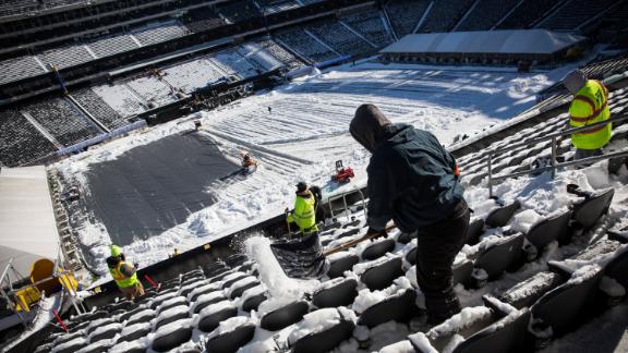
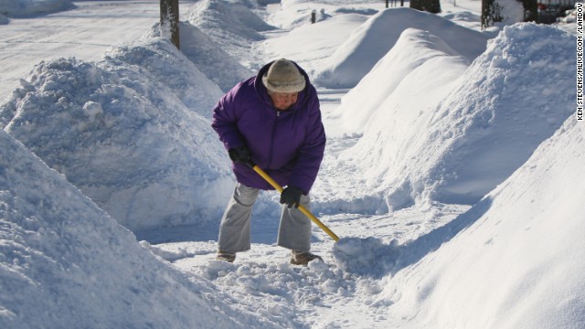
Winter Storm Warning remains in effect from 9 pm this evening to 6 pm CST Saturday.
  • Snow will develop late this evening and increase in intensity after midnight with a period of heavy snow possible during the mid to late morning hours of Saturday. The snow will end by early Saturday evening. Some sleet and freezing rain may mix with the snow south of a line from Ottawa to Joliet to Midway Airport.
  • Storm total snow accumulation 6 to 10 inches. Storm total ice accumulation up to one tenth of an inch, south of a line from Ottawa to Joliet to Midway Airport.
  • Snowfall rates of one to two inches per hour are possible mid morning Saturday.
  • Snow covered roads and low visibilities will make travel hazardous from late this evening through early Saturday evening.
  • Travel through Chicago O`hare and Midway Airports could also be significantly impacted.


River Severn flooding


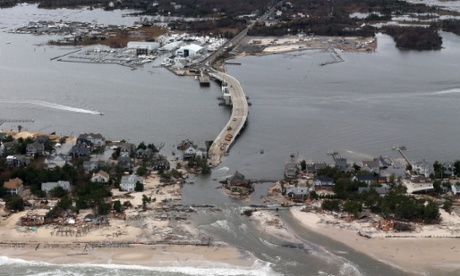
Further warnings are in place along the length of the River Severn amid fears it could burst its banks.
Flood barriers have already been installed in Shrewsbury, Shropshire, and Bewdley, Worcestershire, as the water level rises.

The Environment Agency warned against all non-essential travel amid fears drivers could become stranded, while Gloucestershire Police urged people to stay away from river banks.

Thursday, January 30, 2014

Winter Storm Threat Evolves as Extreme Cold Eases in South, East


The series of storms is forecast to begin this weekend. These will pose forecast challenges related to timing and position of the areas of snow versus wintry mix versus rain. Along the northern and western fringes of these storms will be issues with slippery travel and travel delays.
The first two systems appear to be rather weak, but they can spread a swath of precipitation from the lower Mississippi Valley and the southern Plains to the Northeast Friday into Monday. 
A swath of moderate to heavy snow is forecast during the first storm Friday and Saturday reaching from northern Missouri and southeastern Iowa through Chicago and Detroit and then on to Toronto and Ottawa, Ontario, and Montreal and Quebec City, Quebec. Light snow and a wintry mix will affect northern upstate New York and northern New England. Expect significant travel delays from this storm in the Midwest and in part of southern Canada.


http://www.accuweather.com/en/weather-news/winter-storms-evolve-as-cold-eases-up/22681233

WINTER STORM MAXIMUS


Fridays forecast                                                                   Saturday forecast

Winter Storm Maximus, the 13th named storm of the winter season in the U.S., will help to build snowpack in many drought-suffering locations of the West, and delight skiers and snowboarders in the Rockies.

If that's not enough, Winter Storm Maximus will also produce a messy swath of snow, sleet and freezing through the Plains, Great Lakes, Ohio Valley and interior Northeast.


http://www.weather.com/news/weather-winter/winter-storm-maximus-forecast-california-rockies-midwest-northeast-snow-ice-20140129

Super Bowl 2014 Weather Forecast: Will Cold, Snow, Wind Mess With the Big Game?

Chill Easing 

If you're arriving in the next day or so to attend the festivities, dress in layers.
An Arctic cold front earlier this week sent temperatures on a nosedive. Fortunately, this stubborn cold is on its way out.
Daytime highs Thursday may warm to near the freezing mark. By Friday, continued west-southwest winds should send daytime highs toward the 40-degree mark on the afternoon.
Sounds uneventful, right? But will a lurking winter storm affect the Garden State on Super Bowl Sunday.


Spring Outlook: Six More Weeks of Winter to Grip Half of US


Wintry weather is forecast to hold longest across the the Great Lakes, Northeast and mid-Atlantic.
Cold air masses and a few snowstorms will continue to impact the regions as late as March before the winter season comes to an end.
A steady stream of warmth may not arrive for cities from Detroit to Boston and New York City until mid- to late spring.

The best chances for an early spring will be found in the Southwest. Below-normal snowpack and dry conditions will contribute to a mild end of winter.

"Last year's severe weather season was a quiet season," Pastelok said. "A lot of it had to do with a lot of cold, stable air in place and I see that same situation setting up for this year."
While the season is anticipated to be below normal, it will be more eventful than 2013.
A few episodes of severe weather are possible in the Gulf Coast, where some severe tornado outbreaks occurred in 2013, Pastelok warns.
"I think you have to be concerned there again this year," he said.

Severe weather headed towards South Georgia


ALBANY, GA --
The National Weather Service has issued a Winter Storm Warning from Tuesday afternoon through Wednesday afternoon.

We can expect ice accumulations from a tenth to a quarter of an inch, with locally higher amounts possible. 1 to 2 inches ofsleet or snow is possible along and north of a line from Geneva to Tifton. Elsewhere snow amounts will range from a trace to a quarter of an inch.

The main impact will be icy roads and bridges making driving hazardous. Even small amounts of icing can have significant impacts to travel in the deep south.

If there is more freezing rain than currently expected, power outages could become a concern. Temperatures will be near or below freezing Tuesday night and Wednesday, with wind chills in the teens and 20s.

A Winter Storm Warning means significant amounts of ice, sleet, or snow are expected or occurring. This will make travel very hazardous or impossible.
 

http://www.mysouthwestga.com/news/photos.aspx?id=999675#.Uup7UXkij1o

Wednesday, January 29, 2014

Astronomers Map the Weather on Distant Brown Dwarf

Astronomers studying the weather on distant worlds have made the first global weather map of any object outside the solar system, mapping the movement of clouds on a cosmic body known as a brown dwarf, 6.5 light-years away. Brown dwarfs are cosmological oddities. Too big to be a planet, but too small to be a star, the gaseous bodies reach temperatures around 3,000 degrees Fahrenheit and have clouds made of minerals, rock and droplets of molten iron. Astronomers from Germany’s Max Planck Institute for Astronomy studying two brown dwarfs named Luhman 16A and 16B found complicated weather patterns on the dwarfs and made a complete map of what the weather on Luhman 16B looked like one day last May.


http://www.weather.com/news/science/astronomers-map-weather-distant-brown-dwarf-20140129

Winter Storm Maximus to Bring Snow, Ice to Over a Dozen States, Including Drought-Plagued California

      Winter Storm Maximus, the 13th named storm of the winter season in the U.S, will help to build snowpack in many drought-suffering locations of the West, and delight skiers and snowboarders in the Rockies. If that's not enough, Winter Storm Maximus will also produce a swath of snow through the Plains, Great Lakes, Ohio Valley and interior Northeast. Winter Storm Maximus will produce the lion's share of its snow in the Rockies through Thursday. Amounts over one foot are likely in the Bitterroots, Wasatch, and Colorado High Country. Snowfall in excess of one foot total is also expected in the snow-thirsty Sierra of California, which is welcomed news for concerns about California reservoir levels heavily dependent on spring snowmelt from the Sierra and other nearby ranges. Lighter additional snowfall totals are expected in the Cascades and Siskiyous.

Winter Alerts


http://www.weather.com/news/weather-winter/winter-storm-maximus-forecast-california-rockies-midwest-northeast-snow-ice-20140129

Tuesday, January 28, 2014

The Year in Weather Like You've Never Seen Before

Satellite images often provide crucial information when major storms such as Super Typhoon Haiyan form. But both extreme events and our day-to-day weather are part of a much larger climate system. Now EUMETSAT, the European Union’s satellite agency, has taken that long view and used satellite images to construct an entire year in weather on our planet in high definition.
The new visualization uses data gathered in 2013 from European, Japanese, and American satellites and overlays it on NASA’s Blue Marble images. This is the first time EUMETSAT has put together this type of visualization.
Watching it, it’s easy to see why Super Typhoon Haiyan was one of the biggest weather catastrophes of the year. The storm’s rapid expansion and beeline for the Philippines in November are clearly visible from a bird’s eye view. October’s freak blizzard in the Midwest,powerful windstorms in Europe in November and December, and tropical storms throughout the year are all on display.
However, watching the video also makes it clear that extreme events are only a portion of what makes up our planet’s climate system. Instead, it’s a dynamic system constantly in flux with many features we often take for granted.
Unimpeded by land, storm systems rumble across the Southern Ocean throughout the year. Clouds rarely pass over the dry expanse of the Sahara while in the Tropics, bands of rain shift north or south of the equator depending on the season. The remnants of cyclones are pulled up and away into the jet stream and recycled through planet’s climate system.

Worst of Latest Arctic Blast Hits Midwest; Schools Canceled Again For Dangerous Wind Chills

Winter Weather Ohio

The worst of the latest blast of bitterly cold air was at its strongest Monday night into Tuesday morning, and residents are begging for spring. And thanks to widespread school cancelations, parents were forced to bring their kids to work or leave them at home alone.
"Dangerously cold temperatures will continue in the Midwest for the start of the work week with wind chills in the -20s, -30s and -40s," said weather.com meteorologist Chris Dolce. "In Chicago, the low temperature Tuesday morning will rival the coldest reading we saw in early January. Some cities will threaten daily record lows on Tuesday morning."
In Chicago, temperatures had fallen below zero by Monday afternoon with wind chills in the negative double-digits.
Residents of Minnesota and Wisconsin faced similar if even somewhat more severe weather.
Wind chills in the minus 40s were expected in Minneapolis, while in Milwaukee the chill hit minus 23 by mid-afternoon. Elsewhere, wind chills of minus 18 were expected in Dayton, Ohio, minus 14 in Kansas City, Mo., and minus 3 in Louisville, Ky.
see more at: http://www.weather.com/news/weather-winter/midwest-another-arctic-chill-20140127

Floods hit Italian and French Rivieras

Mediterranean regions of both countries have been badly affected by days of torrential rain.

Submerged

Submerged
The evacuation of people trapped by rising floodwaters in northern Italy continued on Monday.

Island dwelling
The regions around Bologna, Genoa and Florence have experienced widespread flooding which has resulted in the deaths of two people.

Landslide
Although the heaviest of the rain has now cleared, river levels continue to rise.

 Cut off
Hundreds of homes have been evacuated in Bomporto, near Modena after the River Secchia overflowed its banks.
 Fishing for cars
The French Riviera was hit by the same system which caused widespread flooding across northern Italy.

Boats marooned
Le Luc in Provence recorded 144mm in just three days and 51mm fell in Nice on the 17th. Monthly average rainfall across the region is between 40 and 50mm.

 Under water
4,000 homes in the department of Var were left without power and some residents had to be airlifted to safety.
 
 http://www.aljazeera.com/weather/2014/01/floods-hit-italian-french-rivieras-20141219040927840.html


Monday, January 27, 2014

Air pollution from Asia affecting world's weather

      Extreme air pollution in Asia is affecting the world’s weather and climate patterns, according to a new study. Using climate models and data collected about aerosols and meteorology over the past 30 years, researchers found that air pollution over Asia,much of it coming from China, is impacting global air circulations. 
       This is all according to a study by Texas A&M University and NASA's Jet Prpulsion Labroatory researchers. The models clearly show that pollution originating from Asia has an impact on the upper atmosphere and it appears to make such storms or cyclones even stronger. The whole study was funded by grants from NASA, Texas A&M's Supercomputing facilities and the Ministry of Science and Technology of China.


For the full article:

http://www.sciencedaily.com/releases/2014/01/140121130034.htm

Al Gore: 'extreme weather has made people wake up to climate change'

       Last Friday, The former US vice-president Al Gore discussed how recent years extreme weather events such as typhoon Haiyan and Superstorm Sandy  are proving a "gamechanger" for public awareness on the threat posed by climate change. Al Gore explained, "it comes about, of course, because we continue to put 90 million tones of global warming pollution into the atmosphere every day, as if it's an open sewer."
       Also, This fall for the first time in several years, leaders from across the world will discuss efforts to tackle climate change at a meeting convened by Ki-Moon in New York . It comes ahead of a key UN summit in Paris in 2015 to agree on international deal on cutting carbon emissions.


For the full article:

http://www.theguardian.com/environment/2014/jan/24/climate-change-al-gore-davos-haiyan-sandy

Winter Storm Leon Forecast, Vehicles crash in blinding snow squall

http://www.weather.com/news/weather-forecast/winter-storm-leon-snow-ice-gulf-coast-carolinas-20140127


Winter Storm Alerts


Winter Storm Leon will affect a long swath of the Deep South over the next couple of days – including places better known for their beaches, balmy breezes and hurricanes. This will include some of the areas affected by Winter Storm Kronos just last week – but it includes millions of people farther east as well.

The National Weather Service has issued winter storm watches, warnings and advisories from central and southeast Texas eastward along the Gulf Coast and into Georgia, most of South Carolina, central and eastern North Carolina and far southeast Virginia. For Houston, it's the second time with a winter storm warning in just five days.
For Charleston, S.C. and Savannah, Ga., an ice storm warning is in effect, starting Tuesday afternoon in Charleston and Tuesday night in Savannah.


http://www.syracuse.com/news/index.ssf/2014/01/i-81_closed_in_oswego_county_as_vehicles_crash_in_whiteout_snow_squall.html

i 81 ice jam adams 1 10 14.JPG


This is the third time this month I-81 has been closed because of bad weather
The state Department of Transportation shut down the highway at about 10 a.m. today between Exit 37, Sandy Creek, and Exit 36, Pulaski. An alert from the DoT said the closure could last four hours.
The southbound lanes of I-81 were closed Jan. 10 because an ice jam threatened the bridge over Sandy Creek. Both directions had been shut down Jan. 6 because of heavy lake effect snow and high winds.

A fast-moving snow squall was predicted to drop 2 to 4 inches of snow in some areas of Oswego, Jefferson and Lewis counties.

Arctic Blast Drops Temperatures Across the North and Northeast; Will Bring Winter Storm to the Deep South Tuesday and Wednesday

http://www.wpc.ncep.noaa.gov/discussions/hpcdiscussions.php?disc=pmdspd


Temperatures will continue to plunge behind the Arctic boundary that swept through the eastern third of the Nation on Monday. The combination of falling temperatures and gusty winds will make for bitter conditions...and the strong winds blowing over relatively warmer lake waters should allow bands of snow showers to continue to set up downwind of the Great Lakes the next few days. The big story...however...will be farther south as the Arctic front slows down while pushing off the Gulf and Southeast coasts. Moisture working its way north of the boundary should help fuel an expanding area of precipitation across the Deep South and Southeast on Tuesday. Given the fresh supply of Arctic air invading the region...a mix of snow...sleet...and freezing rain is expected within the northern fringe of the precipitation shield...and even portions of the Gulf Coast should see a winter mix by Tuesday evening.

Western U.S. Drought Prompts Disaster Declarations In 11 States

http://www.huffingtonpost.com/2014/01/17/western-us-drought-disaster_n_4616929.html?utm_hp_ref=extreme-weather


Federal officials have designated portions of 11 drought-ridden western and central states as primary natural disaster areas, highlighting the financial strain the lack of rain is likely to bring to farmers in those regions. The announcement by the U.S. Department of Agriculture on Wednesday included counties in Colorado, New Mexico, Nevada, Kansas, Texas, Utah, Arkansas, Hawaii, Idaho, Oklahoma and California. The designation means eligible farmers can qualify for low-interest emergency loans from the department. Agriculture Secretary Tom Vilsack said he and President Obama want to ensure that agriculture remains a bright spot in the nation's economy. "USDA stands with you and your communities when severe weather and natural disasters threaten to disrupt your livelihood." he said in statement.

Alaska Winter Weather Trends Change for the Warmer

While lower North America deals with below freezing temperatures, freak snow storms, and harsh winds, Alaska is experiencing a winter they are not used to. Alaska has started off the new year with temperatures reported in the upper-50s. A record high of 62 degrees was predicted to happen for Alaska in January 2014. Northern Alaska is said to be reaching the 20s when they normally experience negative temperatures constantly during this time. 2013 was Alaska's 10th warmest year in their 95th year of recording. The warming of Alaska is actually more unusual than it being warmer than the lower 48 states during this time of the year. Alaska is normally enjoying comfortable weather while the other Northern U.S. states are chilly at this time. However, Alaska's weather has been a tad too comfortable so far this winter season.

http://www.weather.com/news/alaska-warm-weather-20140123

Unusual Spread of Wildfires in Oregon

This past week at least three wildfires were spreading at the same time in Oregon. Three engines and three crews were needed to put out the fires, adding up to about 120 people. It was expected for some of the fires to last more than a few days, but surprising how much they spread. One fire grew to 273 acres! Very dry winter weather and harsh winter winds lead to these extreme wildfires. The West Coast is getting severe wind that is more similar to Eastern winds for this time of the year. The Santa Anas winds are changing their ways.

http://www.kgw.com/news/Rare-winter-wildfires-erupt-in-northern-Coast-Range-241807301.html

Another Deep Freeze Is On The Way


Northwest Indiana settled into a deep freeze late Sunday that is expected to produce icy roads and dangerously cold temperatures through Wednesday.
Blowing snow and a forecast high temperature of -3 degrees F on Monday will make travel and being outside treacherous, and wind chills could reach -35 to -40. Tuesday’s high is predicted to be zero, with temperatures expected to rise only into the teens by Wednesday, according to the National Weather Service.

Philippines Flooding

Philippines flooding: Residents ride a wooden boat as they paddle past submerged houses due to flooding brought about by heavy rains in the outskirts of Butuan City, Agusan del sur province, in southern island of Mindanao on January 13, 2014. Twenty-two people have been killed and nearly 200,000 others evacuated from floods and landslides that hit a southern Philippine region still recovering from a deadly 2012 typhoon, the government said January 14.


http://globalnews.ca/news/1081133/gallery-extreme-heat-flooding-and-unusually-cold-temperatures-around-the-world/

Unusual Winter Wildfires in Northwest Oregon

In mid-January, a campfire above Glendora, Calif. quickly roared out of control, fanned by Santa Ana winds and ongoing drought conditions, charring almost 2,000 acres and burning 15 structures. 
Wildfires also burned in a few spots in northern California earlier this month, including one prompting the evacuation of Kimball Island in Solano County, and others in Marin and Humboldt Counties.
However, a pair of fires this past week shocked us above and beyond those California events.
A pair of fires flared up along in the Oregon coastal range east of the town of Arch Cape, about 70 miles west-northwest of Portland on January 23. Fanned by winds estimated at 70 mph, the flames had burned around 120 acres as of January 24, according to a story by KGW News Channel 8 in Portland

Sunday, January 26, 2014

Super Bowl Snowstorm Scare

The NFL has been watching the weather radar like hawks in case another bad snowstorm hits New Jersey on Sunday, February 2nd. A lot of football fans are shaking their heads at the thought having the super bowl on a different day rather than the traditional Sunday game day. The more concern is of fan's safety. Last Tuesday, New Jersey's Metlife stadium accumulated 13 inches of snow. Fingers are crossed that nothing extreme will occur on the 2nd. The forecast cannot be determined any earlier than seven days in advance. With the uncertainty of the weather, the Super Bowl could be changed to Friday, Saturday or even Monday. Regardless of what will happen, the NFL is already ahead of the game to prepare fans for the cold weather they will be facing on the day of the Super Bowl. They will provide each fan (about 80,000) with a warm-weather kit in case anyone comes unprepared for the weather to be faced that day.

http://blogs.denverpost.com/broncos/2014/01/23/weather-threatens-super-bowl-sunday/25625/
Super Bowl warm kit

Chicago Schools Closing Down for Second Artic Blast


At the beginning of this month, Chicago experienced weather like no other. Wind gusts reached the shores of Lake Michigan creating an unbearable -42 degrees for January 6, 2014. Yet again, Chicago is getting a cold awakening on January 27, 2014. The Monday blues are getting even harder to deal with this winter.
According to the Chicago Tribune, the negative degree weather for tomorrow will be faced with winds traveling up to 30 miles per hour. After looking at WGN's Emergency Closings list, it is shown that almost all Chicago schools have chosen to close down their facilities due to the harsh weather conditions being predicted. However, other schools have decided to wait to see the true outlook tomorrow morning. The main concern is of younger school children walking to school and waiting outside their bus stops. They may not know how to handle such conditions. Many museums are scheduled to be closed as well, such as the Adler Planetarium and the Shedd Aquarium. Also, Lincoln Park Zoo is planning to remain open by keeping the animals in heated barns. Chicago is not a town prepared for these types of extreme temperatures and it would be best to close down facilities like these for the day rather than to create more risks of safety.


http://www.chicagotribune.com/news/local/breaking/chi-chicago-public-schools-closing-20140126,0,6598411.story

Extreme Droughts Deplete Califoria Lakes

California's reservoirs are severely depleted due to the ongoing widespread drought conditions in the state. As of Jan. 21, 2014, 67 percent of California was in extreme drought, the second worst category possible on the U.S. Drought Monitor.

According to the California Department of Water Resources, Lake Shasta and Lake Oroville are only 36 percent of capacity. Folsom Lake is just 17 percent capacity.

Click on the link to see pictures of the dramatic differences of these lakes before and after the drought. 
http://www.weather.com/news/stunning-photos-californias-lakes-depleted-extreme-drought-20140123?pageno=3

 Home Page

Potential for Severe Weather in the South

There is a chance this week for a potentially major winter storm to affect a long range of the Deep South this week – including places better known for their beaches, balmy breezes and hurricanes. This will include some of the areas affected by Winter Storm Kronos just last week – but it includes millions of people farther east as well.

This storm has the potential to disrupt travel and power. There is uncertainty on the amount of wintry precipitation that will fall. However, if ice accumulations reach the higher end of the range of possibilities, there could be widespread power outages and road blockages due to falling trees and tree limbs, not to mention the weight of ice on power lines themselves.

Travel could become dangerous or even impossible in some areas due to heavy buildup of ice and/or snow. The storm can produce dangerous driving conditions and extended power outages.
http://www.weather.com/news/weather-forecast/winter-storm-gulf-coast-carolinas-florida-snow-ice-20140126

Hartselle, Alabama

Hartselle, Alabama

Relentless Surges of Arctic Air Continue

The blasts of Arctic air have been relentless so far this January for many cities east of the Rockies. A new surge of frigid air will pour southward from Canada behind an Alberta Clipper that will bring snow to the Midwest and Northeast Sunday into Monday. By Monday and Tuesday, temperatures in some cities may rival what we saw in early January.

There's been some more chatter about the "polar vortex", which became a popular catchphrase to describe the blast of bitter cold air at the start of the month. However, just like in early January, this term is being used misleadingly from a meteorological perspective since the actual center of the Northern Hemisphere polar vortex never really moves through the atmosphere above the United States - rather, it remains anchored farther to the north.

There is nothing extremely unusual about this weather since the polar vortex is always present in the winter and there are always spokes and always surges of cold air during the winter in our hemisphere. In any given place or time, the surge of cold air can be more or less intense and travel a longer or shorter distance from the pole.

http://www.weather.com/news/weather-forecast/arctic-cold-finish-january-20140117

Saturday, January 25, 2014

2013 Tied For Fourth Warmest Year On Record, Says NOAA

Last year was tied for the fourth-warmest year on record around the world.
The National Oceanic and Atmospheric Administration on Tuesday released its global temperature figures for 2013. The average world temperature was 58.12F (14.52C) tying with 2003 for the fourth-warmest since 1880.
Nasa, which calculates records in a different manner, said Tuesday that 2013 was the seventh-warmest on record, with an average temperature of 58.3F (14.6C).
Hurricane Sandy damage
Both agencies said nine of the 10th warmest years on record have happened in the 21st century. The hottest year was 2010.
A global insurance firm says there were 41 billion-dollar weather disasters last year. Unlike 2012, most of the heat and disasters were outside the United States.

Philippines Attempting Recovery After Typhoon Haiyan

Emergency workers have evacuated thousands of people across the southern Philippines, including many already made homeless by a typhoon in November, after three days of rain flooded towns and farmland.
Hundreds of survivors of Typhoon Haiyan – one of the strongest storms ever to make landfall – were forced to flee by tropical depression Agaton after emergency shelters were damaged or destroyed on the eastern central island of Samar.
Tents collapsed under the weight of the rain and emergency plastic sheets have been torn away, Oxfam said.
An average of 20 typhoons hit the Philippines every year with Haiyanslamming into central islands on 8 November, killing more than 6,100 and wiping out entire coastal communities in Leyte and Samar.
More than 200,000 people have been taken to shelters over the past three days as flood waters rose, but hundreds were still marooned on the roofs of their houses on Tuesday, said Eduardo del Rosario, executive director of the National Disaster Risk Reduction and Management Council.
Del Rosario said 42 people had been killed, 65 had been injured and damage to property and farms had reached 367m pesos (£5m).
"Our troops are trying to reach them and bring them to safer ground," Del Rosario said.
Nenita Matuda, 45, and her children perched on their neighbours' roof as she watched the rampaging waters outside Butuan City in the north of Mindanao island.
"Thank God we are safe but we just lost our house," she said.
A state of calamity has been declared in Agusan del Norte and 15 other towns in the Davao del Norte, Surigao del Sur and Agusan del Sur areas of Mindanao even as the weather bureau lifted alert levels as the storm weakened.

Philippines storm Agaton in Butuan city

Super Bowl Looking Cold But Clear

It appears the Denver Broncos and Seattle Seahawks will have manageable weather conditions for Super Bowl XLVIII.
According to weather.com, the Feb. 2 forecast for East Rutherford, N.J., calls for a high temperature of 35 degrees, a low of 25, and just a 30 percent chance of snow. Winds are expected to be at eight miles per hour. Accuweather.com calls for a high temperature of 36 and a low of 26 with the possibility of snow showers.
The league and workers at MetLife Stadium used this week's snowstorm that dumped over a foot of snow in the New York metropolitan area as a dress rehearsal for if another storm hit during Super Bowl week. Eric Grubman, a league vice president, said at a news conference earlier in the week he was confident the game would be played if there were a severe snowstorm the day before, but offered no details of what would happen if heavy snow hit on Super Bowl Sunday.Weather has been a major topic of discussion in leading up to the first cold-weather Super Bowl. NFL officials have said they could change the time or day of the game in the case of a severe snowstorm but remain committed to the current kickoff time of 6:25 p.m. ET.
Grubman said the league would require 24 hours to move the game time and 36 hours to switch days.
The coldest temperature for a Super Bowl was 39 degrees at Tulane Stadium in New Orleans on Jan. 16, 1972.
ESPNAPI_IMG_NO_ALTEXT_Value

Thursday, January 23, 2014

Chicago Weather: City, suburbs to face arctic blast once again

A days-long stretch of frigid, subzero wind chills is just beginning in the Chicago area.

The wind chill in Chicago was minus 8 degrees at 4 a.m. Wednesday, while the actual temperature stayed steady around 2 degrees, according to the National Weather Service.

To prepare for the extreme cold, the Illinois Tollway activated 11 Zero Weather Road Patrols Tuesday to help customers stranded in their cars. Seven Illinois Tollway oases also serve as warming centers.
This particular blast of cold air is not the polar vortex itself, but rather a byproduct of the system that regularly moves through Canada and into the United States, meteorologists said.
By Friday, highs in the area are expected to climb to 24 degrees, falling to 15 at night, forecasts show.


What's with this wacky weather? Hot is cold and cold is hot


(CNN) -- What's with this wacky weather?

It's so cold in Florida that farmers joke the oranges are squeezing themselves to stay warm.
But Alaska is so warm that a ski resort's been forced to close.
Add to this curious mix, giant waves in Hawaii, a historic drought in California, and bears coming out of hibernation in Nevada, and you can't help but wonder: What is going on with the weather?

"It's not actually that unusual," says Roger Edwards, a meteorologist with the Storm Prediction Center at the National Weather Service.
Usually a few times each winter, the temperatures flip-flop where Tallahassee is colder than Anchorage.
"But," he says, "this one is more persistent than we normally see."

On Tuesday, 10 inches of snow fell on MetLife Stadium, which hosts the Super Bowl in 10 days.

Contrast that with Anchorage, Alaska, where Thursday's forecast high will be around 45 degrees. A typical high would be in the low 20s.

Waves up to 50 feet high have been pounding the North Shore of Oahu -- the largest Hawaii's seen since 2004.

What's causing it? A large storm with hurricane-force winds that's sending a giant swell toward the island. The surf peaked overnight, the weather service said.

California's facing perhaps its worst drought since record-keeping began a century ago, California Gov. Jerry Brown proclaimed this month.

The National Weather Service's forecast for Incline Village, Nevada, for instance, calls for high temperatures heading to or well past 50 degrees for the next week at least, with nary of snow flurry in sight.