Monday, September 30, 2019

Montana is blanketed in record-breaking snow and it's not even October yet

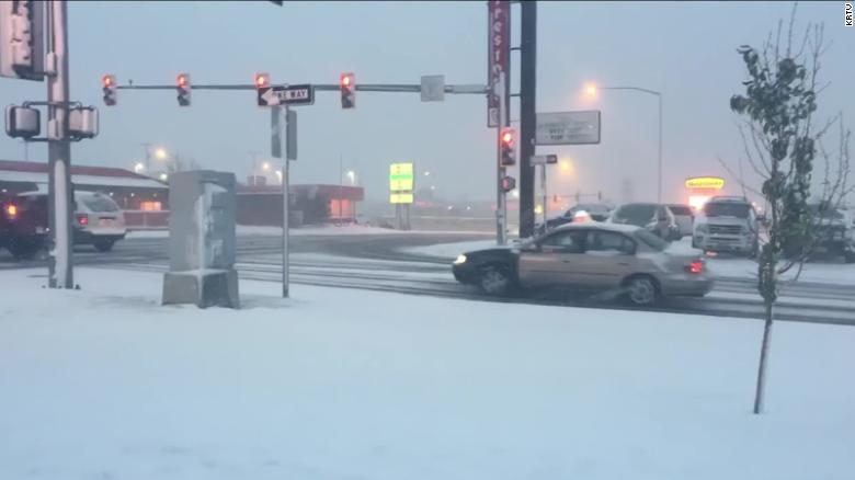
Record amounts of snow have fallen in parts of Montana over the past few days -- and it's only September.
Great Falls, Montana, got 9.7 inches of snow Saturday, the highest one-day September snow amount for that city, followed by 9.6 inches Sunday, the second highest, the National Weather Service said.
But even higher amounts fell in other areas of Montana from Friday into Monday morning. Browning got a whopping 4 feet, according to the weather service. The Dupuyer area got 37 inches, and the Heart Butte area saw 34 inches.
"This has never happened, ever" in September, said Ray Greely with the weather service in Great Falls.
    Great Falls' two-day accumulation of 19.3 inches of snow is the second highest recorded in that city for any time of the year, the weather service said, behind the 24.2 inches from April 27-28, 2009.
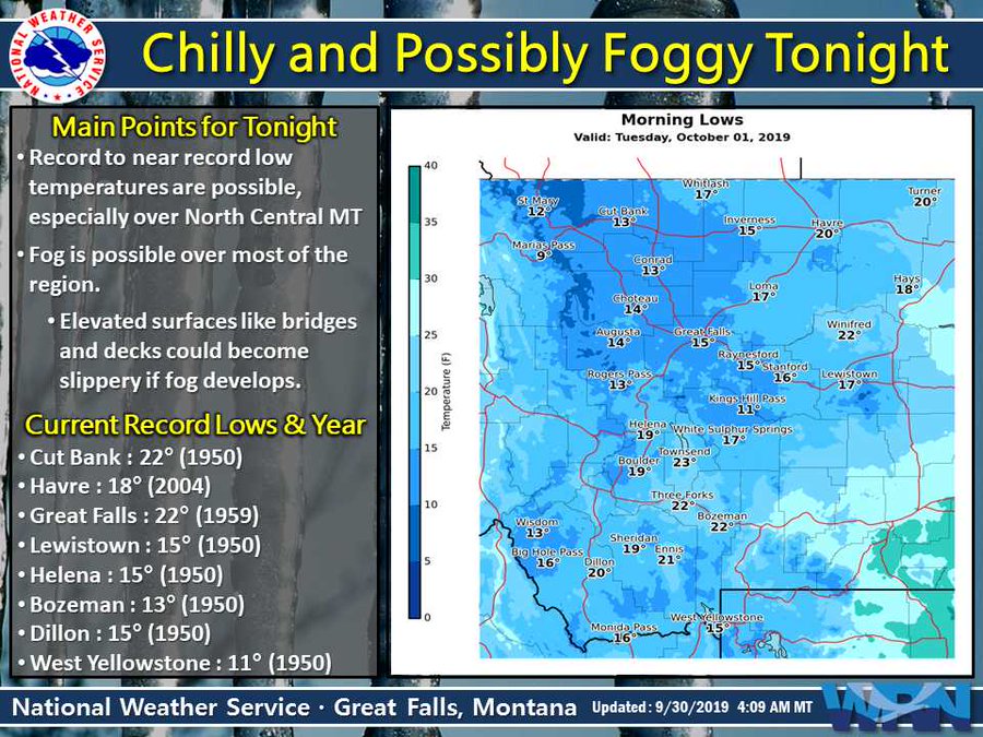
    Temperatures in the Great Falls area are forecast to reach record or near-record lows Monday night, the weather service said.
    "With an unprecedented winter storm throwing our state a surprise in September, state and local governments are working closely together to protect the health and safety of Montanans and our top priority is making sure that happens," Bullock said.

    View image on Twitter

    Snowfall in Choteau, Montana.

    Lorenzo Will Go Around the Azores

    Another  hurricane will approach the region of Portugal. Hurricane Lorenzo will skirt past the Azores later this week as a Category 2 hurricane. Several parts of the islands in the Atlantic were under a hurricane or tropical storm watch as Hurricane Lorenzo inched closer and closer. The Category 2 storm has threatened the Azores for days. Early Monday, it was about 1,160 miles from the islands and packing 110 mph winds. The Azores is a group of paradise-like islands roughly 950 miles west of Lisbon, Portugal. As Lorenzo approaches, it will bring up to 6 inches of rain over most of the western Azores and up to 2 inches over the central Azores. The rainfall could cause life-threatening flooding in the western portion of the Azores. Sao Miguel and Santa Maria are under tropical storm watches as well. Lorenzo's hurricane-force winds currently extend 90 miles outward from the storm's center and its tropical storm-force winds extend 255 miles out. As hurricane Lorenzo moves closer, Portugal’s Azores archipelago is bracing for strong winds, heavy rain and towering waves and the country’s meteorology agency IPMA said there was more than an 80% chance of the storm hitting the mid-Atlantic islands. Western islands of Flores and Corvo are likely to be most affected, as well as the central islands of Sao Jorge, Pico, Graciosa, Faial and Terceira, one of the largest of the archipelago. 


    Link to article:
    https://www.cnn.com/2019/09/30/weather/hurricane-lorenzo-monday-wxc/index.html

      Bihar and Uttar Pradesh: More than 100 dead in fresh India flood chaos

      More than 100 people have died due to flooding caused by heavy rains in the Indian states of Uttar Pradesh and Bihar.
      The city has been deluged with rain since Friday, submerging many residential areas. People are navigating the main roads - which are dotted with abandoned and partially submerged vehicles - by boat.
      The PTI news agency quoted an official as saying that the amount of rain the city received was "completely unexpected". In many parts, the rain water has mixed with overflowing sewage, and the dirty water has entered several homes.
      A digger on a flooded road
      A satellite image of the Ganges river overflowing on 29 September 2019

      Dangerous air quality returns to Bangkok

      Unseasonal, poor air quality has descended on Bangkok and surrounding suburbs threatening people’s health. The problem, which filled the headlines at the end of last year, has returned to parts of the capital over the weekend.
      Readings up to 233 have been recorded this morning, well in excess of the 50 micrograms per cubic metre safety level. That means that the general air quality is now ‘very unhealthy’
      Thick smog covers Samut Prakan and Bangkok on Monday morning. (Photo by Somchai Poomlard)
      Dangerous air quality returns to Bangkok - Readings up to '233' today | News by The Thaiger
      Websites: 

      California city hit by series of weird weather events, including tornado and hail

      Weird weather struck Davis, California, over the weekend. The area experienced a tornado touchdown, pounding hail and record low morning temperatures.The tornado caused a bit of excitement, but apparently no damage.Shasta Fields told CNN that she and her boyfriend, Tom Nolan, came close to the twister. In video posted on Twitter, Nolan, an amateur storm chaser, can be heard yelling, "Look at you, you are beautiful," as the tornado starts to form.The National Weather Service of Sacramento issued a tornado warning at 6:39 p.m. PT on Saturday for a thunderstorm to the north of Davis, and advised people to take shelter. A University of California at Davis atmospheric student reported seeing the tornado touch down at 6:41 p.m. to the east of Highway 101A and Highway 27, the NWS said, adding that no damage was reported.CNN Weather producer Robert Shackelford said the tornado was much weaker than Midwestern tornadoes typically are. "California sees about 10 tornadoes a year, so this is rather rare for the area," he said. "They are more likely to see tornadoes in the winter and spring, but it isn't uncommon to see tornadoes in the fall." A little bit before the tornado, heavy hail fell on the Davis area. Again, no damage was immediately reported.

      Wintry weather knocks out power for 2,000 homes, drops record snow Saturday night

      As much as 3 inches of snow sat on the ground in parts of the Spokane area Sunday morning after wintry weather downed trees and knocked out power for more than 2,000 homes throughout the Inland Northwest.
      The National Weather Service recorded 1.9 inches of snow at the Spokane International Airport on Saturday, setting new daily and monthly records. It was the first measurable September snowfall in Spokane since 1926.
      Another 1.3 inches of snow fell between midnight and 6 a.m. at the airport, setting another daily record, according to the weather service. Overnight temperatures reached a low of 32 degrees, with a wind chill as low as 21 degrees at 1 a.m. when the wind was blowing at about 16 mph.
      The extreme weather left about 730 Avista customers without power as of 4:45 p.m. Sunday after crews restored power to more than 2,000 homes overnight, the utility said on Twitter. About 700 of those homes were in the Colville area, where as much as 16 inches of snow fell overnight.
      Kootenai Electric said close to 100 customers were affected by an outage in North Idaho at 9 a.m., KHQ reported. No outages were reported as of 11 a.m.
      Stevens County dispatchers started receiving reports shortly after 11 a.m. that Verizon voice and data services were down for central and northern areas of the county, said Rick Anderson, the county’s 911 coordinator.
      Anderson said sheriff’s deputies were unable to use their laptops in their patrol vehicles because they use Verizon to connect to the internet.
      It was not clear if the outage was weather-related or when the issue would be resolved, Anderson said late Sunday afternoon.

      Friday, September 27, 2019

      Severe Weather, including Tornadoes and Flooding, Possible For Parts of Plains, Midwest Into the Weekend

      A disturbance is quickly moving across the southern Great Lakes with a round of strong to locally severe thunderstorms. A few of these storms may produce hail up to 1 inch in diameter. Some of these storms are producing also 1-2 inch per hour rainfall rates.
      Several spots have seen more than two inches of rain already today, including Peoria, Illinois, which has already seen 5.25 inches. Flooding has been reported in Peoria since early Friday afternoon.
      This rainfall will set the stage for flooding overnight. Flash flood watches have been issued from eastern Kansas and northern Missouri to northern Illinois and northwestern Indiana, and include the Kansas City and Chicago metro areas.
      This disturbance is expected to move eastward quickly enough for the atmosphere to recover over Iowa, Missouri and Illinois. This recover is expected to allow severe thunderstorms to develop with a new disturbance over the next few hours.


      Chicago Weather Live Radar: Severe storms possible Friday, Tornado Watch for LaSalle, Livingston counties

      The most likely threats are very heavy rain, winds and the possibility of hail. The strongest potential for severe storms is in areas south and west of Chicago, particularly in the far south and southwest suburbs.

      A Flash Flood Warning is in effect in LaSalle and Livingston counties until 7:30 p.m.

      A Flash Flood Watch is in effect for Cook, DeKalb, DuPage, Grundy, Kane, Kankakee, Kendall, LaSalle, Livingstone and Will counties in Illinois and Jasper, Lake, Newton and Porter counties in Indiana until 3 a.m. Saturday.

      The first wave of rain began moving into the area around 10 a.m. Another round of heavy rain is expected later in the afternoon and into the evening which could bring an additional one to three inches of rain to some areas, according to ABC7 Meteorologist Larry Mowry.

      The weather is impacting Chicago's airports. As of 5:30 p.m. O'Hare International Airport reported average delays of 87 minutes and 757 flight cancellations, while Midway International Airport reported delays averaging 16 minutes and 65 flight cancellation

      https://abc7chicago.com/weather/chicago-weather-heavy-rain-potentially-severe-storms-expected-friday/5573088/

      Thursday, September 26, 2019

      Tropical Karen Storm Soaking Puerto Rico + Virgin Islands.

      The Tropical Storm Karen has drenched south-central Puerto Rico, causing a river to wash away a bridge and cutting off at least 15 families. Even as Karen moves away from the US territory, it'll bring heavy rainfall, strong thunderstorms and flooding threats.This could be enough to bring down trees. Strong rip currents will also be a danger for the next few days. On the 25 of September the center of Karen was 330 miles north-northeast of San Juan. The storm weakened and had sustained winds up to 40 mph as it moved north at 14 mph. On the forecast track, the center of Karen will continue to move farther away from Puerto Rico and the Virgin Islands. After leaving Puerto Rico, Karen is forecast to remain a tropical storm in the Atlantic for the next few days. By storm's end, Karen will generally have dropped up to 6 inches of rain in Puerto Rico, with some isolated areas getting up to 8 inches. These rains may cause flash flooding and mudslides, especially in mountainous areas. 
      Link to  article:
      https://www.cnn.com/2019/09/25/weather/tropical-storm-karen-wednesday-wxc/index.html

      1st blizzard of season to wallop northern US with up to 3 feet of snow

      Parts of the Northwest and southern Canada are bracing for a potentially 'historic' snowstorm that will unleash heavy snow, fierce winds and record cold — and meteorologists say the timing of this storm will add to the dangers.
      Hazardous travel conditions and power outages will result as blizzard conditions will unfold in some areas, according to AccuWeather meteorologists.
      On Wednesday, the National Weather Service (NWS) in Missoula, Montana, warned that the storm has the potential to be "historic" due to its occurrence so early in the season. Life-threatening conditions in the backcountry and damaging winds were among the dangers the NWS office highlighted in a tweet.
      AccuWeather spoke with Rebecca Connors, public information officer for the City of Helena Public Works, in anticipation of the early snowstorm.


      "It’s Montana, and this is kind of the characteristic of Montana, freak snowstorms. Our seasons are short except for winter," Connors told AccuWeather.


      Wednesday, September 25, 2019

      Could Karen Take Another Weird Loop Toward the U.S. Like Hurricane Jeanne Did 15 Years Ago?

      Tropical Storm Karen has an uncertain, strange future ahead, and one possibility is a loopy track eerily reminiscent of Hurricane Jeanne, one of the big hurricanes of 2004.
      Karen is currently gliding northward, but its forward speed is expected to come to a halt late this week.This can happen when large-scale features such as the Bermuda-Azores high weaken, leaving the storm without any appreciable steering winds for a period of time.
      Stalled tropical cyclones with weak steering winds are among the most difficult scenarios for computer models to forecast correctly.
      Even with less hostile shearing winds and warm ocean water, Karen could succumb to dry air and fizzle in or near the Bermuda Triangle.
      For now, Karen is expected to begin moving west this weekend as high pressure responsible for a prolonged early-fall heat wave rebuilds over the eastern U.S. and western Atlantic Ocean and becomes the system's steering wheel.
      But that doesn't mean it would be able to make the entire journey west toward the Bahamas or Southeast U.S. without falling apart.
      The bottom line is that it's too soon to determine the path and intensity of Karen.
      In September 2004, Tropical Storm Jeanne moved through the Caribbean. Its slow movement caused catastrophic flooding and landslides in Haiti and killed more than 3,000 people.
      Hobbled by land interaction with Hispañiola, Jeanne temporarily lost its atmospheric steering wheel.
      This was due largely to Hurricane Ivan, which made landfall along the northern Gulf Coast and eroded Jeanne's steering high pressure to its north.

      Severe weather: Strong tornadoes, very large hail possible in southern Minnesota

      UPDATE 8 A.M. 

      This is the latest severe weather risk from the Storm Prediction Center, which is slightly different from the map shown in the original blog posting. The orange area has the highest chance of seeing nasty storms. A late-September severe weather event is appearing more and more likely Tuesday as a strong cold front is forecast to move through Minnesota. 
      "Tornadoes, large hail, and damaging wind are all possible late this afternoon and evening across much of the area," says the National Weather Service in the Twin Cities. "The greatest threat, including for some strong tornadoes, will be from south central and southeast MN into WI. Hail larger than golf balls is also possible."
      Minnesotans will experience cool, dry air in the morning but that will quickly change as moisture surges into the area, with dewpoints rising close to 70 by the afternoon. That will set the stage for explosive storm development during the afternoon and evening hours. 

      Tuesday, September 24, 2019

      CHASING ICE – 2014 EMMY® AWARD WINNERS!

      Chasing Ice is honored to have received the 2014 News and Documentary Emmy® award for Outstanding Nature Programming!! The film made its TV debut on the National Geographic Channel on April 19, 2013. Since that day, Chasing Ice has screened in more than 172 countries and on all 7 continents.

      https://chasingice.com

      James Balog


      For more than 30 years, photographer James Balog (“BAY-log”) has broken new conceptual and artistic ground on one of the most important issues of our era: human modification of our planet’s natural systems. An avid mountaineer with a graduate degree in geography and geomorphology, James is equally at home on a Himalayan peak or a whitewater river, the African savannah or polar icecaps.
      To reveal the impact of climate change, James founded the Extreme Ice Survey (EIS), the most wide-ranging, ground-based, photographic study of glaciers ever conducted.  He and the EIS team are featured in the 2012 internationally acclaimed, Emmy award-winning documentary, and in the 2009 PBS/NOVA special, Extreme Ice.


      https://chasingice.com/team-member/james-balog/


      Museum Science and Industry 


      Strong Earthquake Jolts Pakistan, Kills 22 and Injures 700

      MIRPUR, Pakistan—A powerful 5.8 magnitude earthquake struck northeast Pakistan on Sept. 24, badly damaging scores of homes and shops and killing at least 22 people and injuring over 700, officials said.
      The quake badly damaged a key road leading to the town of Mirpur in the Pakistan-administered part of Kashmir and adjoining villages, where most of the damage was located.
      Mushtaf Minhas, information minister in Pakistan-held Kashmir, said 22 people, including women and children, were killed in the quake, mostly due to collapsing roofs and walls.
      According to Pakistan’s Meteorological Department, the epicenter of the 5.8 magnitude quake was located near the mountainous city of Jehlum in eastern Punjab province. The earthquake shook walls across the country and left people waiting in the streets fearing aftershocks.
      https://news.ntd.com/strong-earthquake-jolts-pakistan-kills-22-and-injures-700_384044.html?fbclid=IwAR0zK1bbc0xWnBNC8B85usafhsie2U4MreOdKoZQWuJ3kuJOW5I9g3azNf8

      Monday, September 23, 2019

      The highest rainfall totals from Tropical Storm Imelda across southeast Texas

      It's been less than a week, and Texans are still reeling from the effects of Tropical Storm Imelda, with many homeowners beginning to asses the damage caused by floodwaters.Imelda dumped more than 40 inches of rain in some parts of the Lone Star State. She has been compared to one of the most devastating natural disasters to wreck the Texas coast - Hurricane Harvey.Before the storm moved across Houston on Wednesday and Thursday, it had already dropped 22 inches of rain in 48 hours in Sargent, Texas. By the time it began drizzling across the Bayou City, many had let their guards down, assuming the worst of the storm had passed.But by Thursday, Imelda began to truly show her wrath, dropping several inches across Houston and the southeast Texas region, leaving many stranded on roadways, inside flooded homes and five unfortunate souls dead. Parts of Interstate 10 were shut down after floodwaters made the roadways impassable, one small town was completely flooded, and first responders worked around the clock overnight to rescue stranded motorists and homeowners.Texans will be picking up the pieces left by this storm, as well as the last, for many years to come.

      Tropical Depression Karen to Impact Puerto Rico and the Virgin Islands Early This Week; Tropical Storm Warnings Issued

      Tropical Depression Karen will bring heavy rain and gusty winds to Puerto Rico and the Virgin Islands early this week, but it's too soon to know if it will eventually affect any other land areas, including the mainland United States.
      Karen is centered more than 100 miles south of San Juan, Puerto Rico, and is moving north-northwestward at 10 to 15 mph.Tropical storm warnings are in effect for Puerto Rico, Vieques, Culebra and the U.S. and British Virgin Islands. Tropical-storm-force winds (39-plus mph), especially in gusts, are expected in these areas by early Tuesday morning. Winds could be stronger on the windward sides of hills and mountains.Karen is forecast to track northward toward Puerto Rico and the Virgin Islands, where heavy rain and tropical-storm-force winds can be expected Tuesday into Wednesday. No significant intensification is expected since Karen is battling wind shear and dry air.
      Rainfall totals of 2 to 4 inches (locally, up to 8 inches) are possible in Puerto Rico and the Virgin Islands through Wednesday.
      The rainfall could trigger flash flooding and mudslides in parts of those islands, particularly in mountainous terrain. A flash flood watch has been issued by the National Weather Service for Puerto Rico and the U.S. Virgin Islands.
      The bottom line is that the forecast for Karen remains highly uncertain beyond late this week. It's too early to know whether Karen could eventually affect the mainland United States or the Bahamas late in the weekend or early next week.

      Indonesia haze causes sky to turn blood red

      Skies over an Indonesian province turned red over the weekend, thanks to the widespread forest fires which have plagued huge parts of the country.
      Every year, fires in Indonesia create a smoky haze that can end up blanketing the entire South East Asian region. Indonesia meteorological agency BMKG said satellite imagery revealed numerous hot spots and "thick smoke distribution" in the area around the Jambi region.
      Professor Koh Tieh Yong, of the Singapore University of Social Sciences, explained that this phenomenon, known as Rayleigh scattering, has to do with certain types of particles that are present during a period of haze.  Prof Koh added that this phenomenon would not "modify the air temperature".
      Village of Mekar Sari in Jambi province
      Village of Mekar Sari in Jambi province

      Hurricane Humberto's Leaves 80% of the Island Without Power

      Hurricane Humberto at Bermuda leaves 80% of the island without power.Hurricane Humberto's core has passed its closest point of approach to Bermuda, but its strong hurricane-force winds will continue whipping the island. It is shown that more close to 28,000 customers which is 80% of the territory was left in the dark. The category 3 storm was packing sustained winds of  120mph. The storm's wind has extended up to 80 miles outward from its center. A buoy measured a wave of more than 30 feet  The southern coastal parts of the island are under flood warning threat. Hurricane Humberto could bring up to 6 inches of rain. Swells will continue to affect the northwestern Bahamas and the southeastern coast of the United States from east-central Florida to North Carolina. Large swells will continue to increase, the swells could cause life-threatening and rip current conditions. Humberto is one of three storms drawing attention in the Atlantic basin. Hurricane Humberto is the  second major Atlantic hurricane. Hurricane often do not approach Bermuda. Only 21 hurricanes have passed within 100 miles of Bermuda over the past century, with Hurricane Gonzalo in 2014 the last to make landfall there.


      Link to article:
      https://www.cnn.com/2019/09/18/weather/hurricane-humberto-bermuda-wednesday/index.html

      Tropical Storm Karen to unleash heavy rain, trigger flood risk from Puerto Rico to U.S. and British Virgin Islands

      Tropical storm warnings were issued for Puerto Rico and the United States and British Virgin Islands Monday as Tropical Storm Karen moved northwest through the Caribbean Sea.
      While Karen is forecast to remain weak through the middle of this week, the tropical storm is likely to cause heavy rain over part of the northern Caribbean islands. AccuWeather meteorologists expect Karen to take a northerly path that will bring the system well northeast of the Turks and Caicos and the Bahamas on Thursday, but not before passing through Puerto Rico and the U.S. and British Virgin Islands on Tuesday. 
      A hurricane hunter aircraft was investigating the storm early Monday, according to the National Hurricane Center. As of 2 p.m. Monday, Karen was located about 210 miles south-southeast of the Puerto Rican capital of San Juan and had maximum sustained winds of 40 mph.


      Saturday, September 21, 2019

      'They're forming like roaches.' The 6 tropical storms whirling at once have tied a record

      Sure, it's the middle of hurricane season. But this is ridiculous.
      The six named storms whirling at once this week in the Atlantic and Pacific hit a record first set in 1992, forecasters reported.
      "While Humberto and Kiko were spinning in the Atlantic and Eastern Pacific, four new tropical cyclones formed Tuesday: Imelda and Jerry in the Atlantic Basin, and Mario and Lorena in the Eastern Pacific Basin," the Weather Channel reported.
      This combined number of active storms in both basins was believed to tie a modern record, set in September 1992, according to National Hurricane Center forecaster Eric Blake.
      He tweeted Tuesday that "they are forming like roaches out there."
      "It's not something that you see all the time, but not unheard of, either," said Weather Channel meteorologist Danielle Banks. 
      According to the National Hurricane Center, there have been as many as five active Atlantic tropical cyclones at once, which occurred Sept. 10-12, 1971. In the eastern Pacific, on Aug. 26, 1974, there were five simultaneous named storms of at least tropical storm strength, Phil Klotzbach, a tropical scientist at Colorado State University, told weather.com.
      September is the peak month for hurricane and tropical storm activity in both the Atlantic and Pacific, NOAA reports. 
      "In September, ocean temperatures are nearly at their yearly peak, and shearing winds that can rip apart tropical storms and hurricanes are typically at their lowest," the Weather Channel reported.
      https://www.usatoday.com/story/news/nation/2019/09/19/hurricanes-tropical-storms-atlantic-pacific-set-record-kiko-humberto-jerry-imelda-mario-lorena/2373241001/

      Tropical Storm Lorena Is Moving Over the Gulf of California and Will Increase Rainfall in U.S. Desert Southwest

      Tropical Storm Lorena is bringing heavy rain and gusty winds to portions of Mexico's Baja California Peninsula and northwestern Mexico will likely enhance rainfall in the Southwest U.S. early next week.
      Lorena is moving northward over the Gulf of California and is moving toward northwestern Mexico.Lorena made landfall over the southeastern portion of Baja California Sur near La Ventana, Mexico, at 10:35 p.m. MDT Friday, with maximum sustained winds of 80 mph. Sustained winds just below hurricane force and a minimum pressure of 986 millibars were observed near La Ventana when it was in the eye of the hurricane.
      This landfall tore Lorena apart and hurricane hunters found a much weaker tropical storm over the Gulf of California Saturday afternoon.While Lorena won't have any direct impacts on the United States, it will send a surge of moisture into the Desert Southwest later this weekend, continuing into early next week.
      In addition, an upper-level low associated with a southward dip in the jet stream will dive into the West early next week, prompting showers and thunderstorms.

      Tropical Storm Jerry more disorganized, but could become hurricane again before threatening Bermuda


      Tropical Storm Jerry more disorganized but could become hurricane again before threatening Bermuda - Orlando Sentinel. "The cyclone is still forecast to be near hurricane strength when it moves near Bermuda next week, and there is still a distinct possibility that Jerry will re-gain hurricane strength at some point during the next 5 days," forecasters said in the discussion. As the storm continues northwest today, it's projected to turn north on Sunday and then speed up on its way to Bermuda to the northeast early next week. Forecasters can't rule out additional weakening before the turn toward Bermuda, but current models have it regaining strength before then, but just barely with 75 mph winds projected by Wednesday. The NHC is also tracking several disturbances in the tropics. As of 2 p.m., the most recent development involves a disturbance predicted to move off the African coast this weekend. It has a 90 percent chance of becoming a tropical depression in the next five days. A disturbance in the mid-Atlantic region has a 60 percent chance of developing into a depression in the next two to five days.
      Link to the article:https://www.orlandosentinel.com/weather/hurricane/os-ne-hurricane-jerry-path-saturday-updates-20190921-nc2epre7h5bejfxw7upevdrn6i-story.html

      Hurricane Jerry has strengthened to a Category 2 storm and is heading north of the Leeward Islands


      Jerry, which was churning 290 miles east of the northern portion of the Leeward Islands early Friday, is expected to weaken throughout the day but will still remain a hurricane over the next couple of days, the center said. Its hurricane-force winds extended up to 25 miles while tropical storm-force winds could be felt 80 miles from the storm's center. Tropical storm watches are in effect for the islands of St. Maarten, St. Martin, St. Barthelemy, Saba and St. Eustatius. "Although the core of Jerry is expected to move north of the northern Leeward Islands, heavy rainfall and flash floods are possible there today," the center said.
      Link to the article:https://www.cnn.com/2019/09/20/weather/hurricane-jerry-friday-wxc/index.html

      Hurricane Jerry Category 2 Storm Heading North of the Leeward Islands

      The Jerry storm has strengthen to a Category 2 hurricane on Friday. The category 2 hurricane was packing sustained winds of 105 mph in the Atlantic. The storm is heading in the direction of the Northern Leeward Islands.  The hurricane could possibly pass near Bermuda in a few days. Jerry, which was churning 290 miles east of the northern portion of the Leeward Islands early Friday, is expected to weaken throughout the day but will still remain a hurricane over the next couple of days. Its hurricane-force winds extended up to 25 miles while tropical storm-force winds could be felt 80 miles from the storm's center. Tropical storm watches are in effect for the islands of St. Maarten, St. Martin, St. Barthelemy, Saba and St. Eustatius. Jerry the 10th named storm of the 2019 Atlantic hurricane season will dump up to three inches of rain from Barbuda northwest across St. Maarten, Anguilla, and Anegada, the hurricane center said.  It will drop up to 2 inches of rain across the Virgin Islands and Puerto Rico.
      Link to article:
      https://www.cnn.com/2019/09/20/weather/hurricane-jerry-friday-wxc/index.html